kosoh
Newbie
Posts: 7
Registered: 5-20-2016
Member Is Offline
|
|
Route from Cohabuzo to Highway 3
Hi;
Started planning for upcoming trip later in year. Can anyone provide details or waypoints on the race route or other route from Cohabuzo Cnr, via Tres
Pozos to connect to Highway 3 before going into Valle Chico?
Any help/route maps appreciated.
Thanks
|
|
|
David K
Honored Nomad

Posts: 64479
Registered: 8-30-2002
Location: San Diego County
Member Is Offline
Mood: Have Baja Fever
|
|
From Cohabuzo you can:
Go up the mountain via Mano Canyon, just south.
Go up the mountain via the summit (race route), 25 miles south.
Go east to Hwy. 5 by the sand dunes, passing just north of Tres Pozos (Ejido Saldaña).
Go east and south via race route to Borrego Wash.
Go south and east via the WWII Pole Line Road then to Arroyo Grande.
Once at Arroyo Grande, you can turn left and go out to Hwy. 5 at La Ventana; go across the wide arroyo and follow race road (and Pole Line Road) to
get to Hwy. 5 near El Chinero or out to Hwy. 3 at Borrego Wash; go right, up Arroyo Grande as 4x4abc and Fernwah did in 2015.
The route (shown on maps) via Rancho Arroyo Grande to Hwy. 3 at San Matias Pass may have a locked gate near that ranch.
Perhaps you would like to see all of these options highlighted on a map?
What are you thinking...? I presume you want a 4WD off road adventure route and not some short cut? The fastest road out is Cohabuzo east to Hwy. 5 at
the Sand Dunes, or north to Hwy. 2 and go around.
[Edited on 6-9-2016 by David K]
|
|
|
kosoh
Newbie
Posts: 7
Registered: 5-20-2016
Member Is Offline
|
|
Thanks David;
I think we have the Sand Dune route sorted but E of Cohabuzo but any map or coordinates would help.
The route that goes East and South via Borrego wash ( race route) is what we are thinking of as an alternative.
Not needed as a short cut but more adventure to hook up with the Valle Chico route you supplied earlier.
Eventual target destination would be Bahia Los Angeles
Thanks
|
|
|
StuckSucks
Super Nomad
Posts: 2306
Registered: 10-17-2013
Member Is Offline
|
|
If *I* was going from Cohabuzo to Valle Chico, I'd head out to Laguna Salada, then south along race course to Borrego, cross Highway 3, south on
Laguna Diablo, then a little more south, and BAM! There you are in Chico! Of course, you'll want to avoid both lakebeds if they're even a little bit
wet.
|
|
|
David K
Honored Nomad
Posts: 64479
Registered: 8-30-2002
Location: San Diego County
Member Is Offline
Mood: Have Baja Fever
|
|
Quote: Originally posted by kosoh  | Thanks David;
I think we have the Sand Dune route sorted but E of Cohabuzo but any map or coordinates would help.
The route that goes East and South via Borrego wash ( race route) is what we are thinking of as an alternative.
Not needed as a short cut but more adventure to hook up with the Valle Chico route you supplied earlier.
Eventual target destination would be Bahia Los Angeles
Thanks |
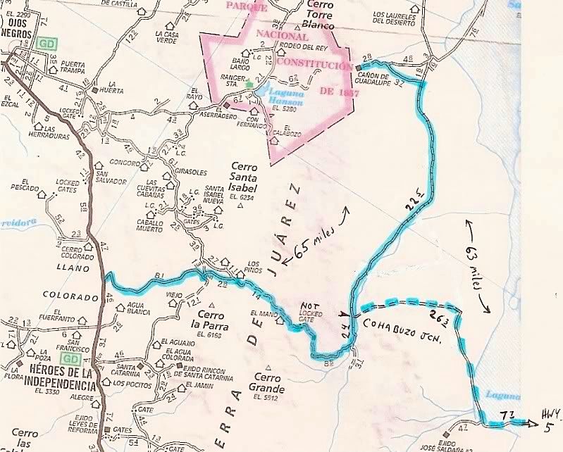
These are at Map Datum NAD27 Mexico:
Cohabuzo Jcn: 31°55.74'/ 115°36.22'
Ej. Saldana Road (S): 31°50.12'/ 115°19.47'
Hwy. 5 & Ej. Saldana Jcn: 31°51.75'/ 115°10.92'
Here is a map showing three routes out from Cohabuzo, overall distance out from Guadalupe Canyon:
|
|
|
StuckSucks
Super Nomad
Posts: 2306
Registered: 10-17-2013
Member Is Offline
|
|
... and to continue to BofLA, you could exit the bottom of Chico via Matomi Wash, then south on Highway 5. 4x4 necessary.
|
|
|
TMW
Select Nomad
Posts: 10659
Registered: 9-1-2003
Location: Bakersfield, CA
Member Is Offline
|
|
It appears that the Baja 500 files are still up. You can download the GPS files, KLM files for Google Earth and a race map.
http://score-international.com/raceinfo/course-info/baja-500...
The race course from Laguna Saluda to the Borrego crossing at Hwy 3 at KM 179 is not a smooth ride. In a stock truck or SUV it will take a while. It
is about 45 miles and will take about 3 hours +/-. It is also very remote. If traveling alone and you break down or get stuck you are on your own.
Unless you would like to explore the area I suggest you take the exit to Hwy 5 at KM87 and drive down to Hwy 3 and goes west to the Diablo Dry Lake at
KM165 or further south to the Zoo Rd alt. route to Morelia Jct. I don't remember the KM number for the Alt. Route but it's about a mile or 2 south of
the PEMEX at the Crocodile sign.
|
|
|
TMW
Select Nomad
Posts: 10659
Registered: 9-1-2003
Location: Bakersfield, CA
Member Is Offline
|
|
The 2015 SF250 course notes show the Alt. Zoo Road access from Hwy 5 at KM181.
|
|
|
kosoh
Newbie
Posts: 7
Registered: 5-20-2016
Member Is Offline
|
|
| Quote: Originally posted by StuckSucks | | If *I* was going from Cohabuzo to Valle Chico, I'd head out to Laguna Salada, then south along race course to Borrego, cross Highway 3, south on
Laguna Diablo, then a little more south, and BAM! There you are in Chico! Of course, you'll want to avoid both lakebeds if they're even a little bit
wet. |
This is what we are thinking off - are there any GPS Waypoints or route notes/maps available going North to South?
|
|
|
StuckSucks
Super Nomad
Posts: 2306
Registered: 10-17-2013
Member Is Offline
|
|
| Quote: Originally posted by kosoh | | Quote: Originally posted by StuckSucks | | If *I* was going from Cohabuzo to Valle Chico, I'd head out to Laguna Salada, then south along race course to Borrego, cross Highway 3, south on
Laguna Diablo, then a little more south, and BAM! There you are in Chico! Of course, you'll want to avoid both lakebeds if they're even a little bit
wet. |
This is what we are thinking off - are there any GPS Waypoints or route notes/maps available going North to South? |
Take a look at TMW's comments above - the SCORE web site should have race files you can follow. Also what he said: it's going to be a slow-go from
Laguna Salada to Highway 3. South of Highway 3 will be fast.
|
|
|
StuckSucks
Super Nomad
Posts: 2306
Registered: 10-17-2013
Member Is Offline
|
|
Cohabuzo is represented on a yellow dot on this map of the recent Baja 500 at Race Mile 140. Mouseover or click map dots to see info. From there, follow the course east, the south.
|
|
|
kosoh
Newbie
Posts: 7
Registered: 5-20-2016
Member Is Offline
|
|
Thanks - will give it a go tonite.
|
|
|


