| Pages:
1
2
3
4
..
8 |
PaulW
Ultra Nomad

Posts: 3005
Registered: 5-21-2013
Member Is Offline
|
|
Yes I made that track for SCORE and used both passes.
Just a stretch than maybe someone had seen a pole on one of those pass routes.
|
|
|
PaulW
Ultra Nomad
Posts: 3005
Registered: 5-21-2013
Member Is Offline
|
|
Got it - thanks
Jeep mileage is my issue to get from San Felipe and back. Going to have to plan for 190 to 200 miles between the two PMEX's
BTW, that is almost double the miles for the San Felipe PMEX going north then PLR and back over the summit to Valley Trin PMEX.
=============
Quote: Originally posted by David K  | Paul, the 73 miles is from Hwy. 2 at the Laguna Salada entrance road to the locked gate.
It is 22 miles from Hwy. 5 to the Laguna Salada road, using the toll road that stays south of Mexicali.
The Laguna Salada road at Hwy. 2 is: 32°34.560', -115°44.680'
EDIT: going west on Hwy. 2, you pass by the Laguna Salada road to make a (legal) U-turn to get back to it on the eastbound side.
[Edited on 8-9-2016 by David K] |
|
|
|
David K
Honored Nomad
Posts: 64479
Registered: 8-30-2002
Location: San Diego County
Member Is Offline
Mood: Have Baja Fever
|
|
Get gas at the Mexicali south station, then you have 200 miles via the Pole Line road to get back to San Felipe north station. Of course, 100 of those
miles is in 4WD, and maybe 50 in low range... An extra 10 gallons should give you comfort.
|
|
|
Ken Cooke
Elite Nomad
Posts: 8921
Registered: 2-9-2004
Location: Riverside, CA
Member Is Offline
Mood: Black Trans Lives Matter
|
|
The resonator was placed on backwards to reduce the unbearable noise/drone at 2,000 rpm my Jeep was exhibiting. The noise is much lower, but not to
the level I find acceptable in a daily driving scenario. The performance gains were immediately noticeable, however.
|
|
|
TMW
Select Nomad
Posts: 10659
Registered: 9-1-2003
Location: Bakersfield, CA
Member Is Offline
|
|
No it's 4 KMs to the east at KM24. Guadalupe Canyon is at KM28.
|
|
|
David K
Honored Nomad
Posts: 64479
Registered: 8-30-2002
Location: San Diego County
Member Is Offline
Mood: Have Baja Fever
|
|
You could, but the dry lake road is much smoother and faster!
They come together or a branch off the dry lake road does about 24 miles south.
|
|
|
TMW
Select Nomad
Posts: 10659
Registered: 9-1-2003
Location: Bakersfield, CA
Member Is Offline
|
|
Has anyone been to Tres Pozos (well). I've seen it on maps and SCORE calls the area near it by the name but I've never been to it.
|
|
|
David K
Honored Nomad
Posts: 64479
Registered: 8-30-2002
Location: San Diego County
Member Is Offline
Mood: Have Baja Fever
|
|
2003 Baja Almanac Folding Map:
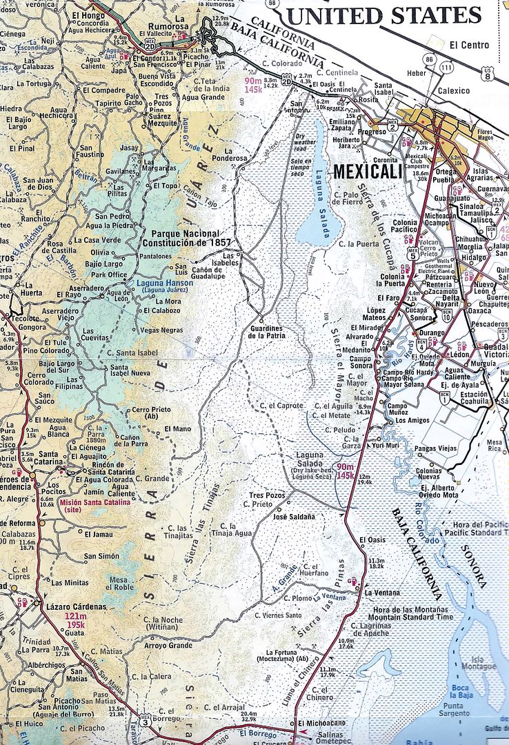
Pole Line Run arrows:
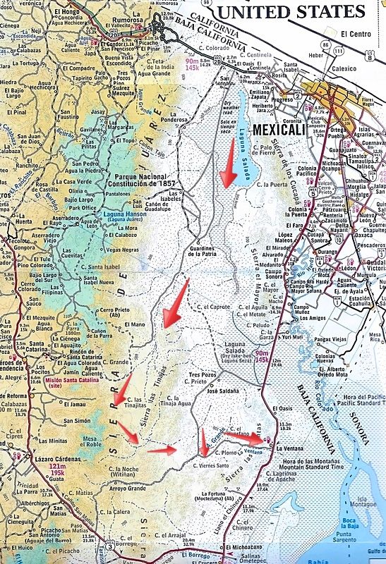
2010 AAA Map
|
|
|
David K
Honored Nomad
Posts: 64479
Registered: 8-30-2002
Location: San Diego County
Member Is Offline
Mood: Have Baja Fever
|
|
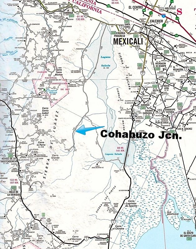
Paul: Why not meet up with Ken and the gang at Cohabuzo Jcn. as did MICK and others from Rio Hardy, last year? Access from the sand dunes and SCORE
route, 60 miles north of San Felipe, instead of going all 120 miles to Hwy. 2 and then back down to Cohabuzo?
[Edited on 8-9-2016 by David K]
|
|
|
ehall
Super Nomad
Posts: 1906
Registered: 3-29-2014
Location: Buckeye, Az
Member Is Offline
Mood: It's 5 o'clock somewhere
|
|
| Quote: Originally posted by TMW | | Has anyone been to Tres Pozos (well). I've seen it on maps and SCORE calls the area near it by the name but I've never been to it.
|
I think we were headed that direction last year but the road down the wash had completely disappeared and some of us were getting low on fuel so we
turned back.
|
|
|
David K
Honored Nomad
Posts: 64479
Registered: 8-30-2002
Location: San Diego County
Member Is Offline
Mood: Have Baja Fever
|
|
| Quote: Originally posted by ehall | | Quote: Originally posted by TMW | | Has anyone been to Tres Pozos (well). I've seen it on maps and SCORE calls the area near it by the name but I've never been to it.
|
I think we were headed that direction last year but the road down the wash had completely disappeared and some of us were getting low on fuel so we
turned back. |
To not sidebar too far from Ken's Pole Line Road post, I made a new thread on finding Tres Pozos, here: http://forums.bajanomad.com/viewthread.php?tid=83734
|
|
|
PaulW
Ultra Nomad
Posts: 3005
Registered: 5-21-2013
Member Is Offline
|
|
Well I cannot go 200 miles even in 2wd so I have to find a solution.
Will check SF to KM31 then back to Km87 (35 miles) then to Saldana and catch the race road to Cohabuzo. Miles have to be way less than 200 total.
Questions:
Jeep guys who took the last trip. How much fuel did you carry?
How many miles did the group drive from fill up to Hwy 2 at the north end of the lake bed?
Thanks
|
|
|
rich t
Nomad
Posts: 102
Registered: 4-18-2016
Member Is Offline
|
|
Paul, I was thinking about going to Guadalupe Canyon the night before,
fill up at the station about 15 miles from the turn off hwy2 and drive to
Cohabaza Jct. the next day, I have a 21 gallon tank and carry two 5
gallon cans, I hope that would make it.
|
|
|
Ken Cooke
Elite Nomad
Posts: 8921
Registered: 2-9-2004
Location: Riverside, CA
Member Is Offline
Mood: Black Trans Lives Matter
|
|
| Quote: Originally posted by PaulW | Questions:
Jeep guys who took the last trip. How much fuel did you carry?
How many miles did the group drive from fill up to Hwy 2 at the north end of the lake bed?
Thanks
|
Hi Paul,
I carry two 5 gallon jerry cans and top off in Progreso. I aired down my tires at the entrance to the Pole Line Road, providing better mileage for
the entire run. I gassed up again traveling north on the outskirts of Mexicali.
One good option is to gas up in DURANGO north of Rio Hardy and cross the Sierra el Mayor (at El Medanito, I believe - check with MICK for exact
coordinates). I have a full sequence of photos showing where we drove up the Mayor mountains and crossed the salty, muddy Rio Laguna Salada.
Our meeting place will be at Cohabuzo Junction and our campout the first evening will be a few hours south of Cohabuzo Junction.
The full trip from Progreso and back around to Mexicali was roughly 250 miles (on my odometer with 35" tires, stock speedo gears and diff gears).
Getting back to the gas station wasn't exactly on fumes, but you will be down to your last 5 gallons if you travel up the 5. MICK might be able to
chime in to share if any gas stations may be closer - such as that PEMEX in DURANGO that he took us to.
Those roughly 250 miles consumed much more gasoline than normal with all of the low range sections and sandy washes.
|
|
|
PaulW
Ultra Nomad
Posts: 3005
Registered: 5-21-2013
Member Is Offline
|
|
Thanks Ken,
10 gal is a lot to find room for.
Still planning
Latest idea is Pmex at Hwy5 k31 then back to K87 at the saldana turn, then the high road to Cohabuzo Estimate total miles to be approx 160-170. To far
for my daily tripper Jeep considering useing low range. No provision go gas cans on my Jeep.
Considered the over the mtn route from, k40, but afraid to cross the mud flats. So I ruled out that route.
Considering leaving 5 gal at La Ventana to get me back the 45 miles south to the Pmex.
Btw, Durango turn is k38, so no reason to go there vs k31 Pmex.
|
|
|
David K
Honored Nomad
Posts: 64479
Registered: 8-30-2002
Location: San Diego County
Member Is Offline
Mood: Have Baja Fever
|
|
| Quote: Originally posted by PaulW | Thanks Ken,
10 gal is a lot to find room for.
Still planning
Latest idea is Pmex at Hwy5 k31 then back to K87 at the saldana turn, then the high road to Cohabuzo Estimate total miles to be approx 160-170. To far
for my daily tripper Jeep considering useing low range. No provision go gas cans on my Jeep.
Considered the over the mtn route from, k40, but afraid to cross the mud flats. So I ruled out that route.
Considering leaving 5 gal at La Ventana to get me back the 45 miles south to the Pmex.
Btw, Durango turn is k38, so no reason to go there vs k31 Pmex. |
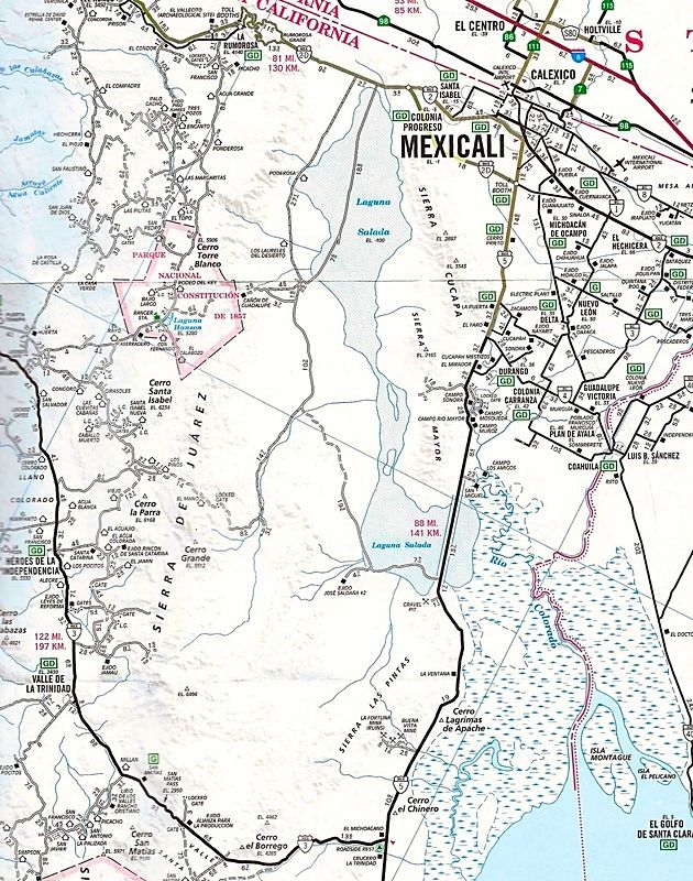
Paul, if you live in El Dorado and fill up by the crocodile Pemex... you go about 50 miles to the Sand Dunes, turn west on the Saldaña/Tres Pozos
road... continue westbound 34 miles to Cohabuzo Junction.
Cohabuzo to the Pole Line Road (locked gate/ bottom of old summit) is 26 miles... total from Pemex: 110 miles.
The Pole Line Road run (to Arroyo Grande) is 30 miles. Yes, a bunch may be in Low Range, but not all.
From Arroyo Grande junction north to the wells and then east to Hwy. 5 by La Ventana is 18 miles. La Ventana back to the Pemex near the Rockadile sign
is maybe 40 miles?
Paved road miles: 90
Dirt road miles: 110 miles
El Dorado Pemex Round trip: 200 miles.
|
|
|
Ken Cooke
Elite Nomad
Posts: 8921
Registered: 2-9-2004
Location: Riverside, CA
Member Is Offline
Mood: Black Trans Lives Matter
|
|
| Quote: Originally posted by PaulW | No provision go gas cans on my Jeep.
Btw, Durango turn is k38, so no reason to go there vs k31 Pmex. |
This should allow for 5 gallons to be carried outside of your Jeep.
Smittybilt iRack
http://www.smittybilt.com/product/index/79.htm
Where do I get a link to your map showing kilometer designations along Hwy 5?
|
|
|
David K
Honored Nomad
Posts: 64479
Registered: 8-30-2002
Location: San Diego County
Member Is Offline
Mood: Have Baja Fever
|
|
Here is the official Nomad Kilometer thread: http://forums.bajanomad.com/viewthread.php?tid=50544
HWY 5:
KM 40 Access to Laguna Salada thru mtns.
KM 49 Access to Laguna Salada east side.
KM 87 Saldana I and Tres Pozos.
KM 89 Saldana II and access to Arroyo Grande wells.
KM 105 La Ventana.
KM 107 Access thru mtn to Arroyo Grande wells.
KM 123 Gold mine road.
KM 133 Access to race courses.
KM 141 Jct with hwy 3 KM197.
KM 142 Three Poles.
KM 149 Race course access.
KM 159 Race course access.
KM 168 Race course access.
KM 179 Zoo Road.
KM 188 San Felipe Arches.
|
|
|
PaulW
Ultra Nomad
Posts: 3005
Registered: 5-21-2013
Member Is Offline
|
|
Ok list above and more here
PMEX on hwy5
k178
East toward Durango at ~k38
k31.5
k15.5
k10.0
k4.7
k4.0
k2.7
k1.0
note: jct of 5 & 2 is 2k12/5k8
PMEX
2k11
= = = = =
Edit: Added access for my PLR trip study
More that I logged that are used by many off roaders
Access to L Salida
k39 over the mtns **
k49 S of the mtns **
k69.6 O-3 **
k74 O-2 **
k77 O-1 **
Note: ** Do not drive alone because these routes are over hard crust and depending on the water table break through is possible and the need for a
tow strap will be required
"O" is my abbreviation for Oasis the old school name for these water logged mostly muddy roads.
k87 Saldana graded road
k89.4 Saldana
k92 race access
k106.6 Graded road to the Mine wells ~1KM S of La Ventana
k130.2 to Arrajal & Pinto pass
k134/5 to Arrajal & Pinto pass
[Edited on 8-12-2016 by PaulW]
|
|
|
PaulW
Ultra Nomad
Posts: 3005
Registered: 5-21-2013
Member Is Offline
|
|
Thanks David
Fills in a couple of missing numbers for me to bat around for my options.
============
| Quote: Originally posted by David K | ,
Paul, if you live in El Dorado and fill up by the crocodile Pemex... you go about 50 miles to the Sand Dunes, turn west on the Saldaña/Tres Pozos
road... continue westbound 34 miles to Cohabuzo Junction.
Cohabuzo to the Pole Line Road (locked gate/ bottom of old summit) is 26 miles... total from Pemex: 110 miles.
The Pole Line Road run (to Arroyo Grande) is 30 miles. Yes, a bunch may be in Low Range, but not all.
From Arroyo Grande junction north to the wells and then east to Hwy. 5 by La Ventana is 18 miles. La Ventana back to the Pemex near the Rockadile sign
is maybe 40 miles?
Paved road miles: 90
Dirt road miles: 110 miles
El Dorado Pemex Round trip: 200 miles.
|
|
|
|
| Pages:
1
2
3
4
..
8 |


