David K
Honored Nomad

Posts: 64479
Registered: 8-30-2002
Location: San Diego County
Member Is Offline
Mood: Have Baja Fever
|
|
EXOTIC DESERT CANYONS (Apr. 2004)
EXOTIC DESERT CANYONS (Part 1)
For those who enjoy or seek details of off pavement routes, this article has them all. The reward of seeing these water filled canyons containing blue
palms, hot springs, or petroglyphs was very much worth the effort!
On April 9th, 2004 fellow Baja enthusiast ?jide? and I set out for a three day camping and hiking trip to Baja?s Valle Chico, on the east side of the
Sierra San Pedro Martir, Baja?s tallest range of mountains.
We left San Diego before sunrise and headed south for Ensenada. Filled my Toyota Tacoma?s gas tank and two 5 gallon cans. Price was (in Pesos) $5.83/
litre and the exchange rate was 10.8 pesos : Dollar making gasoline cheaper then in San Diego, at US $2.05/ gallon.
Highway 3 from Ensenada towards San Felipe was excellent. Pemex has a gas depot at the Ojos Negros junction (about 25 miles east of Ensenada). Other
gas sources on Hwy. 3 include a gravity reservoir gas pump at Ejido de los Heroes de la Independencia (is this biggest name for a small town in all of
Mexico?), and a new station at the junction for Valle de la Trinidad.
Time to leave the pavement! About 25 miles from Valle de la Trinidad/ 100 miles from Ensenada, Highway 3 comes to the foot of a desert mountain, Cerro
el Borrego. Here a good graded road turns right and heads for the north end of Diablo Dry Lake. See Baja Almanac Map 9 (Y-6), GPS (map datum @ NAD27):
N 31-16.86?, W 115-19.22? (elev. 1,762?). It is 6.3 mi. to the dry lakebed, the road curves to the left just before reaching the lake. If dry, head
onto the lake. If wet, take the detour road on the left (east) side. Baja Almanac Map 11 (X-1).
After 13.2 miles (19.5 from Hwy. 3), the southern end of the lake is reached and at mile 19.7 from Hwy. 3 is a major fork. GPS: 31-02.84?, 115-13.01?
(elev. 1,300 ft.). Heading to the southern end of Valle Chico, we turned left at this fork (signed for San Felipe) to get to the fast East Valle Chico
road. In two days we will return to this junction coming north on the old west Valle Chico road. Baja Almanac Map 11 (Z-3). The road is now heading
east and going up hill. It is very poor condition with deep sand and lots of ?whoops? or moguls from heavy off road racing use, 4WD is employed.
At mile 28.3 (8.6 from above fork), we arrive at the east valley road, coming in from the right (south) GPS: 31-01.68?, 115-05.75? (elev. 1,913?).
Baja Almanac Map 12 (A-3). Reset odometer to 0.0 and make a sharp right turn onto a good hardpack fast road (2WD) and head south!
Lots of race arrows and ribbon at mile 12.1 to mark the racecourse?s hard left turn, off the Valle Chico road. GPS: 31-51.75?, 115-07.12?. This is a
route to Arroyo Chanate and is described in Bruce Barber?s new guide, ??of Sea and Sand.?
The east Valle Chico road passes the signed road west (right) to El Arco de Triunfo at mile 13.6. GPS: 30-50.43?, 115-07.14?. Continue heading south
for a couple more miles then the road begins to swing westward to cross the valley. Baja Almanac Map 12 (A-6).
Major intersection at mile 19.3, ahead 1.3 miles is Rancho Algodon on the old west valley road. TURN LEFT (south), GPS: 30-47.03?, 115-09.95? (elev.
1,543?). The improved road is a bit rough for a mile and the parallel sand track is better. Pass an abandoned farm (Linda Vista) on the left in 5.1
miles (GPS: 30-43.00?, 115-08.75?). Two miles further, a wide road to the right, at mile 26. 3, was the airport for Plan Nacional Agrario (Agua
Caliente). GPS: 30-41.48?, 115-08.05? (elev.1,388?). Baja Almanac Map 14 (A-1).
Arrive at the abandoned ?ejido? of Agua Caliente (Plan Nacional Agrario) at mile 27.7 from the start of the east Valle Chico road. The main road south
turns left at the occupied ranch house GPS: 30-40.33?, 115-08.05?. Straight-ahead (west) is the way to Agua Caliente Canyon (more on this, further
down).
Heading south, the road is still very good and fast for the 5.8 miles to the Carricitos fork, at mile 33.5. GPS: 30-35.67?, 115-06.98? (elev.1,938?).
Go left for Matomi Canyon, go right for Carricitos (big corral and ranch ahead), Carrizo, Berrendo, and Parral canyons. We are headed for Parral, and
take the right fork and pass the corral. The track to Carrizo turns right just beyond the corral and heads west, more later on this road. Baja Almanac
Map 14 (A-2).
1.4 miles from the Carricitos Fork, at mile 34.9 is the junction with the sandy road right to El Berrendo Canyon. GPS: 30-34.48?, 115-06.71? (elev.
1,946?). We will be back later this day to explore this one? For now jide and I continue to Parral. The surrounding mountain scenery is fantastic, and
this is a geologist or desert photographer?s dream come true! Jide soon spots some blue palms growing a mile away on a mountainside. We will return to
examine this site.
We reach Parral canyon?s arroyo (not ?Arroyo Parral? in the Almanac) at mile 37.7 (2.8 mi. from the Berrendo canyon road). GPS: 30-32.97?, 115-05.41?
(elev. 2,094?). 0.2 mi. later we arrive at the open gate and find a Baja traffic jam! I think there was about 10 vehicles some heading into the
canyon, and more heading out. Since the vehicles were sporting VIVA BAJA stickers, I new this was a friendly group of Baja explorers and the people we
had come to meet. The bigger surprise was the vehicles heading out that belonged to the intrepid Mision San Pedro Martir backpackers. Jide and I
arrived just 15 minutes after all the others met at the open Parral gate. Talk about a weird coincidence. Using a funny phrase of our late amigo
Chopy, I shouted, ?Is this the way to the Escalera Nautica??
We met Baja Lou, Wes, Dan-Over, Wild Bill (not the same one), and their companions from El Dorado in two buggies, a Baja bug, and a Toyota truck. Then
we had the pleasure to meet Mexitron, Pappy, Hudson, and Brooks who just arrived from six days with Jack Swords in search of Baja?s most difficult to
reach mission ruins, San Pedro Martir.
Mexitron and company had other friends who met them to camp the three day weekend in Matomi canyon, just south of Parral. They headed on to Matomi
after the social hour at the Parral gate. Baja Lou and his group show us the way to the big corral (Mile 40.9, or 3.0 mi. from the gate) where we will
camp this evening. Just before the corral, the road forks left but is cut off by a new fence. To get to the end of the road for the palm canyon hike,
drive into and through the corral and exit the other side. The road goes 0.6 mile to a major washout where the 1.0-mile hike begins. This we will do
the next morning. GPS at this Corral where we camp is 30-30.64?, 115-06.48?.
After our camps are set up, we headed out to explore Berrendo Canyon (Baja Almanac Map 14 (A-3). Unfortunately, the sky is cloudy for good
photography. What we saw is hard to describe, it was so fantastic for a desert. It just reminds me (again) that Baja really is a magic place! The road
from the fork into the canyon is deep arroyo sand, 4WD or buggy stuff. The road goes 3.0 miles to the trailhead, passing sheer cliffs with hundreds of
blue palms growing from the sides up to dizzying heights! Trailhead, end of road GPS: 30-32.59?, 115-07.91? (elev. 2,260?). The trail leads up the
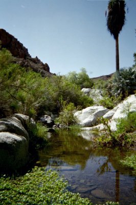
canyon past blue palms and finally water. At the end of the hike was a fantastic scene. A boulder the size of an office building on a house size
boulder with water, a big pool, and an incredible grotto. I think I was just so amazed, I didn?t know how to remember this place. Words aren?t enough!
GPS at the grotto: 30-32.11?, 115-08.11? (elev. 2,388?). The hike was under a mile. I figured how the GPS?s trip odometer works after this hike. We
all return to our camp at the Parral Corral for dinner and campfire time? so amazed by the wonders of Baja California. Little did we realize that it
would get better, the next day!!!
TO BE CONTINUED?
Attached Photo from Baja Lou of Berrendo Canyon's grotto...
All Lou's photos: http://photos.yahoo.com/boojums01
[Edited on 2-3-2005 by David K]
|
|
|
David K
Honored Nomad
Posts: 64479
Registered: 8-30-2002
Location: San Diego County
Member Is Offline
Mood: Have Baja Fever
|
|
EXOTIC DESERT CANYONS (Part 2)
Saturday April 10, 2004
Saturday morning we prepared to explore up Parral Canyon from our camp at the ?drive through? corral. Nobody in the group had been beyond the end of
the road, which was just 0.6 mi. from the corral. The road was totally washed out by a flash flood, so the hiking started at 30?30.09?, 115?06.44?
(elev. 2,610?).
The trail was fairly easy to follow as it was on the road, except where the road was in the arroyo or crossing the arroyo. About a half mile on the
trail, the road crossed the arroyo again and on the right bank was evidence of a former ?cilantro? growing project that looked like the one I saw in
Agua Caliente Canyon, 3 years ago, except the drip tubes were all hacked into pieces. Not much farther we saw water in the arroyo and blue palms. The
blue palms became more numerous and provided great photo opportunities as they stood among the giant granite boulders. The ranch road wound between
these boulder and we found rock walls that must have been made over dozens of years!
Rancho El Parral is perched on a ledge right above a running stream, exactly 1 mile, and a 30 minute walk from the trail head. Those who hiked to the
ranch spread out to explore the surrounding area. Jide and Baja Lou continued upstream and discovered the source of the stream, a huge spring where
the water just flowed out. Blue palms were everywhere, as well. GPS at the abandoned ranch house (map datum NAD27) is 30?29.42?, 115?06.97? (elev.
2,901?). In checking the GPS for the distance (straight) to Rancho El Matomi in the next canyon south, I see that it is only 3.16 miles (but over a
mountain ridge). Baja Almanac Map 14 (A-4).
Parral is incredibly beautiful and we were very fortunate that the previously locked gate was not any longer. Returning to our vehicles, Dan-Over and
I missed the trail and were staying in the arroyo. Just as I was taking another step forward, a red diamondback rattlesnake caught my attention about
two feet in front of me! He was on the arroyo?s sand in the shade of a big rock. He was stretched out and made no sound? Dan-Over came close, and it
took some effort to awaken the sleeping reptile (tossing little pebbles). We each took some photos. As with my last red diamondback encounter, (last
April with my daughter), we let him be.
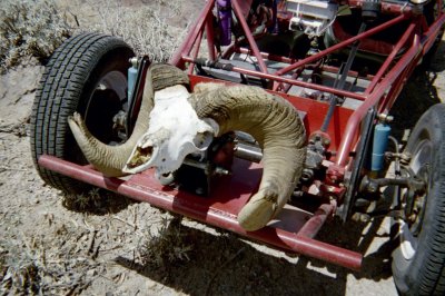
Upon arriving back at our vehicles, we see that someone discovered a full big horn sheep skull, with the entire curving horns attached. Parral was
certainly full of surprises this sunny April day. We made lunch and those waiting at the vehicles had conversations about the desert canyons. We were
waiting for the return of jide and Baja Lou, who both went way up the canyon.
Back at the corral campsite, we took a nap, did some reading in Bruce Barber?s new book http://community-2.webtv.net/boojum1/barber and got things packed up? all the while as a thunderstorm quickly built up and rained a few big drops
on us. Jide and I wanted to check out the group of blue palms and yellow slope he spotted in the next valley north of Parral. The rest of Baja Lou?s
group headed back to San Felipe (El Dorado) for Easter dinner.
We stopped and parked at the visually closest point to the ridge with palms and bright colors. GPS: 30?33.40?, 115?05.93? (elev. 2,124?) and hiked
south about ? mile. A sandy arroyo at the base of the ridge had a tire track in it, so it is possible to drive right to the base of this site from
where this arroyo crosses the Parral road. In the Baja Almanac (Map 14, A-3), see the pointy hill just left of the junction with a road (washed out)
that goes northeast to Valle Chico and down to Matomi*. This 'pointy hill' is the ridge we hiked to.
*The true main Matomi road is not shown, (north of where the road from Parral is shown bending from northeast to southeast). The Matomi road goes from
Carricitos east past the mountain then bends southeast and joins the (former) road from Parral. The fence line road to Canada el Parral (and across to
the sulfur mine area) joins the Matomi road just where it bend southeast from Carricitos.
We climbed up the ridge to the blue palms and were amazed to see the view up Valle Chico from there. GPS at the tallest palm: 30?32.86', 115?06.00'
(elev. 2,412'). No surface springs were flowing, but the dark mineralized stains on the cliff indicate water must flow more than during rare rainfall.
We also spotted a lot of onyx-like deposits on rocks from this ridge and out to almost our parking spot. It looked like melted candle wax on the
volcanic rocks. The slopes all around the palm area were covered with yellow moss. It was just so striking, I can?t wait to see the photos!
Next stop Carrizo Canyon!
Back at my truck, and off we headed? past the El Berrendo junction to Carricitos where a big corral and ranch house is located. I saw a faint track
heading east from the south side of the corral, and passing the ranch house (which is west of the corral). We followed the trail on the nice sandy
arroyo. The road curves south just over 2 miles west of Carricitos. Soon tracks go right and straight? turn right, as the road straight ahead just
ends! The right road ends 2.8 miles from Carricitos at 30?34.89?, 115?09.23? (elev. 2,361?) and we hike on, hoping the trail is short to the palms and
water. We hiked about ? mile and saw one blue palm. We were still worn out from all the hiking we already had done, and elected to explore Carrizo
Canyon another time. We wanted to have daylight to set up camp and Jide agreed that Agua Caliente Canyon would be an excellent choice.
We continued north from Carricitos the 5.6 miles to the abandoned grape-farming project of Plan Nacional Agrario, or also called (Ejido) Agua
Caliente. One old couple still lives in a ranch there, where a turn west (left) is made, GPS: 30?40.33?, 115?08.05?. The road to the canyon goes 2.0
miles southwest to the entrance. Just outside the canyon is the junction with a faint track north, which was the old road. See below (in part 3) for
GPS and description. The ranch shown in the Almanac, named Agua Caliente does not exist at the canyon entrance. We were able to drive 2.7 miles into
the canyon and that was really the limit for any vehicle. Rocks, thick vegetation, and lots of flowing water would make any further progress
impossible. Three years ago, with Lorenzo de Baja ( http://vivabaja.com/baja_2001 ) we were halted at 2.0 miles in. I just don?t see how driving all the way to the hot springs was ever possible,
even though I was told it was done. Jide spotted a nice sandy beach to set up camp, overlooking the creek at 30?39.08?, 115?11.61? (elev. 1,887?)
about 0.2 mile before the end of the road. With camp set up as it was getting dark, jide had a bottle of French wine, Trader Joe?s salami, and
Irish-Swiss cheese before our dinner of tube steaks and baked potatoes? life is good! Tomorrow we go hot spring tubbing, Baja style!
TO BE CONTINUED?
[Edited on 2-3-2005 by David K]
[Edited on 2-3-2005 by David K]
|
|
|
David K
Honored Nomad
Posts: 64479
Registered: 8-30-2002
Location: San Diego County
Member Is Offline
Mood: Have Baja Fever
|
|
EXOTIC DESERT CANYONS (Part 3, Agua Caliente)
Part 3, Easter Sunday Morning April 11, 2004
A great night?s sleep for a great day of exploring? and hot tubbing! Weather was perfect, blue skies, and no wind. The end of the road was just 2/10
of a mile from our camp, so we didn?t drive to it. The stream flows almost to the mouth of the canyon 2.7 miles away and we follow it into the
mountain in this deep canyon.
The road ends near where the canyon turns from south to west. The canyon runs almost a mile before it bends south again, near the hot springs.
Because the vegetation is so thick in the arroyo, the trail is hard to follow, but stays to the right (north) side of the canyon. I added several
?ducks? (cairns) to mark the route.
The site of the ?cilantro farm? of three years ago was abandoned, with all the drip irrigation tubing hacked up into ten thousand pieces! The terrace
is on the right (north) side of the canyon where this planting field was. The trail to the springs goes through the tree-covered terrace then back
down to the arroyo. Ahead, stay to the right side as the canyon bends left (south). Large rock dikes go from the canyon wall to the creek. The one
dike with a large quartz vein along its length goes right to the stream? feel the water? it?s HOT! About 105 degrees at this point GPS: 30-38.90?,
115-12.44 (elev. 2,017?). The source of the hot stream is 336 feet away at AGUA CALIENTE CANYON HOT SPRINGS* at 30-38.85?, 115-12.41? (elev. 2,041?).
(* Sometimes called Valle Chico Hot Springs).
Jide dug a tub in the sand and diverted the hot stream to fill it, I soaked in the creek by the quartz stripe (a bar of soap was there). The tub near
the source spring was far too hot to use. One book says the water temperature of the springs is 144 degrees! The springs (at least three) are on the
terrace and the steaming water flows down to the arroyo. Photos from last time here: http://davidksbaja.com/baja_2001/page2.html
Reluctantly, we returned to our camp, 1.3 miles and 33 minutes away for lunch and to pack up for our next objective? El Cajon Canyon?`
TO BE CONTINUED?
Photo of steaming creeks from 12-31-00 visit with LdB:
|
|
|
David K
Honored Nomad
Posts: 64479
Registered: 8-30-2002
Location: San Diego County
Member Is Offline
Mood: Have Baja Fever
|
|
Part 4, Sunday Afternoon April 11, 2004
Coming out of Agua Caliente Canyon, we spotted a faint track, which was the old road north. It starts at the newer road from the abandoned village and
ranch house at 30-39.60?, 115-09.61 (elev. 1,566?), 2.8 miles out from the end of the canyon road. We took the old road, it was fast and sandy for the
3.8 miles to the junction with the new road at 30-42.51?, 115-08.52 (elev. 1,318?). The abandoned Plan Nacional Agrario is 2.7 miles south, and the
abandoned Rancho Linda Vista is 0.6 mile north at 30-43.00?, 115-08.75? (elev. 1,331?). 5.1 miles further north is the major intersection where the
fast east Valle Chico road (from San Felipe) turns right (east) and the road to Rancho Algodon turns left (west). This waypoint was given in the first
part (30-47.03?, 115-09.95?). We turn left to visit El Cajon Canyon? a major chasm in the sierra?s east face.
Rancho Algodon?s driveway (left) was 1.3 miles west of the intersection on the old (west) Valle Chico road. We set our trip odometer to zero and now
are heading north at the foot of the mighty Sierra San Pedro Martir. 2.0 miles north of Algodon?s driveway is a fork in the road. To the right is
Morelia, we stay left. 1.0 miles further we come to a closed gate and cattle guard. 4.3 miles north of Algodon is a road left, we suspect goes to El
Borroso Canyon. This one will have to wait until next time, we have an appointment with El Cajon!
6.1 miles north of Algodon is the access road to El Cajon at 30-51.32?, 115-13.38? (elev. 1,808?). We turn west and in 0.6 mile in is a closed
?Prohibido? gate with a ranch just inside. We park the truck and walk north, down into the big arroyo where a opening in the fence for cattle and
people can pass. Soon jide spots a large boulder filled with petroglyphs high on the canyon?s north cliff and he climbs up for a closer investigation.
A bit further and water is flowing. Soon we see a new huge steel water reservoir that looks too good to not jump in? But, without a ladder we may not
get in (or out)!
We continue up stream to the first water falls, a quarter mile from the fence opening. Jide and I agree that inside this canyon does not resemble Baja
in any way, except for the cardon cacti on the slopes. Less than a mile from the hot San Felipe desert, is a cool mountain stream, willow trees,
grass, just like in the coastal mountains. We want to see more of this exotic (for eastern Baja) canyon. About a half mile further is a low concrete
dam creating a shallow pond at 30-51.07?, 115-14.62? (elev. 2,043?).
Our legs have had just about enough hiking this weekend, we elect to not explore any further (this time).
Upon returning to my truck, a man walks to the gate from the ranch house, inside. He calls to us, speaking English? He tells us his name is Bob. We
introduce ourselves (David and Gerald), and Bob then asks me if I am ?David K?! He then tells us he is ?Burro Bob? from the Baja Nomad forums. Instant
amigos? he invites us into the compound, and shows us his beautiful photographs from area canyons. This was certainly a surprise to find an American
living on a remote ranch, then to find that we ?know? each other, from the Internet! We part with an exchange of handshakes and Viva Baja stickers, it
will be a long trip home this evening.
Reset trip odometer at the back at the valley road to zero. Head north, crossing Arroyo El Cajon and at mile 0.8 is a fork, we stay left. Mile 4.2 a
road joins in from the right (east). Mile 7.3 is a closed gate (sure is great to have a passenger for gate duty!). At mile 8.0 is a road left (west)
we suspect goes to Teledo Canyon, GPS: 30-57.76?, 115-13.18? (elev. 1,645?). At mile 10.2 is an open gate with a road along its south side heading
towards the mountain range. Mile 11.9 brings us to another closed gate by a ranch and an abandoned vineyard project. Mile 12.9 from El Cajon?s access
road is a big farm project with a large Quonset building. There is a fork in the road, and we go right and this road bends around the fence heading
east. At mile 13.4 we turn left (north) and at mile 14.8 we join the Diablo Dry Lake to San Felipe road where we were two days previous, on our way
south (31-02.84?, 115-13.01). Soon we are back on the dry lake racing north? we keep staring toward Picacho del Diablo hoping to see Desert Rat, our
amigo who is climbing Baja?s highest peak. Back at Highway 3, and we turn towards Ensenada. Traffic returning from Easter in San Felipe is heavy as we
near Ensenada because of the four way stop signs. We get to the border about 9:20pm and are across in 40 minutes.
Another fantastic trip and further proves that Baja California is truly a magic place. Jide was a terrific travel companion and we are looking forward
to future Baja explorations to come!
Photos of this trip at http://vivabaja.com/404
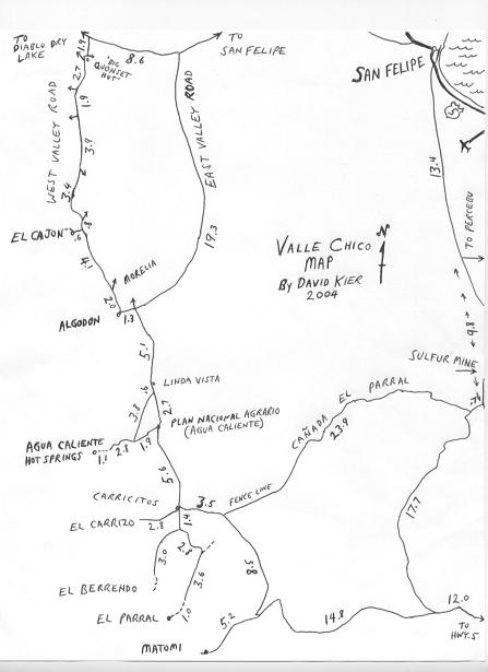
Here?s a map I just whipped up of the area covered by this article
[Edited on 2-3-2005 by David K]
|
|
|
bajalou
Ultra Nomad
Posts: 4459
Registered: 3-11-2004
Location: South of the broder
Member Is Offline
|
|
Great reminder of that weekend David. Hoping to get back to Parral sometime this spring also. A couple weeks later, Jim Bill and I hiked to the hot
springs in Agua Caliente. Great spots!

No Bad Days
\"Never argue with an idiot. People watching may not be able to tell the difference\"
\"The trouble with doing nothing is - how do I know when I\'m done?\"
Nomad Baja Interactive map
And in the San Felipe area - check out Valle Chico area |
|
|
David K
Honored Nomad
Posts: 64479
Registered: 8-30-2002
Location: San Diego County
Member Is Offline
Mood: Have Baja Fever
|
|
Yes indeed.. It was a great weekend (Easter, 2004)!
There are a lot more canyons to explore north of Agua Caliente, besides El Cajon. Note my map of the several roads going west from the original (west
side) Valle Chico road...
Stay tuned!
By the way, when I saw that Doug made this special forum (Trip Reports), I thought it would be good to search the forums from 2002 and duplicate the
detailed posts of mine here, so they are easier to find... if that would help any Nomads find some adventure to go on!
|
|
|
jide
Nomad
Posts: 245
Registered: 4-9-2003
Location: san diego
Member Is Offline
|
|
David
that was a great trip! I am thinking to do diablo canyon or arroyo grande sometimes in april, are you up for it?

|
|
|
David K
Honored Nomad
Posts: 64479
Registered: 8-30-2002
Location: San Diego County
Member Is Offline
Mood: Have Baja Fever
|
|
| Quote: | Originally posted by jide
David
that was a great trip! I am thinking to do diablo canyon or arroyo grande sometimes in april, are you up for it?
|
YES!
Spring Break this year is Mar. 26 - Apr. 3... Probably going to Camp Gecko for part of that time...
Another weekend is a possibilty for Arroyo Grande (north of San Juan de Dios), as we can go to Baja Cactus Motel Friday night and drive out to El
Sauce de Carter or where-ever you want to start the hike the next morning... and I can drive home Sunday night.
Thanks for keeping the idea alive!
I will give you a call this weekend, as I have a grapic arts question for you.
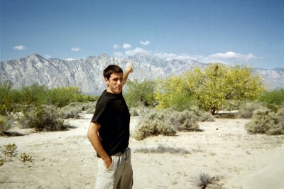
Here's 'jide' pointing to Diablo last April (we thought Desert Rat was up there that day)...
|
|
|
|


