| Pages:
1
2 |
StuckSucks
Super Nomad

Posts: 2306
Registered: 10-17-2013
Member Is Offline
|
|
Baja 1000 GPS files
Now released: http://score-international.com/raceinfo/gps-files-baja-1000/
|
|
|
BigBearRider
Super Nomad
Posts: 1299
Registered: 4-30-2015
Location: Big Bear, Punta Chivato, and Cabo
Member Is Offline
Mood: 
|
|
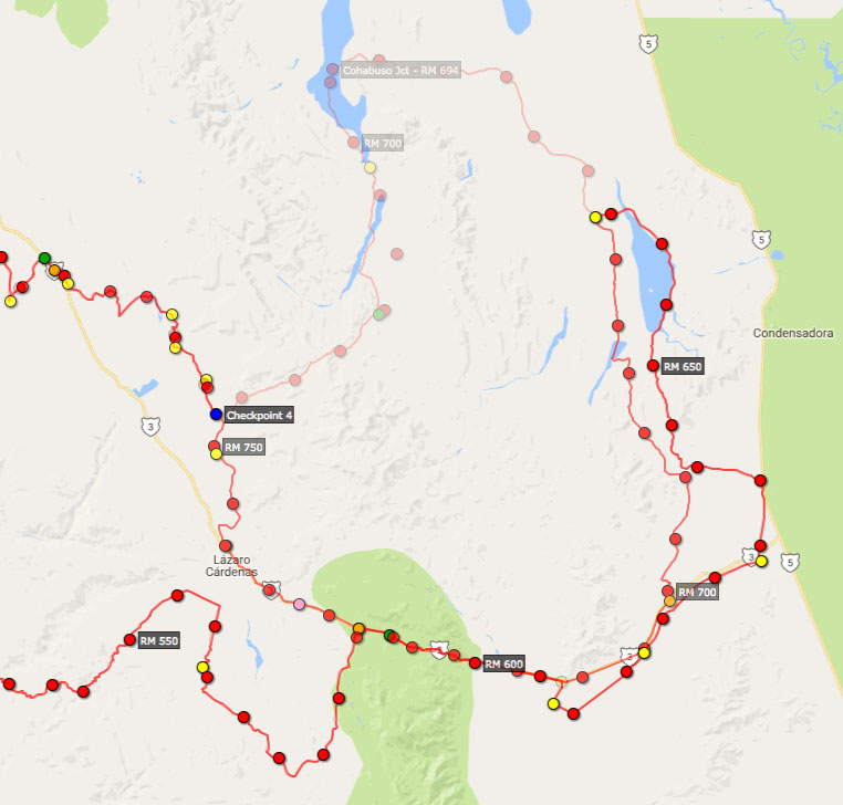
An interesting loop. One of the most northwestern 1000 maps that I can recall seeing.
|
|
|
David K
Honored Nomad
Posts: 64479
Registered: 8-30-2002
Location: San Diego County
Member Is Offline
Mood: Have Baja Fever
|
|
Please post when you have a Google Earth overlay. The latest Score map is such low quality I don't want to even bother trying view it.
|
|
|
TMW
Select Nomad
Posts: 10659
Registered: 9-1-2003
Location: Bakersfield, CA
Member Is Offline
|
|
I like the course. The far south route I have not been on for a very long time and some areas I've never been on so I'm think of running it from RM265
to RM465.
|
|
|
StuckSucks
Super Nomad
Posts: 2306
Registered: 10-17-2013
Member Is Offline
|
|
Here's the 1000 course embedded in Google Maps
|
|
|
rts551
Elite Nomad
Posts: 6699
Registered: 9-5-2003
Member Is Offline
|
|
Already a change in the course. new maps available later today
|
|
|
StuckSucks
Super Nomad
Posts: 2306
Registered: 10-17-2013
Member Is Offline
|
|
Yes, they're going to remove the up-Summit part of the course (probably a good idea). I will change this map as SCORE releases changes.
|
|
|
rts551
Elite Nomad
Posts: 6699
Registered: 9-5-2003
Member Is Offline
|
|
For those that wish to view the course in Google Earth, it is simple. On the SCORE web site click on the KML file. Tell the response you want to
open it with Google Earth. Or Save the file. and open it with Google Earth. Either way, very simple.
[Edited on 10-21-2016 by rts551]
|
|
|
rts551
Elite Nomad
Posts: 6699
Registered: 9-5-2003
Member Is Offline
|
|
One observaion....HWY 1 will be very congested with chase vehicles. Almost makes me not want to go.
|
|
|
David K
Honored Nomad
Posts: 64479
Registered: 8-30-2002
Location: San Diego County
Member Is Offline
Mood: Have Baja Fever
|
|
Thank you, Ralph, that was very helpful of you.
|
|
|
PaulW
Ultra Nomad
Posts: 3005
Registered: 5-21-2013
Member Is Offline
|
|
What a joke Race on the highway at 60MPH just because someone said the summit was hard. FYI, the summit is easier than ever before due to the new road
that Bypasses all the hard stuff on the N side.
|
|
|
Bajaboy
Ultra Nomad
Posts: 4375
Registered: 10-9-2003
Location: Bahia Asuncion, BCS, Mexico
Member Is Offline
|
|
Thanks, think we're going to set up same place as last year! Looking forward to getting dusty!
|
|
|
willardguy
Elite Nomad
Posts: 6451
Registered: 9-19-2009
Member Is Offline
|
|
 ....I can't wait! that means 45 days till DAKAR!!!!!! ....I can't wait! that means 45 days till DAKAR!!!!!!
|
|
|
TMW
Select Nomad
Posts: 10659
Registered: 9-1-2003
Location: Bakersfield, CA
Member Is Offline
|
|
Last June 2015 we drove over the summit east to west and it was a piece of cake and we were all in basically stock vehicles with a lift except Roy in
his Rover, it was all stock.
|
|
|
PaulW
Ultra Nomad
Posts: 3005
Registered: 5-21-2013
Member Is Offline
|
|
Tom, From the sound of the problems they had I suspect they were using the old SCORE track. As you know that is the two tracks on the left as they
were going up. They probably were not even aware of the new road that bypasses all the washouts. To late to change they rerouted.
All because the marking guys that had never driven the summit since the new road was built.
|
|
|
StuckSucks
Super Nomad
Posts: 2306
Registered: 10-17-2013
Member Is Offline
|
|
Merely FYI, I overlaid the two different courses on top of each other - you can see the the faded old loop on the north. It will be interesting to see
the difference in mileages.
|
|
|
David K
Honored Nomad
Posts: 64479
Registered: 8-30-2002
Location: San Diego County
Member Is Offline
Mood: Have Baja Fever
|
|
Thanks Paul.
|
|
|
PaulW
Ultra Nomad
Posts: 3005
Registered: 5-21-2013
Member Is Offline
|
|
Quote: Originally posted by StuckSucks  | Merely FYI, I overlaid the two different courses on top of each other - you can see the the faded old loop on the north. It will be interesting to see
the difference in mileages.
[img]http://pizzamanagement.com
======
Thanks for the two track overlays
Just curious I cannot get the SCORE LV4 USR file to open. Do you know what it is about?
I want to drive the summit in my latest baja rig. V Trinidad up & over and to the bottom to Arroyo Saiz and back. I will be available to do it on
the 30th or later. Send me a U2U and we can get together.
PW |
|
|
|
David K
Honored Nomad
Posts: 64479
Registered: 8-30-2002
Location: San Diego County
Member Is Offline
Mood: Have Baja Fever
|
|
So Hwy. 3 from the Mike's Sky Rancho junction to San Matias Pass will have TWO-WAY race traffic (plus the public) now, that someone thought the Summit
is too difficult for the race machines!
There is another road over the mountain between Valle Trinidad and Rancho Arroyo Grande, as I recall?
|
|
|
mtgoat666
Select Nomad
Posts: 17295
Registered: 9-16-2006
Location: San Diego
Member Is Offline
Mood: Hot n spicy
|
|
| Quote: Originally posted by David K | So Hwy. 3 from the Mike's Sky Rancho junction to San Matias Pass will have TWO-WAY race traffic (plus the public) now, that someone thought the Summit
is too difficult for the race machines!
There is another road over the mountain between Valle Trinidad and Rancho Arroyo Grande, as I recall? |
More opportunities to kill spectators and general public!
What is the average number of deaths per Baja 1000?
|
|
|
| Pages:
1
2 |


