| Pages:
1
..
3
4
5
6
7 |
rich t
Nomad

Posts: 102
Registered: 4-18-2016
Member Is Offline
|
|
If you were heading north from San Ignacio and you reach the sign that says El Gato there is a turn to the North with a sign that says El trufino, it
is about 13 miles South east of San Casimino.
|
|
|
bburnsman
Newbie
Posts: 3
Registered: 10-1-2015
Member Is Offline
|
|
Recently in El Barril
I was in El Barril last week. We tried to go south from town to see how far we could get on the trail. Prior to doing so, we spoke to locals because
we were interested in how the hurricanes had treated the area. Locals reported that might not be the biggest problem. They said something about a goat
farm or ranch and that there are gates erected with locks and no trespassing signs. Being non-believers, we went down the trail and it wasn't two
miles till we hit the gates and signs. closed up tight.
|
|
|
rich t
Nomad
Posts: 102
Registered: 4-18-2016
Member Is Offline
|
|
The route I am interested in would by pass the No Wimps trail, going south you would leave San Francisquito and take the road heading to El Arco,
after passing thru Rancho Piedra Blanca the road makes a Y, take the left spur which on my map goes to Rancho Miraflores, from there you would go thru
santa Gertrudis, then head south pass thru El Carrizzo to San Casimiro, then to El Trufino which ties you back into the road to San Ignacio west of El
Gato. The map I am using may have different names for some of the ranches, it is a programmable Mexican map.
|
|
|
PaulW
Ultra Nomad
Posts: 3004
Registered: 5-21-2013
Member Is Offline
|
|
Rich,
I cannot find El Trufino on the Almanac. Can you tell me a place nearby drainage, or mountain. I see no track leading north from near el Gato, but it
shows the road we used to get to el Gato from the south.
Thanks
|
|
|
rich t
Nomad
Posts: 102
Registered: 4-18-2016
Member Is Offline
|
|
Paul, we will be in Baja tomorrow, will talk to you then, if you look on Henrys map you will see El Trufino, there is also a sign on the road by the
El Gato sign which is west of El Gato. The El Trufino road looks pretty good at that point.
|
|
|
David K
Honored Nomad
Posts: 64476
Registered: 8-30-2002
Location: San Diego County
Member Is Offline
Mood: Have Baja Fever
|
|
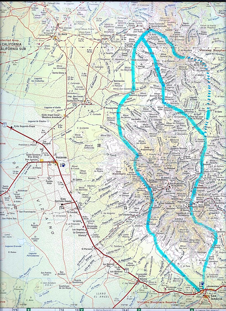
I am with Paul on this Rich. I was at Guillermo Prieto and Prosperidad, as well as Miraflores to Santa Gertrudis this past summer, so I was all
around.
The trails between Santa Gertrudis and San Ignacio (via San Casimiro and El Gato, etc.) are mission roads from the 1700s, known as El Camino Real.
There were three routes between the two missions of San Ignacio and Santa Gertrudis: Sierra, Golfo, Pacifico.
Modern roads are over the top of some of these trails. Google Earth is your friend at following them.
[Edited on 11-9-2017 by David K]
|
|
|
David K
Honored Nomad
Posts: 64476
Registered: 8-30-2002
Location: San Diego County
Member Is Offline
Mood: Have Baja Fever
|
|
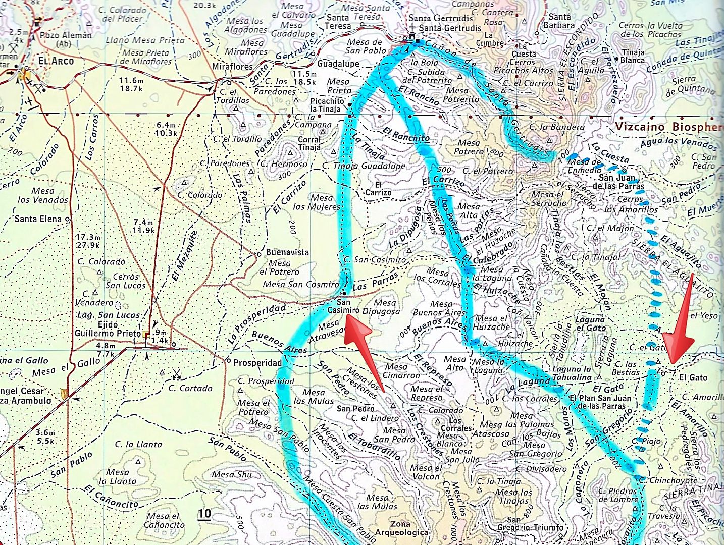
El Gato and San Casimiro are pointed out.
|
|
|
PaulW
Ultra Nomad
Posts: 3004
Registered: 5-21-2013
Member Is Offline
|
|
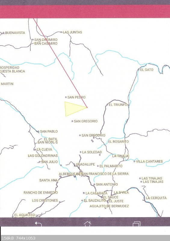
Above on DK map. Found it on Henry's map (EL Triunfo). I suspect the route is the mid one passing thru San Gregorio drainage. Rich will clarify later.
|
|
|
David K
Honored Nomad
Posts: 64476
Registered: 8-30-2002
Location: San Diego County
Member Is Offline
Mood: Have Baja Fever
|
|
Quote: Originally posted by PaulW  | | Above on DK map. Found it on Henry's map (EL Triunfo). I suspect the route is the mid one passing thru San Gregorio drainage. Rich will clarify later.
|
I see a Triumfo at the bottom of the above map but, nowhere near the line between San Casimiro and El Gato... unless there is another one, too?
|
|
|
PaulW
Ultra Nomad
Posts: 3004
Registered: 5-21-2013
Member Is Offline
|
|
Henry's map shows a road looping from El Gato road nw then S to San Gregorio. And it shows another SG north of the track? No connection for the road
Rich describes. Clarification needed.
Probably driving the roads will give clarity.
|
|
|
David K
Honored Nomad
Posts: 64476
Registered: 8-30-2002
Location: San Diego County
Member Is Offline
Mood: Have Baja Fever
|
|
| Quote: Originally posted by PaulW | Henry's map shows a road looping from El Gato road nw then S to San Gregorio. And it shows another SG north of the track? No connection for the road
Rich describes. Clarification needed.
Probably driving the roads will give clarity. |
Maybe you could show us what Henry's Map looks like?
|
|
|
PaulW
Ultra Nomad
Posts: 3004
Registered: 5-21-2013
Member Is Offline
|
|
| Quote: Originally posted by David K | | Quote: Originally posted by PaulW | Henry's map shows a road looping from El Gato road nw then S to San Gregorio. And it shows another SG north of the track? No connection for the road
Rich describes. Clarification needed.
Probably driving the roads will give clarity. |
Maybe you could show us what Henry's Map looks like? |
======= =
Screen shot
|
|
|
motoged
Elite Nomad
Posts: 6481
Registered: 7-31-2006
Location: Kamloops, BC
Member Is Offline
Mood: Gettin' Better
|
|
El Triunfo or El Trufino ? ......dyslexics make poor cartographers 
Don't believe everything you think....
|
|
|
PaulW
Ultra Nomad
Posts: 3004
Registered: 5-21-2013
Member Is Offline
|
|
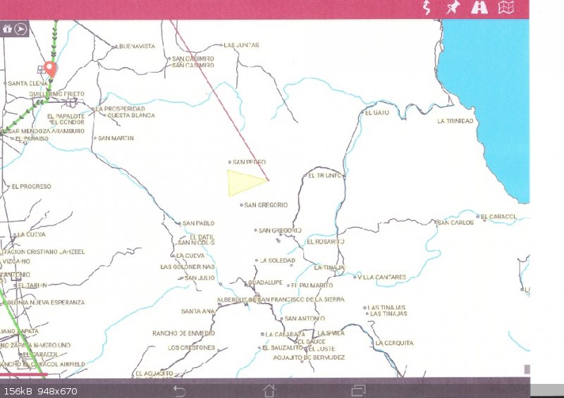
screen shot
Again
Learning new stuff
|
|
|
mtgoat666
Select Nomad
Posts: 17280
Registered: 9-16-2006
Location: San Diego
Member Is Offline
Mood: Hot n spicy
|
|
| Quote: Originally posted by David K | I am with Paul on this Rich. I was at Guillermo Prieto and Prosperidad, as well as Miraflores to Santa Gertrudis this past summer, so I was all
around.
The trails between Santa Gertrudis and San Ignacio (via San Casimiro and El Gato, etc.) are mission roads from the 1700s, known as El Camino Real.
There were three routes between the two missions of San Ignacio and Santa Gertrudis: Sierra, Golfo, Pacifico.
Modern roads are over the top of some of these trails. Google Earth is your friend at following them.
[Edited on 11-9-2017 by David K] |
Your blue-lined routes are mostly inside the world heritage site boundary, in area controlled by biosphere reserve and INAH.
why are y'all strategizing offroading in the restricted areas?
here is a map so you can stay out of trouble:
http://lugares.inah.gob.mx/images/zonas/croquis/Sierra_San_F...
the map on left is protected area boundary (not the inset map)
Woke!
“...ask not what your country can do for you – ask what you can do for your country.” “My fellow citizens of the world: ask not what America
will do for you, but what together we can do for the freedom of man.”
Prefered gender pronoun: the royal we
|
|
|
David K
Honored Nomad
Posts: 64476
Registered: 8-30-2002
Location: San Diego County
Member Is Offline
Mood: Have Baja Fever
|
|
Nobody told the padres, goat. The blue lines are routes the CAMINO REAL from about 1750 to 1800s, even used beyond and to today. Most of the area is
too rugged for automobiles and that is why car roads went around the mountains and not over them.
|
|
|
rts551
Elite Nomad
Posts: 6699
Registered: 9-5-2003
Member Is Offline
|
|
Yes...Too bad the padres didn't know about the biosphere. LOL
|
|
|
PaulW
Ultra Nomad
Posts: 3004
Registered: 5-21-2013
Member Is Offline
|
|
Goat,
Not a relevant comment. Nobody is suggesting we would drive off existing roads. Many of the roads we are discussing are not be depicted on the various
maps, but many exist and we are just trying to find them before we drive.
David's blue lines are just for orientation to get us in the region of discussion.
|
|
|
TMW
Select Nomad
Posts: 10659
Registered: 9-1-2003
Location: Bakersfield, CA
Member Is Offline
|
|
The Biosphere Reserve does not prohibit driving on existing roads. That's how the ranchers get around.
|
|
|
bajatrailrider
Super Nomad
Posts: 2423
Registered: 1-24-2015
Location: Mexico
Member Is Offline
Mood: Happy
|
|
| Quote: Originally posted by TMW | | The Biosphere Reserve does not prohibit driving on existing roads. That's how the ranchers get around. |
That is true as all ranchers use the roads to travel in the reserves. MT has no knowledge of Baja
just a clueless tourist.
|
|
|
| Pages:
1
..
3
4
5
6
7 |


