Gulliver
Senior Nomad

Posts: 651
Registered: 11-18-2013
Member Is Offline
|
|
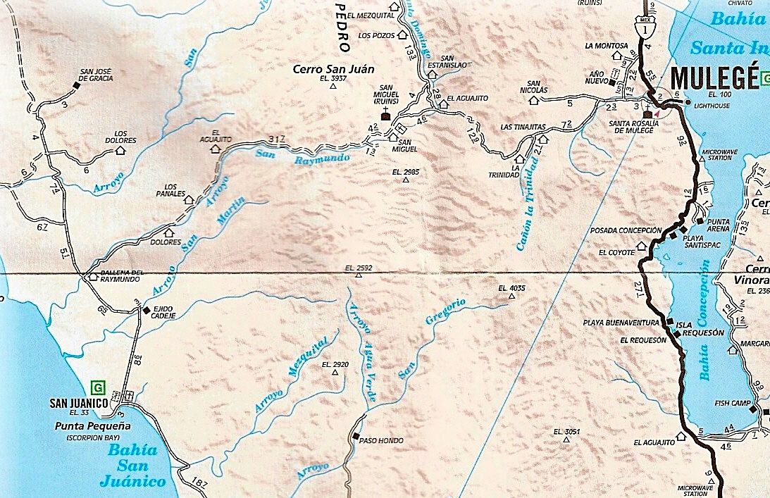
West of Mulege December 2016
I just arrived in Mulege of the Winter and went on my first ride out West of town. As is usual after a Summer flood the first few miles headed for San
Juanico are have been considerably modified. To avoid wasting your time exploring paths to various local rancheros, I suggest saving this set of
instructions.
Mulege West
Leave Route 1 at Icehouse Road 0 miles
End of pavement 1.1
Straight at Y 2.7
Right at Y 2.8
Left after cattle guard 5.2
Right at Y 8.4
From here on out it is hard to get lost. I'll be checking out more of the route in the coming weeks.
Enjoy.
[Edited on 12-13-2016 by Gulliver]
|
|
|
David K
Honored Nomad
Posts: 64490
Registered: 8-30-2002
Location: San Diego County
Member Is Offline
Mood: Have Baja Fever
|
|
Keep up the good work!!!
|
|
|
Gulliver
Senior Nomad
Posts: 651
Registered: 11-18-2013
Member Is Offline
|
|
Glancing at the map, I see that the road from Dolores to Ejido Cadaje is not shown. Instead of taking the right hand fork at Dolores and climbing up
on top, you can bear left and the road to Cadaje saves you a few miles of boring stuff out through the flat country.
Unless you are planning to head North up the coast and don't need gas (not always available in Ballena).
The road from Cadaje to San Juanico is a gravel freeway. Way too easy to get overcooked!
|
|
|
AKgringo
Elite Nomad
Posts: 5819
Registered: 9-20-2014
Location: Anchorage, AK (no mas!)
Member Is Offline
Mood: Retireded
|
|
Gulliver, Motoged, 03dave and I did that run on Thanksgiving day. The west side of the divide is in far worse condition than anything through the
pass. Most of the San Raymundo arroyo has no road at all, except for a Cat track.
We took the cut off to Ejido Cadeje, but it put us back in the arroyo for a couple of more miles and water crossings. I was so beat up by then, that
it pained me to turn away from the road to Ballena since it looked to at least be a road!
Here is a link; http://forums.bajanomad.com/viewthread.php?tid=81192&got...
[Edited on 12-13-2016 by AKgringo]
If you are not living on the edge, you are taking up too much space!
"Could do better if he tried!" Report card comments from most of my grade school teachers. Sadly, still true!
|
|
|
David K
Honored Nomad
Posts: 64490
Registered: 8-30-2002
Location: San Diego County
Member Is Offline
Mood: Have Baja Fever
|
|
Quote: Originally posted by Gulliver  | Glancing at the map, I see that the road from Dolores to Ejido Cadaje is not shown. Instead of taking the right hand fork at Dolores and climbing up
on top, you can bear left and the road to Cadaje saves you a few miles of boring stuff out through the flat country.
Unless you are planning to head North up the coast and don't need gas (not always available in Ballena).
The road from Cadaje to San Juanico is a gravel freeway. Way too easy to get overcooked! |
Thanks for that.
It is the 2010 AAA map and the club didn't include roads that are questionable or that members may complain about. They removed many roads from their
earlier maps because some members complained they were "too rough"! What do they think Baja roads are supposed to be? LOL
|
|
|
Gulliver
Senior Nomad
Posts: 651
Registered: 11-18-2013
Member Is Offline
|
|
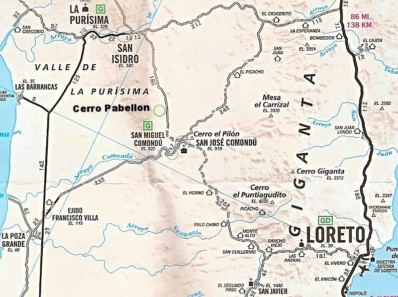
AKgringo. In that report you mention going North from Comundu to Purisma. Was that around by the paved road or over the hill up past the cemetery? And
if by the dirt route what was it like?
I need to scout out the side road up to the top of Cerro Pabellon this Winter for Baja 1000 radio relay purposes.
|
|
|
David K
Honored Nomad
Posts: 64490
Registered: 8-30-2002
Location: San Diego County
Member Is Offline
Mood: Have Baja Fever
|
|
| Quote: Originally posted by Gulliver | AKgringo. In that report you mention going North from Comundu to Purisma. Was that around by the paved road or over the hill up past the cemetery? And
if by the dirt route what was it like?
I need to scout out the side road up to the top of Cerro Pabellon this Winter for Baja 1000 radio relay purposes.
|
|
|
|
PaulW
Ultra Nomad
Posts: 3009
Registered: 5-21-2013
Member Is Offline
|
|
Comondu to La Purisima
Based on my experience that road needs to have a current report. The time I drove it it was terrible and took a very long time to get over the summit.
4X4 was needed and I had to spot my wife in an out of the washouts. And yes I saw the Score radio relay signs from previous use at the washout area.
This report is definitely not current.
|
|
|
AKgringo
Elite Nomad
Posts: 5819
Registered: 9-20-2014
Location: Anchorage, AK (no mas!)
Member Is Offline
Mood: Retireded
|
|
We arrived in San Miguel Comondu via the paved road in from the west (Ejido Francisco Villa). The dirt road leading toward San Jose Comondu, and
turned on to a narrow road heading north through a palm grove. I don't know about a graveyard.
The road has had repairs done on much of it, and probably 95% of it is in good 2wd condition. I did put my Kia if 4x4 on the grades, to keep from
tearing the road up, and there are a few places that require crawling over bedrock portions.
I liked it better than the road from San Isidro east to Mex 1!
If you are not living on the edge, you are taking up too much space!
"Could do better if he tried!" Report card comments from most of my grade school teachers. Sadly, still true!
|
|
|
mcnut
Nomad
Posts: 177
Registered: 12-9-2013
Location: Dammeron Valley, UT
Member Is Offline
|
|
I have been asking/looking for information on the route which leaves NE form Comondu (passing by El Picacho on David's last map) without any luck. I
believe I rode it 20 years ago, but have never seen an update.
Any info in this alternate route?
Bruce
|
|
|
Gulliver
Senior Nomad
Posts: 651
Registered: 11-18-2013
Member Is Offline
|
|
In my coming explorations down to that area I'll probably take along camp gear so I can slow down a bit. Last year I did the Purisma to Comundu leg
with one other bike and we just shot through. But A: that's on a bike, and B: we are crazy. The washouts about five miles in from the North were , I
think, duable with 2WD and the descent into Comundu was best taken slowly as trucks ascending had hollowed out all sorts of pits and hog wallows. The
Comundu cemetery is right near the top of that grade.
Keep in mind that I know less than nothing about four wheel off road travel. Thing that I fly over at high speed would wreck a truck and rock piles
that a 4WD can crawl up will stop me dead. I'm usually riding solo and am allergic to broken hips out in the dingle berries!
I will be carrying a SPOT tracker and can post a link to my slime trail on here.
I have not heard of anyone driving that road from Comundu to the N.E. recently. I will look for the North end of it this year some time. it was part
of the main route many years ago. Before my time.
Any road reports from previous to a Summer flood season are taken with a 1000 lb. grain of salt. Stuff happens.
[Edited on 12-14-2016 by Gulliver]
|
|
|
motoged
Elite Nomad
Posts: 6481
Registered: 7-31-2006
Location: Kamloops, BC
Member Is Offline
Mood: Gettin' Better
|
|
The road from Comondu to San Isidro is very manageable w/ 2-wheel drive vehicle ...a snap on a bike....
The graveyard , Gary, was just to the left as we were going up out of Comondu...
The cut-off to the road NE out of Comondu looked like it has seen little use....last time i saw it was in 2011 w/ DT Bushpilot....we rode up it
several miles and turned back, realizing (thank the gods) it was the wrong track...sorry we didn't get to see the lake up that road.
Don't believe everything you think....
|
|
|
mcnut
Nomad
Posts: 177
Registered: 12-9-2013
Location: Dammeron Valley, UT
Member Is Offline
|
|
Thanks for the info!
Bruce
|
|
|
David K
Honored Nomad
Posts: 64490
Registered: 8-30-2002
Location: San Diego County
Member Is Offline
Mood: Have Baja Fever
|
|
| Quote: Originally posted by mcnut | I have been asking/looking for information on the route which leaves NE form Comondu (passing by El Picacho on David's last map) without any luck. I
believe I rode it 20 years ago, but have never seen an update.
Any info in this alternate route?
Bruce
|
Much of that route was the main road to La Paz from Tijuana before 1971 when the new highway was changed to go through Loreto from Insurgentes. An
alternate to the Comondú route but a few miles longer was through La Purísima.
|
|
|


