imlost
Nomad

Posts: 217
Registered: 3-31-2015
Location: PNW & East Cape
Member Is Offline
|
|
Google Earth Satellite Imagery Update
If you haven't looked at Baja on Google Earth in the last few days, it's worth a peek. The satellite imagery has been updated. WAY more detail.
|
|
|
StuckSucks
Super Nomad
Posts: 2307
Registered: 10-17-2013
Member Is Offline
|
|
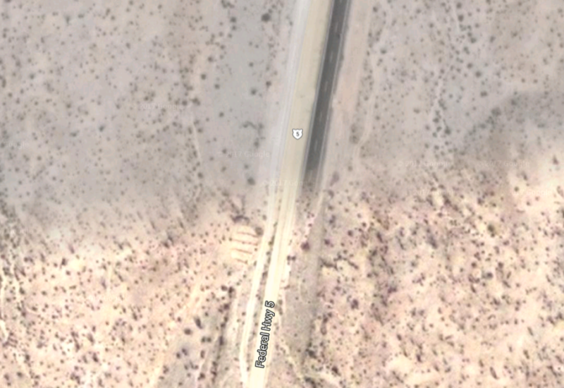
Hummm ... yes. As a test, I looked at Highway 5 pavement progress and you can see pavement to 7.3 miles south of Gonzaga - this is where the sat
images have not been updated.
|
|
|
freediverbrian
Senior Nomad
Posts: 615
Registered: 2-24-2007
Location: Papas Gonzaga Bay
Member Is Offline
|
|
Can tell by my new solar panels and a nieghbors house not started, in Gonzaga the imagery is about six to nine months old
|
|
|
RnR
Senior Nomad
Posts: 836
Registered: 5-1-2010
Member Is Offline
|
|
Looks like the imagery date for Gonzaga Bay is April 29, 2016.
|
|
|
yumawill
Nomad
Posts: 103
Registered: 10-11-2016
Member Is Offline
|
|
good roads bring bad people. maybe we should recycle some asphalt.
|
|
|
mtgoat666
Select Nomad
Posts: 17341
Registered: 9-16-2006
Location: San Diego
Member Is Offline
Mood: Hot n spicy
|
|
Actually, Trump arose from stupid voters. You can't blame the good roads.
[Edited on 2-5-2017 by mtgoat666]
|
|
|
imlost
Nomad
Posts: 217
Registered: 3-31-2015
Location: PNW & East Cape
Member Is Offline
|
|
I noticed that for Google Earth in Baja Sur, it shows the old imagery untill you zoom way in, and then it shows really recent, high-detail images.
It's interesting, because you can compare the old to new, so you can see recent development/changes.
|
|
|
PaulW
Ultra Nomad
Posts: 3009
Registered: 5-21-2013
Member Is Offline
|
|
Correct image is not very up to date. The image is 2/26/2005. Just updated my GE and the image is still the same date.
====== ==
Quote: Originally posted by StuckSucks  | Hummm ... yes. As a test, I looked at Highway 5 pavement progress and you can see pavement to 7.3 miles south of Gonzaga - this is where the sat
images have not been updated.
|
|
|
|
StuckSucks
Super Nomad
Posts: 2307
Registered: 10-17-2013
Member Is Offline
|
|
| Quote: Originally posted by PaulW | Correct image is not very up to date. The image is 2/26/2005. Just updated my GE and the image is still the same date.
====== ==
| Quote: Originally posted by StuckSucks | | Hummm ... yes. As a test, I looked at Highway 5 pavement progress and you can see pavement to 7.3 miles south of Gonzaga - this is where the sat
images have not been updated. |
|
But there was no pavement 7 miles south of Gonzaga in 2005, right? Seems the date must be wrong or something?
|
|
|
imlost
Nomad
Posts: 217
Registered: 3-31-2015
Location: PNW & East Cape
Member Is Offline
|
|
If you're unsure your Google Earth app is up-to-date, then just go to Google Maps at https://www.google.com/maps , and click on the "Earth" button in the lower-left corner. This should display the latest/greatest. You'll want to
zoom in all the way for the latest image. For Baja Sur, they're still showing an older image for the wide area view.
[Edited on 2-6-2017 by imlost]
[Edited on 2-6-2017 by imlost]
|
|
|
DavidT
Nomad
Posts: 494
Registered: 4-9-2005
Member Is Offline
|
|
| Quote: Originally posted by imlost | | I noticed that for Google Earth in Baja Sur, it shows the old imagery untill you zoom way in, and then it shows really recent, high-detail images.
It's interesting, because you can compare the old to new, so you can see recent development/changes. |
Same with Punta Bufeo above Gonzaga Bay, the buildings and area immediately surrounding them are recent. Offshore and inland are older images.
Interesting article about some of the new satellites coming online.
Planet
David
Not one shred of evidence supports the notion that life is serious.
|
|
|
unbob
Nomad
Posts: 407
Registered: 8-7-2006
Member Is Offline
|
|
More re Planet, Inc.:
"... a 50-trillion-pixel image of Earth, refreshed daily, is coming later this year."
"It will photograph every place on the entire planet every day. Every park, every rice paddy, every patch of pine and permafrost: all will be
imaged anew, daily, at medium resolution."
WOW!!!
https://www.theatlantic.com/technology/archive/2017/02/googl...
"I'm too young to be this old!"
|
|
|
David K
Honored Nomad
Posts: 64493
Registered: 8-30-2002
Location: San Diego County
Member Is Offline
Mood: Have Baja Fever
|
|
Oh wow... can you imagine!
In 2005, the pavement wasn't even to Puertecitos! It was there from the 1990s, but so thin it dissolved by 2000, at least near Puertecitos.
They began the new, good highway south of Puertecitos in 2007 and averaged about 8 miles a year until just before 2014, when pavement progress halted
20 kms. south of the Gonzaga Pemex. Crews concentrated on tearing down the mountain range and passing through the beautiful granite boulders of Las
Arrastras, where the new highway was to go. Just last month, they were still using dynamite to blast the granite boulders only a couple miles south of
the end of pavement.
|
|
|


