| Pages:
1
2
3 |
Chucho
Newbie
Posts: 7
Registered: 2-6-2017
Member Is Offline
|
|
Milke's to Rancho Meling to Observatorio
New to this forum - this is my first post actually.
Some friends and I are going to the Observatorio later this month, and we were thinking about driving from Mike's to PN via Rancho Meling.
Is there an actual road, or just single track motorcycle trails ? Is 4x4 required?
Thanks!
Chucho
|
|
|
ehall
Super Nomad

Posts: 1906
Registered: 3-29-2014
Location: Buckeye, Az
Member Is Offline
Mood: It's 5 o'clock somewhere
|
|
Jeep trail. Haven't heard anyone lately reporting on the shape it is in.
|
|
|
ztrab
Junior Nomad
Posts: 46
Registered: 2-16-2005
Member Is Offline
|
|
North of the observatory road, look for the dirt road to Ranch Coyote, it's just west of the Meling Ranch. About 7 miles of graded dirt road to
Coyote. At the ranch turn the road continues north a short distance to a cattle guard and two gates , enter and travel east on the road. Subject to
weather damage, you can reach Mikes in a 4x4, nothing too technical, it is well used by motorcycles, so keep your lights on and eyes up. Its about
11.2 miles from the gate to Mike's. I have a track if you need it, not sure how to post it here.
|
|
|
Chucho
Newbie
Posts: 7
Registered: 2-6-2017
Member Is Offline
|
|
Quote: Originally posted by ztrab  | North of the observatory road, look for the dirt road to Ranch Coyote, it's just west of the Meling Ranch. About 7 miles of graded dirt road to
Coyote. At the ranch turn the road continues north a short distance to a cattle guard and two gates , enter and travel east on the road. Subject to
weather damage, you can reach Mikes in a 4x4, nothing too technical, it is well used by motorcycles, so keep your lights on and eyes up. Its about
11.2 miles from the gate to Mike's. I have a track if you need it, not sure how to post it here.
|
Thanks for the offer ztrab. I just sent you a private U2U with my email address.
For this route, is 4x4 needed? My friend's truck is not 4x4 - mine is though.
Chucho
For this trip, I will be driving my 4x4 Tundra but my friend's
|
|
|
bajatrailrider
Super Nomad
Posts: 2423
Registered: 1-24-2015
Location: Mexico
Member Is Offline
Mood: Happy
|
|
There are some wash outs from Coyotes to Mikes. If you get to Coyotes go in back See Mike.He rides this area on Moto knows road cond.Yes on you need
4x4.
|
|
|
David K
Honored Nomad
Posts: 64476
Registered: 8-30-2002
Location: San Diego County
Member Is Offline
Mood: Have Baja Fever
|
|
4WD is the recommedation, mostly for the huge grade just south of Mike's. It is not the normal route in for many years.
|
|
|
Chucho
Newbie
Posts: 7
Registered: 2-6-2017
Member Is Offline
|
|
Thanks all for your responses and recommendations. It seems like 4X4 is a must from Mike's to Meling and then Observatorio...
Any other route (other than the highway) from Laguna Hanson to Observatorio that can be done on a 2WD truck?
Chucho
|
|
|
ehall
Super Nomad
Posts: 1906
Registered: 3-29-2014
Location: Buckeye, Az
Member Is Offline
Mood: It's 5 o'clock somewhere
|
|
Dirt road from Valle de Trinidad to hwy 1. Easily done in a 2wd and very scenic. Cuts off lots of highway miles.
|
|
|
David K
Honored Nomad
Posts: 64476
Registered: 8-30-2002
Location: San Diego County
Member Is Offline
Mood: Have Baja Fever
|
|
| Quote: Originally posted by ehall | | Dirt road from Valle de Trinidad to hwy 1. Easily done in a 2wd and very scenic. Cuts off lots of highway miles. |
This is the road that hits Hwy. 1 just south of San Vicente in the grape vineyards.
Go south to the observatory highway at San Telmo de Abajo, between Colonet and Camalu. 62 paved miles to the observatory at 9,280 ft. What a rush that
drive is!
[Edited on 2-9-2017 by David K]
|
|
|
TMW
Select Nomad
Posts: 10659
Registered: 9-1-2003
Location: Bakersfield, CA
Member Is Offline
|
|
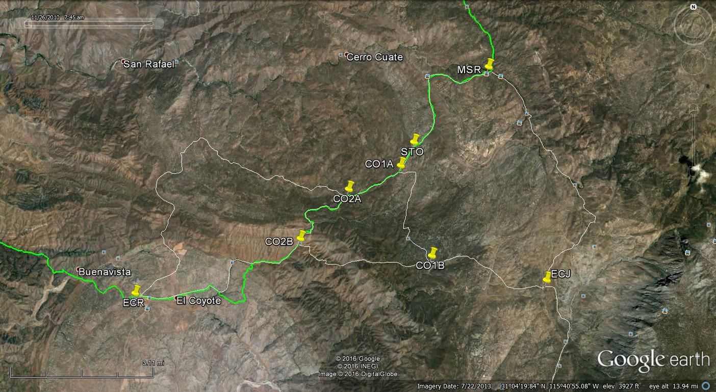
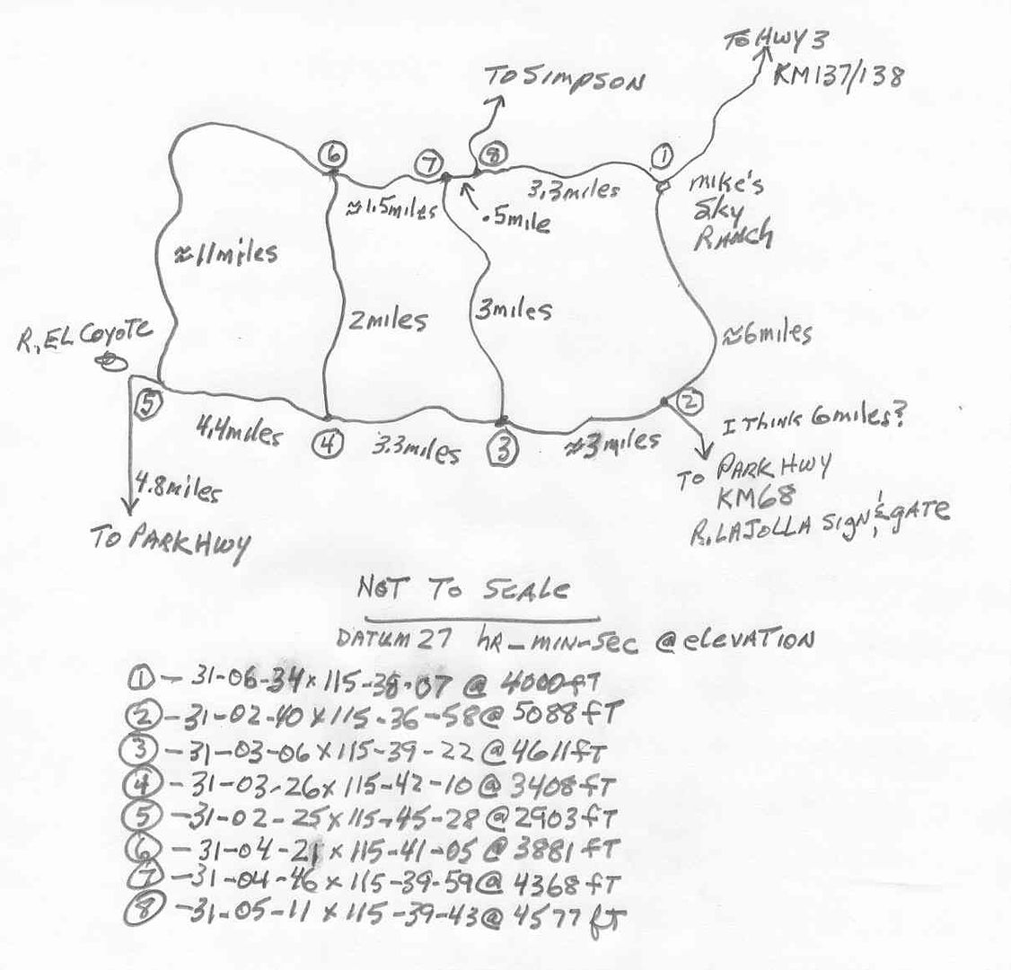
Here is a Google Earth image of the roads between El Coyote and Mikes Sky Ranch. The green line is the Baja 1000 race course , I think from 2013.
Here is a hand drawing I did several years ago. Note the GPS readings are in Hours, minutes and seconds. My wife and I drove all the roads. The lower
right road went to Dark Skies Baja or what ever it was called, owned by Mike and Pamala then.
|
|
|
Mexitron
Ultra Nomad
Posts: 3397
Registered: 9-21-2003
Location: Fort Worth, Texas
Member Is Offline
Mood: Happy!
|
|
Only thing I would add is that road between R. Coyote and Mike's washes out pretty badly in rainy years. One year (1997?) it took us 8 hours to get
through and I crunched the side of my truck on an oak tree--not for the faint of heart. Other times its been a breeze. Keep checking for info since
the rains have been heavy at times this year.
|
|
|
ehall
Super Nomad
Posts: 1906
Registered: 3-29-2014
Location: Buckeye, Az
Member Is Offline
Mood: It's 5 o'clock somewhere
|
|
The road from MSR to dark sky was too much for my jeep. Off camber and washed out . forced to turn around after backing uphill on a shelf road for 1/4
mile.
|
|
|
TMW
Select Nomad
Posts: 10659
Registered: 9-1-2003
Location: Bakersfield, CA
Member Is Offline
|
|
I believe the last time SCORE used the route from Mikes to Dark Skies was 2002 and the last time they used the route from the Dark Skies turnoff to
Mikes was 2003. In the 2003 race there was a hill the racers went up between 4 and 3 that became a silt bed nightmare and many 4 wheel racers ended
their race there. Later that year is when I did the hand drawing above. Sometime after 2003 rains did a lot of damage to it.
When the route was open from Mikes to Dark Skies the owners closed it off to racing and to thru traffic after the thru traffic was trashing the route.
They locked the gate where it meets the Observatory road.
|
|
|
Elena La Loca
Nomad
Posts: 143
Registered: 8-31-2003
Location: Oceanside, CA
Member Is Offline
|
|
Rumor has it that my girlie jeep made that route back in the day but I wasn't there.
Are we ever really "there"?
Heard it's a double chonie changer but then they call me "chicken' for a reason.
|
|
|
Elena La Loca
Nomad
Posts: 143
Registered: 8-31-2003
Location: Oceanside, CA
Member Is Offline
|
|
Oh yeah. forgot to add that WB makes that map in his daily driver.
But that's WB, right?
|
|
|
PaulW
Ultra Nomad
Posts: 3004
Registered: 5-21-2013
Member Is Offline
|
|
We followed your green line MSR to Coyote as far as just past CO2B where you see a faint non-green road toward Coyote. That faint road is just in the
general area as the new road the Coyote people had recently made with a bulldozer and the road was very good. The new road led down the hill and
bypassed the big rancho on my right and then intersected an existing road to the rancho and then directly to Coyote thru the horse corral. After
arriving at Coyote we had a long discussion with Mike and he said that all other roads were devastated and not passable with even his trail bike. That
was last Jan or Feb after those heavy rains.
Having said all that, It is hard to believe that those roads on your sketch have not been opened up after a year.
I guess it is time to drive some roads.
====== =
mTo | Quote: Originally posted by TMW | Here is a Google Earth image of the roads between El Coyote and Mikes Sky Ranch. The green line is the Baja 1000 race course , I think from 2013.
Here is a hand drawing I did several years ago. Note the GPS readings are in Hours, minutes and seconds. My wife and I drove all the roads. The lower
right road went to Dark Skies Baja or what ever it was called, owned by Mike and Pamala then.
|
[Edited on 2-9-2017 by PaulW]
|
|
|
bajatrailrider
Super Nomad
Posts: 2423
Registered: 1-24-2015
Location: Mexico
Member Is Offline
Mood: Happy
|
|
The road from Mikes to Coyote without 4x4 no go.With recent rains maybe not passable. If you need current update send me PM,as I have Friend that
lives there. On dirt bikes a blast On dirt bikes a blast
|
|
|
BigBearRider
Super Nomad
Posts: 1299
Registered: 4-30-2015
Location: Big Bear, Punta Chivato, and Cabo
Member Is Offline
Mood:
|
|
I took the pavement from Mex 1 to Meling on Feb 18th. The first part, before gaining elevation, had a fair amount of smaller rocks, sand, and other
debris washed over it, requiring care to be taken.
Past Meling, the road was good up until about 20 kms from the Observatory, where the snow was getting to be heavy. I saw six condors perched along
the way. Park Rangers came down the mountain and said the road was closed. They locked the gate. I told them I had 4x4 and chains, but they said no
access was permitted.
|
|
|
TeamDonde
Junior Nomad
Posts: 28
Registered: 4-2-2011
Member Is Offline
|
|
Having just returned I can advise to NOT take a vehicle through from Mikes south toward El Coyote. Its beat up enough that it would take hours and
hours to do it IF you were able to not end up swallowed by a rut.
|
|
|
PaulW
Ultra Nomad
Posts: 3004
Registered: 5-21-2013
Member Is Offline
|
|
Repeating my previous post.
The road from Mikes to Coyote can be done easily with high clearance rig, but no need for 4wd. That hard place is at the Mikes end going up the hill.
The critical part is road selection. Do not plan on using many of the roads that Tom (TMW) posted. There is a new road made last year by the People at
Coyote that bypasses the devastation. Easy road down the hill to an existing road used by an adjacent ranch. We were lucky because we saw the small
sign that said to turn off the main road to avoid the washouts.
Follow the green line to CO2B. The new road is after CO2B. Keep right not straight.
|
|
|
| Pages:
1
2
3 |


