PaulW
Ultra Nomad

Posts: 3009
Registered: 5-21-2013
Member Is Offline
|
|
Pole line alternate routes
It has become very obvious that the rancher does not want us to drive from the bottom of the summit onto his ranch. I am sure he is darn mad that we
passed thru that fenced area.
So as most of you know the pole line track and the parallel road went over the Jamau summit (south summit) and followed the road and washes all the
way to Chinero and then to San Felipe somewhere near the present Hwy5
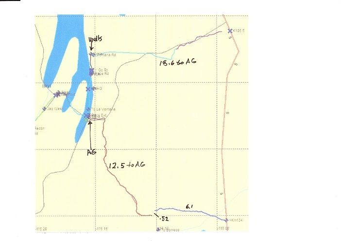
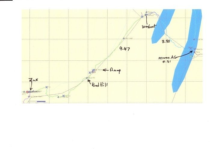
Here are some actual one way GPS miles. Go out and back, so double the miles or mix and match for your trip.
From the ElDorado North PMEX to Chinero at Km135 =34 miles
K134- Pinta Pass east = 6.1
PPeast crossover to PPwest = 0.52
PPWest to Arroyo Grande = 12.5
Crossover AG = 0.31
AG to the off camber washout* = 3.85
Washout* to Zuk turn = 9.47
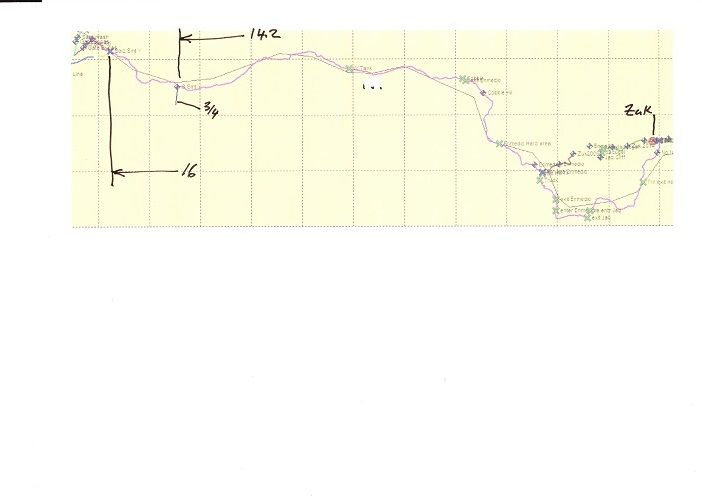
Zuk turn to Siaz Summit "Y" =16 (I would not want to go closer to the new fence).
Total 82.75 miles
Alternatively From the Hwy5 Km31 Pmex to La Ventana = 46.9
La Ventana to Arroyo Grande turn to the PLR = 18.6
AG to the off camber washout* = 3.85
Washout* to Zuk turn = 9.47
Zuk turn to Siaz Summit "Y" =16
Total 94.82 miles
* washout is where we make the double U turn to first enter Jaquegel before the Wash entry.
Option turn at the Jamau Summit “Y”
The 16 mi above becomes 14.2 miles
And the leg toward Jamau summit is about ¾ mile. (Not driven)
= = = =
Screen shot to match PLR tracks
Hwy5 to AG
AG to Washout
Zuk to Siaz Y
[Edited on 2-24-2017 by PaulW]
|
|
|
David K
Honored Nomad
Posts: 64493
Registered: 8-30-2002
Location: San Diego County
Member Is Offline
Mood: Have Baja Fever
|
|
Paul... a map with your named locations pointed out would be great.
The good news, as of 10 am today, we know that Jeeps made it to the telephone pole lined mesa ("Bad Hill") heading east [see the 3.8 mile section in
the first map, or "Many Poles" section on the second map, below].
As soon as Ken posts more, we will know if they made it all the way to Arroyo Grande... and out to La Ventana.
Some maps:
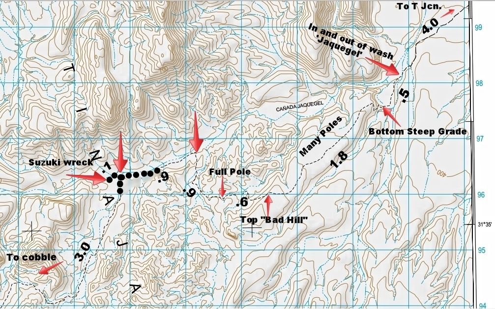
Mileages between arrow points.
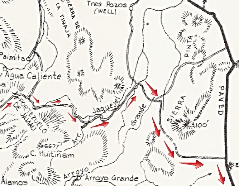
1962 map with Pole Line run from The Summit to El Chinero.
|
|
|
PaulW
Ultra Nomad
Posts: 3009
Registered: 5-21-2013
Member Is Offline
|
|
Go back to original post for pics
|
|
|
Ken Cooke
Elite Nomad
Posts: 8921
Registered: 2-9-2004
Location: Riverside, CA
Member Is Offline
Mood: Black Trans Lives Matter
|
|
Quote: Originally posted by David K  |
As soon as Ken posts more, we will know if they made it all the way to Arroyo Grande... and out to La Ventana.
|
I would have posted sooner, had the hotel we stayed at had WiFi. But, when you're only paying $30/night, and you have a nice garage, I wasn't
complaining.
|
|
|
4x4abc
Ultra Nomad
Posts: 4170
Registered: 4-24-2009
Location: La Paz, BCS
Member Is Offline
Mood: happy - always
|
|
the alternative for Cyn Saiz is as old as the Pole Line Road (yellow/green lines in the picture)
first part, coming from the north, follows the wash - so you may have to improvise, but there is plenty of open space
then it follows a well established dirt road that connects to the usually travelled route just 0.4 miles east of the water tower (did you guys never
see the intersection?)
I spotted it 30 years ago - drove it a few times since
3 miles in from the tank you'll find an old airstrip (part of that water line, water tank development)
for the adventurous among you, there is a faint dirt track leading to that airstrip as well
who is gonna bring the first pictures?
GPS here: http://baja101.com/Baja-GPS/PLRalt.kmz

Harald Pietschmann
|
|
|
David K
Honored Nomad
Posts: 64493
Registered: 8-30-2002
Location: San Diego County
Member Is Offline
Mood: Have Baja Fever
|
|
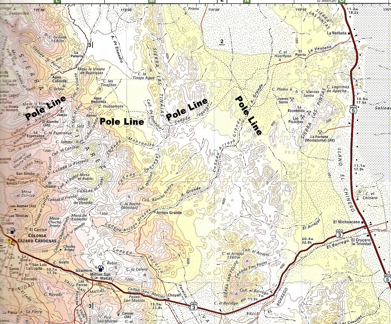
Neal Johns mapped that other road in to near the water tank.
I will add his map later.
Harald, have you seen Campo la Victoria, out there?
Here it is on the 1974 Auto Club map:
|
|
|
4x4abc
Ultra Nomad
Posts: 4170
Registered: 4-24-2009
Location: La Paz, BCS
Member Is Offline
Mood: happy - always
|
|
yes, I have been to La Victoria - cool airstrip nearby
a total of 6 airstrips in that valley
Harald Pietschmann
|
|
|
PaulW
Ultra Nomad
Posts: 3009
Registered: 5-21-2013
Member Is Offline
|
|
| Quote: Originally posted by 4x4abc | the alternative for Cyn Saiz is as old as the Pole Line Road (yellow/green lines in the picture)
first part, coming from the north, follows the wash - so you may have to improvise, but there is plenty of open space
then it follows a well established dirt road that connects to the usually travelled route just 0.4 miles east of the water tower (did you guys never
see the intersection?)
I spotted it 30 years ago - drove it a few times since
3 miles in from the tank you'll find an old airstrip (part of that water line, water tank development)
for the adventurous among you, there is a faint dirt track leading to that airstrip as well
who is gonna bring the first pictures?
===
Harald, Good info. In answer to your question - I did not see that path (yellow/green). Tempting to drive up there and explore that area. Need to slow
down and pay attention to what is on the road side. |
|
|
|
Ken Cooke
Elite Nomad
Posts: 8921
Registered: 2-9-2004
Location: Riverside, CA
Member Is Offline
Mood: Black Trans Lives Matter
|
|
| Quote: Originally posted by 4x4abc | the alternative for Cyn Saiz is as old as the Pole Line Road (yellow/green lines in the picture)
first part, coming from the north, follows the wash - so you may have to improvise, but there is plenty of open space. |
Great work, Harald! This looks like the future route of the Pole Line Road
I am already in contact with another Mexicali club regarding these changes. They plan to run the Pole Line Road on March 4th.
|
|
|
David K
Honored Nomad
Posts: 64493
Registered: 8-30-2002
Location: San Diego County
Member Is Offline
Mood: Have Baja Fever
|
|
Neal Johns Notes on Map
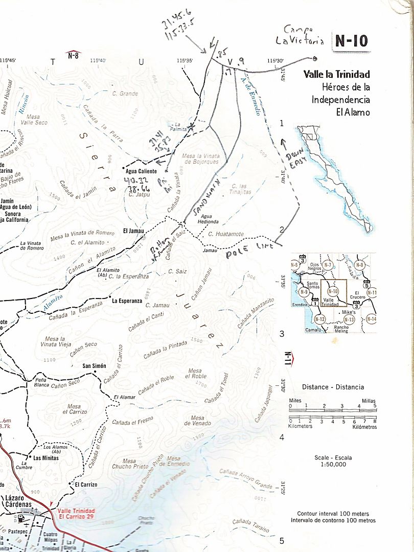
Here are what the notes say, if not clear on map:
At the top, the arrow is the road from Laguna Salada/ Cohabuzo Jcn.
The jog is 0.85 mi. from a dead end road (indicated to La Palmita) to the next parallel road south. That goes (using right fork/ dashed line to a Pai
Pai Indian village and Agua Caliente hot spring area). The left fork goes to the bottom of the summit and the traditional start of the Pole Line Run.
Abbreviated GPS figures are for Lat 31° and Lon -115°, and are Map Datum NAD27 Mexico, as that was what the Baja Almanac used.
The next junction, heading east, at the top of the map, is 0.7 mi. and that is the road south to the summit bottom/ Pole Line Road run start. Note
along it says "Sand Wash". At the end, the note says, "Bottom of Summit".
The final junction heading east on the top of the map is 0.9 mi. further and this is the long, dashed line with a note "Down Easy" along it. This
joins the Pole Line Road near the water tank.
The east road (at the map top) continues to Campo La Victoria.
In conclusion, if the "Down Easy" road is open and passable, this gives access to the Pole Line Road far east of the rancher and his fences and gates.
|
|
|
Ken Cooke
Elite Nomad
Posts: 8921
Registered: 2-9-2004
Location: Riverside, CA
Member Is Offline
Mood: Black Trans Lives Matter
|
|
| Quote: Originally posted by David K |
In conclusion, if the "Down Easy" road is open and passable, this gives access to the Pole Line Road far east of the rancher and his fences and gates.
|
I advised a Mexicali-based 4 Wheel Drive club to bypass the very first part of the trail, and exit at the White Tank. His club took the route in from
La Ventana, going UP the "Bad Hill" as part of the challenge!
|
|
|
David K
Honored Nomad
Posts: 64493
Registered: 8-30-2002
Location: San Diego County
Member Is Offline
Mood: Have Baja Fever
|
|
Great!
|
|
|
Ken Cooke
Elite Nomad
Posts: 8921
Registered: 2-9-2004
Location: Riverside, CA
Member Is Offline
Mood: Black Trans Lives Matter
|
|
No cows were harmed on the Pole Line Road by the Animals Baja 4WD CLUB Mexicali
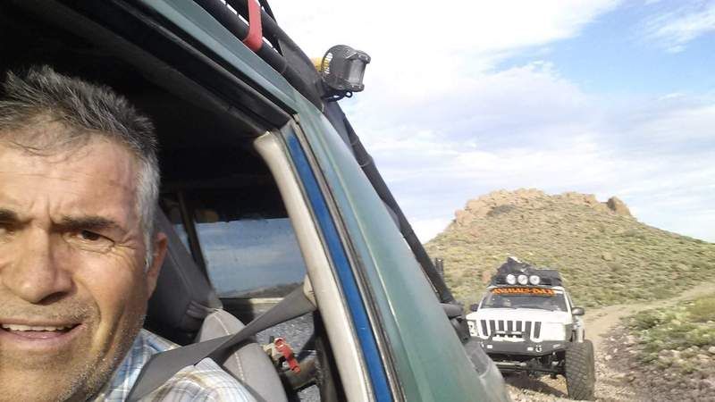
[Edited on 3-6-2017 by Ken Cooke]
|
|
|
PaulW
Ultra Nomad
Posts: 3009
Registered: 5-21-2013
Member Is Offline
|
|
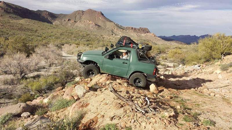
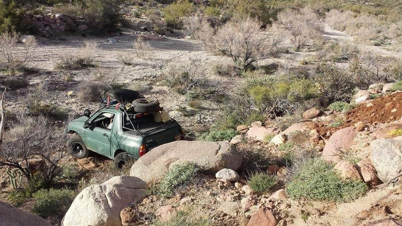
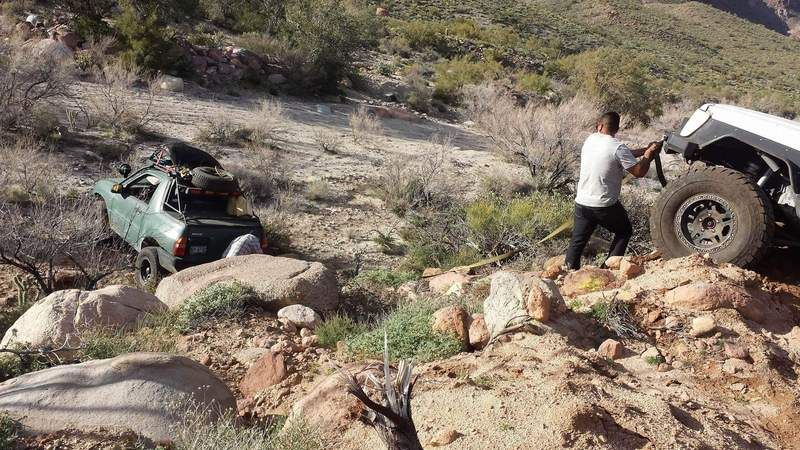
Ha - I thought about driving down that place into Siaz wash. I know the Bronco would have made it down, but getting backup would have been an issue.
My skids would not have survived those rocks. The Jeep guys we were with agreed that that descent was not a good idea.
|
|
|
David K
Honored Nomad
Posts: 64493
Registered: 8-30-2002
Location: San Diego County
Member Is Offline
Mood: Have Baja Fever
|
|
You should have seen the metal scraping I left just getting near the Matomi narrows, 2 days ago! The tv size boulders finally halted my progress.
Photos when I am home. It sure changed this winter, as have so many roads I was on this season!
|
|
|
Ken Cooke
Elite Nomad
Posts: 8921
Registered: 2-9-2004
Location: Riverside, CA
Member Is Offline
Mood: Black Trans Lives Matter
|
|
| Quote: Originally posted by PaulW | | Ha - I thought about driving down that place into Siaz wash. I know the Bronco would have made it down, but getting backup would have been an issue.
My skids would not have survived those rocks. The Jeep guys we were with agreed that that descent was not a good idea. |
If you see the Rancher in your rear view, you can lose him on this hill!
|
|
|
PaulW
Ultra Nomad
Posts: 3009
Registered: 5-21-2013
Member Is Offline
|
|
The trip up to the race summit was a bust , but I did take a few pics.
Pics are from the race summit looking toward the PLR.
Some of the roads that intersect the PLR are visible.
The Lock gate and new fence are not visible
Otherwise study up for our next adventure
    
|
|
|
Ken Cooke
Elite Nomad
Posts: 8921
Registered: 2-9-2004
Location: Riverside, CA
Member Is Offline
Mood: Black Trans Lives Matter
|
|
Why was your trip up the summit a bust? The 4x4 Baja Animals made it up to the Laguna Hanson last weekend..
|
|
|
PaulW
Ultra Nomad
Posts: 3009
Registered: 5-21-2013
Member Is Offline
|
|
Ken, By a bust I mean the road was very tiring . Lots of bump bump all the way up and back. I was also discouraged by all the new road damage.
I ran 15 psi and it still was a lot of bouncing.
|
|
|


