David K
Honored Nomad

Posts: 64476
Registered: 8-30-2002
Location: San Diego County
Member Is Offline
Mood: Have Baja Fever
|
|
2017 Baja Expeditions: Project Outline
To bring everyone up-to-speed:
In 2017, I have begun to retravel roads from my past and travel roads I have not yet been on. Here are the regions of info gathering done to date:
Trip 1, New Years 2017: SanFelipe to Punta San Francisquito
Trip 2, Feb. 2017: San Ignacio to Loreto area + San Javier, Comondu, La Purisima, San Borja.
Trip 3, March 2017: Mexicali to San Felipe, San Pedro Martir canyons, Laguna Chapala north to San Quintin.
All this to document the conditions and report on places Baja travelers may enjoy seeing or staying at. The data (which includes location GPS, photos,
observed conditions, history, etc.) will be available online via a "living map" as well as printable versions that would be a road log. That is all
yet to be determined based on the requests we get.
The Baja Almanac is still the best all-road map, even though it is almost 8 years old. The AAA map was last reprinted in 2010 and the only new data
was gathered from the three maps of 2003, 2004, and 2007.
Traveling to and throughout Baja is what we all like. But, so many of us find a spot.... and then keep going to that same spot! Guidebooks and maps
give us a hint of what's over that hill or across that salt flat and can open up new areas of fun and potentially provide economic growth to locals. I
have many Baja friends and one thing we all share is an interest in exploring. We know a road on a map is just a line, or a photo is just a hint, and
words can never fully describe how each of us will react to any one location. Guidebooks and maps do not spoil the thrill or take away the personal
discovery one has. If you just don't want any clue about where a road goes, simple... don't read my trip report or get the map-guide!
To travel that line on a map and experience that road is as much fun for some as where the road ends up going. Baja is a land of many roads... and
they all go somewhere! Most of the time, they go somewhere interesting and fun.
Trip reports here on Baja Nomad are the greatest, and often a most important feature to all Baja travelers. However, searching for a trip report to
the area you want to read about is not easy for many. The same question is asked, that may have been answered a couple days earlier.
My sharing my trips here on Nomad creates feedback if: the road changed, or the restaurant got a new cook, or I missed a nice beach because the tide
was too high, and so on! Now, with this new data, we can update the map-guide to everyone's benefit. If you don't need the guide, then don't look at
it, but just remember a guide of some sort was how ALL of us learned about Baja or got us to go there. The "guide" may have been a story from a
friend, an article in a magazine, or a book... maybe your mom or dad dragged you there as a kid, and you became addicted to this magic peninsula?
Hank and Geoff of Baja Bound Insurance (as well as their staff) have agreed with me about a need for an updated map/guide. Hank and I
talked about the idea over 15 years ago. Now, with the technology and Internet expertise available we are creating a map that will have hundreds of
waypoints that can be clicked on, and that will open up info about that place. It may include photos and comments. Being online, this "living map" can
be updated as conditions change or data needs correcting. All of you can contribute to keeping the information fresh and accurate.
A road log is being created that utilized kilometer markers (where possible) to easily find a turnoff, taco stand, or motel. This way, the doing math
with your odometer to find a point is reduced, as well as the issue of odometers not all reading the same, especially when we put on oversize tires!
Before your trip, just print the part of the road log you need or the map area. The possibility of publishing (printing) these, is always an option.
Let's see how things progress. I look forward to your positive feedback and constructive criticism to make this a more beneficial project for both
travelers who are "Baja Bound" and for the people who live and work in Baja California.
This next report will be of trip #3 for this project. This year, so far, I have travel 4,000 miles for information gathering for the Baja Bound
Map-Guide. It won't cover all roads in Baja or all the great places, there are just too many! I do hope to travel all the roads that go to places that
sound or are known to be interesting or special.
A few roads will require four-wheel drive, off-road driving skill, or deflating tires for improved traction. They will be listed as 4WD only or 4WD
recommended. Naturally, some of us can get into places with 2WD that others wouldn't attempt or don't mind spinning tires or some rock damage. My job
is to report and you can decide to go or not. As most of you know, I use a 4 door Tacoma 4WD truck that is almost stock. Just a small lift and 1"
taller than stock tires. I travel alone, so I won't take a road that could require a buddy along to spot my tire placement or pull free from a rock
high center (hopefully).
A few places included will be for hikers, but not far if you have 4WD. Now, a message for the special group here who like to surf: I personally won't
be listing anybody's surf location recommendations or directing people to the surfing breaks. There are already maps and surfing guidebooks that do
that.
OKAY AMIGOS?
FOLLOW ME TO BAJA!
Trip 3 photos and notes coming next!
|
|
|
TMW
Select Nomad
Posts: 10659
Registered: 9-1-2003
Location: Bakersfield, CA
Member Is Offline
|
|
Excellent David. I have traveled Baja and Baja Sur since 1978 and I do often go to the same places. I also read about a place I would like to see and
think gee I was near there and didn't stop. I think the information you will provide will make me more aware of those places or stops and hopefully I
will not pass them by, like that corral I told you about.
|
|
|
Barry A.
Select Nomad
Posts: 10007
Registered: 11-30-2003
Location: Redding, Northern CA
Member Is Offline
Mood: optimistic
|
|
What a great and helpful project, David. Kudos to you for taking this on (tho I KNOW you love doing it). (-:
|
|
|
chavycha
Nomad
Posts: 373
Registered: 1-20-2014
Member Is Offline
|
|
Awesome. Your maps are a huge help here on the forum - will be great to have them available to a wider audience.
|
|
|
blackwolfmt
Senior Nomad
Posts: 802
Registered: 1-18-2014
Location: On The Beach With A Blackwolf
Member Is Offline
Mood: dreamin of Riden out a hurricane in Baja
|
|
lkn fwd too the trip DK!!
So understand dont waste your time always searching for those wasted years
face up and make your stand and realize that your living in the golden years
|
|
|
kevin_in_idaho
Nomad
Posts: 143
Registered: 12-13-2016
Member Is Offline
|
|
Very cool. I think I sent you my last trip report but I'm sure you've been to all the places I went.
Great idea. I'd be more than willing to help you out in any way I can. I just can't get to Baja very easily as I'm in Idaho :-(
|
|
|
David K
Honored Nomad
Posts: 64476
Registered: 8-30-2002
Location: San Diego County
Member Is Offline
Mood: Have Baja Fever
|
|
Great, a Nomad group effort. Thank you for the possitive feedback!
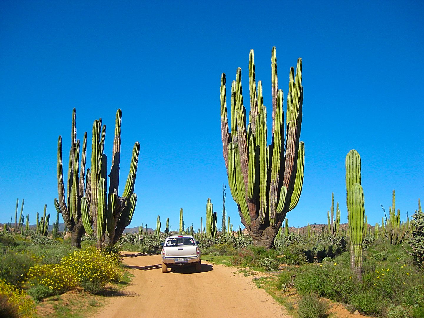
On my second night camping, I either began to get a cold or allergies were going crazy! I opted to continue my research in another region so I could
get good night's sleep at Baja Cactus Motel, El Rosario.
The desert is green and alive with flowers everywhere. My eyes watered, my sinuses blocked, Sudafed didn't help nor did some that Antonio gave me.
However, I still spent hours exploring and mapping. Got home last night, still congested. Doctor appointment tomorrow!
I hope the photos show the colors well! Coming soon!
|
|
|
KurtG
Super Nomad
Posts: 1201
Registered: 1-27-2004
Location: California Central Coast
Member Is Offline
Mood: Press On Regardless!!
|
|
This is a great project. I have a couple of old trip logs with gps coordinates and will take notes on my trips of the next two weeks and forward them
to you for use if they fit with your efforts.
|
|
|
David K
Honored Nomad
Posts: 64476
Registered: 8-30-2002
Location: San Diego County
Member Is Offline
Mood: Have Baja Fever
|
|
Thank you, Kurt.
I am only able (time-wise) to do the main roads most Baja travelers would use to get to destinations. However, I am adding a few for off-roaders (and
maybe 2WDs) that go to special points of interest... such as the railroad terminal south of Las Flores. Matomí waterfalls, San Juan de Dios, and
other surprises!
Now, the beauty of this guide is, that being on-line, we can continue to update and ADD more to it! So, if I cannot keep doing it at some point
(getting old sucks), another crazy Baja nut can!
|
|
|
|


