| Pages:
1
2
3
4
5 |
David K
Honored Nomad

Posts: 64480
Registered: 8-30-2002
Location: San Diego County
Member Is Offline
Mood: Have Baja Fever
|
|
Yes, that is the canyon entrance. If you drove in on that road you would soon pass the water tank and come to a gate. At the gate, look to the south
wall of the canyon to see petroglyphs. Open the gate (and close behind you) to continue on. The hot spring is about at 30° 38.877'N, 115° 12.490'W.
I have posted the exact GPS when I was there in my Trip Report from 2004, and in this webpage, I made: http://vivabaja.com/404/
The canyon (all canyons) have gone through some major changes with the dramatic increase in the wetter weather of the past few years. At one time 4x4s
could get all the way to the spring but when I went in 2000 and 2004, a walk of about a mile was required from a point where the road was no longer
there (boulders and brush in the way). Last year, the major washout of the road was as I reported above, but a track was forged through to the left...
I was solo and could not afford to be risky with an almost stock 4x4, to see how far I could get.
|
|
|
PaulW
Ultra Nomad
Posts: 3005
Registered: 5-21-2013
Member Is Offline
|
|
Its been a long long time since I have been up there. Time to add to my to do list. David's coords are accurate and I found the puddle of warm water
to be smaller many years earlier. An attempt was made to continue up the so called road , but the trucks were to big and the track was very overgrown.
Any bike should go much further. Now I use a Jeep so progress may be better? Off and on there have been reports of closure by the owner. No reports
recently. I will ask around and report back
|
|
|
WideAngleWandering
Nomad
Posts: 390
Registered: 3-13-2012
Location: US-Based but traveling
Member Is Offline
|
|
Cool. If I can schedule it right i'd have a second vehicle, but I might have to go solo. Either way I'd like to see how far I can get and maybe hike
in the last bit.
I'll be out that way mid-January.
Traveling the Americas via my old land cruiser
|
|
|
David K
Honored Nomad
Posts: 64480
Registered: 8-30-2002
Location: San Diego County
Member Is Offline
Mood: Have Baja Fever
|
|
In 2004, the hot spring was huge... in the volume of super-hot water it flowed out... at a reported 140°F.
The hot spring alone created a hot water stream (steaming) that flowed for a couple hundred feet in the canyon floor before it merged with the
year-round, cool mountain stream in the center of the arroyo floor... Hot and Cold running water in Baja!
It is just over 3 miles from the canyon entrance to the hot spring. In 2004, we could drive in 2 miles and walked the last mile.
The spring (there was more than one, but the main one) was up on the bench a few feet higher than the arroyo floor, on the right-hand side of the
canyon (when walking in). The hot water flowed for a few feet, then dropped down to the main arroyo level. There was a rock-lined bathing pool at that
point, but the water was WAY TOO HOT to use it. If there was a way to divert the cool stream... about 50 feet away, then that would have been perfect.
I followed the hot stream back down to a point where the water felt to be under 105°F for soaking and made a shallow pool. Rocks prevented from going
too deep.
Here is the page with my 2004 photos plus one sent to me from BajaLou taken from an airplane looking down and east, downstream. I drew in the road
end, hot spring location, and where the marijuana was going to be planted (on the 2000 trip it was being prepared with irrigation lines and fertilizer
bags, brought in by mule or burro).>>> http://vivabaja.com/404/page6.html
Two pages with photos on the hot spring trip in 2000 begin here: http://www.vivabaja.com/baja_2001/page2.html
On to Trip #4: http://forums.bajanomad.com/viewthread.php?tid=86376
[Edited on 4-8-2018 by David K]
|
|
|
David K
Honored Nomad
Posts: 64480
Registered: 8-30-2002
Location: San Diego County
Member Is Offline
Mood: Have Baja Fever
|
|
2017-2018 Baja Bound Road Guide & Map Research Trips
TRIP #1 (San Felipe to Punta San Francisquito via L.A. Bay): http://forums.bajanomad.com/viewthread.php?tid=85374
TRIP #2 (San Ignacio to Loreto, Ligüí, San Javier, Comondú, La Purísima): http://forums.bajanomad.com/viewthread.php?tid=85756
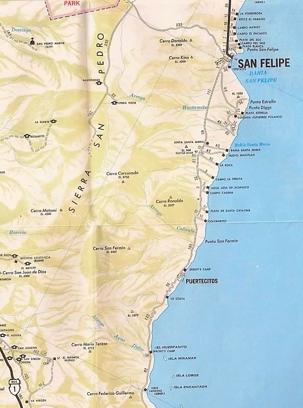
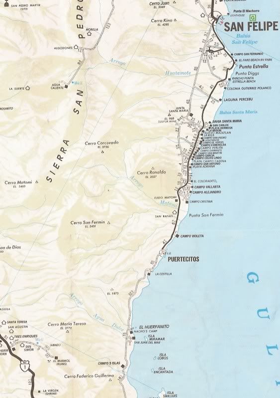
TRIP #3 (Mexicali to San Felipe, Valle Chico, Matomí, Parral, + El Rosario area): http://forums.bajanomad.com/viewthread.php?tid=85989
TRIP #4 (Valle de Trinidad crossover, San Quintin to Laguna Manuela and 7 Sisters coast road): http://forums.bajanomad.com/viewthread.php?tid=86376
TRIP #5 (Central Baja: El Arco, El Barril, San Francisco de la Sierra, Abreojos, Asuncion, Tortugas, Eugenia, Pronghorn Reserve): http://forums.bajanomad.com/viewthread.php?tid=86781
TRIP #6 (Southernmost Baja: San Ignacio to San Juanico, Loreto to Cabo San Lucas, San Evaristo, and more): http://forums.bajanomad.com/viewthread.php?tid=87323
TRIP #7 (Pacific North, San Pedro Mártir Mountains): http://forums.bajanomad.com/viewthread.php?tid=87976
TRIP #8 (Both Hwy. 3's, Hwy. 5 south from 3 Jcn., & Laguna Hanson roads): http://forums.bajanomad.com/viewthread.php?tid=91029
[Edited on 12-3-2018 by David K]
|
|
|
wolfpack
Newbie
Posts: 19
Registered: 9-17-2018
Location: Phoenix, AZ
Member Is Offline
|
|
Great trip report! Is the sulfur mine accessible with a subaru crosstrek? We are going to San Felipe in two weeks for a month and are just getting
into rockhounding and fossil hunting and would love to check these spots out.
If not how far of a hike would it be from parking? We aren't opposed to parking and walking/running 10 miles if that's the only way to see some cool
rocks.
find what you love and let it kill you
|
|
|
David K
Honored Nomad
Posts: 64480
Registered: 8-30-2002
Location: San Diego County
Member Is Offline
Mood: Have Baja Fever
|
|
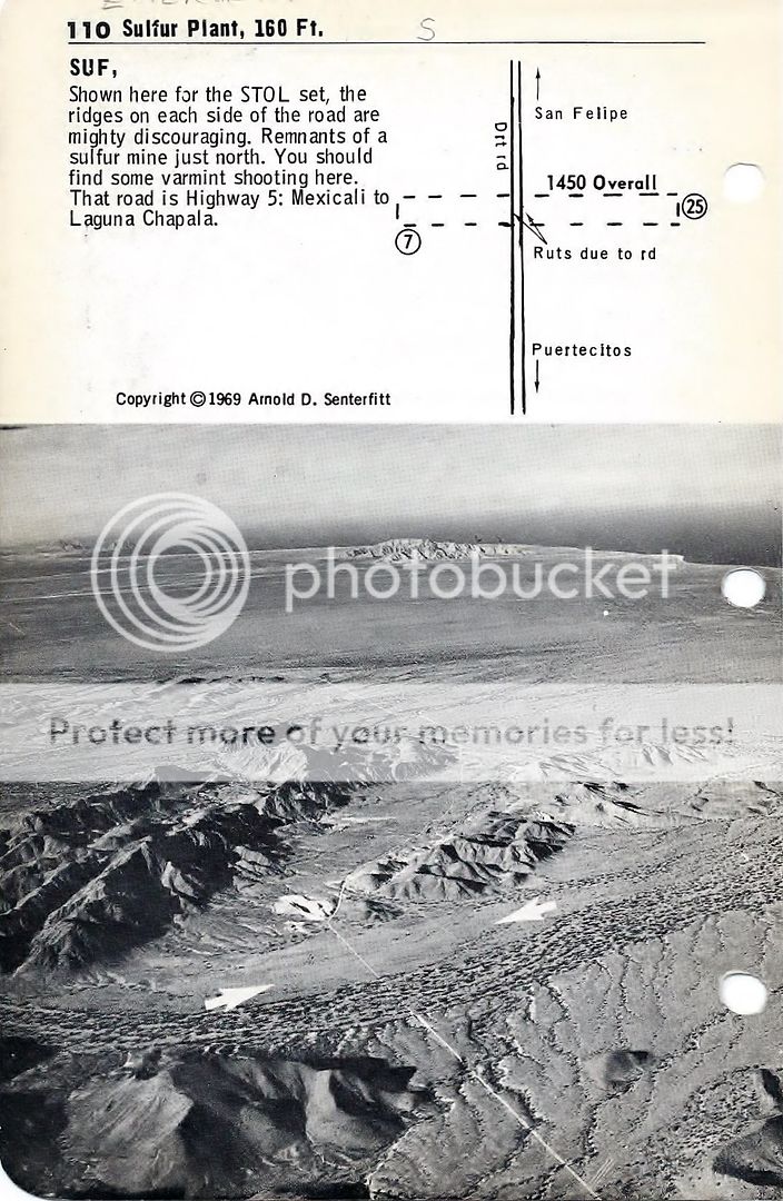
I am not sure what a crosstrek is (I owned 3 Subarus 4WD wagons from 1977-1992), but the road from Hwy. 5 to the sulfur mine valley (which is on the
old Puertecitos road, pre 1983) is a good desert road, about a 4 mile drive from just north of Km. 32.
This was the original 'driveway into Nuevo Mazatlan from the old road/sulfur mine). It may have a high center bit does not need 4WD. Just the old
Puertecitos road is rough and used for the Baja 1000.
Edit... I can help with other fossil and mine sites if you haven't already seen them in my other trip pages.
[Edited on 12-3-2018 by David K]
|
|
|
wolfpack
Newbie
Posts: 19
Registered: 9-17-2018
Location: Phoenix, AZ
Member Is Offline
|
|
The subaru crosstrek is a just cheaper version of the outback. Same clearance - AWD only though.
I looked through trip reports but haven't seen others for rock/fossil sites so would love any direction.
Is google maps accurate for the desert roads? I know in Northern Arizona we have some trouble locating lesser used forest roads at times
find what you love and let it kill you
|
|
|
PaulW
Ultra Nomad
Posts: 3005
Registered: 5-21-2013
Member Is Offline
|
|
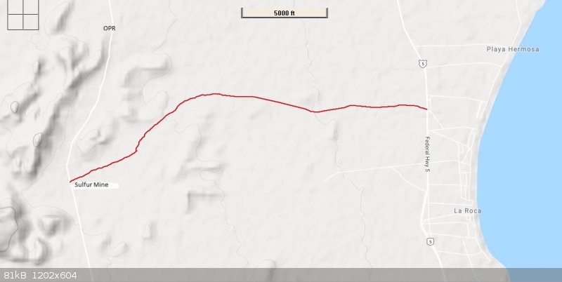
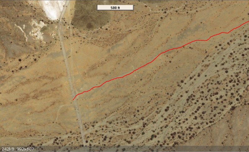
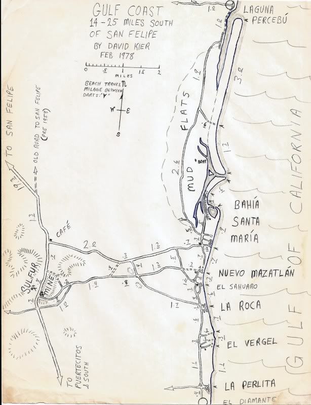
Sulfur Mine and GPS Track
The Mine is located on OPR (Old Puretcitos Road). OPR cannot be traveled in any Subaru. IMO, the track from Highway 5 is doable in a Subaru with tire
pressure at 1/3 of normal and lots of momentum. Once you get to OPR just south of the mine be very careful because the local roads thereabouts are
pretty gnarly.
Google maps does not show back country roads of any kind and will be no help. Same for Maps.me.
Good luck.
Attached is my GPS track.
Below is a screen shot from Ozi to show the lay of the land. This track is the one most people use.
BTW, I drive a Honda CRV which has more road clearance than a Subaru and I would not consider driving that track. Street tires are a big disadvantage.
Big chance of being buried in the sand or hitting a rock underneath.
Your Subaru is not as capable as David's Tacoma.
Attachment: Sulpher mine track.gpx (61kB)
This file has been downloaded 192 times
[Edited on 12-3-2018 by PaulW]
[Edited on 12-3-2018 by PaulW]
[Edited on 12-3-2018 by PaulW]

[Edited on 12-3-2018 by PaulW]
|
|
|
David K
Honored Nomad
Posts: 64480
Registered: 8-30-2002
Location: San Diego County
Member Is Offline
Mood: Have Baja Fever
|
|
I have driven it and the Azufre Pass route to Matomi and out in my Subarus, back when they had 13" tires. You just need to be smart where you place
the tires.
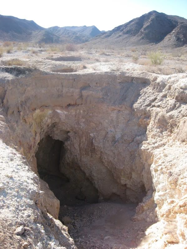
There is a fossil bed just south of the sulfur mine and just west of the old road. I will dig that post up later. More sites near Gonzaga Bay, too.
|
|
|
PaulW
Ultra Nomad
Posts: 3005
Registered: 5-21-2013
Member Is Offline
|
|
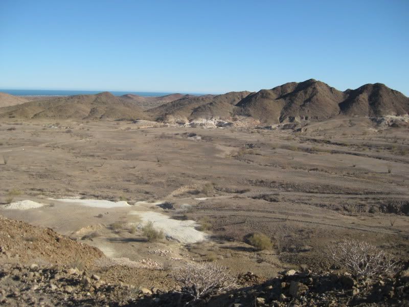
I just added a Google image. From where my track intersects OPR there is a difficult up hill place to get to the mine. The white coloration on the new
image is where all the quarrying took place. Quite a few digs. The most interesting place is where I wrote "Mine". A good place to collect specimens.
|
|
|
David K
Honored Nomad
Posts: 64480
Registered: 8-30-2002
Location: San Diego County
Member Is Offline
Mood: Have Baja Fever
|
|
Thank Paul.
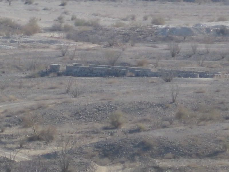
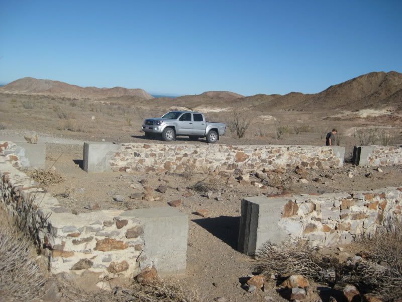
There are building footings near the white tailings area. A little hiking around the hill to the north will reveal lots of pics of the yellow
element... a rock that burns when lit!
There are photos of the buildings there in the 50s before they were demolished. The ore crusher was still in place when I first went there in the 60s.
It was over on the west side where the concrete walls are today.
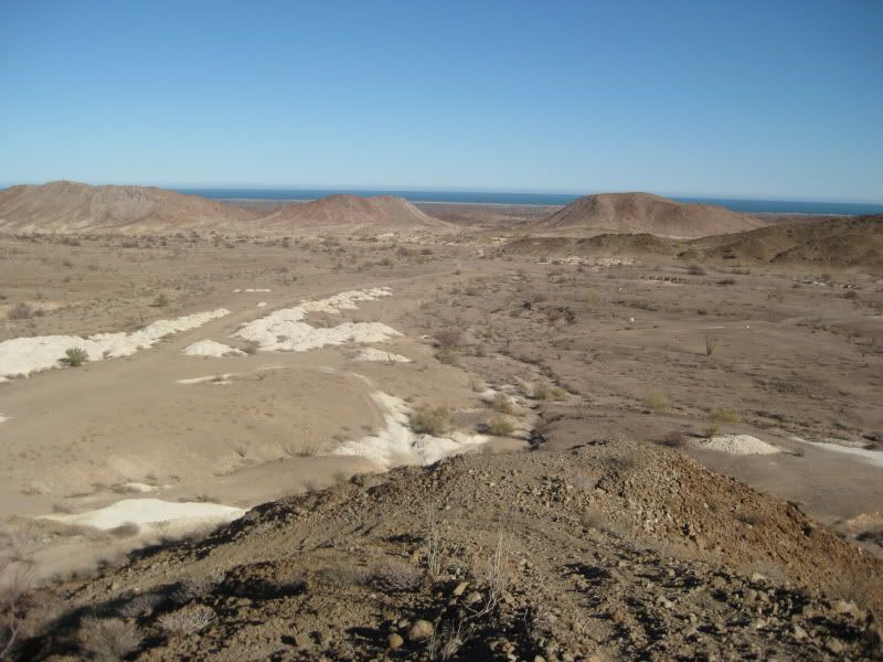
I found three photos at the sulfur mine taken in 1957 and 1961 by Howard Gulick (Lower California Guidebook author):
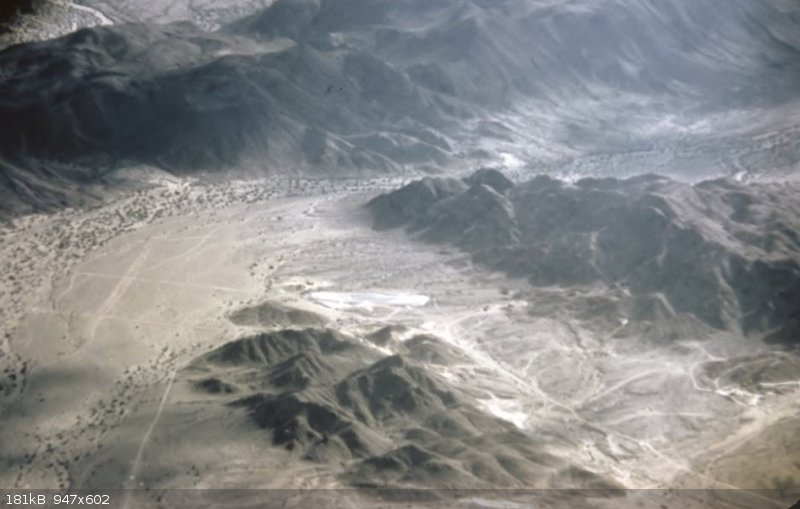
Aerial photo from 1957, looking west. The road to the coast (Km 32 now) is on the left running to the bottom. The airstrip is over to the left and is
crossed by the Puertecitos road. The valley with most of the sulfur is in the center and running to the lower right as is the old road to San Felipe.
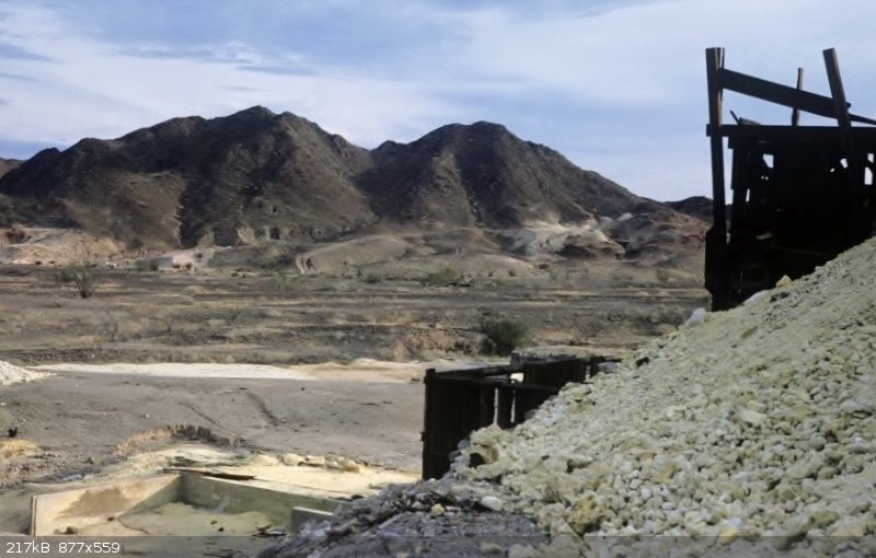
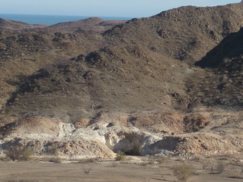
A 1961 photo by Howard Gulick at the ore crusher looking east across the mining valley.
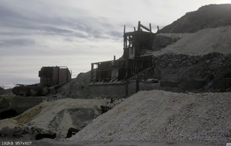
A close up of the ore crusher in 1961 by Howard Gulick.
In 2010, we scouted around the ore crusher area and took some panorama view photos from above the crusher site, south to north looking eastward:
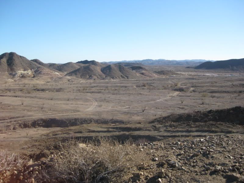

Some more...
[Edited on 12-4-2018 by David K]
|
|
|
David K
Honored Nomad
Posts: 64480
Registered: 8-30-2002
Location: San Diego County
Member Is Offline
Mood: Have Baja Fever
|
|
Wolfpack, here are the fossil beds (clams, oysters, sand dollars) photos I took in 2012... only a few miles south of the sulfur mine and just west of
the Old Puertecitos road: http://forums.bajanomad.com/viewthread.php?tid=57316
Sorry, I was following someone else to get there so I didn't take any direction notes or GPS. It wasn't over 5 miles from the sulfur mine, a lot less
maybe. We drove west from Hwy. 5 not far south of Colonia Delicias (Chelo's Cafe, and others).
|
|
|
PaulW
Ultra Nomad
Posts: 3005
Registered: 5-21-2013
Member Is Offline
|
|
Quote: Originally posted by David K  | Thank Paul.
There are building footings near the white tailings area. A little hiking around the hill to the north will reveal lots of pics of the yellow
element... a rock that burns when lit!
There are photos of the buildings there in the 50s before they were demolished. The ore crusher was still in place when I first went there in the 60s.
It was over on the west side where the concrete walls are today.
I found three photos at the sulfur mine taken in 1957 and 1961 by Howard Gulick (Lower California Guidebook author):
Aerial photo from 1957, looking west. The road to the coast (Km 32 now) is on the left running to the bottom. The airstrip is over to the left and is
crossed by the Puertecitos road. The valley with most of the sulfur is in the center and running to the lower right as is the old road to San Felipe.
David K] |
========
Thanks for the 1957 image.
I rotated it and compared it to a GE image.
Things of note:
* No evidence of a landing strip. In the 1957 image the AP was in a logical place in the flat of the sand wash. My track is south of the 1957 road
and the runway is probably at the intersection of my track and OPR
* Notice how the terrain has changed especially the ridge east of the large quarry.
* Of course there are more roads now and all in different places. That is except of OPR which is still as it was in 1957.
* Maybe a new runway parallel to my track ans slightly east of OPR. Faint but straight.
|
|
|
David K
Honored Nomad
Posts: 64480
Registered: 8-30-2002
Location: San Diego County
Member Is Offline
Mood: Have Baja Fever
|
|
Correct, no sign of the runway today... brush has grown on the strip and it hasn't been landed on since Arnold Senterfitt measured it in the 60s, I
bet!
Your track is on the runway, and was the road the older AAA map showed for La Roca. They incorrectly showed it as independent of the Nuevo Mazatlan
road but the two joined together a mile east of the Old Puertecitos road and then separated further east to head into the two different campos.
On their 1996 and later maps, the correctly showed the two roads:
[Edited on 12-4-2018 by David K]
|
|
|
4x4abc
Ultra Nomad
Posts: 4163
Registered: 4-24-2009
Location: La Paz, BCS
Member Is Offline
Mood: happy - always
|
|
| Quote: Originally posted by David K | I have driven it and the Azufre Pass route to Matomi and out in my Subarus, back when they had 13" tires. You just need to be smart where you place
the tires.
There is a fossil bed just south of the sulfur mine and just west of the old road. I will dig that post up later. More sites near Gonzaga Bay, too.
|
where is Azufre Pass?
Harald Pietschmann
|
|
|
David K
Honored Nomad
Posts: 64480
Registered: 8-30-2002
Location: San Diego County
Member Is Offline
Mood: Have Baja Fever
|
|
It is a name for Cañada el Parral used by Score. Bruce Barber called it Crazy Horse Canyon. It is an old road that connected the sulfur mine to Valle
Chico that I found in 1978 after a few searches. It appears on the detailed geology map of the early 1970s.
|
|
|
PaulW
Ultra Nomad
Posts: 3005
Registered: 5-21-2013
Member Is Offline
|
|
David is correct.
I think the name Azufre came about because there are so many drainage's called Parral and it was desirable to have a unique name that was simple for
map labeling and race notes simplification.
Locals still use Crazy Horse, but Azufre is gaining with the locals, especially newbies.
Azufre - First drive-able arroyo north of Matomi.
|
|
|
wolfpack
Newbie
Posts: 19
Registered: 9-17-2018
Location: Phoenix, AZ
Member Is Offline
|
|
Thanks David! The trip reports have been incredibly helpful! With any luck I’ll be able to post my own soon. We head south on Friday morning for
next month to explore San Felipe.
| Quote: Originally posted by David K | Wolfpack, here are the fossil beds (clams, oysters, sand dollars) photos I took in 2012... only a few miles south of the sulfur mine and just west of
the Old Puertecitos road: http://forums.bajanomad.com/viewthread.php?tid=57316
Sorry, I was following someone else to get there so I didn't take any direction notes or GPS. It wasn't over 5 miles from the sulfur mine, a lot less
maybe. We drove west from Hwy. 5 not far south of Colonia Delicias (Chelo's Cafe, and others). |
find what you love and let it kill you
|
|
|
| Pages:
1
2
3
4
5 |


