PaulW
Ultra Nomad

Posts: 3005
Registered: 5-21-2013
Member Is Offline
|
|
INEGI Map Download instructions
INEGI Key update with simple instructions.--again
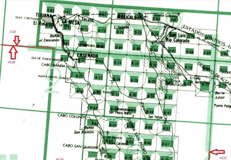
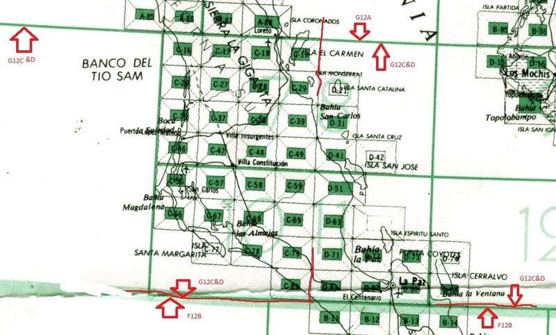
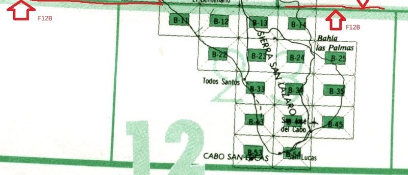
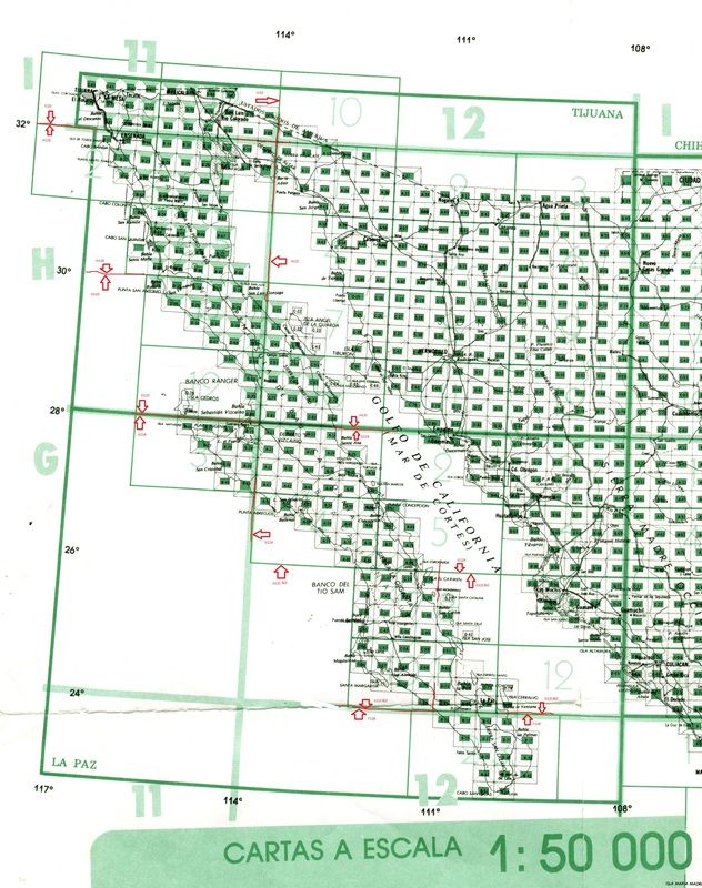
Here is my exercise to locate readable INEGI topo map key.
I have included all of Baja for the 50k maps.
Once you download the topo maps one can save them your stick or CD and take them to a copy place and have them printed. It is not cheap. Choose a
format that is near 26x32" like the original INEGI , but the copy place will not have that exact size.
Here is how to get your own topos. print them and sort out the ones you want. Key 1 is the start in the north
Go to
http://buscador.inegi.org.mx/search?q=%22Cartas+Topogr%C3%A1... :S:d1&entsp=a__inegi_politica_p72&lr=lang_es%7Clang_en&oe=UTF-8&ie=UTF-8&ip=10.187.2.255&entqr=3&filter=0&site=Produ
ctosBuscador&tlen=140 :S:d1&entsp=a__inegi_politica_p72&lr=lang_es%7Clang_en&oe=UTF-8&ie=UTF-8&ip=10.187.2.255&entqr=3&filter=0&site=Produ
ctosBuscador&tlen=140
In this link and enter the map number without quotes then click on “BUSAR”. The format for the map number is like this -- “G12A-54” or
“H11B-23”. Upper or lower case will work. Use care to get the grid correct. Do not download any format except PDF because you will not be able to
open the files and they are huge
I identified the boundaries of the various grids on the pictures below. It would be a good exercise to enhance the grids on your own copy so it will
be clear.
TIP, If you download and install google translate APP into Chrome then you can get English words for anything you get that is not English, This is
helpful when deciding which download to choose.
Click on the pdf symbol for the newest version such as 2003 ITRF92 and let the file go to the desktop. The ITRF92 datum is almost the same as datum
WGS84 which is the default for Google Earth. Older MX topos use NAD 1927 datum which is good to avoid.
Here are the grids to find the map numbers
Key 1
Key 3
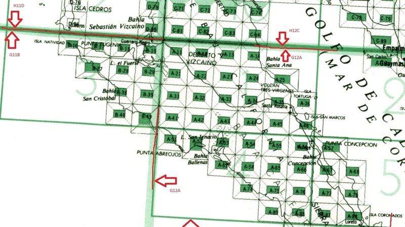
Key 4
Key 2
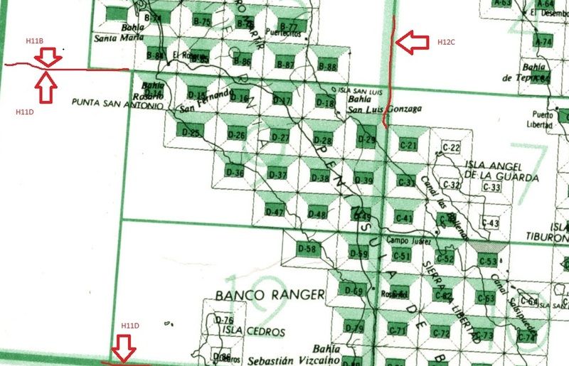
Key 5
Master key
|
|
|
mtgoat666
Select Nomad
Posts: 17302
Registered: 9-16-2006
Location: San Diego
Member Is Offline
Mood: Hot n spicy
|
|
A much easier way to locate and download maps is at:
http://www.beta.inegi.org.mx/temas/mapas/topografia/
|
|
|
David K
Honored Nomad
Posts: 64480
Registered: 8-30-2002
Location: San Diego County
Member Is Offline
Mood: Have Baja Fever
|
|
Wow, Mr. Goat, a most useful post, thank you!
|
|
|
MulegeAL
Nomad
Posts: 298
Registered: 8-25-2009
Location: PDX/Mulege
Member Is Offline
|
|
So far as I can tell, it's just Google Earth in Spanish format.
I'm not finding anything added or layered on top of that.
Data dates are at least a couple hurricanes old too.
E32 still best bet in the boonies, IMHO.
|
|
|
David K
Honored Nomad
Posts: 64480
Registered: 8-30-2002
Location: San Diego County
Member Is Offline
Mood: Have Baja Fever
|
|
Um, no... these are the government topographic maps. Nothing is from space or an American company. Click on the part of Mexico that you want to see as
a topo map, click the pdf option of map types, then zoom in.
|
|
|
PaulW
Ultra Nomad
Posts: 3005
Registered: 5-21-2013
Member Is Offline
|
|
On the pdf map legend you can read when the aerial photos were taken that were used to make the map. They are not very recent. The photos for the maps
were not taken from satellite, but were taken from an airplane. Just like the maps the USGS does for the US topo maps.
|
|
|
David K
Honored Nomad
Posts: 64480
Registered: 8-30-2002
Location: San Diego County
Member Is Offline
Mood: Have Baja Fever
|
|
I added the INEGI link to www.VivaBaja.com as it is quick and no entering map numbers:
http://www.beta.inegi.org.mx/temas/mapas/topografia/
Click on the 1:50,000 scale and then the map has all the squares on it. Just click... and select PDF (typically) to see the map.
|
|
|
4x4abc
Ultra Nomad
Posts: 4163
Registered: 4-24-2009
Location: La Paz, BCS
Member Is Offline
Mood: happy - always
|
|
is there anyone on this boar who can convert a couple of the INEGI files from SHP to PDF?
Like G12D52 is only offered by INEGI as a SHP file
my Mac does not read that and there are no free offers on the internet for Mac
Harald Pietschmann
|
|
|
TMW
Select Nomad
Posts: 10659
Registered: 9-1-2003
Location: Bakersfield, CA
Member Is Offline
|
|
Try this https://mygeodata.cloud/converter/shp-to-pdf
|
|
|
4x4abc
Ultra Nomad
Posts: 4163
Registered: 4-24-2009
Location: La Paz, BCS
Member Is Offline
Mood: happy - always
|
|
tried them some time before
does not work
the SHP on the INEGI site is a zip document
several SHP inside (the different layers of the image)
the online converter then produces several individual pdf files
what I need is a pdf that has all layers combined
imported into GIS program the shp file set will produce an image - that turn would have to be converted into pdf (or any other image file format like
tif or jpg)
anyone working with GIS a lot will know what I am talking about
Harald Pietschmann
|
|
|
4x4abc
Ultra Nomad
Posts: 4163
Registered: 4-24-2009
Location: La Paz, BCS
Member Is Offline
Mood: happy - always
|
|
the INEGI beta map function no longer works
http://www.beta.inegi.org.mx/temas/mapas/topografia/
Harald Pietschmann
|
|
|
David K
Honored Nomad
Posts: 64480
Registered: 8-30-2002
Location: San Diego County
Member Is Offline
Mood: Have Baja Fever
|
|
Did you break it, Harald??? 
|
|
|
4x4abc
Ultra Nomad
Posts: 4163
Registered: 4-24-2009
Location: La Paz, BCS
Member Is Offline
Mood: happy - always
|
|
dunno
Harald Pietschmann
|
|
|


