| Pages:
1
2 |
Gulliver
Senior Nomad

Posts: 651
Registered: 11-18-2013
Member Is Offline
|
|
Back roads from San Isidro to San Javier
Trip report. 3-30-2017
Mulege to Mulege via San Isidro, Comundu, San Javier and Loreto. 250 miles on a motorcycle.
Left Mulege at 7:30 a.m. and turned left off of Rt. 1 at km. 59 just past El Rosario. The first five miles or so are flat and relatively smooth but
the next ten or fifteen are badly chewed up. No repairs since last summer’s weather and in many places the water has left little but fist to head
sized rocks with some hog wallows. Tedious and slow. Still passable for anything with a bit of clearance. The western half to San Isidro is as usual.
Not a freeway but not alarming.
Plenty of gas in Purisma from a big tank right next to the road with even a pump and a meter (gasp!)
Back out east of San Isidro to the T intersection at the little tree and up the hill towards Comundu.
This road has been worked on a lot since last year and all of the washouts have been filled in with a bunch of grading. Even the hill down into Comudu
from the graveyard has been smoothed out.
To get gas in Comundu means driving 2 km.down the road from San Jose Comundu to near San Miguel Comundu and find the house with all of the plastic
jugs and a siphon hose. Ask around.
Now head up the hill out of San Jose Comundu. The road is steep as it climbs away from the river bed and the palms. For the first half of the drive it
is a decent road with very occasional goat ranchos. Then you reach the end of the valley and have to climb up around Mesa el Tunoso and over to the
descent to Palo Chino. The climb is steep and the switchbacks sharp and 4WD might be nice. No clearance problems I don’t think. I was on bike so I
can’t judge that very well.
Once on top I met a crew with a bulldozer and started a ten mile section where they have been working. The efforts are appreciated but the driver was
not an artiste with the blade. As the flagman said, “Mucho ondas!” Once it has been graded smooth it will be great but the combination of the
whoop de doos and the soft surface made for slow and fatiguing progress.
The descent to the area of Palo Chino is so much better. It used to be an off camber scrabble with loose rock over a solid rock base with vertical
steps and an actual hazard to negotiate. Now it will be nothing to warn about.
From there to the intersection with the paved San Javier road was routine.
What with gas and taco stops it was 4:00 p.m. and too hot to camp so I hit the pavement for Mulege, a hot shower and a nice bed. Today is loafing
about and gobbling Ibuprofen.
By next Summer it may have all changed but that’s Baja.
|
|
|
David K
Honored Nomad
Posts: 64507
Registered: 8-30-2002
Location: San Diego County
Member Is Offline
Mood: Have Baja Fever
|
|
Thanks for posting this... it wasn't here before!
Appreciate the details!
Here's an area map so readers unfamiliar can visualize:
San Isidro
La Purisima
San Miguel Comondu
San Jose Comondu
El Horno
Palo Chino
San Javier
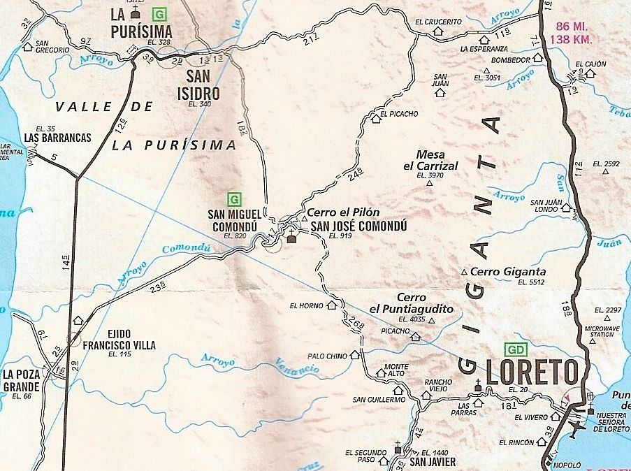
Since this map was made, the road to San Javier from Loreto is now paved and the road from San Miguel Comondu to Ejido Francisco Villa is all paved.
|
|
|
KurtG
Super Nomad
Posts: 1201
Registered: 1-27-2004
Location: California Central Coast
Member Is Offline
Mood: Press On Regardless!!
|
|
Following is a cut and paste from my post on the dirt bike thread. The road crew didn't happen to have a front end loader with the windows missing?
"I drove from San Javier/Comondu/San Isidro/Hwy 1 on 3/21. Glad it was you riding it and not me! Going north from the SJ road about 10 miles in there
is the sweeping ascent onto the mesa. Work was being done and a dozer was spreading fresh dirt so it was very loose surface. Used low range and
climbed the hill, about half way up was a 2wd Toyota pickup carrying a large compressor. He could go no further but could back up a bit to let me go
by. Right after that I met the dozer coming down and there was just room for us to pass. At about 2/3's up the grade I saw a bright spot of
Caterpillar yellow and as I got closer realized it was a large front end loader tipped over on it's side. Again just enough room for me to get by
without running off the cliff but it was kinda close. Went past, stopped and walked back down to talk to the two guys there. The younger, in his 20's,
said he was the driver. He was working aimed uphill when his brakes failed. This was a very bad situation since the grade is steep and going over the
side at that point no doubt would have been fatal. He said he jammed it into the lowest gear, killed the engine and steered into the cliff side. The
rig went over on it's side and slid to a stop. His only injury was some skin scraped off his hip. He still had a pretty good adrenaline rush going on
which was understandable.
I continued on to Comondu, some rough spots with loose rock but not too bad. After La Purisima and San Isidro I headed east toward Hwy 1 keeping in
mind David's recent report on that road. I have traveled that route quite a number of times over the years but this was the worst. There was nowhere
that I didn't think I could traverse but it was very rough and very slow going, often crawling along in low range especially on the steep portions.
Took me about 2 1/2 hours to go 30 miles. I feel bad for the ranchers out there, it must be very difficult for them.
I was driving our old 2000 Explorer and managed to not break anything."
|
|
|
BigBearRider
Super Nomad
Posts: 1299
Registered: 4-30-2015
Location: Big Bear, Punta Chivato, and Cabo
Member Is Offline
Mood: 
|
|
Wow, Mike!
|
|
|
Gulliver
Senior Nomad
Posts: 651
Registered: 11-18-2013
Member Is Offline
|
|
The loader was parked off to one side up on top. I didn't notice the windows. There were a lot of loose rocks trying their best to embarrass me just
then.
|
|
|
wilderone
Ultra Nomad
Posts: 3779
Registered: 2-9-2004
Member Is Offline
|
|
"a crew with a bulldozer and started a ten mile section where they have been working"
Takin' all the fun out of it.
|
|
|
KurtG
Super Nomad
Posts: 1201
Registered: 1-27-2004
Location: California Central Coast
Member Is Offline
Mood: Press On Regardless!!
|
|
Quote: Originally posted by Gulliver  | | The loader was parked off to one side up on top. I didn't notice the windows. There were a lot of loose rocks trying their best to embarrass me just
then. |
I admire your riding ability, that is a tough road!
|
|
|
Gulliver
Senior Nomad
Posts: 651
Registered: 11-18-2013
Member Is Offline
|
|
Except for a little bruise on my right foot where one of those evil rocks made a try for me, I'm pretty much healed up and ready for more retarded
behavior.
Next year might be a work party to see if the road from Mission Guadalupe to the West can be repaired enough for bikes. The last group of three a year
ago had to spend so much time moving around rocks to get through that A: they ran out of water and B: they swore that they would never try it again. A
group of five made it through the year before but they, too, swore never to return. It is now referred to by us two wheeled whiners as Crybaby Canyon.
The Mission Guadalupe to San Jose de Magdalena leg is probably gone forever. It's now fairly dangerous to even approach the washed out area from the
up hill side due to a very off camber and loose surface. And there are no fill materials left nearby for repairs. Too bad. It was a great loop.
[Edited on 4-1-2017 by Gulliver]
[Edited on 4-1-2017 by Gulliver]
|
|
|
KurtG
Super Nomad
Posts: 1201
Registered: 1-27-2004
Location: California Central Coast
Member Is Offline
Mood: Press On Regardless!!
|
|
| Quote: Originally posted by Gulliver | Except for a little bruise on my right foot where one of those evil rocks made a try for me, I'm pretty much healed up and ready for more retarded
behavior.
Next year might be a work party to see if the road from Mission Guadalupe to the West can be repaired enough for bikes. The last group of three a year
ago had to spend so much time moving around rocks to get through that A: they ran out of water and B: they swore that they would never try it again. A
group of five made it through the year before but they, too, swore never to return. It is now referred to by us two wheeled whiners as Crybaby Canyon.
The Mission Guadalupe to San Jose de Magdalena leg is probably gone forever. It's now fairly dangerous to even approach the washed out area from the
up hill side due to a very off camber and loose surface. And there are no fill materials left nearby for repairs. Too bad. It was a great loop.
[Edited on 4-1-2017 by Gulliver]
[Edited on 4-1-2017 by Gulliver] |
I was fortunate to be able to drive the Guadalupe/San Pedro/San Juan de la Pila/San Ignacio Lagoon route twice back when it was in good shape. The
first time I was a day or two behind the bulldozer. Spectacular country. And like you, I miss the Guadalupe/San Jose de Magdalena loop. It was a
favorite day ride out of Mulege for years. I was very fortunate that 15-20 years ago there was a short time that most all those back roads were
pretty good and I'm glad I took advantage.
|
|
|
MulegeAL
Nomad
Posts: 298
Registered: 8-25-2009
Location: PDX/Mulege
Member Is Offline
|
|
Thanks for the update Mike!
What blew my mind when we were on Javier to Comondu road was coming across guys riding bicycles north to south in the steep section that was being
graded.
I dropped into the top of the canyon towards San Jose last season, it is very bad shape, almost didn't get out. There is a mule track on the NW side
of the canyon, starts out at the saddle/flat area with the shrine. I think that is still being used, it stays high above the box canyon section, then
drops down. But I have never tried it, bike or boots.
Fixing the road enough to go westbound is an interesting idea. I would bet it has to veer north a bit and drop into the box canyon above El Datil,
just north of the origional route, which is totally hammered by flood damage for several miles.
[Edited on 4-1-2017 by MulegeAL]
|
|
|
David K
Honored Nomad
Posts: 64507
Registered: 8-30-2002
Location: San Diego County
Member Is Offline
Mood: Have Baja Fever
|
|
Sounds like EL CAMINO REAL! 
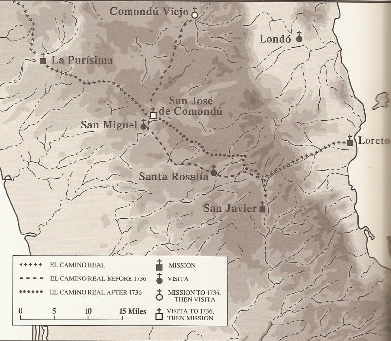
Harry Crosby was not able to obtain mules in Loreto or San Javier for his research. He began riding on El Camino Real in San José Comondú. So the
map between Loreto and Comondú lacks that detail. The double line road is where Jesuit road building is obvious, the single line is the route it was
using but not ridden in for the 1974 book or not seen.
|
|
|
Sweetwater
Senior Nomad
Posts: 915
Registered: 11-26-2010
Member Is Offline
Mood: chilly today hot tomale
|
|
We made the run from Loreto to San Javier over Los Hornos to the Comondu valley on March 2nd. I was very surprised that the road was in better
condition than expected. The road crew was just getting started so we didn't have much recently bladed material but aside from the rockiness it was
good. The drive to the west was marred by the big vado taking us down, sudden and unexpected injury to one rider/bike.
Glad to hear the gasolina situation has been resolved, the Federales must have left the region. There was no barrel gas available the 2nd or 3rd of
March.
I rode solo back to the east the next day out of San Juanico via La Parisima. The road out of the valley was badly rutted and very rocky. The vados
had ledges and very rocky approaches, heard that someone on the Mulege trip took a bad spill but I made it without an incident. I've been on that road
5 times over the years and this is the worst I've seen it, no road work in progress when I crossed.
Can anyone tell me about the road west out of San Javier? I've heard the water crossings are high this year.
Everbody\'s preachin\' at me that we all wanna git to heaven, trouble is, nobody wants to die to git there.-BB King
Reality is what does not go away when you stop believing in it. -Philip K Dick
Nothing is worse than active ignorance. Johann Wolfgang von Goethe(1749-1832, German writer, artist and politician)
When choosing between two evils, I always like to try the one I\'ve never tried before. - Mae West
Experience is what keeps a man who makes the same mistake twice from admitting it the third time around.
|
|
|
Gulliver
Senior Nomad
Posts: 651
Registered: 11-18-2013
Member Is Offline
|
|
Sweetwater: I have talked to a couple of adventure bike groups who came through to San Javier from Insurgentes this year and heard no particular scare
stories about drowning. But I haven't been down that road for a long time.
Al: Yes about the way in towards San Jose de Magdalina from the West. It was your experience and reports that I was going on when I commented about
that mess. I didn't get nearly as far down and was alarmed by the road. And you you don't like it, I hate it. Post that pix of your buddy standing on
what's left of the concrete abutment. That tells it all.
It will be next Fall before I get back up to the saddle and can look at that mule track. I'm not a big fan of walking but it would be interesting if
there was a basis for a bypass of the disaster area.
Has anyone been through that other loop to San Jose de Magdalena this year? The one that leaves Rt. 1 at Palo Verde and comes back out to Magdalena? I
might do a quick day trip out there to look it over.
[Edited on 4-1-2017 by Gulliver]
|
|
|
Gulliver
Senior Nomad
Posts: 651
Registered: 11-18-2013
Member Is Offline
|
|
Here's a link to the SPOT track of the trip. I haven't learned to extract that much information but it does seem to show the places where I was able
to get going and where I was working. The track points are ten minutes apart. It's a new toy to me.
http://share.findmespot.com/shared/faces/viewspots.jsp?glId=...
|
|
|
AKgringo
Elite Nomad
Posts: 5820
Registered: 9-20-2014
Location: Anchorage, AK (no mas!)
Member Is Offline
Mood: Retireded
|
|
This is not very recent, but I drove from Insurgentes to San Javier the third week of December. I was surprised by how many times I crossed the
arroyo, but none of them were challenging for any decent two wheel drive vehicle. I had driven the San Raymundo arroyo a couple of weeks earlier, and
it was much rougher and deeper!
I was driving a soft top Kia Sportage, and never bothered to put the hubs in. I would not want to drive a motorhome or pull a boat through there.
If you are not living on the edge, you are taking up too much space!
"Could do better if he tried!" Report card comments from most of my grade school teachers. Sadly, still true!
|
|
|
Gulliver
Senior Nomad
Posts: 651
Registered: 11-18-2013
Member Is Offline
|
|
Yeah, the San Raymundo is one of those routes that I don't think about much as it seems like it's about a thousand miles long when I'm grinding down
that never ending river bed.
I've never cared that much for the West side of the peninsula that much anyway. Too flat and not that much scenery.
|
|
|
Sweetwater
Senior Nomad
Posts: 915
Registered: 11-26-2010
Member Is Offline
Mood: chilly today hot tomale
|
|
Great link, it won't last on Spot but I think you can rescue the route and data with a SpotWalla account, just set the dates to get it stored.
Thanks for the responses on the San Javier to Zaragoza route, I think I met a very conservative rider who hadn't actually ridden it. I did read a
BigDog report of the northern route out of San Juanico to Mulege and they did cross the river a lot, drowned a bike in their group but made a
successful ride. That's one ride I haven't made and I might put it on the bucket list.
Cheers
Everbody\'s preachin\' at me that we all wanna git to heaven, trouble is, nobody wants to die to git there.-BB King
Reality is what does not go away when you stop believing in it. -Philip K Dick
Nothing is worse than active ignorance. Johann Wolfgang von Goethe(1749-1832, German writer, artist and politician)
When choosing between two evils, I always like to try the one I\'ve never tried before. - Mae West
Experience is what keeps a man who makes the same mistake twice from admitting it the third time around.
|
|
|
Gulliver
Senior Nomad
Posts: 651
Registered: 11-18-2013
Member Is Offline
|
|
I wondered why the SPOT data evaporated after a while. Another scheme to get into my wallet.
I bought the SPOT for safety reasons so having the track go away isn't a big deal for me. Barbara says she doesn't want any tedious delays in getting
the life insurance money.
|
|
|
chuckie
Elite Nomad
Posts: 6082
Registered: 2-20-2012
Location: Kansas Prairies
Member Is Offline
Mood: Weary
|
|
I like Barbara already....and havn't met her!
|
|
|
honda tom
Nomad
Posts: 493
Registered: 8-28-2003
Location: middle calif
Member Is Offline
|
|
just got back and did the route from san isidro to comondu to san Javier.
dozer still there working the area between horno and chino. road was in good condition.
a lot of pipe and refilling being done in the washouts as you get closer to the san Javier junction.
|
|
|
| Pages:
1
2 |


