| Pages:
1
2
3
4 |
ehall
Super Nomad

Posts: 1906
Registered: 3-29-2014
Location: Buckeye, Az
Member Is Offline
Mood: It's 5 o'clock somewhere
|
|
Didn't know that Bruce. I don't know kevin. I do know a lot of the trails are open and the sleeping bag trail is one of the best single tracks I have
ever ridden.
|
|
|
TMW
Select Nomad
Posts: 10659
Registered: 9-1-2003
Location: Bakersfield, CA
Member Is Offline
|
|
Many if not most of the roads down Baja are used in various races and many of them have a GPS track that you can get from Murdock Nav.
http://www.murdocknav.com/mapsmex1.php
|
|
|
TMW
Select Nomad
Posts: 10659
Registered: 9-1-2003
Location: Bakersfield, CA
Member Is Offline
|
|
Quote: Originally posted by ehall  | | Didn't know that Bruce. I don't know kevin. I do know a lot of the trails are open and the sleeping bag trail is one of the best single tracks I have
ever ridden. |
What/where is the sleeping bag trail?
|
|
|
bajatrailrider
Super Nomad
Posts: 2423
Registered: 1-24-2015
Location: Mexico
Member Is Offline
Mood: Happy
|
|
Ed showed me sleeping bag trail From Vicente Guerrero to San Quintin. Its Moto only med hard going South.Going north hand full.
|
|
|
TMW
Select Nomad
Posts: 10659
Registered: 9-1-2003
Location: Bakersfield, CA
Member Is Offline
|
|
If you are really adventurist do the No Wimp Trail, El Barril to San Ignacio. Picking your way thru the La Trinidad arroyo to El Gato is very
interesting. Bring gas and water.
|
|
|
TMW
Select Nomad
Posts: 10659
Registered: 9-1-2003
Location: Bakersfield, CA
Member Is Offline
|
|
So it doesn't follow any of the Baja 1000 tracks.
|
|
|
David K
Honored Nomad
Posts: 64490
Registered: 8-30-2002
Location: San Diego County
Member Is Offline
Mood: Have Baja Fever
|
|
Day 1 was from El Rosario to just beyond Canoas. Including stops at Santa Catarina Landing and not early start that day.
Day 2 went from that camp to Punta Lobos beach camp. Slow day, rough south of San Jose.
Day 3 was from Lobos to Hwy. 1 south of Pta. Rosarito that included a visit to Santa Rosalillita and the harbor. That same day we went on to Shari's
at Asuncion.
That is why I said it was a 2 day drive just for the remote coast section and not 3. Obviously, fast riding on m/c could do it in 1 day.
|
|
|
ehall
Super Nomad
Posts: 1906
Registered: 3-29-2014
Location: Buckeye, Az
Member Is Offline
Mood: It's 5 o'clock somewhere
|
|
No Tom. It is just a single track gpskevin included in his ride for the dirt bikes on the trip. I have heard it was made by Jimmy sones and friends
quite a while ago.
|
|
|
TMW
Select Nomad
Posts: 10659
Registered: 9-1-2003
Location: Bakersfield, CA
Member Is Offline
|
|
If you are doing the 7 sisters route stop over night at Bahia Blanco. Before dark and at sunrise is a great time for surf fishing.
|
|
|
joerover
Banned
Posts: 676
Registered: 2-3-2011
Location: earth
Member Is Offline
Mood: sleepy
|
|
The map google in the middle of the page shows a route from Bahia De Los Angles south to MX 1. It does not go through El Arco, it joins the highway
east of San Ignacio. Has anyone been this way? My Nationañ Geographic map does not show roads there.
the fat lady is breeding
which means
The fat ladys are breeding
|
|
|
TMW
Select Nomad
Posts: 10659
Registered: 9-1-2003
Location: Bakersfield, CA
Member Is Offline
|
|
That is what's called the No Wimp Trail from El Barril to San Ignacio. Just did it a week ago.
|
|
|
TMW
Select Nomad
Posts: 10659
Registered: 9-1-2003
Location: Bakersfield, CA
Member Is Offline
|
|
Since the ops kids are 13 and 15 I assume his time frame is Thanksgiving with the kids out of school. Thanksgiving is the week after the Baja 1000
race. This year the Baja 1000 will celebrate it's 50th anniversary with a run to La Paz. All he has to do is follow the SCORE markers and all will be
good. Course will be posted at the Off Road Expo in Pomona in Oct.
|
|
|
geoffff
Senior Nomad
Posts: 643
Registered: 1-15-2009
Member Is Offline
|
|
The Google map gpsKevin has on his web page can be "shared" with your own maps in your own Google account, and then the tracks and waypoints can be
downloaded to your computer. Here they are in both Google Earth and GPX formats:
Baja-California-Discovery-Route--gpsKevin.kmz
Baja-California-Discovery-Route--gpsKevin.gpx
-- Geoff
|
|
|
JZ
Elite Nomad
Posts: 9262
Registered: 10-3-2003
Member Is Offline
|
|
| Quote: Originally posted by TMW | | If you are doing the 7 sisters route stop over night at Bahia Blanco. Before dark and at sunrise is a great time for surf fishing.
|
On our May trip I don't know if we can go much South of Blanco. From what I've seen it looks like a really pretty bay? Is it nice?
From there what would be the easiest way back out to Hwy1?
|
|
|
TMW
Select Nomad
Posts: 10659
Registered: 9-1-2003
Location: Bakersfield, CA
Member Is Offline
|
|
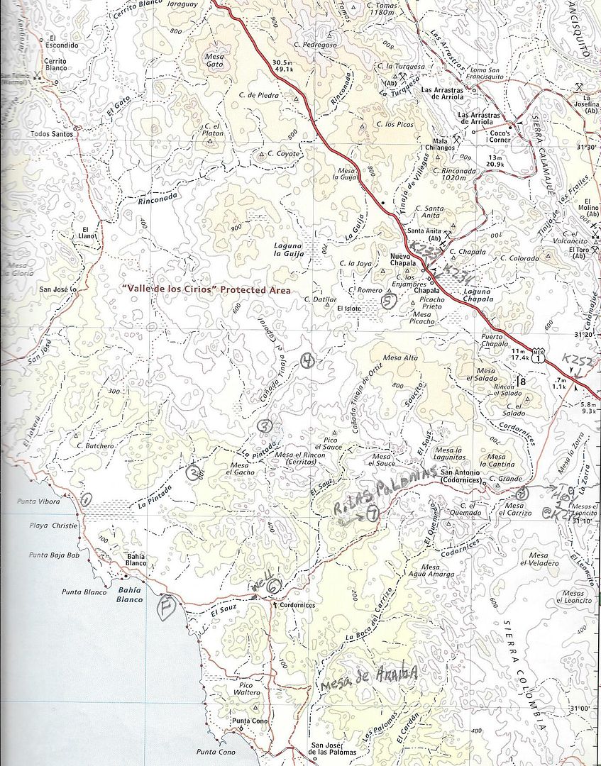
It is a really beautiful beach area. At the very north end is a small fish camp. I don't know how active it is. About midway is a sort of rock section
and that is where I usually stay. From there you you can follow the road to a Y, go left and follow it to an abandoned ranch with an old windmill.
Follow the road east. If memory serves me you take the left road at the three Ys you will come to. If you go too far there is a working ranch called
Las Palomas. You want to go to the south or the right side as you get to it.
This sounds a little complicated but it's because there are several roads in the area and they probably all come together I don't know. Anyway once
you start up the mountain out of the arroyo it is or was a good road to Hwy 1 at KM252. There is a jct and the right fork goes to Hwy 1 at KM 270.
SCORE has used this leg for the Baja 1000 course. At the Jct you will see a white house to your left setting up the side of the mountain. There are a
couple of abandoned ranches along the way.
In the section from the windmill to Rancho Las Palomas there are lots of silt beds, pick your line carefully.
If you want I can trace the route on Google Earth with way points or I can convert it to a GPX file for your GPS.
In the map below F is the fishing spot. The first Y is just after you turn inland not shown on map.
|
|
|
JZ
Elite Nomad
Posts: 9262
Registered: 10-3-2003
Member Is Offline
|
|
| Quote: Originally posted by TMW |
If you want I can trace the route on Google Earth with way points or I can convert it to a GPX file for your GPS.
In the map below F is the fishing spot. The first Y is just after you turn inland not shown on map.
[/URL] |
Thanks man. Google Earth would be awesome. I can convert for GPS.
About how long did it take you? Easy enough for a 4x4?
I'd really like to make it down to Lobos, it might be a little too far for this trip. Looks like there are dunes down there.
|
|
|
joerover
Banned
Posts: 676
Registered: 2-3-2011
Location: earth
Member Is Offline
Mood: sleepy
|
|
| Quote: Originally posted by TMW | | That is what's called the No Wimp Trail from El Barril to San Ignacio. Just did it a week ago. |
Got any videos from the no wimps trail? Any water out there?
Anything at all on the trail?
the fat lady is breeding
which means
The fat ladys are breeding
|
|
|
TMW
Select Nomad
Posts: 10659
Registered: 9-1-2003
Location: Bakersfield, CA
Member Is Offline
|
|
I don't know of any videos. I did the trail in Dec. and a couple of weeks ago. Here is the report from Dec.
http://forums.bajanomad.com/viewthread.php?tid=85247
There are a couple of abandoned ranches along the way that may have water I don't know for sure. We always take plenty of water with us as well as
gas. It's pretty much an abandoned area of Baja. The scenery is beautiful.
I'm told that the northern end around Rancho San Miguel and Rancho Santa Barbara is being fenced off with gates, Maybe locked, but who knows for sure.
We were hoping to meet the man in charge at Rancho La ILusion on our last trip but no one was there.
|
|
|
joerover
Banned
Posts: 676
Registered: 2-3-2011
Location: earth
Member Is Offline
Mood: sleepy
|
|
oh, so it is a bicycle route.
The Baja Divide Bicycle Route, goes from Biaha De Los Angles to San Ignacio through El Arco,¡.
Any idea if the no whips trail would be better or worse?
the fat lady is breeding
which means
The fat ladys are breeding
|
|
|
David K
Honored Nomad
Posts: 64490
Registered: 8-30-2002
Location: San Diego County
Member Is Offline
Mood: Have Baja Fever
|
|
No, not really! It is a rocky, sandy, rough track along or near the coast from El Barril to Punta Trinidad then goes west in the arroyo and on to
mission roads, including El Camino Real south by Santa Marta to Hwy. 1, east of San Ignacio.
This was a motorcycle route until some hardy Nomads got their 4x4s through, too.
|
|
|
| Pages:
1
2
3
4 |


