| Pages:
1
2 |
Fatboy
Senior Nomad

Posts: 711
Registered: 6-28-2005
Member Is Offline
|
|
Followup to Search for Henderson's Rock-Pile
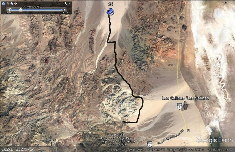
For the few of you that are interested here are the Google earth tracks of my recent search for Walter Henderson's Rock pile.
I hiked a little over 32 miles in the week I was there and came across two windbreaks for sleeping, a well made fire pit, a rams head, a small trash
pile from the 1960's or 1970's, an old door panel off a 1930's or 1940's car, an old can and 5 or 6 Mylar balloons mostly wishing people Happy
Birthday or to get well soon.
I also saw some wildlife including a fox and a couple of bighorn sheep.
For some pictures and a short trip report go here: http://forums.bajanomad.com/viewthread.php?tid=86277#pid1075...
On the first day I drove down from 29 Palms, crossed at Calexico, exchanged some money, had my vehicle briefly searched at the military checkpoint at
the junction of Highways 3 and 5. From there I headed east towards Ensenada before turning off a few miles west of El Arrajal into a large wash.
Hikes are shown in RED except the estimated hike 5 and a future suggested hike which is in YELLOW, and the drives from camp to camp are shown in BLACK
while the drive in to camp one is in BLUE
DRIVE IN TO CAMP 1
 
|
|
|
Fatboy
Senior Nomad
Posts: 711
Registered: 6-28-2005
Member Is Offline
|
|
That evening after setting up camp I hiked the surrounding hills. It was a 2.4 mile hike along the ridge.
Not far from camp I found a rock pile that looked like it was made as a windbreak to sleep behind. There was also several other areas there that
looked as if they had been cleared of rocks.


|
|
|
Fatboy
Senior Nomad
Posts: 711
Registered: 6-28-2005
Member Is Offline
|
|
The next morning, loaded down with a lot of water and minimal camping supplies I headed out. This hike was 7.5 miles long and in one of the washes
heading down the other side of the ridge I came across a well made fire pit.
A little ways downstream from the fire pit was a small cave/overhang that looked as if someone had piled rocks up at the entrance.
Then in a different wash I came across another sleeping windbreak rock pile.
I set up camp in the desert and went to sleep hoping that no coyotes would attack me.
  
|
|
|
Fatboy
Senior Nomad
Posts: 711
Registered: 6-28-2005
Member Is Offline
|
|
The next morning I hiked back to my jeep, this hike was 3.7 miles long and involved some scrambling and sliding a loose, rocky, and steep draw to get
off the ridge line.
 
|
|
|
Fatboy
Senior Nomad
Posts: 711
Registered: 6-28-2005
Member Is Offline
|
|
Once back in camp I planned on spending the night there before driving to my next campsite but the wind was blowing so hard I packed up that afternoon
and drove to camp two.
  
|
|
|
Fatboy
Senior Nomad
Posts: 711
Registered: 6-28-2005
Member Is Offline
|
|
The road was in pretty bad shape due to the races and was slow going. I made it two my second camp in time to setup before the sun set.
The next morning my goal was to hike up to where I could see where I hike the day before to have as much coverage as possible.
The first hike that day was 2.2 miles and was my fourth hike of the trip. I found several pieces of tourmaline and some of it was rutilated in quartz.
  
|
|
|
Fatboy
Senior Nomad
Posts: 711
Registered: 6-28-2005
Member Is Offline
|
|
After hike 4 I relaxed in camp until the worst of the days heat passed and headed out on another short hike.
My GPS track of this hike is corrupted so this is an estimate of where I hiked that day.
The YELLOW track is my estimated hike, the RED line was the earlier hike and the BLACK line was the drive in.
 
|
|
|
Fatboy
Senior Nomad
Posts: 711
Registered: 6-28-2005
Member Is Offline
|
|
I returned to camp after dark glad that I had a flashlight with me.
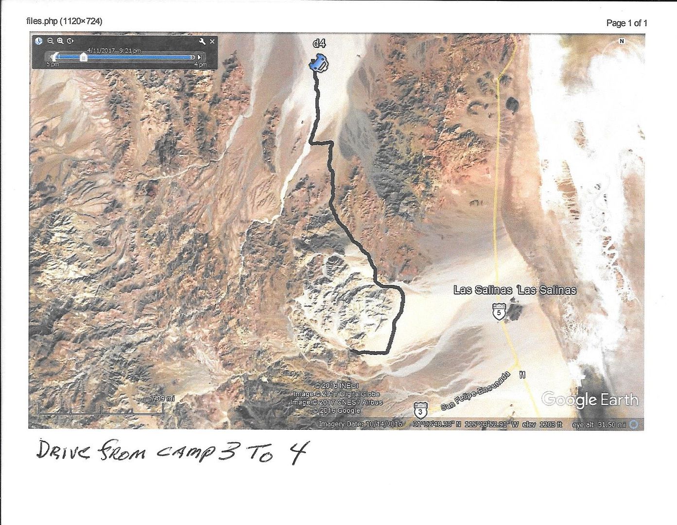
The following morning I drove to camp 3.
I first went up Arroyo Arrajal before turning around and going up an unnamed wash that had no tire marks to follow.
It took me several tries before I found a way through. On the way out I found it was much more open and easier to drive on the northern edge.

|
|
|
Fatboy
Senior Nomad
Posts: 711
Registered: 6-28-2005
Member Is Offline
|
|
The next morning I hiked up the wash and into a large valley. On this hike I came across the old door panel, a small pile of trash and tire marks.
This hike was 4.3 miles long.
The pile of trash consisted of some bottles including a milk of magnesium, Hires root beer and several aspirin or medicine bottles along with some
bicycle parts, plates and cups, and old cans. The bottles appear to be 1960's to perhaps early 1970's era.
From there I saw some old tire tracks with bushes growing in the tracks indicating a fair amount of time has passed since this was used last.
  
|
|
|
Fatboy
Senior Nomad
Posts: 711
Registered: 6-28-2005
Member Is Offline
|
|
My final hike was 10.8 miles long and seemed most encouraging for a way to reach Arroyo Grande.
Along this hike I was watched by a fox, saw several bighorn sheep, came across a nice ram's head, and found an old tin can.
  
|
|
|
Fatboy
Senior Nomad
Posts: 711
Registered: 6-28-2005
Member Is Offline
|
|
Once back to camp I packed up and headed out.
On the drive out I passed a telephone/graph pole that was perhaps part of the Pole Line rd and also found a working fire extinguisher.
I had to camp out one more night before finally hitting the pavement and heading back to my sisters in 29 Palms.
|
|
|
TMW
Select Nomad
Posts: 10659
Registered: 9-1-2003
Location: Bakersfield, CA
Member Is Offline
|
|
Quote: Originally posted by Fatboy  | I returned to camp after dark glad that I had a flashlight with me.
The following morning I drove to camp 3.
I first went up Arroyo Arrajal before turning around and going up an unnamed wash that had no tire marks to follow.
It took me several tries before I found a way through. On the way out I found it was much more open and easier to drive on the northern edge.
|
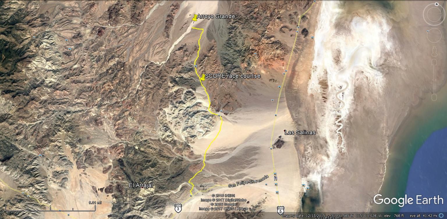
This route is the usual SCORE race course the top end is Arroyo Grande, the wells are to the north.
|
|
|
TMW
Select Nomad
Posts: 10659
Registered: 9-1-2003
Location: Bakersfield, CA
Member Is Offline
|
|
Wow a lot of hiking. You did a lot of exploring and at least eliminated several areas that DK can build on. Good job, thanks.
|
|
|
Fatboy
Senior Nomad
Posts: 711
Registered: 6-28-2005
Member Is Offline
|
|
| Quote: Originally posted by TMW | | Quote: Originally posted by Fatboy | I returned to camp after dark glad that I had a flashlight with me.
The following morning I drove to camp 3.
I first went up Arroyo Arrajal before turning around and going up an unnamed wash that had no tire marks to follow.
It took me several tries before I found a way through. On the way out I found it was much more open and easier to drive on the northern edge.
|
This route is the usual SCORE race course the top end is Arroyo Grande, the wells are to the north. |
Which route? The wash I went up showed little to no sign of use. It was almost like a lost valley.
Or are you referring to the route I took in to my first camp and the route out to pavement that I followed?
Sometimes this is all so confusing via the web. 
|
|
|
PaulW
Ultra Nomad
Posts: 3005
Registered: 5-21-2013
Member Is Offline
|
|
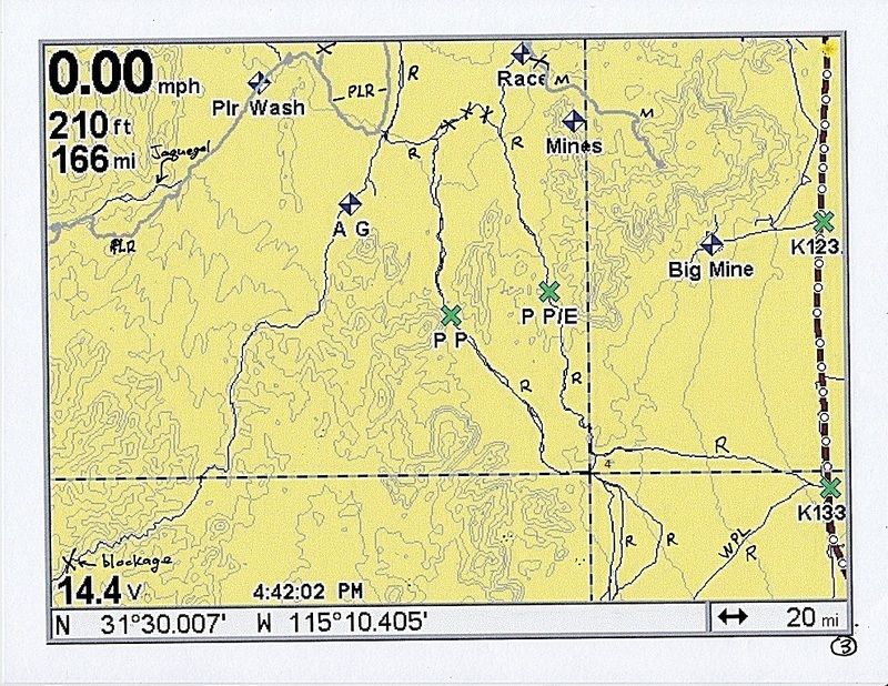
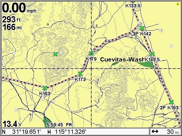
The pics below show roads near where Fatboy did his hikes
I have captured all Fatboy’s pics and his details for use for my search next winter.
Legend for PaulW’s pics:
X =do not drive
R =race road
M = mine road, note the X
A G =Arroyo Grande
Plr =Pole line road
PP =Pinta Pass
PP/E=Pinta Pass East
4 =Four corners @31 30.007 -115 10.405
W PL= Wood Power line race road
A = Arroyo Arrajal
Green X in the mountain area next to Cerro Arrajal is the slate mine
Cerro Arrajal is the white circle.
2P = Two Poles @ Km 163
3P is three poles @ Km142
KM 133.8 or nearby is known as Chinero
Dots on the highway are KM markers
|
|
|
Fatboy
Senior Nomad
Posts: 711
Registered: 6-28-2005
Member Is Offline
|
|
PaulW.... if you or DavidK want any actual tracks let me know.
I went on this trip thinking that Henderson was much closer to El Arrajal/Sharps peak.
I also believed that he did not cover as much ground as DavidK and others believe. In other words, he never made it anywhere near Arroyo Grande.
Now I believe that he was not close to El Arrajal, the area of my first 5 hikes. The area is very rugged and at times downright dangerous.
My last hike made me realize somethings and open up the possibilities of him reaching Arroyo Grande.
I now believe you could reach Arroyo Grande in a day and that you would be in hills only later in the day. You would hike the wash in the morning and
you can cover ground pretty fast and knock out the most miles in the fewest hours.
That would set you up to be in the dividing hills before noon.
The only problem is that he says he camped further south and it is not on the line from Sharps peak to the unnamed peak about 12 miles away.
|
|
|
TMW
Select Nomad
Posts: 10659
Registered: 9-1-2003
Location: Bakersfield, CA
Member Is Offline
|
|
| Quote: Originally posted by Fatboy |
[/rquote]
This route is the usual SCORE race course the top end is Arroyo Grande, the wells are to the north.[/rquote]
Which route? The wash I went up showed little to no sign of use. It was almost like a lost valley.
Or are you referring to the route I took in to my first camp and the route out to pavement that I followed?
Sometimes this is all so confusing via the web. |
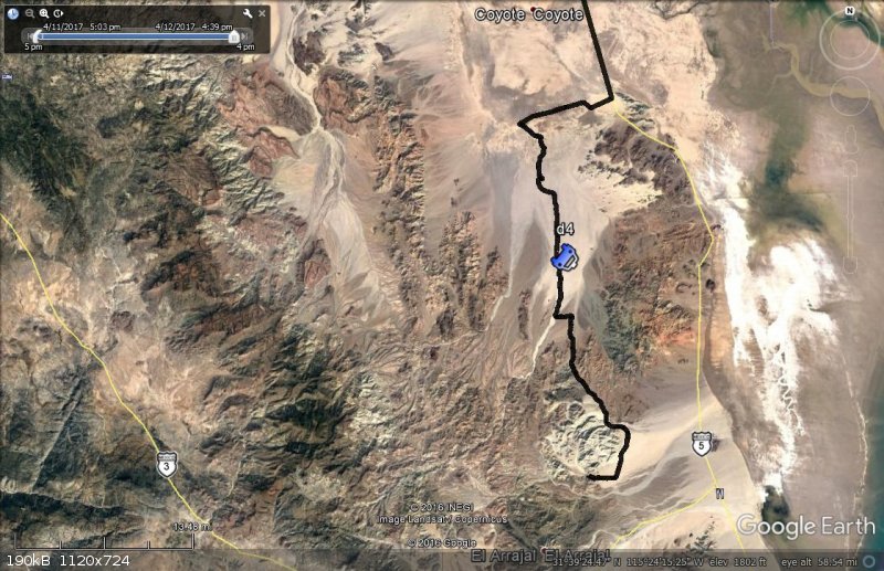
This is the image you posted for the drive from camp 3 to 4.
This is the SCORE race course from Arroyo Grande to Hwy 3
|
|
|
Fatboy
Senior Nomad
Posts: 711
Registered: 6-28-2005
Member Is Offline
|
|
Yep, that is what I thought you meant but it went with my comments regarding driving up an East/West flowing wash that the course crosses at right
angles.
Thanks for clarify this.
The reason it I was wondering is the valley I hiked in showed such little human use and it felt almost special in there.
This valley is west of the start of the black line on my map (not the end which is labeled D4 and has a little upside down car icon).
|
|
|
PaulW
Ultra Nomad
Posts: 3005
Registered: 5-21-2013
Member Is Offline
|
|
there are two e/w significant drainage's that cross the race track in toms pic. The southern most is Arroyo Arrajal and the northern most is faint on
the topos. I also will do an end run from A Arrajal into a nw leading side wash and start my hike way west of 4 corners.
North of Pinta Pass - nothing just the multiple north and northeast down flows from the Pintas. Anyway I have doubts it Henderson was north of Pinta
Pass. My plan is to spend time on those two E/W water paths south of PP.
Fatboy Sending u2u
[Edited on 6-3-2017 by PaulW]
|
|
|
David K
Honored Nomad
Posts: 64478
Registered: 8-30-2002
Location: San Diego County
Member Is Offline
Mood: Have Baja Fever
|
|
Thanks, Fatboy, Paul, and Tom.
The weather is cooling back down which opens up possible explorations into the Sierra Pinta once again.
Fatboy, can you tell me why (on the lower black line) you turned around there? Is it possible to drive further west (and northwest) from the end of
the lower (south) black line?
Thank you for sharing your search for Henderson's Rockpile and/or the Lost Grave of a Spanish Explorer, Captain Melchior Diaz, 1541... the first
European to enter California using land routes rather than ships.

|
|
|
| Pages:
1
2 |


