Chucho
Newbie
Posts: 7
Registered: 2-6-2017
Member Is Offline
|
|
Ojos Negros to Valle de Guadalupe?
Hi!
Sorry if this question has been asked before but a quick search did not give me any results.
Anyway, I am going to be on a 3-day motorcycle ride with friends and was wondering if there is a route/road/way to get from Ojos Negros (Cava de
Marcelo) to Valle de Guadalupe (La Casa de Doña Lupe) other than the highway.
Thanks!
Chucho
|
|
|
Howard
Super Nomad

Posts: 2346
Registered: 11-13-2007
Location: Loreto/Manhattan Beach/Kona
Member Is Offline
Mood: I'd rather regret the things I've done than regret the things I haven't done.
|
|
David K, are you OK?
It's been a couple of hours and there has been no response with some maps! 
David, we are very concerned about your welfare!
Chucho, someone will be along and give you some guidance.
[Edited on 6-20-2017 by Howard]
We don't stop playing because we grow old;
we grow old because we stop playing
George Bernard Shaw
|
|
|
David K
Honored Nomad
Posts: 64479
Registered: 8-30-2002
Location: San Diego County
Member Is Offline
Mood: Have Baja Fever
|
|
Thank you for your concern, Howard.
I was actually reading past posts here on Nomad looking for an answer.
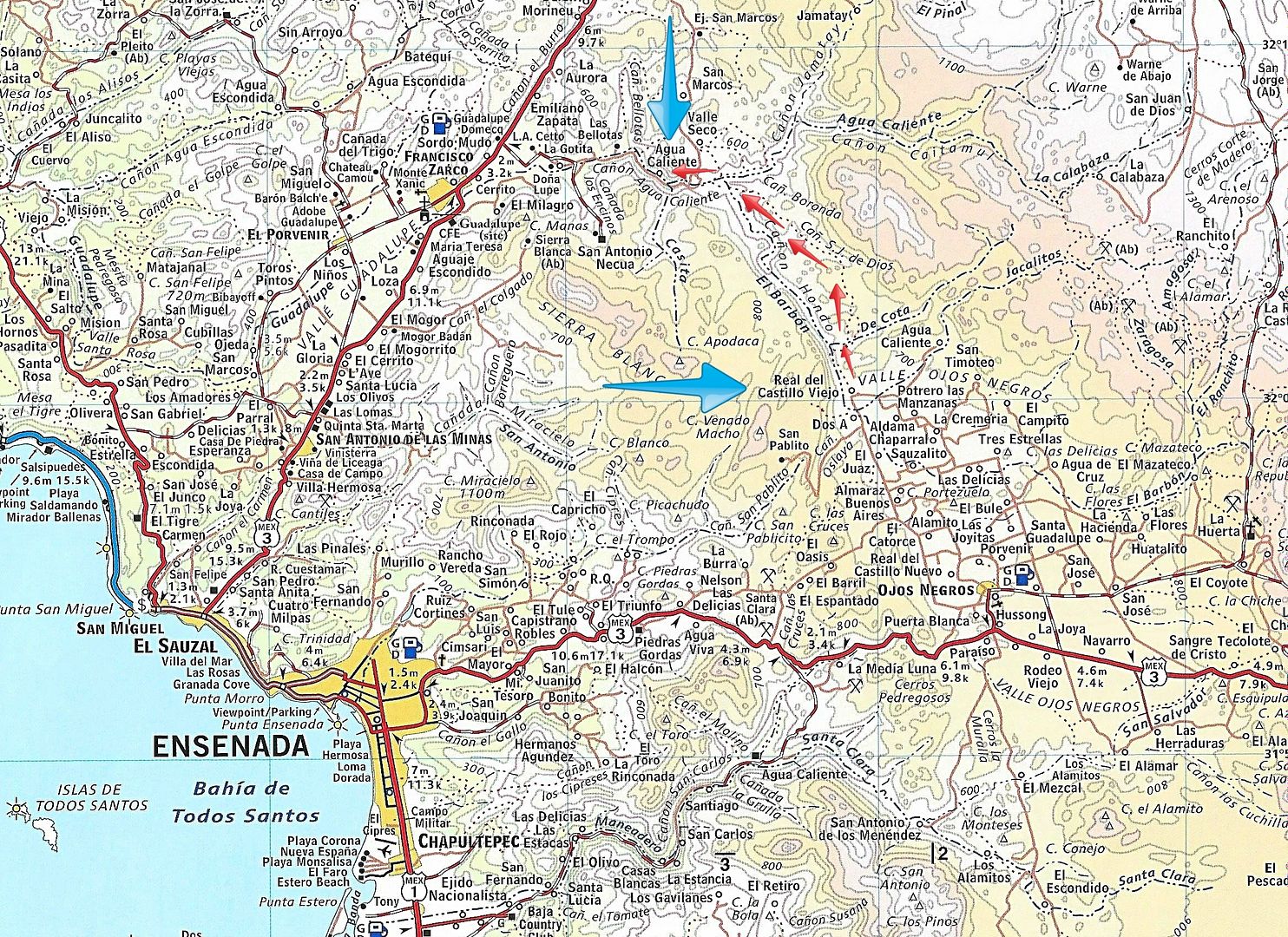
In short, there may be a road between the Russian Valley Hot Springs (Las Cascadas, Agua Caliente, Federico's) to Real del Castillo, which is
connected to Ojos Negros. However, locked gates may block the way?
=============================================================
EDIT:
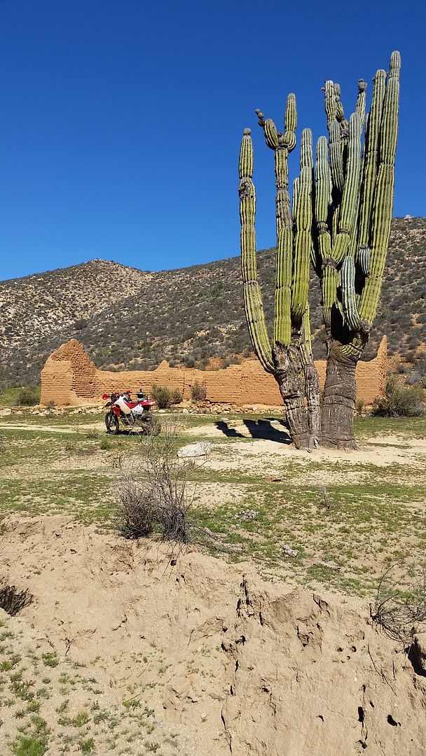
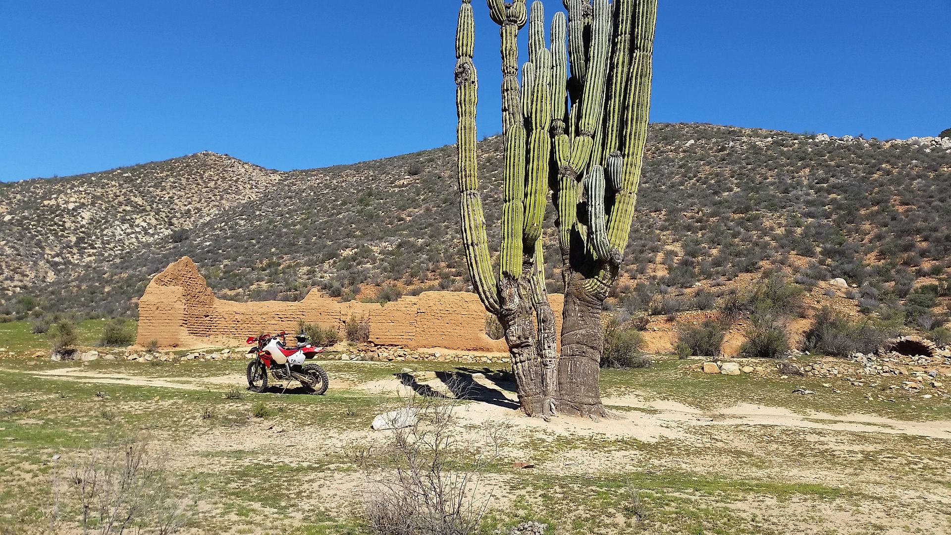
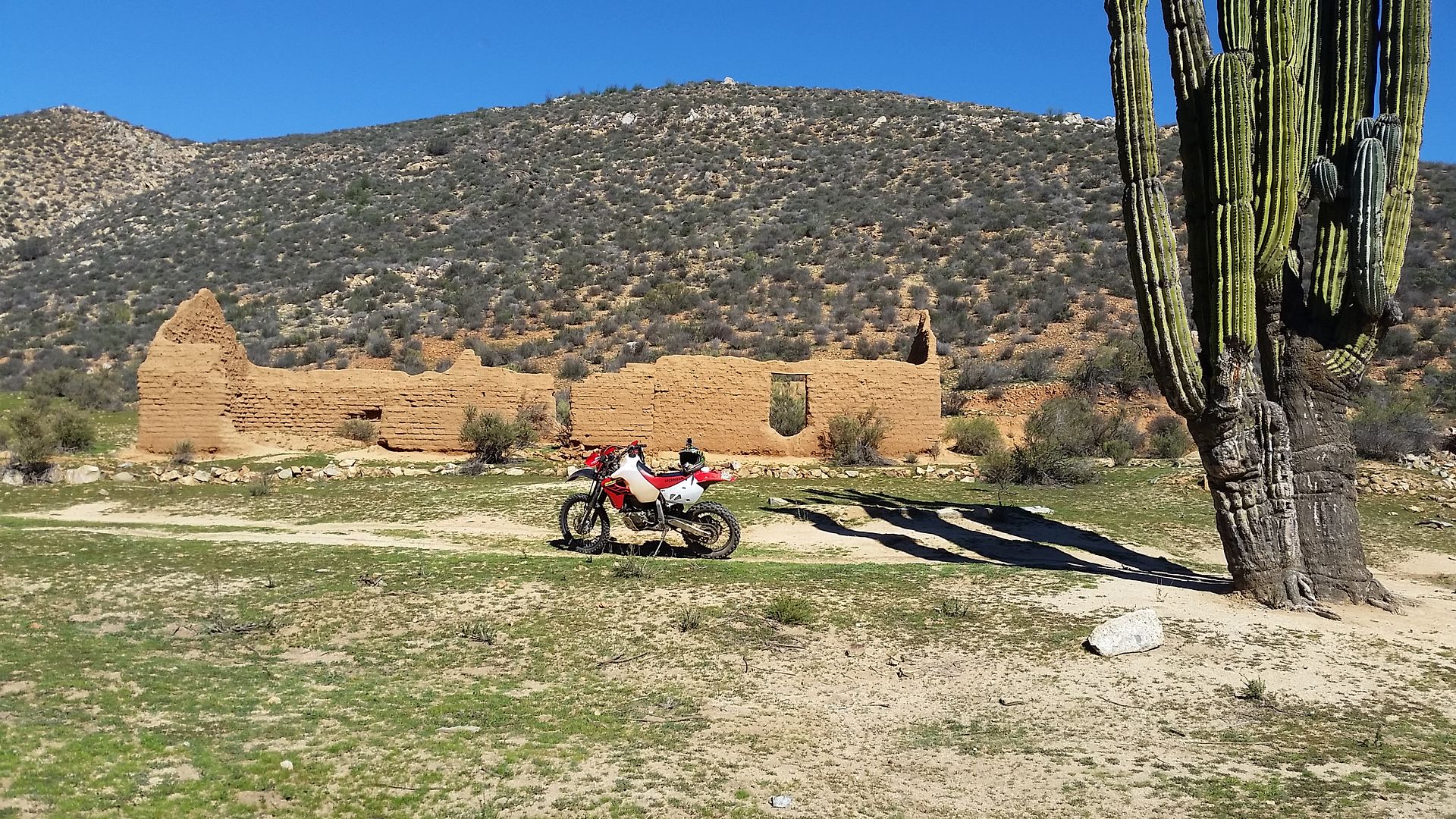
Here is something I was emailed to post on Nomad, back in 2015 when Baquito showed the adobe ruin and cardón photo here: http://forums.bajanomad.com/viewthread.php?tid=57653
Here was that email (edited for spelling):
I was sent this note and photos of this site this morning...
"Was riding a trail between Ojos Negros and Valle de Guadalupe over the weekend and came across this. I am assuming its old race
course because of the occasional orange arrow. I am more curious than anything about the history. I do not have a lat and lon but it's easy to spot
from GE. There is s dry well approx 40 feet deep in front and the structure sits on top of a nice bluff overlooking a stream. ( 2 feet deep running
water on super bowl Sunday ) thanks. Feel free to share on Baja Nomads if it's worthy. I commend you on your dedication to Baja. Thanks, Michael."
[Edited on 6-20-2017 by David K]
|
|
|
David K
Honored Nomad
Posts: 64479
Registered: 8-30-2002
Location: San Diego County
Member Is Offline
Mood: Have Baja Fever
|
|
A trail is between the two arrows (hot springs and Real del Castillo) on the 2009 Baja Almanac, on the right side of the canyon:
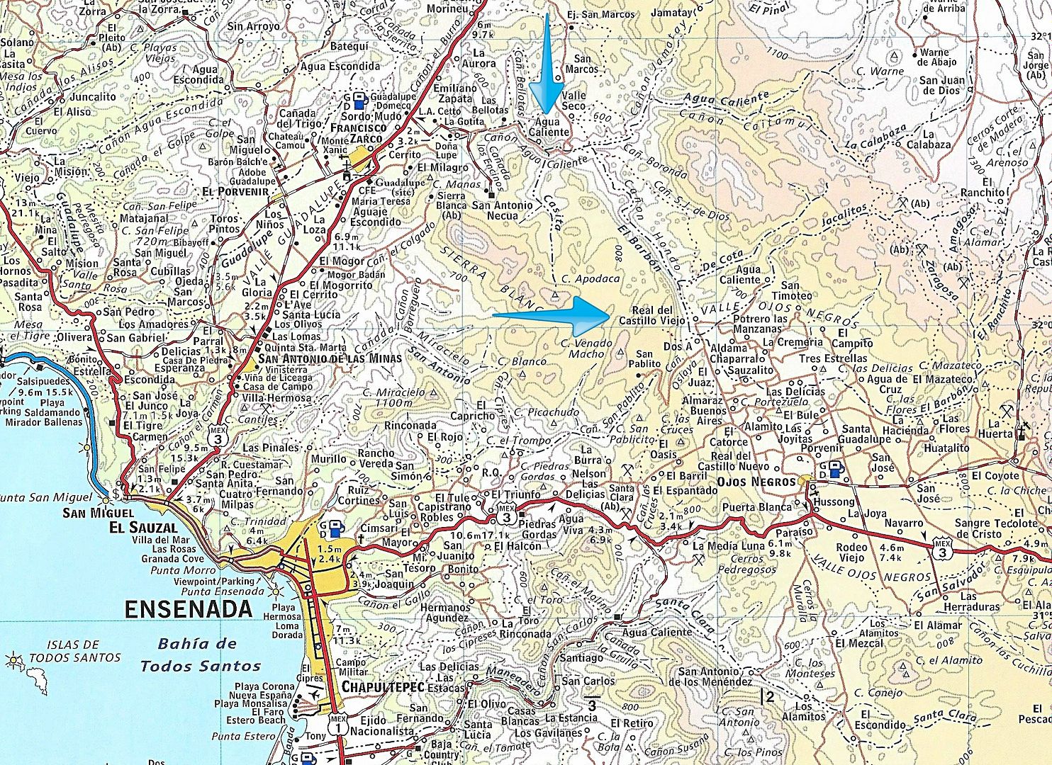
Google Earth or Bing will be better to look for roads but gates won't show.
[Edited on 6-22-2017 by David K]
|
|
|
bajaguy
Elite Nomad
Posts: 9247
Registered: 9-16-2003
Location: Carson City, NV/Ensenada - Baja Country Club
Member Is Offline
Mood: must be 5 O'clock somewhere in Baja
|
|
Cucho
They are attempting to push through the bypass road from Hwy 3 (Ojos Negros side) to Hwy 3 (the Tecate route). It is paved about 1/4 of the way east
from the Tecate side and I know they were building several bridges and grading the route. You may be able to make it through between the two hwy 3
sections, however I'm not sure about a direct dirt road/trail
|
|
|
TMW
Select Nomad
Posts: 10659
Registered: 9-1-2003
Location: Bakersfield, CA
Member Is Offline
|
|
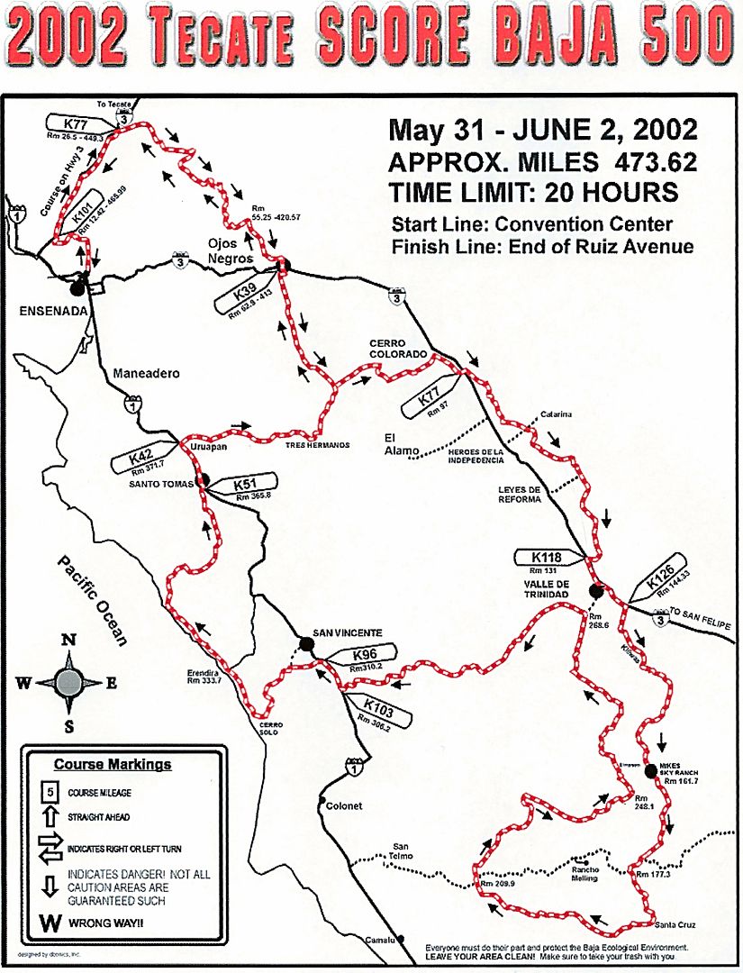
Score used a road a couple of times for the 500 race.
|
|
|
TMW
Select Nomad
Posts: 10659
Registered: 9-1-2003
Location: Bakersfield, CA
Member Is Offline
|
|
SCORE used it in the 2000-2002 Baja 500 races. Murdock has GPS files and a KML file for Google Earth.
http://www.murdocknav.com/mapsmex1.php
|
|
|
David K
Honored Nomad
Posts: 64479
Registered: 8-30-2002
Location: San Diego County
Member Is Offline
Mood: Have Baja Fever
|
|
Thanks, Tom!
|
|
|
Chucho
Newbie
Posts: 7
Registered: 2-6-2017
Member Is Offline
|
|
Thanks all for your responses and good sense of humor!
bajaguy, for this trip I will be wearing a shirt with the same picture as your avatar. What a coincidence, eh?
DavidK, I am not too fond of bumper stickers; actually, the only one that I have ever put on any of all my vehicles is a "Viva Baja" I found in a
geocache some time around 2006...
TMW, I wasn't aware about the Murdock website - it is excellent site with a bunch of info. I was able to download the PDF map and the KML file for the
2002 Baja 500 and the track is there. Thanks!
-Chucho
|
|
|
bajaric
Senior Nomad
Posts: 602
Registered: 2-2-2015
Member Is Offline
|
|
Actually, the BCA does show a trail from Real de Castillo Viejo to Agua Caliente. It is a dotted line that directly connects them, hard to see
because the dots are is partly concealed in the Canyon Agua Caliente. The trail skirts the Arroyo Hondo "deep arroyo". Would love to explore that
area some day, on the bucket list. Thanks for the posting of the adobe, interesting, could be from the 1800's when Real de Castillo was a boom town.
|
|
|
del mar
Banned
Posts: 1057
Registered: 7-23-2016
Location: the cantina of course
Member Is Offline
Mood: lil' fuzzy
|
|
the Nat Geo map also shows the road but doesn't show it actually connect thru the stream bed in the middle.
[Edited on 6-21-2017 by del mar]
|
|
|
TMW
Select Nomad
Posts: 10659
Registered: 9-1-2003
Location: Bakersfield, CA
Member Is Offline
|
|
Just be aware that there may be locked gates causing you to turn around. Check the routes on Google Earth and pick a couple of different ones just in
case. Carry enough gas in case you do have to turn around or have a chase truck follow you.
|
|
|
David K
Honored Nomad
Posts: 64479
Registered: 8-30-2002
Location: San Diego County
Member Is Offline
Mood: Have Baja Fever
|
|
GREAT EYES!
Quote: Originally posted by bajaric  | | Actually, the BCA does show a trail from Real de Castillo Viejo to Agua Caliente. It is a dotted line that directly connects them, hard to see
because the dots are is partly concealed in the Canyon Agua Caliente. The trail skirts the Arroyo Hondo "deep arroyo". Would love to explore that
area some day, on the bucket list. Thanks for the posting of the adobe, interesting, could be from the 1800's when Real de Castillo was a boom town.
|
Thanks for spotting that trail! It would seem it is not related to the Baja 500 route of 2002?
I added red arrows along it >>>
|
|
|


