| Pages:
1
2 |
TheEL
Newbie
Posts: 9
Registered: 7-18-2017
Member Is Offline
|
|
Recommendations en route to San Juanico
Hi all,
First time poster, long time lurker.
Have been down to Ensenada area numerous times but we are taking a trip down to San Juanico in the next couple of weeks and was just looking for
recommendations for things to do/see, places to camp, food to eat, etc... on the way down.
Leaving from LA. Not in a rush to get down there. More prone to the coastal roads. Have an AWD van with clearance so not shy of some dirt roads
either.
Thanks in advanced. Love all the info here.
|
|
|
Ateo
Elite Nomad

Posts: 5847
Registered: 7-18-2011
Member Is Offline
|
|
Like the name TheEl.
I'm headed that way in a few days myself.
If you like forests, I highly recommend the San Pedro Martir area. There is an observatory at 9,000' and views to San Felipe. And California
Condors.
On the coast, fun camping at Punta Cabras north of Erendira.
On the way to San Juanico, there's always Punta Abreojos area for surf and exploring.
Message me for more if you have questions.
Have fun.
[Edited on 7-19-2017 by Ateo]
|
|
|
David K
Honored Nomad
Posts: 64480
Registered: 8-30-2002
Location: San Diego County
Member Is Offline
Mood: Have Baja Fever
|
|
The old Spanish California missions can entertain and enlighten you as you follow El Camino Real back to where California began, at Loreto.
Indian rock art sites, old mines, beautiful beaches, and the palm filled oasis sites add to make Baja the most interesting peninsula on earth!
See the Trip Reports and Road Conditions forums here on Nomad along with my site, www.vivabaja.com for travel details. Click the link to my BajaBound.com travel adventure articles, as well.
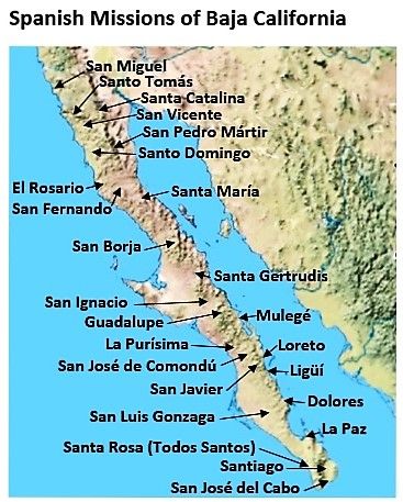
NORTH to SOUTH:
Right next to, or within 5 miles of Highway 1: San Miguel, Santo Tomás, San Vicente, Santo Domingo, El Rosario (2 sites), San Ignacio, Mulegé,
Loreto, Ligüí (no ruins), La Paz (no ruins), Santiago (modern church), San José del Cabo (modern church).
[Edited on 7-19-2017 by David K]
|
|
|
BajaGeoff
Super Nomad
Posts: 1727
Registered: 1-11-2006
Location: San Diego and Campo Lopez
Member Is Offline
Mood: Heading To Baja!!!
|
|
Another fun and relatively easy side trip off the highway is to go visit the cave paintings at mesa el Carmen. Article, photos and info is here:
https://www.bajabound.com/bajaadventures/bajatravel/painted_...
|
|
|
brewer
Nomad
Posts: 419
Registered: 1-4-2011
Location: BCS
Member Is Offline
Mood: Grateful
|
|
Very cool, thanks for that.
|
|
|
David K
Honored Nomad
Posts: 64480
Registered: 8-30-2002
Location: San Diego County
Member Is Offline
Mood: Have Baja Fever
|
|
Please enjoy a look at my other Baja articles published by Baja Bound: https://www.bajabound.com/bajaadventures/bajatravel/
|
|
|
TheEL
Newbie
Posts: 9
Registered: 7-18-2017
Member Is Offline
|
|
Wowzers. Thanks for all the info!
Ateo, definitely going to check out Punta Cabras. Looks like a great stopping point. Had Punta Abrejos on the list, heard good things already.
Would love to check out the painted caves. Seems like a place where you can actually "feel" the history there.
Couple more questions for everyone.
Whats gas availability like right now? Will have an extra 10 gallons with me but still... Also, do most of them only take pesos?
Whats the best way to get current info on the north road to San Juanico? Seems like talking to people in San Ignacio would get you the most up to date
info?
[Edited on 7-22-2017 by TheEL]
|
|
|
TMW
Select Nomad
Posts: 10659
Registered: 9-1-2003
Location: Bakersfield, CA
Member Is Offline
|
|
There is no problems with gas. The area from El Rosario to Jesus Maria north of Guerrero Negro there are no gas stations but there are people selling
gas out of barrels at Catavina and the LA Bay turn off. If you fill up at El Rosario you'll be OK.
Gas stations will take dollars and usually have a conversion sign posted. Best to use pesos as that is what is on the pump so no need to convert. When
converting sometimes numbers get mixed up, if you know what I mean.
The north road is not hard to follow. As you go out of San Ignacio it is paved for about 25+ miles then turns into a graded road. About 4.5 miles
after the pavement ends there is a sign on the left side (maybe in the middle I forget) at the fork go left. Another 5 miles you will bear left again
at a curve. Another 1.5 miles you'll pass the trash dump on your left. Just over 3 miles from the trash dump the road splits, go right for the salt
flats or left to high road but that gets a little complicated if you don't know where to go. Anyway go right to El Datil. Just stay on the most used
road section as there are many. They all go to the same place you just don't want to go thru any water. I repeat "STAY OUT OF THE MUD AND WATER"
unless you have a lot of time to stay there.
In El Datil go thru to almost the end of town and turn left and it will take you to more salt flats. You'll see the road, Stay on the most used road
and it will take you to some sand sections and by a white rock mountain on your right, that is volcanic ash by the way. The road will turn into a
graded road and will dead end at the graded road to San Juanico.
I can do some Google Earth images with GPS readings if you want them.
[Edited on 7-22-2017 by TMW]
|
|
|
honda tom
Nomad
Posts: 493
Registered: 8-28-2003
Location: middle calif
Member Is Offline
|
|
north road is good. read tmw's directions and compare them to a google earth image. remember to always head to el datil, youll be fine. a fun side is
to head out to the pacific at santa rosalita (hour south of bay of la turnoff) hit the pacific and turn south for 20+or- miles of pacific. this route
meets back with hwy 1, see google earth.
have fun
|
|
|
BigWooo
Senior Nomad
Posts: 579
Registered: 1-2-2007
Member Is Offline
|
|
Although I haven't personally traveled the N. Road in a very long time, talking to new arrivals I'm told the washboard and exposed rock is as bad as
it gets. Especially on the middle road and from Las Ballenas to San Juanico.
Going is slow. Super high tides are affecting the salt flats.
|
|
|
Ateo
Elite Nomad
Posts: 5847
Registered: 7-18-2011
Member Is Offline
|
|
Depending on when you're leaving, I can caravan in with you to Datil and Juanico.
|
|
|
mtgoat666
Select Nomad
Posts: 17296
Registered: 9-16-2006
Location: San Diego
Member Is Online
Mood: Hot n spicy
|
|
Quote: Originally posted by TMW  | There is no problems with gas. The area from El Rosario to Jesus Maria north of Guerrero Negro there are no gas stations but there are people selling
gas out of barrels at Catavina and the LA Bay turn off. If you fill up at El Rosario you'll be OK.
Gas stations will take dollars and usually have a conversion sign posted. Best to use pesos as that is what is on the pump so no need to convert. When
converting sometimes numbers get mixed up, if you know what I mean.
The north road is not hard to follow. As you go out of San Ignacio it is paved for about 25+ miles then turns into a graded road. About 4.5 miles
after the pavement ends there is a sign on the left side (maybe in the middle I forget) at the fork go left. Another 5 miles you will bear left again
at a curve. Another 1.5 miles you'll pass the trash dump on your left. Just over 3 miles from the trash dump the road splits, go right for the salt
flats or left to high road but that gets a little complicated if you don't know where to go. Anyway go right to El Datil. Just stay on the most used
road section as there are many. They all go to the same place you just don't want to go thru any water. I repeat "STAY OUT OF THE MUD AND WATER"
unless you have a lot of time to stay there.
In El Datil go thru to almost the end of town and turn left and it will take you to more salt flats. You'll see the road, Stay on the most used road
and it will take you to some sand sections and by a white rock mountain on your right, that is volcanic ash by the way. The road will turn into a
graded road and will dead end at the graded road to San Juanico.
I can do some Google Earth images with GPS readings if you want them.
[Edited on 7-22-2017 by TMW] |
Ya, just stick to most-used road. Good luck figuring out which is most-used! 
If a hurricane comes thru, don't plan on the mud drying out for a month or 3 
|
|
|
woody with a view
PITA Nomad
Posts: 15937
Registered: 11-8-2004
Location: Looking at the Coronado Islands
Member Is Offline
Mood: Everchangin'
|
|
And most important of all - if you come to a sketchy place in the road just stand on the gas! Don't be a pussy!
|
|
|
AKgringo
Elite Nomad
Posts: 5809
Registered: 9-20-2014
Location: Anchorage, AK (no mas!)
Member Is Online
Mood: Retireded
|
|
The first time I traveled that salt flat heading south, was in 2014 just before the Baja 1k, and apparently at a high tide cycle. A water crossing
was unavoidable.
There was also a stiff onshore breeze, and drifting sand obscured the 'most traveled' route. I wound up following a track that was blazed by trophy
trucks trying to find the way to El Datil.
I barely made it through where I crossed, but could not find a connection to the main road, so I backtracked to where I crossed. I spent the next
couple of hours helping a local produce vendor get his loaded truck back up on dry ground, He was fooled, and that is a regular route for him!
[Edited on 7-22-2017 by AKgringo]
If you are not living on the edge, you are taking up too much space!
"Could do better if he tried!" Report card comments from most of my grade school teachers. Sadly, still true!
|
|
|
TheEL
Newbie
Posts: 9
Registered: 7-18-2017
Member Is Offline
|
|
I'll make you proud!
From the sound of it I am definitely open to getting GPS coordinates for any recently traveled paths along the north road. Im not too worried but Id
feel like a fool to turn down a little help.
|
|
|
TheEL
Newbie
Posts: 9
Registered: 7-18-2017
Member Is Offline
|
|
Got back last Sunday but got slammed with work immediately upon return. Finally have some time to breath.
The gps track provided worked gangbusters. We had to help a dude in his 2wd toyota sequoia out of a rut in the soft sand near the cactus forest. My
AWD chevy van handled it all no problem. On the very last salt flat I took the wrong track and went through some deep mud/salt/silt/whatever you want
to call it. I made it out fine, luckily. My friend in his subaru outback did not...
Took us the better part of 2 hours to dig him out. A truck full of locals stopped to help, then 2 more cars stopped to help. We got very lucky.
Perhaps some good karma too from helping the other dude just a little while before. Lessons learned. ALWAYS take the edge of the salt flat it seems.
Bringing binoculars next time to scope out every route.
Really fun trip. Scored some fun waves. The north road spooked my friend in the subaru out so we took the long way back home. Another lesson learned.
Ill never camp on the east side in the middle of summer again. Im from Florida and that heat and humidity felt like a swift kick to the groin. Maybe
Ive gotten soft but that was the worst Ive ever felt.
Cant wait to get back down there and explore some more...
|
|
|
StuckSucks
Super Nomad
Posts: 2306
Registered: 10-17-2013
Member Is Offline
|
|
Have any photos to share?
|
|
|
woody with a view
PITA Nomad
Posts: 15937
Registered: 11-8-2004
Location: Looking at the Coronado Islands
Member Is Offline
Mood: Everchangin'
|
|
Ha, you're getting soft!
|
|
|
TheEL
Newbie
Posts: 9
Registered: 7-18-2017
Member Is Offline
|
|
Heres a couple. Im not sure why they are posting so large...


|
|
|
PaulW
Ultra Nomad
Posts: 3005
Registered: 5-21-2013
Member Is Offline
|
|
Why is this thread overflowing my screen?
Do we still have a software issue?
|
|
|
| Pages:
1
2 |


