| Pages:
1
2
3 |
TMW
Select Nomad

Posts: 10659
Registered: 9-1-2003
Location: Bakersfield, CA
Member Is Offline
|
|
San Juanico North Road
Since many have asked about the north road to San Juanico I've put together some Google Earth images and will add some GPS way points. The paved road
out of San Ignacio is 25+ miles and ends at the mud flats. From there it is a graded road past the trash dump to the Y for El Datil. From the Y into
El Datil the road crosses what is known as the salt flats. It is very important that you stay on the most traveled road. STAY OUT OF THE MUD AND
WATER. From El Datil you again will be on the salt flats then on a sand road before it turns into a graded road. It dead ends at the graded road that
is referred to as the high road. This graded road runs south to San Juanico.
The high road use to be the main road years ago but silt beds and rain have taken it toll over the years. Martin Sr the owner of Rancho El Cuarenta
told me a couple of years ago that north of his place the road was wiped out. There is a cut across road that runs from Rancho El Cuarenta to Los
Batequis. There are some soft sand spots on it so a 4x4 is highly recommended.
If you use the north road by way of Rancho El Cuarenta Martin or a member of his family will give you a piece of paper asking for donations.
Batteries especially AA and AAA are always welcome there.
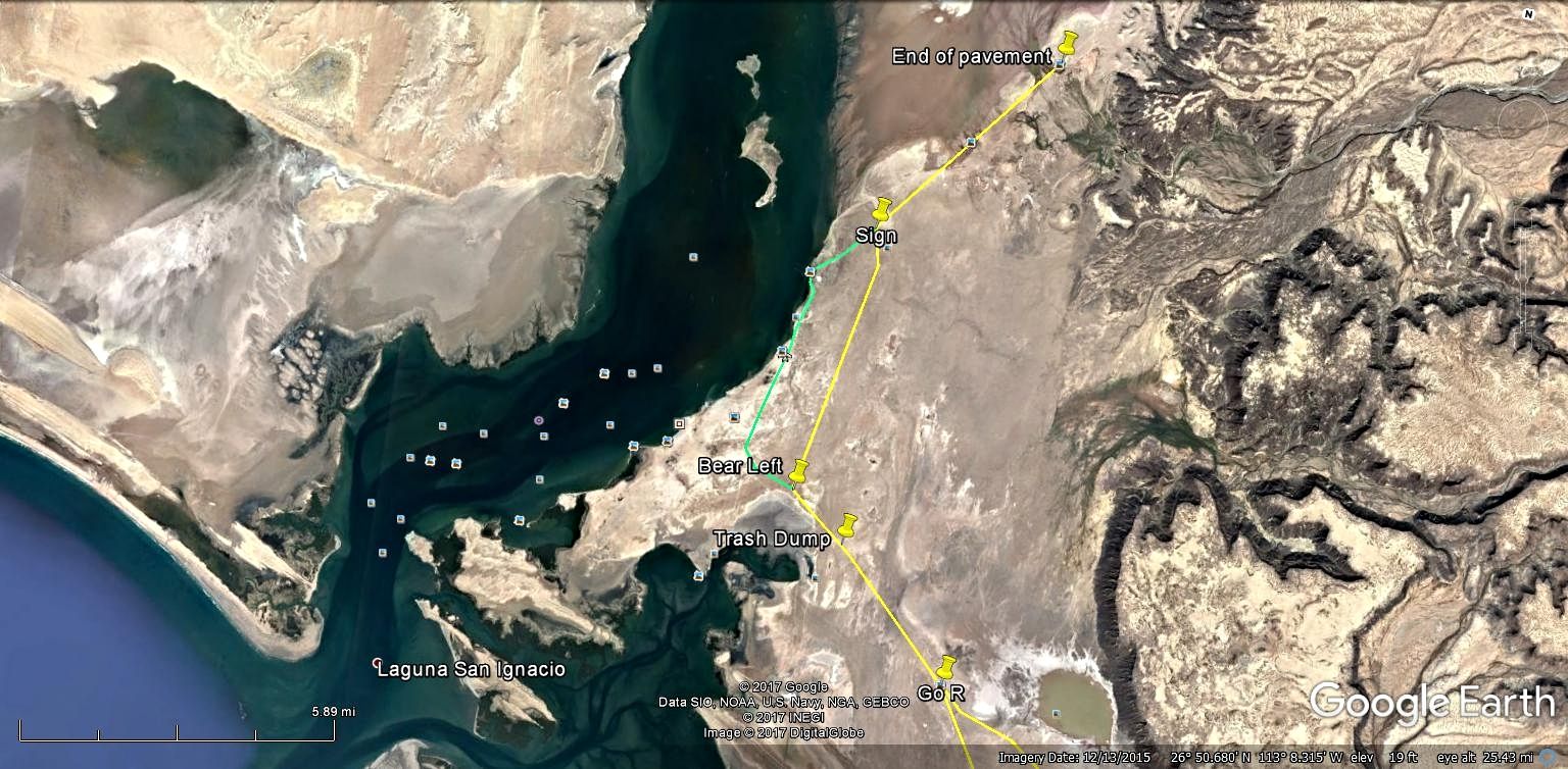
Sign is at 26-53.420x113-07.100
Trash dump is at 26-48.254x113-06.843
The Y for El Datil is 26-46.232x113-04.645
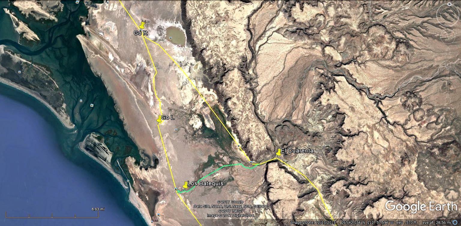
There are two turn offs to Los Batequis the second one is at
26-36.624x113-00.420
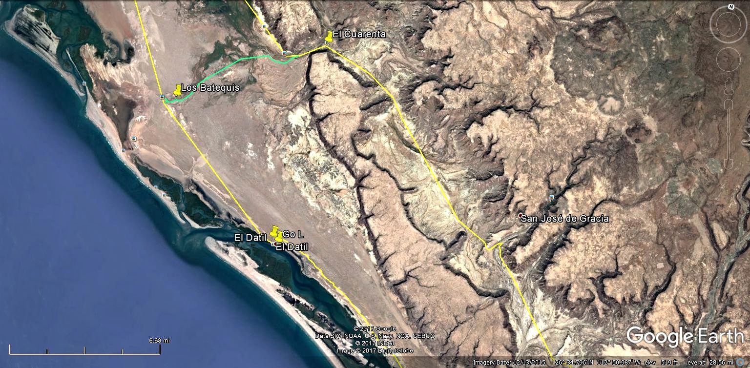
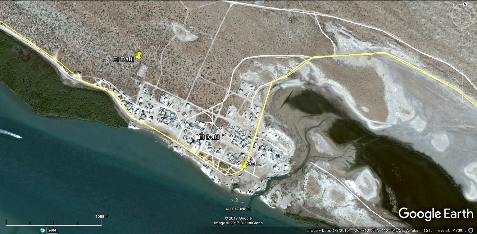
El Datil is a pretty simple fishing village, If needed they have gas out of barrels
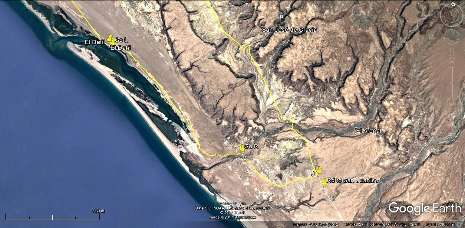
After leaving El Datil the road goes from salt flats to sand. You'll pass a ranch on your left, it may be abandoned I don't recall. After the ranch
turn right and cross an arroyo. To your right is a mountain of white volcanic ash. The road turns into a graded road and dead ends at the graded road
to San Juanico, go right.
Right turn after the ranch is 26-26.630x112-44.810
T junction to San Juanico is 26-26.000x112-39.370
[Edited on 7-22-2017 by TMW]
|
|
|
David K
Honored Nomad
Posts: 64476
Registered: 8-30-2002
Location: San Diego County
Member Is Offline
Mood: Have Baja Fever
|
|
Thank you Tom.
Is high tide around new or full moon phases always going to flood the road or is that just a rare high tide issue?
|
|
|
TMW
Select Nomad
Posts: 10659
Registered: 9-1-2003
Location: Bakersfield, CA
Member Is Offline
|
|
I've never had an issue of the road flooding while driving thru there. That said I can't say if it is a regular problem or not. I've seen water to the
sides. I would keep an eye on my rear view mirror and if you see mud being kicked up stop and back up. If necessary take the high road by way of El
Cuarenta. There are several lines going thru there and I always take the one most used.
As a side note SCORE in 2010 and NORRA this year used a road coming off the San Ignacio paved road that goes to El Patrocino and and around coming
into the back side of El Cuarenta.
|
|
|
mcnut
Nomad
Posts: 177
Registered: 12-9-2013
Location: Dammeron Valley, UT
Member Is Offline
|
|
Excellent, best directions and info for those routes even though many have tried.
Bruce
|
|
|
AKgringo
Elite Nomad
Posts: 5805
Registered: 9-20-2014
Location: Anchorage, AK (no mas!)
Member Is Offline
Mood: Retireded
|
|
Quote: Originally posted by TMW  | I've never had an issue of the road flooding while driving thru there.
As a side note SCORE in 2010 and NORRA this year used a road coming off the San Ignacio paved road that goes to El Patrocino and and around coming
into the back side of El Cuarenta. |
TMW, as I posted in a reply to another post, I encountered flooding on the lower road in 2014.
My first time through San Juanico was traveling north on my return trip in 2013. I missed the turn off to El Datil, and thought I was on the high
road. It became clear after a while that the ranch road I was on was not going to return to the coast, but I had plenty of fuel and kept on driving.
I wound up intersecting the road you mentioned, somewhere south of Tres Palmas. There was a road crew there, and I showed them my AAA map and they
pointed out where I was, and told me there was no road where I just came from!
The ranch road was narrow and rugged, but I really didn't need 4x4. I also tried the old road headed toward the salt flats from Tres Palmas, but it
was alternately washed out, or overgrown to the point of being impassable.
I opened, then closed behind me, a couple of livestock gates, but there were no signs posted of any kind.
If you are not living on the edge, you are taking up too much space!
"Could do better if he tried!" Report card comments from most of my grade school teachers. Sadly, still true!
|
|
|
TheEL
Newbie
Posts: 9
Registered: 7-18-2017
Member Is Offline
|
|
Silly question probably, but Im having trouble figuring out how to map the coordinates given. Can anyone shine a light as to how to properly input
them into google maps?
|
|
|
AKgringo
Elite Nomad
Posts: 5805
Registered: 9-20-2014
Location: Anchorage, AK (no mas!)
Member Is Offline
Mood: Retireded
|
|
| Quote: Originally posted by TheEL | | Silly question probably, but Im having trouble figuring out how to map the coordinates given. Can anyone shine a light as to how to properly input
them into google maps? |
Not me! I just confessed to getting lost with a Garmin and a paper map, It was like being a second lieutenant again!
If you are not living on the edge, you are taking up too much space!
"Could do better if he tried!" Report card comments from most of my grade school teachers. Sadly, still true!
|
|
|
TMW
Select Nomad
Posts: 10659
Registered: 9-1-2003
Location: Bakersfield, CA
Member Is Offline
|
|
On Google Earth where the cursor is located the coordinates are shown at the bottom right along with the image date, the land elevation and the eye
altitude. To change the coordination datum click on tools in the upper left then click options. A menu bar will open allowing you to select various
options. I usually use degrees, decimal minutes which is what most GPS devices use. If you use a spot device it sends the signal as decimal degrees.
|
|
|
mtgoat666
Select Nomad
Posts: 17284
Registered: 9-16-2006
Location: San Diego
Member Is Offline
Mood: Hot n spicy
|
|
| Quote: Originally posted by TheEL | | Silly question probably, but Im having trouble figuring out how to map the coordinates given. Can anyone shine a light as to how to properly input
them into google maps? |
The OP is sharing snapshots of what is in google earth. Perhaps the OP will share the raw data as a kml file, the standard output from google earth

|
|
|
mtgoat666
Select Nomad
Posts: 17284
Registered: 9-16-2006
Location: San Diego
Member Is Offline
Mood: Hot n spicy
|
|
put the file on Google Drive (or similar) in a "public" folder, and then provide the link here in message body.
|
|
|
mtgoat666
Select Nomad
Posts: 17284
Registered: 9-16-2006
Location: San Diego
Member Is Offline
Mood: Hot n spicy
|
|
| Quote: Originally posted by David K |
Can you provide the steps, and show what Google Drive or a Public Folder is?
Thanks! Tom asked me for help on this, but I have not done that before. |
Google drive works like Dropbox.
Get a google account (you already got one if you have a gmail account) - it's free.
Download google drive app to your computer, phone, tablet, etc.
On your PC or MacBook, google drive creates a folder on your hard drive. Whatever you drag/drop into that folder gets replicated in the cloud and all
your shared devices. You can set each sub folder with it's own permisssions. It's intuitive, little need to read instructions, and if you need those
they are out there on the web.
You should also get google docs and use googles spreadsheet and word processors. Pretty slick, and free too.
Try google photos too. Pretty good saharing spot, and unlimited storage if you follow the resizing rules.
While you are at it, get google plus.
|
|
|
David K
Honored Nomad
Posts: 64476
Registered: 8-30-2002
Location: San Diego County
Member Is Offline
Mood: Have Baja Fever
|
|
OK, thank you, Mr. Goat... Nice of you to help.
I do have two Google email accounts, and they are my least favorite to use... One is for book sales. I will try this with my other Google email
account and see if I can replicate your steps.
I have grandpa duty this week, so it may take me a while longer than my typical muy rápido response time.
[Edited on 7-26-2017 by David K]
|
|
|
TMW
Select Nomad
Posts: 10659
Registered: 9-1-2003
Location: Bakersfield, CA
Member Is Offline
|
|
There you go David spoiling her.
|
|
|
mtgoat666
Select Nomad
Posts: 17284
Registered: 9-16-2006
Location: San Diego
Member Is Offline
Mood: Hot n spicy
|
|
| Quote: Originally posted by David K | | Quote: Originally posted by mtgoat666 |
Google drive works like Dropbox.
Get a google account (you already got one if you have a gmail account) - it's free.
Download google drive app to your computer, phone, tablet, etc.
On your PC or MacBook, google drive creates a folder on your hard drive. Whatever you drag/drop into that folder gets replicated in the cloud and all
your shared devices. You can set each sub folder with it's own permisssions. It's intuitive, little need to read instructions, and if you need those
they are out there on the web.
You should also get google docs and use googles spreadsheet and word processors. Pretty slick, and free too.
Try google photos too. Pretty good saharing spot, and unlimited storage if you follow the resizing rules.
While you are at it, get google plus.
|
OK, I have Google Drive.
I downloaded the app to sync with my PC...
When I go to the email from TW with the KMZ files, I can either download them or send them to One Drive... there is no option to send it to Google
Drive... ?
In Documents, same story, a list of places I can send it, like Drop Box but nothing for Google Drive.
[Edited on 7-25-2017 by David K] |
Dude, you grandpas should ask for computer assistance from your younger family members 
if you are on a PC and Google Drive is running, you probably have an icon for it in the control bar at bottom (or side) of your desktop screen. click
it, should give you an option to view google drive on your local hard drive or the web.
life with files is simplest when you can drag-drop in windows explorer
[Edited on 7-25-2017 by mtgoat666]
|
|
|
David K
Honored Nomad
Posts: 64476
Registered: 8-30-2002
Location: San Diego County
Member Is Offline
Mood: Have Baja Fever
|
|
OK, well I thought I was asking (you or other Nomads) by posting here.
|
|
|
Mexitron
Ultra Nomad
Posts: 3397
Registered: 9-21-2003
Location: Fort Worth, Texas
Member Is Offline
Mood: Happy!
|
|
Nice report TMW, thanks!
|
|
|
Ateo
Elite Nomad
Posts: 5847
Registered: 7-18-2011
Member Is Offline
|
|
I'll be on this road soon.......................
|
|
|
TMW
Select Nomad
Posts: 10659
Registered: 9-1-2003
Location: Bakersfield, CA
Member Is Offline
|
|
Ateo let us know the north road conditions. I was last on it in April. Next time I'm down there I plan to take the high road by way of El Cuarenta,
either going or coming. The last time I did the high road was 2013.
|
|
|
David K
Honored Nomad
Posts: 64476
Registered: 8-30-2002
Location: San Diego County
Member Is Offline
Mood: Have Baja Fever
|
|
Sorry, Tom, I couldn't progress beyond the Google Drive set up to share your KMZ files. Maybe MtGoat666 will help you more?
I will be on that road on my next trip as well. I will have a GPS track (hopefully) to show it here.
|
|
|
Ateo
Elite Nomad
Posts: 5847
Registered: 7-18-2011
Member Is Offline
|
|
Tom, I will give you a report when I get service.
|
|
|
| Pages:
1
2
3 |


