| Pages:
1
2
3 |
TMW
Select Nomad

Posts: 10659
Registered: 9-1-2003
Location: Bakersfield, CA
Member Is Offline
|
|
Thanks Ateo.
David the GE and GPX files are traced from GE. When you get to the salt flats just follow the best lines. As I said before stay out of the mud and
water. At the last Baja 1000 going that way the SCORE GPS route had them driving into mud and Billy Robertson, Tony Tellier and others got stuck
there, long time to get out.
|
|
|
David K
Honored Nomad
Posts: 64479
Registered: 8-30-2002
Location: San Diego County
Member Is Offline
Mood: Have Baja Fever
|
|
Quote: Originally posted by TMW  | Thanks Ateo.
David the GE and GPX files are traced from GE. When you get to the salt flats just follow the best lines. As I said before stay out of the mud and
water. At the last Baja 1000 going that way the SCORE GPS route had them driving into mud and Billy Robertson, Tony Tellier and others got stuck
there, long time to get out. |
I am not worried, thanks to your good directions. I thought you asked me how to post those links here and that is what I was trying to do, but without
a kid (or goat) to guide me to the next step, I was stymied. Look for my inReach tracking signal to begin at San Ignacio, next week.
|
|
|
TMW
Select Nomad
Posts: 10659
Registered: 9-1-2003
Location: Bakersfield, CA
Member Is Offline
|
|
Have a good trip DK. Following you is very interesting and your pictures are great.
|
|
|
David K
Honored Nomad
Posts: 64479
Registered: 8-30-2002
Location: San Diego County
Member Is Offline
Mood: Have Baja Fever
|
|
Thanks, Tom,
It is going to be the toughest, I think... At least I won't be cold as I was the evenings of my first two trips this year (New Years and February).
|
|
|
Sweetwater
Senior Nomad
Posts: 915
Registered: 11-26-2010
Member Is Offline
Mood: chilly today hot tomale
|
|
Returning to the On Topic discussion, I'm curious about the option of driving east out of Datil. I've taken the low road that continues along the
shore line and wonder how much san/silt lies on the eastern route?
Edit: That is by far the best and most informative post on this route that I've seen or read on multiple forums. Thanks.
[Edited on 7-26-2017 by Sweetwater]
Everbody\'s preachin\' at me that we all wanna git to heaven, trouble is, nobody wants to die to git there.-BB King
Reality is what does not go away when you stop believing in it. -Philip K Dick
Nothing is worse than active ignorance. Johann Wolfgang von Goethe(1749-1832, German writer, artist and politician)
When choosing between two evils, I always like to try the one I\'ve never tried before. - Mae West
Experience is what keeps a man who makes the same mistake twice from admitting it the third time around.
|
|
|
Tomas Tierra
Super Nomad
Posts: 1281
Registered: 3-23-2005
Location: oxnard, ca
Member Is Offline
Mood: Tengo Flojera
|
|
Finally pulling the trigger on the North road eh?? Spooky out there, be careful
|
|
|
Beagle
Nomad
Posts: 258
Registered: 10-25-2014
Location: Outer Rim
Member Is Offline
|
|
| Quote: Originally posted by Sweetwater | Returning to the On Topic discussion, I'm curious about the option of driving east out of Datil. I've taken the low road that continues along the
shore line and wonder how much san/silt lies on the eastern route?
Edit: That is by far the best and most informative post on this route that I've seen or read on multiple forums. Thanks.
[Edited on 7-26-2017 by Sweetwater] |
I could be wrong but they both just meet up a few KM down the road by looking at the map. Or I don't understand the question.
We took it a few weeks back. Taking a left once in town (Datil), you then pass a Vintage silver Spartan trailer that says "Laundry" on one side of it
and go down a ways and veer right again. We had mostly hard pack-salt. Had to stay on the eastern most edges to stay out of the wet though. Since then
I've heard it's gotten swamped over so I have no idea if that's the way to do right now.
People in San Ignacio will know the most up to date situation.
|
|
|
chippy
Super Nomad
Posts: 1695
Registered: 2-2-2010
Member Is Offline
|
|
Really its not that scary.
[Edited on 7-27-2017 by chippy]
[Edited on 7-27-2017 by chippy]
|
|
|
David K
Honored Nomad
Posts: 64479
Registered: 8-30-2002
Location: San Diego County
Member Is Offline
Mood: Have Baja Fever
|
|
Yep, as I have never had a reason to go to Scorpion Bay before, north, south or east roads. I was in La Purísima last Feb., so I pretty well got the
east road covered. Naturally, going over the mountain to/ from Mulegé is still in need for my curiosity!
|
|
|
TMW
Select Nomad
Posts: 10659
Registered: 9-1-2003
Location: Bakersfield, CA
Member Is Offline
|
|
| Quote: Originally posted by Sweetwater | Returning to the On Topic discussion, I'm curious about the option of driving east out of Datil. I've taken the low road that continues along the
shore line and wonder how much san/silt lies on the eastern route?
Edit: That is by far the best and most informative post on this route that I've seen or read on multiple forums. Thanks.
[Edited on 7-26-2017 by Sweetwater] |
I'm not sure what you mean by a road east of El Datil. There is a road 5 miles north of El Datil that goes east thru Los Batequis over to El Cuarenta.
Before El Cuarenta it connects with the high road going north, which use to be the main road.
Back in 1992 a friend and I pre-ran the area getting ready for the SCORE Baja 1000 race and here is a map I drew. Note not to scale. SCORE used a road
about 8-10 miles after the curve. I don't see that road on Google Earth today.
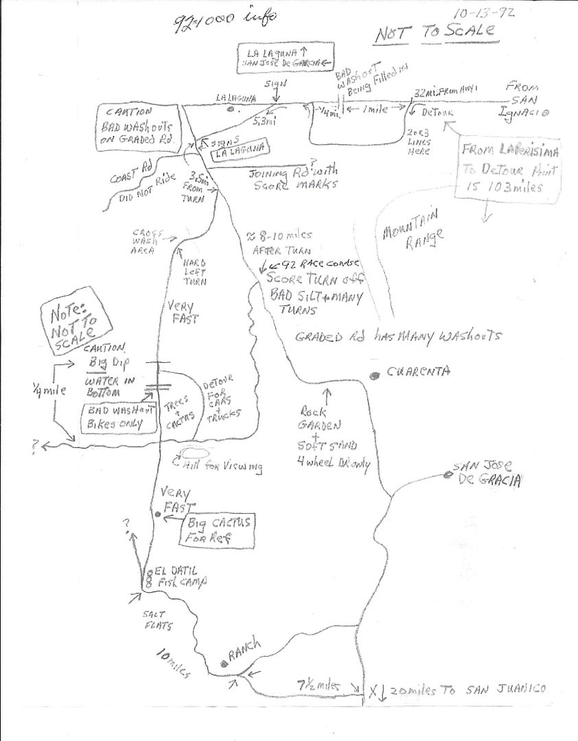
[Edited on 7-27-2017 by TMW]
|
|
|
Tomas Tierra
Super Nomad
Posts: 1281
Registered: 3-23-2005
Location: oxnard, ca
Member Is Offline
Mood: Tengo Flojera
|
|
| Quote: Originally posted by David K |
Yep, as I have never had a reason to go to Scorpion Bay before, north, south or east roads. I was in La Purísima last Feb., so I pretty well got the
east road covered. Naturally, going over the mountain to/ from Mulegé is still in need for my curiosity! |
North and east roads are well worth the effort.
On the North, Pull off in Datil and buy some gas and a beer at the store and hang out. That little village has some great people! And a very unique
vibe. One of the last places where the kids will still rush the truck screaming for stickers
TT
|
|
|
Tomas Tierra
Super Nomad
Posts: 1281
Registered: 3-23-2005
Location: oxnard, ca
Member Is Offline
Mood: Tengo Flojera
|
|
| Quote: Originally posted by Sweetwater | Returning to the On Topic discussion, I'm curious about the option of driving east out of Datil. I've taken the low road that continues along the
shore line and wonder how much san/silt lies on the eastern route?
Edit: That is by far the best and most informative post on this route that I've seen or read on multiple forums. Thanks.
[Edited on 7-26-2017 by Sweetwater] |
Agreed on the quality of info here.
The road east out of Datil is actually NW of Datil by about 5 miles. It's where the abandoned block house is with all the telephone poles.. You go
east towards the Mesa from there. You can see the el Quarenta "cut" in the Mesa with white bluffs. You go through the cut to get to el Quarenta ranch
TT
|
|
|
Ateo
Elite Nomad
Posts: 5847
Registered: 7-18-2011
Member Is Offline
|
|
I just did the exact route TMW laid out above. We had no issues. You definitely want to have 4x4 on this route because there are miles of sand before
you hit the cardon forest. Having said that I did it in years past in a 4x2 Tundra and didn't get stuck. The road from San Ignacio is paved about 30
miles and in great shape. Make the turns Tom motioned and hang a right at the dump and head out to Datil. You will
pass many sections where you can see signs of prior people getting stuck. (Sticks, debris, whatever you can find to try and gain traction and get
unstuck). We passed out stickers in Datil and found the salt flats pretty wet. Wetter than I've seen in the last few years. Maybe from recent high
tides or rain. Stay to the left on the flats and hug the mini dunes. All roads lead to the same place. Once connected back to the main north road I
was averaging about 50mph. The washboard wasn't that bad. Average for that stretch. Have fun. It took us about 3.5 hours. Scored some waves too!
|
|
|
David K
Honored Nomad
Posts: 64479
Registered: 8-30-2002
Location: San Diego County
Member Is Offline
Mood: Have Baja Fever
|
|
Good to hear from you Jon!
It was an extra high tide this past week with the moon in charge. This week it is a quarter moon, so lower tides.
|
|
|
David K
Honored Nomad
Posts: 64479
Registered: 8-30-2002
Location: San Diego County
Member Is Offline
Mood: Have Baja Fever
|
|
Camped south of El Datil in some beautiful sand dunes, last night (Wed).
Paving south of San Ignacio runs 30 miles, 5 miles from the lagoon shore and about 10 miles from Kuyima complex. There is quite a town just east to
drive through to rejoin the bypass road that brached before the lagoon.
The road on south to El Datil began as bad washboard after the Y (sign says Salina, go right fork), past the dump TW referenced. That bad washboard
was only for a short ways but got me to deflate my tires.
The salt flats were dry where the road was aling the east edge, until the southernmost section south of El Datil and that was because after hugging
the edge I finally cut across, as traffic had before. Not bad mud, but I used 4WD briefly.
The road from the salina up to the high road junction was graded, not fast and some rock sections. Thank you TW for the notes.
The graded road high road south to Cadeje and San Juanico was good and fast.
Paved road from San Juanico to Las Barrancas was good. New river crossing work ongoing.
Las Barrancas to La Purísima/Insurgentes highway junction had pot holes. The Purisima/Insurgentes highway only had a few bad miles. Most of it was
brand new, wide highway.
I will have more details in my TRIP #6 report.
|
|
|
David K
Honored Nomad
Posts: 64479
Registered: 8-30-2002
Location: San Diego County
Member Is Offline
Mood: Have Baja Fever
|
|
San Ignacio to San Juanico, August 2017
A road log... posting this from La Paz off my notes for your interest. I may make corrections or other edits when I am back home.
0.0 miles Mission San Ignacio, plaza.
0.6 Km.0 sign for hwy south, unpaved here.
0.7 Pavement begins...
8.4 Rancho San Juaquin
12.6 San Zacarias
18.8 El Patrocinio road jcn.
30.1 End of pavement
34.8 Fork, bypass left, San José de Garcia sign. Log continues to La Laguna, right fork.
36.1 Pancho's road to right.
36.2 Along lagoon shore.
38.8 Fork, right branch for Kuyima.
40.2 Intersection: Antonio's to right, Kuyima complex, straight 0.4 mi., La Laguna village and road south, turn left.
Reset odometer at Intersection.
0.7 La Laguna village
2.7 Junction with graded bypass road from mile 34.6 (above).
6.6 Fork, sign "Salina" for right branch. Ahead is the high road via San José de Garcia. Log continues on right branch via El Datil. Reset odometer
to 0.0
0 0 Salina road fork.
14.7 white building and dozens of tall poles used for osprey nests. A former desalinization project??
22.2 El Datil, fishing village.
31.9 Sand dunes access road right. Salt flat driving soon ends as road heads inland.
35.1 Ranch
35.4 Road bends to the right, crosses arroyo.
41.7 Junction with high road. Turn right/south.
46.7 Arroyo San Raymundo/Rancho La Ballena.
52.8 Cadeje, a small village.
61.0 Paved Highway at entrance to San Juanico 'Scorpion Bay'.
5 driving hours from San Ignacio, 107.5 miles.
My apologies if there are math or spelling errors. I am posting on my phone with Internet popping in and out, here in La Paz area.
Some editing made 2:42 pacific time.
[Edited on 8-6-2017 by David K]
|
|
|
David K
Honored Nomad
Posts: 64479
Registered: 8-30-2002
Location: San Diego County
Member Is Offline
Mood: Have Baja Fever
|
|
I made mileage notes on my glove box (torn) AAA map. If the numbers are hard to read or unclear from where to where, then here is the run down of the
written in numbers:
San Ignacio Plaza-El Patrocinio road: 19.0 miles
El Patrocinio road-End of Pavement: 11.4 miles
End of Pavement-Village Bypass (signed San Jose de Garcia): 4.6 miles
Bypass fork (right branch)-La Laguna Village: 6.2 miles
La Laguna Village-Salina Road/High Road Fork: 5.9 miles
Fork to ex-Desalinization Plant/ Osprey Poles: 15.2 miles
Osprey Poles0-El Datil: 7.6 miles
El Datil-Ranch near road fork: 13.3 miles
Ranch-Junction with High Road: 6.8 miles
Junction-La Ballena: 5.1 miles
La Ballena-Cadeje: 6.3 miles
Cadeje-San Juanico: 8.5 miles
San Juanico-Las Barrancas: 30.2 miles
NOTE: I may have some editing yet to do, but believe the numbers are correct. Use them for general interest, I make no guarantee you will have the
same readings.
|
|
|
TMW
Select Nomad
Posts: 10659
Registered: 9-1-2003
Location: Bakersfield, CA
Member Is Offline
|
|
Good job David, thanks.
|
|
|
David K
Honored Nomad
Posts: 64479
Registered: 8-30-2002
Location: San Diego County
Member Is Offline
Mood: Have Baja Fever
|
|
Thank you, Tom, for your notes that were helpful to not stress about the Salina route.
I am downloading photos and now looking at my inReach track to see what all my side trips look like from space vs. now having been on the ground!
I will have a more detailed map of the Salina Road as it actually was driven, 2 weeks ago. I hope I have the energy to produce all the maps from the
tracker and my notes!!! LOL
|
|
|
supertrooper808
Newbie
Posts: 1
Registered: 9-2-2017
Location: Hawaii
Member Is Offline
|
|
Conditions
Hey Guys. I'll be driving down around September 22nd to Scorpion bay to surf. Taking my Lifted 2004 tundra. Just saw this and it has me thinking the
north road might get worked. Thoughts?

|
|
|
| Pages:
1
2
3 |


