David K
Honored Nomad

Posts: 64479
Registered: 8-30-2002
Location: San Diego County
Member Is Offline
Mood: Have Baja Fever
|
|
San Ignacio to San Juanico via El Dátil, 107 miles, Aug. 2017
This is a questionable route for many as it does cross miles of salt flats that could be underwater during high tides or after rain.
Here is my road log of the route that takes into consideration odometer corrections. I will modify the maps I had posted in my trip report #6, as
well.
The mission and town plaza is 1.6 miles from Highway 1. Continue straight, passing in front of the mission church, passing the market and hotel La
Huerta, the paved street curves left, passing the Hotel Posada. Pavement ends briefly.
Km. 0 This marker sign is 0.6 mi (1 km.) from the mission/plaza. Pavement begins in 500 feet.
Km. 9 Rancho El Batequi
Km. 12.5+ Rancho San Juaquín
Km. 16.5 Road left, signed to San Vicente.
Km. 19.5 San Zacarias
Km. 29.5 Road left to El Patrocinio (35 kms.)
Km. 47.5+ End of Pavement (30.1 miles from the mission/plaza). The road ahead is an elevated roadbed, over the salt pan.
The following are mileages from the mission/plaza in San Ignacio:
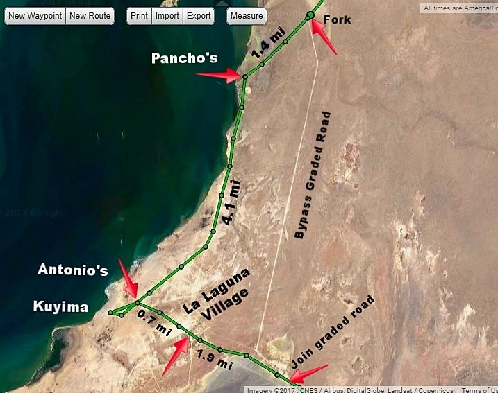
34.7 Bypass road south, avoids whale camps and village. Signed San José de Garcia. Log goes on right branch, to the lagoon.
36.1 Pancho’s whale camp entrance, on right.
36.2 Lagoon shore.
38.8 Fork, keep right. Left goes into village.
40.2 Crossroad. Antonio’s Camp is to the right, Kuyima Camp is 0.4 mi ahead. Turn left (east) to continue south. Operations open during whale
watching season. Typically, that is December-April.
40.9 La Laguna village, pass through to far side. Several optional roads come back together.
42.8 Join graded bypass road from Mile 34.7, above.
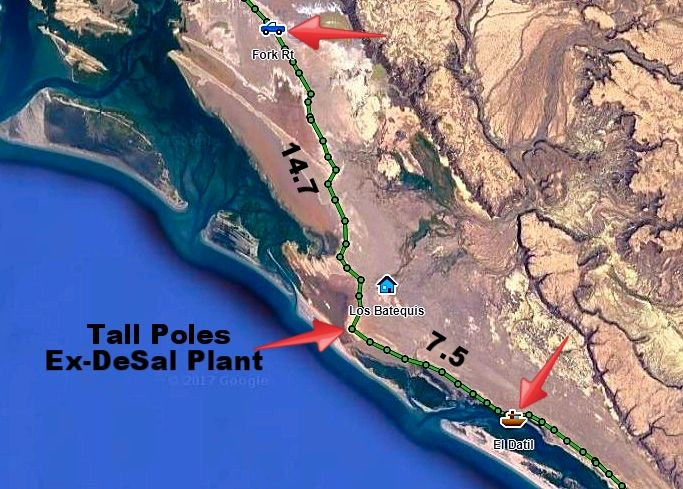
46.7/ 0.0 Major Fork. Small sign “Salina” here. The left branch is the high road via Rancho Cuarenta and the access to San José de Garcia. The
low road returns to the high road after 39 miles. This road log uses the more popular low road, longer but smoother driving, if dry. Reset odometer to
zero.
The washboard surface begins very bad but soon improves. Deflating tires by ~30% improves the ride and traction off the pavement.
14.7 Abandoned building and many high poles now serving as osprey nests mark a former desalinization project. The road soon reaches the salt flats. It
is advised to avoid any shortcuts across the flats and stay on the route that follows the desert’s edge.
22.2 El Dátil fishing village. Limited supplies.
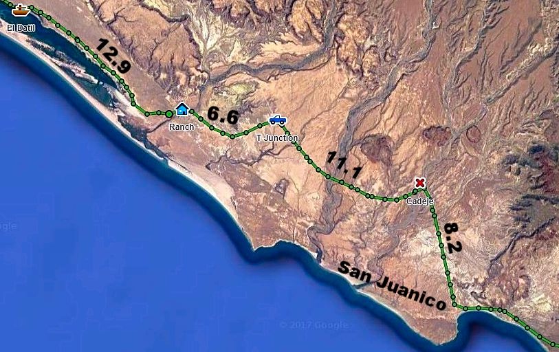
32.0 Sand dunes near the south end of salt flats. The road begins to turn inland.
35.1 Rancho El Datilón. The road soon turns south and crosses an arroyo.
41.7 Junction with high road coming approx. 39 miles from the fork at Mile 0.0, above. Turn south for San Juanico and on to La Paz.
46.7 Rancho La Ballena at Arroyo San Raymundo. The mountain road from Mulegé came in here, but recent storms may have altered the route.
52.8 Cadeje an oasis village with an airstrip.
61.0 San Juanico town entrance. Motels, restaurants, supplies. Popularly known as Scorpion Bay by surfers. Paved road south to Las Barrancas and on to
Ciudad Insurgentes and Highway 1 to La Paz or Loreto.
[Edited on 9-1-2017 by David K]
|
|
|
TMW
Select Nomad
Posts: 10659
Registered: 9-1-2003
Location: Bakersfield, CA
Member Is Offline
|
|
Excellent David, thanks.
|
|
|
TMW
Select Nomad
Posts: 10659
Registered: 9-1-2003
Location: Bakersfield, CA
Member Is Offline
|
|
FYI note on the San Raymundo road at Rancho La Ballena. The sign at the north end says it is 80 KM or 50 miles. I've driven it several times and it is
about 38 miles.
|
|
|
David K
Honored Nomad
Posts: 64479
Registered: 8-30-2002
Location: San Diego County
Member Is Offline
Mood: Have Baja Fever
|
|
Quote: Originally posted by TMW  | | FYI note on the San Raymundo road at Rancho La Ballena. The sign at the north end says it is 80 KM or 50 miles. I've driven it several times and it is
about 38 miles. |
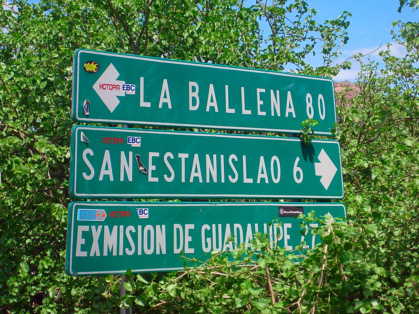
Here that sign is. 80 kms = 49.6 miles. The AAA map shows it as 40.5 miles.
Your 38 miles agree with AAA more.
I did not even notice that road joining in by La Ballena. There was no sign, either. Just one for La Ballena. I thought I read here that it was
detoured over to come out at Cadeje?
The Ex-Mision of Guadalupe was also only 25 kms. from this sign, not 27... (15.5 miles).
[Edited on 9-1-2017 by David K]
|
|
|
David K
Honored Nomad
Posts: 64479
Registered: 8-30-2002
Location: San Diego County
Member Is Offline
Mood: Have Baja Fever
|
|
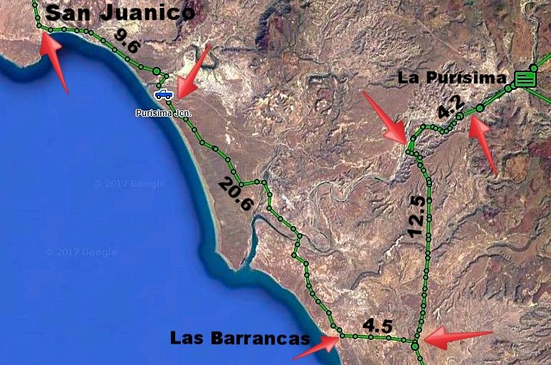
Map added San Juanico to Las Barrancas showing new highway route.
|
|
|
|


