| Pages:
1
2
3 |
mtgoat666
Select Nomad

Posts: 17295
Registered: 9-16-2006
Location: San Diego
Member Is Offline
Mood: Hot n spicy
|
|
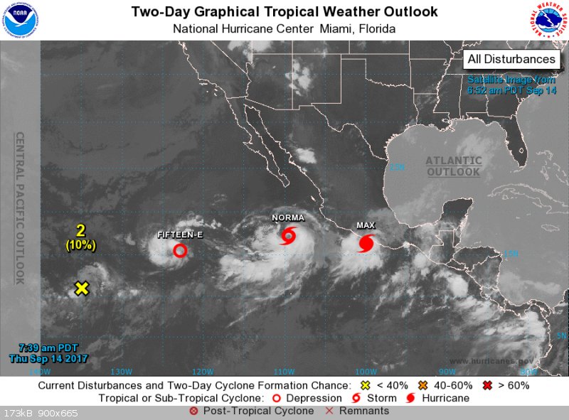
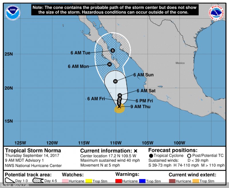
Hurricane Norma

Tropical Storm Norma Discussion Number 1
NWS National Hurricane Center Miami FL EP172017
900 AM MDT Thu Sep 14 2017
The convective structure of the area of disturbed weather well to
the south of the Baja California peninsula has continued to
increase in organization, with an elongated band wrapping around
the southern and eastern sides of the circulation. Dvorak intensity
estimates have increased to T3.0/45 kt from TAFB and T2.0/30 kt
from SAB, so the system is now classified as a 35-kt tropical storm.
Since Norma has just recently consolidated, its motion is a little
uncertain, but the best estimate is slowly northward, or 360/4 kt.
Norma is located to the northwest of a mid-level ridge that extends
westward from Central America, but it is also due south of a
blocking high centered over northwestern Mexico. As a result, the
storm is expected to only drift slowly northward for the next 48
hours or so. After 48 hours, a more pronounced northward motion is
forecast, but there is a lot of spread among the track models
regarding exactly how fast Norma moves north and if it moves east or
west at all. On the eastern side of the guidance envelope, the GFS
has a weaker ridge over Mexico and a deeper trough off the
California coast, which would cause Norma to turn northeastward
near the southern part of the Baja California peninsula. On the
western side of the guidance, the ECMWF maintains a stronger ridge,
forcing Norma to turn northwestward to the west of the Baja
California peninsula. Until the evolving pattern becomes clearer,
the NHC track forecast is between these two extremes and lies
closest to the HFIP Corrected Consensus Approach (HCCA).
Norma is over very warm waters and should remain in a low-shear
environment for at least the next 48-72 hours. As a result,
steady strengthening is anticipated, and Norma could reach
hurricane strength within about 36 hours. Strengthening should
continue through 48-72 hours until vertical shear begins to
increase, and a weakening trend is likely to occur on days 4 and 5.
The NHC intensity forecast closely follows the SHIPS guidance and
the ICON intensity consensus, and it is slightly below the HCCA
output.
[Edited on 9-14-2017 by mtgoat666]
[Edited on 9-14-2017 by BajaNomad]
Woke!
“...ask not what your country can do for you – ask what you can do for your country.” “My fellow citizens of the world: ask not what America
will do for you, but what together we can do for the freedom of man.”
Prefered gender pronoun: the royal we
|
|
|
shari
Select Nomad
Posts: 13033
Registered: 3-10-2006
Location: bahia asuncion, baja sur
Member Is Offline
Mood: there is no reality except the one contained within us "Herman Hesse"
|
|
Ahhh...Norma...such a tease!
shall we start taking bets?
|
|
|
carlosg
Senior Nomad
Posts: 504
Registered: 5-28-2012
Location: chula vista, ca
Member Is Offline
Mood: Just like in Baja: No Bad Days...
|
|
...looks like a busy week.... http://www.nhc.noaa.gov/?epac
starting with "Norma"
[Edited on 9-14-2017 by carlosg]
|
|
|
StuckSucks
Super Nomad
Posts: 2306
Registered: 10-17-2013
Member Is Offline
|
|
Interesting. A friend who lives in San Felipe and is a weather-enthusiast x100 told 2+ weeks ago that me a storm was going to hit San Felipe on 9/18.
He wasn't far off.
|
|
|
Russ
Elite Nomad
Posts: 6741
Registered: 7-4-2004
Location: Punta Chivato
Member Is Offline
|
|
Good reports. Thanks
Bahia Concepcion where life starts...given a chance!
|
|
|
Howard
Super Nomad
Posts: 2346
Registered: 11-13-2007
Location: Loreto/Manhattan Beach/Kona
Member Is Offline
Mood: I'd rather regret the things I've done than regret the things I haven't done.
|
|
If your friend is that good, how about the winning lotto numbers?  ) )
We don't stop playing because we grow old;
we grow old because we stop playing
George Bernard Shaw
|
|
|
Russ
Elite Nomad
Posts: 6741
Registered: 7-4-2004
Location: Punta Chivato
Member Is Offline
|
|
Just came across this ... so don't be too pessimistic. Things change
Bahia Concepcion where life starts...given a chance!
|
|
|
vandenberg
Elite Nomad
Posts: 5118
Registered: 6-21-2005
Location: Nopolo
Member Is Offline
Mood: mellow
|
|
On Windy, the European forecast has Norma going into the Pacific, while the American forecast has it going across the peninsula towards the mainland.
Go figure.
|
|
|
AKgringo
Elite Nomad
Posts: 5807
Registered: 9-20-2014
Location: Anchorage, AK (no mas!)
Member Is Offline
Mood: Retireded
|
|
On the Windy.com site, the GFS model doesn't look good for Cabo! This is the projection for Sunday;
https://www.windy.com/?gfs,2017-09-17-19,26.077,-109.578,5,m...
The ECMWF model shows it far off to the southwest. Quite a spread of forecasts!
If you are not living on the edge, you are taking up too much space!
"Could do better if he tried!" Report card comments from most of my grade school teachers. Sadly, still true!
|
|
|
tiotomasbcs
Super Nomad
Posts: 1837
Registered: 7-30-2007
Location: El Pescadero
Member Is Offline
|
|
|
|
|
tiotomasbcs
Super Nomad
Posts: 1837
Registered: 7-30-2007
Location: El Pescadero
Member Is Offline
|
|
OOoops. OK, Shari. I'll bet ya we're gonna get wet down here on Sun/Monday! Norma is strengthening, Oh Boy.  Tio Tio
|
|
|
woody with a view
PITA Nomad
Posts: 15937
Registered: 11-8-2004
Location: Looking at the Coronado Islands
Member Is Offline
Mood: Everchangin'
|
|
Like I been saying:
http://www.stormsurfing.com/cgi/display.cgi?a=npac_height
Look out below!
|
|
|
BajaBill74
Nomad
Posts: 253
Registered: 1-27-2014
Member Is Offline
Mood: Beyond Extatic!
|
|
This is strange. I just went to indy.com and unlike AKgingo's link it shows it as West of Baja.
https://www.windy.com/?2017-09-17-18,23.504,-115.752,5
What I'm doing at work is so secret, even I don't know what I'm doing!
One should believe in God, because even Google doesn't know everything.
|
|
|
AKgringo
Elite Nomad
Posts: 5807
Registered: 9-20-2014
Location: Anchorage, AK (no mas!)
Member Is Offline
Mood: Retireded
|
|
Go down to the lower right corner of the screen and you can switch forecast models!
If you are not living on the edge, you are taking up too much space!
"Could do better if he tried!" Report card comments from most of my grade school teachers. Sadly, still true!
|
|
|
SFandH
Elite Nomad
Posts: 6925
Registered: 8-5-2011
Member Is Offline
|
|
Interesting. According to windy.com (or windyty, whatever):
"in comparison to GFS, the ECMWF model brings better resolution
as well as better accuracy of the forecast."
ECMWF is the model showing the storm to the west of Cabo.
GFS is a bullseye on Cabo, Sunday noon.
https://community.windy.com/topic/3286/windyty-implements-ec...
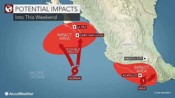
That's probably why "ACCUweather" is saying it's going to be here
or 200 miles over there. 
[Edited on 9-14-2017 by SFandH]
|
|
|
woody with a view
PITA Nomad
Posts: 15937
Registered: 11-8-2004
Location: Looking at the Coronado Islands
Member Is Offline
Mood: Everchangin'
|
|
Lidia part two!
|
|
|
mtgoat666
Select Nomad
Posts: 17295
Registered: 9-16-2006
Location: San Diego
Member Is Offline
Mood: Hot n spicy
|
|
Tropical Storm Norma Discussion Number 2
NWS National Hurricane Center Miami FL EP172017
300 PM MDT Thu Sep 14 2017
Norma has a broad and well-defined circulation with multiple
convective bands, especially to the east and south of the center.
Although the convective bands are a little broken in infrared
imagery, Dvorak intensity estimates have gone up to T3.5 from TAFB
and T2.5 from SAB and CIMSS at the University of Wisconsin. The
initial intensity has therefore been raised to 40 kt.
The cyclone continues to move slowly northward with an initial
motion of 010/5 kt. As mentioned in the previous discussion, a
blocking high to the north of Norma should impede its northward
motion for the next 48 hours, with the forward speed staying below
5 kt. There is still no clarity on the forecast track after 48
hours, with the new 12Z ECMWF and UKMET models remaining on the
western side of the guidance envelope to the west of the Baja
California peninsula, while the remainder of the models generally
show a track over the southern part of the peninsula then turning
into northwestern Mexico. Since the tracks of the GFS and HWRF
models lie close to the TVCN multi-model consensus and HCCA, the
NHC official forecast continues to favor this set of models.
Still, confidence in the forecast after 48 hours is quite low at
this time.
Since Norma already has a well-structured circulation, warm waters
and low shear should lead to a fairly fast increase in intensity
over the next couple of days. The updated NHC intensity forecast
is a little higher than the previous one and is generally close to
SHIPS and the ICON intensity consensus. An important note,
however, is that HCCA is higher than the NHC forecast, and the
rapid intensification indices, while not high, have increased from
6 hours ago. These trends will be watched, and it is possible that
Norma could strengthen more than shown here. Weakening is likely
to occur by days 4 and 5 due to land interaction with the Baja
California peninsula and increasing vertical shear.
Woke!
“...ask not what your country can do for you – ask what you can do for your country.” “My fellow citizens of the world: ask not what America
will do for you, but what together we can do for the freedom of man.”
Prefered gender pronoun: the royal we
|
|
|
mtgoat666
Select Nomad
Posts: 17295
Registered: 9-16-2006
Location: San Diego
Member Is Offline
Mood: Hot n spicy
|
|
yes, there are multiple models, and the layman don't know squat about choosing between them.
so i read the NWS forecast discussion, where they use non-machine educated judgement to interpret the models and choose the more accurate or probable
forecast.
Woke!
“...ask not what your country can do for you – ask what you can do for your country.” “My fellow citizens of the world: ask not what America
will do for you, but what together we can do for the freedom of man.”
Prefered gender pronoun: the royal we
|
|
|
shari
Select Nomad
Posts: 13033
Registered: 3-10-2006
Location: bahia asuncion, baja sur
Member Is Offline
Mood: there is no reality except the one contained within us "Herman Hesse"
|
|
and I bet you we dont! hahaha....I concur you will probably get wet and some wind and maybe swell too...typical mid September scenario eh.
Norma is in a seductive slow dance right now picking up energy and I predict will intensify rapido as she gets closer to the tip...I'd say she will
start to do the twist on Saturday and will have everyone clamoring to prepare again for round 2 on Sunday.
I seem to recall another Norma a few years back that was a rather nasty girl too.
|
|
|
motoged
Elite Nomad
Posts: 6481
Registered: 7-31-2006
Location: Kamloops, BC
Member Is Offline
Mood: Gettin' Better
|
|
Yes....switching forecast models:
https://www.youtube.com/watch?v=HSv3xcJCpNI
Don't believe everything you think....
|
|
|
| Pages:
1
2
3 |


