| Pages:
1
2 |
English bob
Newbie
Posts: 8
Registered: 9-15-2017
Member Is Offline
|
|
Tecate to Cabo
Thanks for having me.
Wife and I are leaving San Diego area early November to drive to Cabo San Lucas.
Done highway 1 so this time thinking the slow dirt road scenes route.
Slightly lifted 4x4 so shouldn't be clearance issues.
Is it worth the 'detour' to go San Felipe,Bahia De LA?
Thanks
|
|
|
David K
Honored Nomad

Posts: 64479
Registered: 8-30-2002
Location: San Diego County
Member Is Offline
Mood: Have Baja Fever
|
|
Not sure what you are seeking. Is the 23 mile unpaved south end of Hwy. 5 the question or are you seeking an unpaved scenic route south instead of
Hwy.1?
See my 6 trip reports for 2017, as I covered many options.
I will happily suggest routes for you depending what you want to do.
|
|
|
English bob
Newbie
Posts: 8
Registered: 9-15-2017
Member Is Offline
|
|
I just want to see some beaches,sights and take our time driving there.
It will be a once in a lifetime drive for us so want to see anything that's worth a visit.
Dirt roads don't bother me because driving slowly isn't an issue but hotels are....my wife doesn't camp.
[Edited on 9-26-2017 by English bob]
|
|
|
Meany
Nomad
Posts: 453
Registered: 2-14-2009
Location: santa paula,calif
Member Is Offline
|
|
English Bob welcome. Yes go the 5 see the beaches. skip the farming towns. You will Love Baja. It's a Great place to see. November is a good
time to go. EnJoy.
|
|
|
David K
Honored Nomad
Posts: 64479
Registered: 8-30-2002
Location: San Diego County
Member Is Offline
Mood: Have Baja Fever
|
|
Ok, well you are in luck. L.A. Bay has several hotels, well more like motels.
Here are places with rooms for the first half:
1) San Felipe
2) Gonzaga Bay
3) L.A. Bay
Dirt road south.
4) Pta. San Francisquito
You get on Hwy 1 near Vizcaino and it's paved road to Asuncion.
5) Bahia Asunción
Coast road is dirt to Abreojos then paved to San Ignacio.
6) San Ignacio
See the Trip Reports forum here for details in my 2017 trip reports...
Trip 3: Mexicali to San Felipe. http://forums.bajanomad.com/viewthread.php?tid=85989
Trip 1: San Felipe to San Francisquito. http://forums.bajanomad.com/viewthread.php?tid=85374
Trip 5: San Francisquito to San Ignacio. http://forums.bajanomad.com/viewthread.php?tid=86781
Trip 2: San Ignacio to Loreto. http://forums.bajanomad.com/viewthread.php?tid=85756
Trip 6: Loreto to Cabo. http://forums.bajanomad.com/viewthread.php?tid=87323
[Edited on 9-26-2017 by David K]
|
|
|
Maderita
Senior Nomad
Posts: 634
Registered: 12-14-2008
Location: San Diego
Member Is Offline
|
|
Since you plan to enter at Tecate, there are several route options from there. You can drive east toward Mexicali (the 8 miles of highway east of La
Rumorsa is scenic), followed by 100+ miles of boring desert driving to San Felipe. Or, you could drive south from Tecate to Ensenada on Hwy 3 and
enjoy the wine country of Valle de Guadalupe. At Ensenada, choose Hwy 1 south, or drive Hwy 3 southeast toward San Felipe.
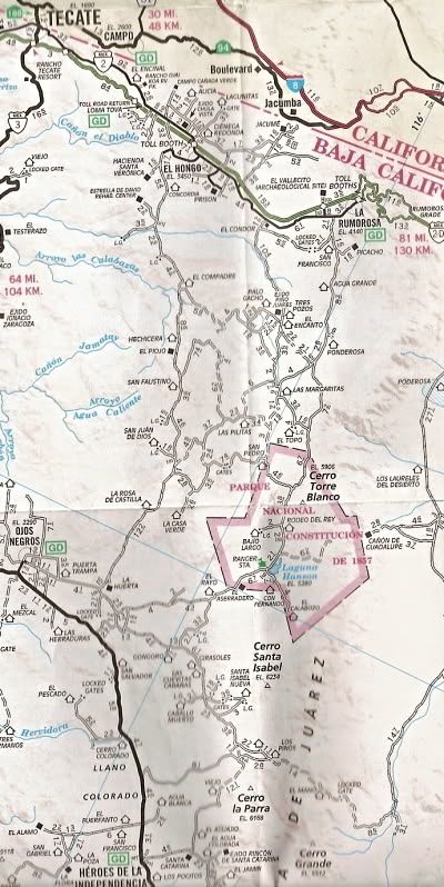
A much better alternative for scenic dirt roads is to drive through the pine-forested Sierra de Juarez: Drive east on Hwy 2 from Tecate (recommend the
"cuota" toll road for safer traffic) approx. 35 miles to La Rumorosa. Exit at "Vallecitos/ La Rumorosa" KM68 marker. Drive south 1/2 mile to the free
"libre" road and turn left (east). Top off the tank at the Pemex station, about 3/4 mile on the left. Maybe breakfast at Cabana del Abuelo next door,
good food with tortillas made while you watch.
Backtrack west about 1/4 mile and turn south on the road for the Parque Nacional/Laguna Hanson. Pavement ends in a mile. At mile 18, you will see the
300' granite domes at the headwaters of Canyon el Tajo.
Side trip: A few yards beyond the KM35 sign is a turnoff for Rancho El Topo. 2 miles to the ranch. If it's a weekend, there will be people there;
weekdays most of the time. The Sandoval family welcomes visitors. Horseback riding available. They have a guest cabana for rent, should you want to
overnight.
(I can help you contact for reservations).
Back on the Parque Nacional/Laguna Hanson road at KM35, continue south about 14 miles to the lake. Scenic lunch spot. Unless it rains, the lake may
not be more than a puddle by November. Continue south from the lake to the highway near Ojos Negros (maybe 25 miles?). Turn east for San Felipe or
west for Ensenada/Hwy 1.
This route is 2WD except after winter storms. Figure on 3 to 3.5 hours actual driving time on dirt roads from La Rumorosa to Ojos Negros (highway to
highway).
|
|
|
David K
Honored Nomad
Posts: 64479
Registered: 8-30-2002
Location: San Diego County
Member Is Offline
Mood: Have Baja Fever
|
|
Excellent information from Maderita!
English bob, Please let us know if you need anything more such as maps, etc. to have a fun and enjoyable trip south!
|
|
|
TMW
Select Nomad
Posts: 10659
Registered: 9-1-2003
Location: Bakersfield, CA
Member Is Offline
|
|
Unless Bob is familiar with the route from La Rumorosa thru the pine forest to Laguna Hanson and out to Hwy 3 it can be very confusing on where to
go.
I would suggest going by way of Santa Veronica and down to Ojo Negros or from the Indian Village out to Hwy 3.
|
|
|
David K
Honored Nomad
Posts: 64479
Registered: 8-30-2002
Location: San Diego County
Member Is Offline
Mood: Have Baja Fever
|
|
Quote: Originally posted by TMW  | Unless Bob is familiar with the route from La Rumorosa thru the pine forest to Laguna Hanson and out to Hwy 3 it can be very confusing on where to
go.
I would suggest going by way of Santa Veronica and down to Ojo Negros or from the Indian Village out to Hwy 3. |
It sounded like it was a dirt highway now, with kilometer markings, from Maderita's post?
I am going to check this area out soon, so I want to know what is the popular or main route between Hwy. 2 and 3 via Laguna Hanson, for four wheel
vehicles, not motorcycles.
|
|
|
TMW
Select Nomad
Posts: 10659
Registered: 9-1-2003
Location: Bakersfield, CA
Member Is Offline
|
|
English Bob do you have a GPS?
|
|
|
Maderita
Senior Nomad
Posts: 634
Registered: 12-14-2008
Location: San Diego
Member Is Offline
|
|
David,
Yes, you are way overdue on exploring the high country in the Sierra de Juarez. Glad to hear that you will be checking it out.
Not sure why TMW threw shade on the well-traveled route I suggested. It is graded seasonally. Recent years have brought many "improvements", incl. KM
markers, several road signs, and a few culverts installed to prevent washouts. Concrete was poured to improve the single difficult (100m of almost 4x4
in rainy months) section at approx. K38.
Driving south from La Rumorosa, the main route is shown on your map (above) as the eastern-most through road to Laguna Hanson.
Hit me up for more details or interesting side trips in the area...
|
|
|
English bob
Newbie
Posts: 8
Registered: 9-15-2017
Member Is Offline
|
|
Yes I do
|
|
|
David K
Honored Nomad
Posts: 64479
Registered: 8-30-2002
Location: San Diego County
Member Is Offline
Mood: Have Baja Fever
|
|
| Quote: Originally posted by Maderita | David,
Yes, you are way overdue on exploring the high country in the Sierra de Juarez. Glad to hear that you will be checking it out.
Not sure why TMW threw shade on the well-traveled route I suggested. It is graded seasonally. Recent years have brought many "improvements", incl. KM
markers, several road signs, and a few culverts installed to prevent washouts. Concrete was poured to improve the single difficult (100m of almost 4x4
in rainy months) section at approx. K38.
Driving south from La Rumorosa, the main route is shown on your map (above) as the eastern-most through road to Laguna Hanson.
Hit me up for more details or interesting side trips in the area... |
Thanks, I will!
|
|
|
TMW
Select Nomad
Posts: 10659
Registered: 9-1-2003
Location: Bakersfield, CA
Member Is Offline
|
|
| Quote: Originally posted by Maderita | David,
Yes, you are way overdue on exploring the high country in the Sierra de Juarez. Glad to hear that you will be checking it out.
Not sure why TMW threw shade on the well-traveled route I suggested. It is graded seasonally. Recent years have brought many "improvements", incl. KM
markers, several road signs, and a few culverts installed to prevent washouts. Concrete was poured to improve the single difficult (100m of almost 4x4
in rainy months) section at approx. K38.
Driving south from La Rumorosa, the main route is shown on your map (above) as the eastern-most through road to Laguna Hanson.
Hit me up for more details or interesting side trips in the area... |
I think for a first timer thru that area it can get confusing. After Laguna Hanson he would need to travel back west to Ojos Negros then on Hwy 3 back
east to Hwy 5. I doubt he could find the turn off to Hwy 3 at KM 55. I don't think it's marked as such.
If he has a GPS then he could follow way points to get him where he needs to go and to assure him where he is at on a map.
It is beautiful country with many places to see.
|
|
|
BajaBlanca
Select Nomad
Posts: 13165
Registered: 10-28-2008
Location: La Bocana, BCS
Member Is Offline
|
|
Bob, if you are really English then head over to La Bocana in Baja Sur and visit us. My husband lived in England and Wales for many years although
originally he is from Poland! His kids were born in Somerset.
He makes a mean breakfast (included at our B&B) and this is going to be his last year doing it so come and enjoy while you can!
Have fun on your trip and welcome to bajanomad. Your wife will like this side by the Pacific too.
|
|
|
English bob
Newbie
Posts: 8
Registered: 9-15-2017
Member Is Offline
|
|
Thanks for the suggestions but now it seems my wife doesn't feel as adventurous as me.
Plan now is Tecate to Ensenada to San Felipe to Bahia de LA.
South from there is still in the planning stages.
Can anyone recommend hotels in or near San Felipe and Bahia de LA?
|
|
|
David K
Honored Nomad
Posts: 64479
Registered: 8-30-2002
Location: San Diego County
Member Is Offline
Mood: Have Baja Fever
|
|
Unless you want city congestion, avoid going through Ensenada if your destination is San Felipe (unless you are wine lovers).
Take Hwy. 2 &2-D east to Hwy. 5, then south to San Felipe. North side of town is the Blu Sky Inn, recommended for a highway side motel. If you
want a beach side resort hotel, then the El Cortez is popular.
L.A. Bay has many motels and a couple hotels. The Los Vientos hotel is north from the traffic circle and under new management. In town is past traffic
circle is Costa del Sol (do not order scallops here), Guillermos (on the beach), Villa Vita (has a pool), and Las Hamacas.
All are detailed and photographs of many in my Trip #1 report.
[Edited on 9-27-2017 by David K]
|
|
|
TMW
Select Nomad
Posts: 10659
Registered: 9-1-2003
Location: Bakersfield, CA
Member Is Offline
|
|
Several hotels to choose from in LA Bay. Costa del Sol is popular, good food and clean rooms, on the right side about mid-way thru town. I like
Guillermo's near the end of the main drag on the left. Good food good rooms and a dining area near the water.
For other facilities: http://www.bahiadelosangeles.info/accomodations.htm
By the way if you are taking the dirt road south out of LA Bay you'll come to Pancho's place at about 45 miles. Nice guy living on the water. Likes a
cold beer if you have any. I usually take him rice and pinto beans and maybe a carton of soup. The packaged kind like ramen 24 to a carton.
Same for Coco, you must stop at Cocos south of Gonzaga Bay, just to say hello if nothing else. A guy with no legs living in the middle of no where.
Coco sells beer.
[Edited on 9-27-2017 by TMW]
|
|
|
English bob
Newbie
Posts: 8
Registered: 9-15-2017
Member Is Offline
|
|
Do you recommend pre booking at any of the stops?
|
|
|
bajaric
Senior Nomad
Posts: 602
Registered: 2-2-2015
Member Is Offline
|
|
In my experience outside of holiday periods pre booking is not needed at most of the lodging in the places you wish to visit, as they are usually
half empty. The exception is when sometimes a groups will reserve an entire facility, such as for an off-road event. It would not hurt to contact
them via email to ensure a room will be available.
Southbound, I would stay on one side or the other. You can cross the easy border at Mexicali and head south and enjoy the long stretches of scenic
desert bordered on the one side by the Sea of Cortez, or cross at Tijuana and make your way southward among the farm town traffic and enjoy views of
the majestic Pacific Ocean. Northbound is the time for taking the route from Ensenada to Tecate, due to the easier crossing and by then you will be a
Baja veteran.
|
|
|
| Pages:
1
2 |


