| Pages:
1
2 |
PaulW
Ultra Nomad

Posts: 3004
Registered: 5-21-2013
Member Is Offline
|
|
InReach straight lines
I finally took some time to figure out some things
How to View an InReach track (no more straight lines)
I go on a trip and send an email to myself or anybody else with trip details.
What arrives in the email is a link to all my trips
1-Go to the sidebar and click on “map filters” and choose “most recent track”
(Of course you can go back to the oldest trips and se several Baja trips)
2-Go to Message type and disable all the options except “Track points”
3-Click on “center”
4-And start zooming and panning to see my track You should choose Tops for best results , but you have other choices to play with. Just click on the
arrow and choose one you like.
5- of course at any time you can make a screen shot to share with others.
Here is my latest link for you to play with.
<https://share.garmin.com/PaulWilson>
And below is a screen shot of part of the latest trip

Now with that task done I go to explore.delorme.com/map and get redirected to inreach.garmin.com/map. Now I have a screen that is similar to the
viewing screen above with a lot more choices. Enter your inReach user and password for required. Follow steps 1 and 2 above then click on "Export"
then make a KML Google earth and a GPX GPS file
[Edited on 10-8-2017 by PaulW]
|
|
|
David K
Honored Nomad
Posts: 64476
Registered: 8-30-2002
Location: San Diego County
Member Is Offline
Mood: Have Baja Fever
|
|
OK Paul,
I am trying to duplicate your instructions... I turned on the inReach and sent myself an email with a standard message.
When I open the email and click on the link, there is the full page map with my location showing.
There is no sidebar, only the options to change the map to aerial or street, etc. and to send (me) a message. No other link or clickable item such as
one to expand a side menu (as there is on the homepage Explore "inreach.garmin.com" map link).
Going right to the inReach Explore homepage does not need me to email myself, and there are the features there you describe... I still get many
straight lines in places bypassing or flying over the driving track points.
The other curiosity is that some tracks have only track points every 10 minutes and other tracks have them at 1-minute spacings, yet I never changed
the setting? My inReach is set to 1-minute locations and uplink every 10 minutes, so those following my progress can see where I am within 10 minutes.
Thank you for your research on this and any help for this old guy is appreciated!
|
|
|
ehall
Super Nomad
Posts: 1906
Registered: 3-29-2014
Location: Buckeye, Az
Member Is Offline
Mood: It's 5 o'clock somewhere
|
|
Dk. Did you hit the share button on inreach?
|
|
|
David K
Honored Nomad
Posts: 64476
Registered: 8-30-2002
Location: San Diego County
Member Is Offline
Mood: Have Baja Fever
|
|
Share button? That is under Tracking. Paul did not say Live Tracking but did say to click most recent track. Do things change on the 'email map' when
tracking live is on? I was only trying to follow Paul's instructions, to the tee.
I click 'Messages' to send an email from the inReach.
As I said, I get the email link to my map... there just is no menu bar on that map... as Paul mentions, as there is on the Explore homepage for out
Delorme devices.
Thank you!!!
|
|
|
4x4abc
Ultra Nomad
Posts: 4163
Registered: 4-24-2009
Location: La Paz, BCS
Member Is Offline
Mood: happy - always
|
|
works for me using your older tracks, David.
Yu have to specify the time range
Harald Pietschmann
|
|
|
PaulW
Ultra Nomad
Posts: 3004
Registered: 5-21-2013
Member Is Offline
|
|
Use "share" in the InReach to get the link to the recipient. That is the only way to get the link. I send the thing to my self via email and use my
computer for all the stuff I described.
However, The owner of the Inreach can log on to the map link I noted and find the track and create a GPX or KML for anybody to use.
For sure while the track is being created then click on "Live Tracking" For example if you want to have someone see what you are doing real time the
use liver tracking. Mostly I use Inreach like David does and make tracks or pictures when I get home.
|
|
|
PaulW
Ultra Nomad
Posts: 3004
Registered: 5-21-2013
Member Is Offline
|
|
Quote: Originally posted by David K  | OK Paul,
I am trying to duplicate your instructions... I turned on the inReach and sent myself an email with a standard message.
When I open the email and click on the link, there is the full page map with my location showing.
There is no sidebar, only the options to change the map to aerial or street, etc. and to send (me) a message. No other link or clickable item such as
one to expand a side menu (as there is on the homepage Explore "inreach.garmin.com" map link).
Going right to the inReach Explore homepage does not need me to email myself, and there are the features there you describe... I still get many
straight lines in places bypassing or flying over the driving track points.
The other curiosity is that some tracks have only track points every 10 minutes and other tracks have them at 1-minute spacings, yet I never changed
the setting? My inReach is set to 1-minute locations and uplink every 10 minutes, so those following my progress can see where I am within 10 minutes.
Thank you for your research on this and any help for this old guy is appreciated! |
========= =========
I did not mention Share because it was in the link I included in the first post.
The settings you have for InReach are good, but do not relate to what the map has. What you want is the tracklog with is always there when you start
your track with your Inreach.
So what you do with your InReach is share and send the email to someone like your self. Any message works. I use the default starting my trip. Open
you email and here is what you get
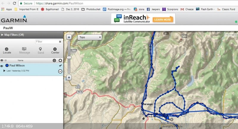
Next log into your map account and here is what you get
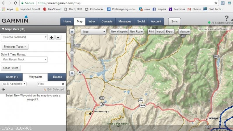
So unless I screwed up you can see what the screens look like.
Does it work for you?
[Edited on 10-9-2017 by PaulW]
|
|
|
PaulW
Ultra Nomad
Posts: 3004
Registered: 5-21-2013
Member Is Offline
|
|
PS
Once you use your Inreach to share a link to someones email you do not have to do it again, just save it. All your trips will be there when you open
your share link. Follow the instructions about "track points" and "date/time" then you can make screen shots to send people or post on the forum.
Next open you map account and click on "Export" to create KML and/or GPX files. As in the share link you still need to deal with "track points" and
"date/time"
It is getting pretty easy now.
|
|
|
David K
Honored Nomad
Posts: 64476
Registered: 8-30-2002
Location: San Diego County
Member Is Offline
Mood: Have Baja Fever
|
|
I see those straight lines on the first map of the post above with two maps on it.
Somehow there are steps missing so my results were different.
I will look more tomorrow, but I need to prepare for my next trip, too.
Thanks for doing all this and I am sorry I have a hard time following your steps. Please be patient with me.
|
|
|
PaulW
Ultra Nomad
Posts: 3004
Registered: 5-21-2013
Member Is Offline
|
|
I feel your pain. It took me a while to deal with it as well.
Do this to get rid of straight lines. On the sidebar from the share link
2-Go to Message type and disable all the options except “Track points”
If you do not have a share link with the side bar then create it again.
Track points are the breadcrumbs that the GPS is constantly creating when ever you have your InReach tracking turned on. Works like any GPS.
[Edited on 10-9-2017 by PaulW]
|
|
|
David K
Honored Nomad
Posts: 64476
Registered: 8-30-2002
Location: San Diego County
Member Is Offline
Mood: Have Baja Fever
|
|
| Quote: Originally posted by PaulW | I feel your pain. It took me a while to deal with it as well.
Do this to get rid of straight lines. On the sidebar from the share link
2-Go to Message type and disable all the options except “Track points”
If you do not have a share link with the side bar then create it again.
Track points are the breadcrumbs that the GPS is constantly creating when ever you have your InReach tracking turned on. Works like any GPS.
[Edited on 10-9-2017 by PaulW] |
OK, I turned my Tracking on, emailed that notification to myself, from the device, and I get the (share.garmin.com/****) link page.
I click my name (+ sign) and then turn on Map Filters (in order to see Message Types).
I unclick all the choices except Track Points.
I selected a date range (for my first 2017 trip in this case)'
... and I still have random straight lines overflying roads I drove connecting track points in addition to the actual road dring track points.
Turning on Tracking didn't alter a thing and I do get the same map and sidebar as the Explore site (inreach.garmin.com/Map).
Any more ideas? Thanks!
PS How about why some of my road tracks have lots of dots (1-minute points) and others are only 10-minute points apart? I never changed the settings
during the trip, and this is on the same trip.
|
|
|
PaulW
Ultra Nomad
Posts: 3004
Registered: 5-21-2013
Member Is Offline
|
|
Does not work for multiple trips. I still get a combination of straight lines and track points or just straight lines. When I do a specific recent
trip the all is well and all I get is track points. A good reason to choose the latest trip, and then save the images as you proceed to later trips.
I went back in time and isolated a trip from 2/10/17 and the track points are gone and I just get the straight lines. My conclusion is track points
have a life, but the straight lines live on.
Moral of the story is if you want to preserve a trip with track points the do it right after the trip. By choosing most recent, last 24 hours or last
7 days. , but if you want multiple trips in 7 days then you probably will get a bad result????
For trips like David does involving multiple days there are two approaches, such as not turn off the inreach or stop tracking. That way you would get
one large trip with track points. ?? I wonder if there is a limit on track points for such a long trip. On the other hand maybe a new trip for each
day would work better than a huge trip?? That would work for sure if you can use your computer to grab track points for each trip before the track
points disappear, and keep the image for the day on the computer until you get home. Trouble is Internet is required to grab the share link.
For sure David’s long trips will be a challenge and I hope he can give us a result.
I will keep researching to try to get some answers.
|
|
|
David K
Honored Nomad
Posts: 64476
Registered: 8-30-2002
Location: San Diego County
Member Is Offline
Mood: Have Baja Fever
|
|
Great!
I entered a date range just for one trip, as instructed... the first trip of this year... and it shows some straight lines in addition to the 1-minute
and 10-minute track points. Oh well... It still is fun to be able to communicate with friends and family while out in the boonies, plus have the gps
map.
The straight lines happened on the same day and not because tracking was turned off and back on... oh well... one of these days. I just like the
map-making and those over-fly lines mess up, as well as the 10-minute connecting lines. The 1-minute points are great, however.
|
|
|
4x4abc
Ultra Nomad
Posts: 4163
Registered: 4-24-2009
Location: La Paz, BCS
Member Is Offline
Mood: happy - always
|
|
as i posted many times before - inReach is a great tool. But only because it has no competitors.
It has so many flaws that I want to eat my shoes every time I use it.
And I had high hopes that once ownership would change to Garmin, that they would fix all the bugs.
Nope. Did not happen
Harald Pietschmann
|
|
|
jaymtb
Junior Nomad
Posts: 92
Registered: 3-30-2004
Member Is Offline
|
|
More Inreach
Good point re not much competition. They have fixed some things over time- try updating the Sync program and the firmware in unit. The newer
Weather function is useful with no data or radio available. It is still a bit crude.
Garmin takeover is a mixed blessing. They have the tech and capital to make it right. However, Garmin has for years used "crippleware" as a
business strategy. This means just updating a newer model enough to attract some sales with expanded features- versus putting in what is readily
available at an attractive cot.
|
|
|
David K
Honored Nomad
Posts: 64476
Registered: 8-30-2002
Location: San Diego County
Member Is Offline
Mood: Have Baja Fever
|
|
Paul, I see you did an edit and added maps and details to you 8:52 pm post... I will study that more when I get back from Baja in a week!
Thank you!
PS, as a note, the email 'message' map does not have a sidebar menu, for me... only the Share map when tracking or map on the Explore site (your
second image).
|
|
|
PaulW
Ultra Nomad
Posts: 3004
Registered: 5-21-2013
Member Is Offline
|
|
| Quote: Originally posted by David K | Paul, I see you did an edit and added maps and details to you 8:52 pm post... I will study that more when I get back from Baja in a week!
Thank you!
PS, as a note, the email 'message' map does not have a sidebar menu, for me... only the Share map when tracking or map on the Explore site (your
second image). |
======
look at my URL on the images
First image is from SHARE email and before I used the sidebar features
2nd image is from my account on the map pull down
Fix your settings - here are mine:
Need help with inReach setup?
https://www.youtube.com/watch?v=qe-Fm0FL4Hw
and
https://www.youtube.com/watch?v=0NdwB_OjzdM
InReach back to basics. My cheat sheet for always use with external power.
Remember to do Sync before every trip. See below
Settings:
Display: screen lock =off, brightness = 50%, timer = always on, always on w external power = on
Map: orientation = heading up all other features = on
Tracking: Send = 10 min, log = 1 min, extended = off, Prompt map share = on, auto tracking =on
(Note when inReach is stationary the send interval defaults to 4 hours until you start moving. I don’t trust that statement so I check my tracking
screen to make sure it is set at 10 min.)
Bluetooth enabled = off, pair inReach = I pair to my iPhone – repeat if necessary, Connected = no
Compass: don’t use
Messages: interval =5 min, ring = off
Trip Info:
Reset for each trip, and reset trip and all
Sync:
On your computer - Go to your inReach account (Map) and find the sync button If your InReach is turned on it will sync and give you updated etc. Go
back to your account (map) and hit sync and this time choose Launch. Connect your USB to the InReach and allow the up date and sync to be executed.
How about help with Earthmate
For your phone: https://www.youtube.com/watch?v=Z03qu6UXGGk
more on Earthmate later.
Fixed typos I hope
Have a good trip
[Edited on 10-10-2017 by PaulW]
[Edited on 10-10-2017 by PaulW]
|
|
|
PaulW
Ultra Nomad
Posts: 3004
Registered: 5-21-2013
Member Is Offline
|
|
Please re-read my last post for my edit
Thanks
|
|
|
PaulW
Ultra Nomad
Posts: 3004
Registered: 5-21-2013
Member Is Offline
|
|
| Quote: Originally posted by 4x4abc | as i posted many times before - inReach is a great tool. But only because it has no competitors.
It has so many flaws that I want to eat my shoes every time I use it.
And I had high hopes that once ownership would change to Garmin, that they would fix all the bugs.
Nope. Did not happen
|
========
Help is very slow in coming. Regular Google search to answer my questions have had marginal success. See the utube links in my post above. When you go
to the links I posted don't ignore the sidebar links for even more tutorials.
So instead of dealing with the cumbersome software they have invented new units with their own form factor. Price went up for added features with
dubious benefit. (+50)
The new units are Explorer+ and SE+
If you play with your inReach settings let me know what if I have it correct now.
In spite of all the issues I am sure getting nice GPS and KML files for my most recent trips.
|
|
|
carlosg
Senior Nomad
Posts: 504
Registered: 5-28-2012
Location: chula vista, ca
Member Is Offline
Mood: Just like in Baja: No Bad Days...
|
|
Any luck with getting rid of STRAIGHT LINES on inReach Explorer+...?
| Quote: Originally posted by David K | Great!
I entered a date range just for one trip, as instructed... the first trip of this year... and it shows some straight lines in addition to the 1-minute
and 10-minute track points. Oh well... It still is fun to be able to communicate with friends and family while out in the boonies, plus have the gps
map.
The straight lines happened on the same day and not because tracking was turned off and back on... oh well... one of these days. I just like the
map-making and those over-fly lines mess up, as well as the 10-minute connecting lines. The 1-minute points are great, however.
|
I followed Paul's instructions
http://forums.bajanomad.com/viewthread.php?tid=87914&got...
and
http://forums.bajanomad.com/viewthread.php?tid=87914&got...
But I still get the STRAIGHT LINES...
Any help is most welcome... will be leaving for Baja on tuesday...
|
|
|
| Pages:
1
2 |


