| Pages:
1
2 |
David K
Honored Nomad

Posts: 64476
Registered: 8-30-2002
Location: San Diego County
Member Is Offline
Mood: Have Baja Fever
|
|
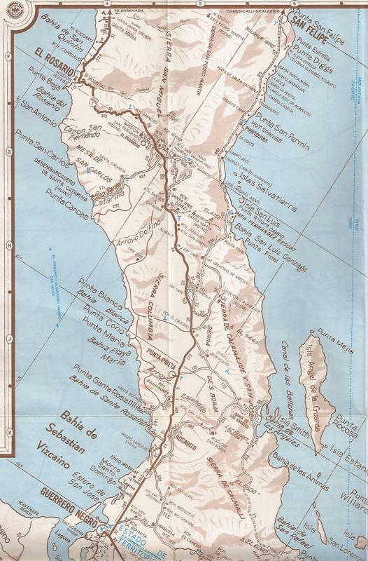
1974 Auto Club Baja Map
With the demise of Photobucket for free or inexpensive hosting of our maps and photos, this is a test to see how Postimage.org does with maps... A big
thank you to Barry A for sharing this map... Mine had been marked on and torn over the 43 years I had it!
This is posted for historic educational purposes and arranged from north to south, overall and close-ups:


1974 was the final year that the northern 1/4 Baja California was shown in such large detail (scale). The reverse side of the map had the smaller
scale remainder of the peninsula.
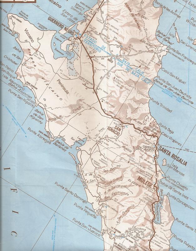
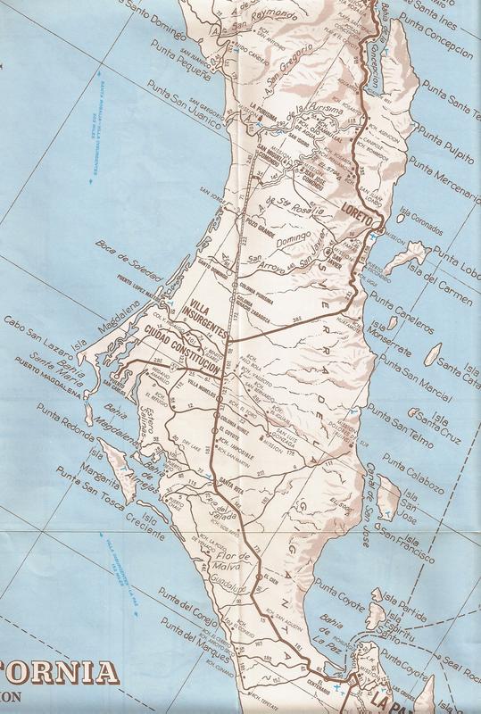
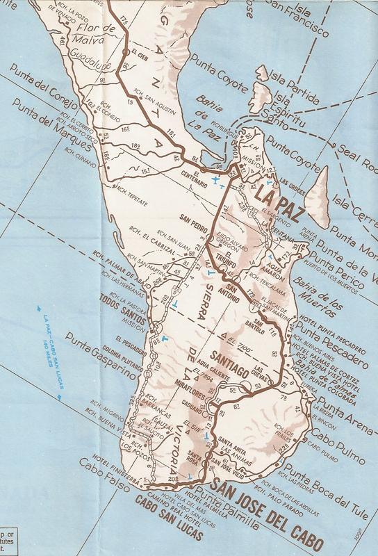
Some close-ups from that part:


-----------------------------------------------------
[Edited on 6-10-2018 by David K]
|
|
|
Barry A.
Select Nomad
Posts: 10007
Registered: 11-30-2003
Location: Redding, Northern CA
Member Is Offline
Mood: optimistic
|
|
Looks to me like it came thru just perfect, David. Good Job, and so glad that you and the folks are getting good use out of that map. It sure was
not doing much good sitting in my map cabinet. LOL
|
|
|
Udo
Elite Nomad
Posts: 6321
Registered: 4-26-2008
Location: Black Hills, SD/Ensenada/San Felipe
Member Is Offline
Mood: TEQUILA!
|
|
Looks like the area north of Ensenada, which is now known as the VALLE DE GUADALUPE, was originally known only as GUADALUPE.
To the locals, it is now known just as the VALLE.
Udo
Youth is wasted on the young!
|
|
|
David K
Honored Nomad
Posts: 64476
Registered: 8-30-2002
Location: San Diego County
Member Is Offline
Mood: Have Baja Fever
|
|
Quote: Originally posted by Udo  | Looks like the area north of Ensenada, which is now known as the VALLE DE GUADALUPE, was originally known only as GUADALUPE.
To the locals, it is now known just as the VALLE. |
Historically, the town was Guadalupe (named for the 1834-1840 mission there) and the colony of Russians (Rusos) from the time of the czars!
The Mexican government, in a PC move, renamed the town, Francisco Zarco. The locals coined the 'Valle de Guadalupe' brand to preserve the historic
name, I think?
|
|
|
David K
Honored Nomad
Posts: 64476
Registered: 8-30-2002
Location: San Diego County
Member Is Offline
Mood: Have Baja Fever
|
|
| Quote: Originally posted by Barry A. | | Looks to me like it came thru just perfect, David. Good Job, and so glad that you and the folks are getting good use out of that map. It sure was
not doing much good sitting in my map cabinet. LOL |
You know how much I appreciate your generosity, Barry. This was an April 1974 map, made just 5 months after Hwy. 1 was completed!
I am seeking the 1973 issue of the AAA map to see where the pavement and any new roadbed was shown. A 1972 issue would be as equally appreciated.
I do remember one of them, the '73 I think, that showed the paving part way to San Ignacio from Santa Rosalia, northbound. San Quintin or nearby,
southbound.
My first road guide was made in August 1973 from the family July trip down the new (and much of the old) roadbed...
My dad and I were following construction progress of Highway 1 closely and the rumors were indicating the final 300 miles of old road were a thing of
the past and paving was not far off (San Quintin-San Ignacio). Dad sold his 4WD Chevy Suburban and bought a Ford LTD Wagon with the 460 Lincoln
engine. He had adjustable air shocks installed and a second gas tank added to make this pre-Hwy. 1 Baja trip possible in an otherwise street-wagon.
I made close notes of the highway route, odometer readings, compass directions, etc. to document this brand new road that most knew very little about.
I had heard that El Arco was bypassed and the highway went closer to the newer town of Guerrero Negro after leaving San Ignacio.
This was (and still is) the kind of stuff that is great fun for me... I was 15 years old then!
In July 1973, we were a bit shocked when the paving ended so soon (at the Mission San Fernando junction, 40 miles beyond El Rosario). The new graded
roadbed we could drive ended near Rancho Sonora there was an access to Agua Dulce spring (for water trucks to fill for roadbed construction). From
there all the way to Laguna Chapala, it was the old main road we traveled by Jeep on in 1966! We did stop at Rancho Santa Ynez to see about staying in
the bunk rooms, but upon inspection, my mom would have none of that (very dusty)! We slept in the wagon somewhere south of Santa Ynez.
If anyone is wondering, there was no Cataviña, yet. That place (an old rancho site) would become a 'Parador' (gas station, rest stop, trailer park,
cafeteria, and Hotel El Presidente, and eventually a small town) after the highway was finished.
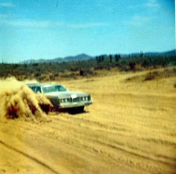
We drove in the famous (infamous) Chapala dust field alongside the new roadbed which had reached that point by July. My dad had me get out to take a
photo of his station wagon 'mastering' the Chapala dust!
A little further up, on the new roadbed:
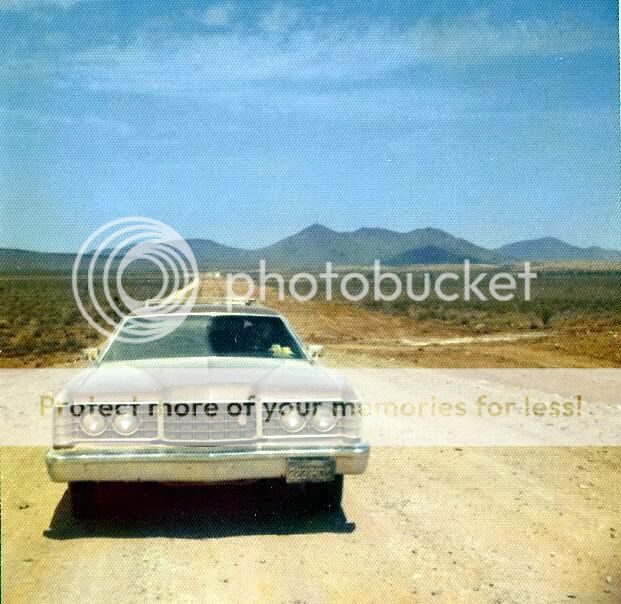
We encountered paving (but not yet driveable) somewhere north of Punta Prieta... the road to Bahía de los Angeles was not marked or we didn't see it.
There was nothing yet where the new paved L.A. junction would be.
Paving would end and begin again in sections as far south as around Jesus María (I recall), then all paved south. We stayed at the only motel there
was in Guerrero Negro in 1973, the Dunas... Loreto would be an easy drive from there the next day.
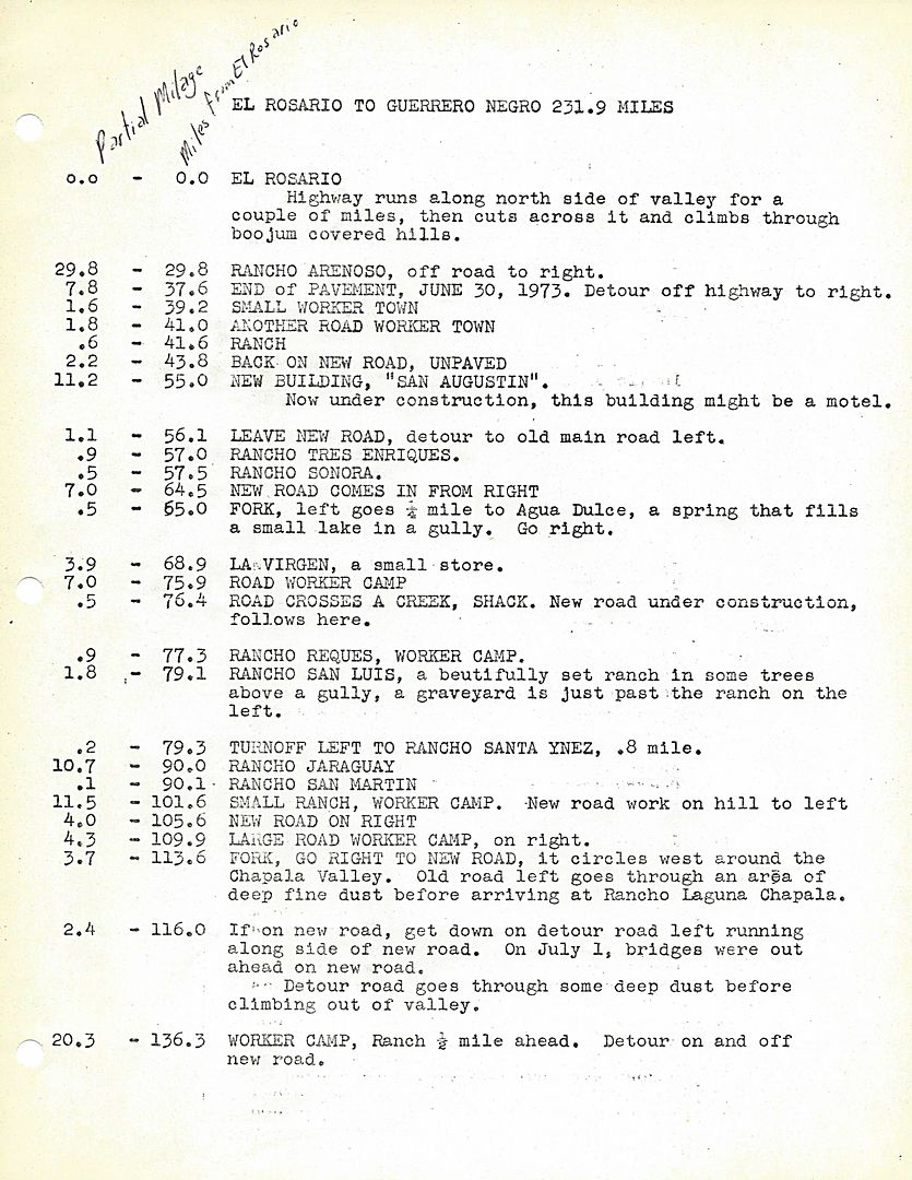
This is what I produced after the trip, very low budget, but I sold every one I made, at a couple of bookstores in Escondido (near where I lived,
then). It even got onto a morning TV show in San Diego (Ch. 8's Sun up):
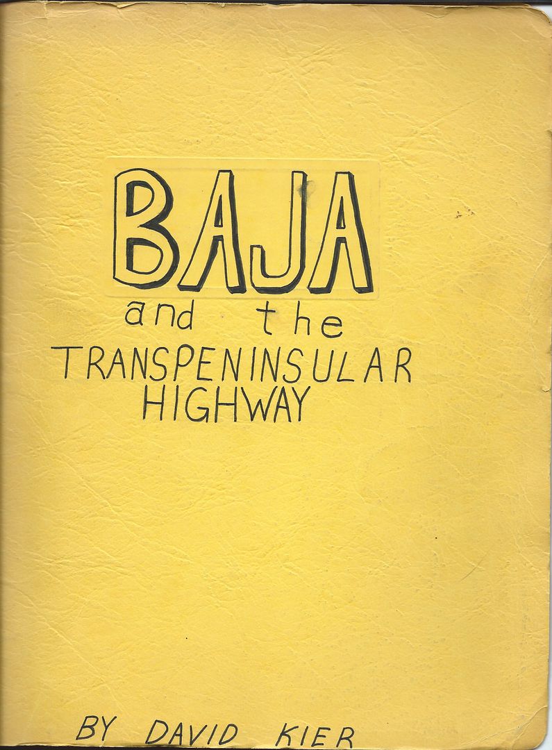
Some samples of inside:
Hey, even at 15, Baja was my 'drug of choice' 
[Edited on 11-7-2017 by David K]
|
|
|
Udo
Elite Nomad
Posts: 6321
Registered: 4-26-2008
Location: Black Hills, SD/Ensenada/San Felipe
Member Is Offline
Mood: TEQUILA!
|
|
Wow...what a historian, as well as a cartographer!
Udo
Youth is wasted on the young!
|
|
|
PaulW
Ultra Nomad
Posts: 3004
Registered: 5-21-2013
Member Is Offline
|
|
For Postimage what image size do you recommend?
|
|
|
David K
Honored Nomad
Posts: 64476
Registered: 8-30-2002
Location: San Diego County
Member Is Offline
Mood: Have Baja Fever
|
|
The above are at the Nomad max of 800 pixels. I believe that level is called '15" Monitor', but the Forum choice (640) is big, too, just not full
Nomad size, which I like for maps.
|
|
|
AlanDavid90
Junior Nomad
Posts: 27
Registered: 11-12-2017
Member Is Offline
|
|
First time on this forum, Is Stunning this Map of Baja California from 1974
|
|
|
David K
Honored Nomad
Posts: 64476
Registered: 8-30-2002
Location: San Diego County
Member Is Offline
Mood: Have Baja Fever
|
|
Welcome to Baja Nomad! There is a ton of maps from the past posted here the past 15 years. Please feel free to request any special area or zoom in
images.
|
|
|
AlanDavid90
Junior Nomad
Posts: 27
Registered: 11-12-2017
Member Is Offline
|
|
Thanks David
|
|
|
BajaTed
Senior Nomad
Posts: 859
Registered: 5-2-2010
Location: Bajamar
Member Is Offline
|
|
From the first picture of TJ and area, I remember the Bullring that is shown by the jct of the 1D and the M2, those were the days, hurraches,
bullwhips and BIG firecrackers
Es Todo Bueno
|
|
|
Barry A.
Select Nomad
Posts: 10007
Registered: 11-30-2003
Location: Redding, Northern CA
Member Is Offline
Mood: optimistic
|
|
| Quote: Originally posted by BajaTed | | From the first picture of TJ and area, I remember the Bullring that is shown by the jct of the 1D and the M2, those were the days, hurraches,
bullwhips and BIG firecrackers |
Yep---------really BIG firecrackers!!! Cherry-bombs, which were tiny bits of TNT, or sounded and acted like them!!! LOL
|
|
|
fishbuck
Banned
Posts: 5318
Registered: 8-31-2006
Member Is Offline
|
|
For some reason I find this map to be comforting and refreshing.
"A ship in harbor is safe, but that is not what ships are built for." J. A. Shedd.
A clever person solves a problem. A wise person avoids it. – Albert Einstein
"Life's a Beach... and then you Fly!" Fishbuck
|
|
|
David K
Honored Nomad
Posts: 64476
Registered: 8-30-2002
Location: San Diego County
Member Is Offline
Mood: Have Baja Fever
|
|
I am still hoping someone has the 1973 and/or 1972 AAA (Auto Club of Southern California) Baja Maps that can be shared here to compare to the April
1974 issue, above. Any of them from 1970-1973, in fact!
Thank you!
|
|
|
TMW
Select Nomad
Posts: 10659
Registered: 9-1-2003
Location: Bakersfield, CA
Member Is Offline
|
|
I have a 7-71 and a 9-73 version.
|
|
|
BigBearRider
Super Nomad
Posts: 1299
Registered: 4-30-2015
Location: Big Bear, Punta Chivato, and Cabo
Member Is Offline
Mood: 
|
|
I have the version that is mostly Orange and blue on the cover. I don't have it with me, and cannot recall what year it is, but I think it's later.
And, I think I've seen you post from it before, so I believe you have it.
|
|
|
JZ
Elite Nomad
Posts: 9215
Registered: 10-3-2003
Member Is Online
|
|
Interesting that the "Know before you go" is almost exactly the same 40 years later.
|
|
|
ligui
Senior Nomad
Posts: 825
Registered: 2-9-2008
Location: Fraser co.
Member Is Offline
Mood: love Baja !
|
|
Hi Guys ! good to jump in again . Dave K I've got some old maps ... Shelll map of Mexico and Baja Mexico 1960 and 1961 and some others .Would like to
dig thru files and send them to you ,and maybe you could look at them and see if you could get something out of them . Then send them back and i'm
going to frame them .
How about KYM's Guide No.6 Baja California Sea of Cortez 1968 ? Know that I have some AAA books / maps in there too
.
Let me know . Got Baja !
|
|
|
David K
Honored Nomad
Posts: 64476
Registered: 8-30-2002
Location: San Diego County
Member Is Offline
Mood: Have Baja Fever
|
|
Very cool... if you guys have the ability, please scan and share them or email the scans my way. Mailing them to me is another option and I can mail
them back if you want them back. TW, I sent you a u2u. That is great. I want to see how AAA showed pavement progress, most of which was between 1971
and the end of 1973. If my teenage memory from 1972/73 serves me right, the '73 map shows pavement north partially to San Ignacio from Santa Rosalia
and perhaps south to San Quintin. The '72 map shows south to Colonia Guerrero and north to Santa Rosalia...? So much was done in the single year of
1973 (San Quintin to San Ignacio)!!!
|
|
|
| Pages:
1
2 |


