| Pages:
1
2 |
PaulW
Ultra Nomad

Posts: 3004
Registered: 5-21-2013
Member Is Offline
|
|
Inreach track point viewing
Works for me
Inreach settings
Map: heading = up, All others = on
Tracking: Send = 10 min, Log interval = 30 Sec, extend = off, prompt = off, Auto track = On
Before trip plug in Inreach to PC
Sync
Unplug and turn on the Inreach and send message to your own email
Begin your trip, When done turn off Inreach
Connect Inreach to PC
Sync
When done with Sync choose” MAP”
On the left choose message filters. Message type. Only choose “track points” not others.
Date & time choose most recent. Or if you wait too long choose last 7 days.
WAIT
Result is track with dots and no stupid straight lines
== === == == =
The link you received via email will always have the straight lines which are the 10 minute WPs.
=== === =
To share the track with track points make a screen shot of the Map on your sync view on your Garmin account.
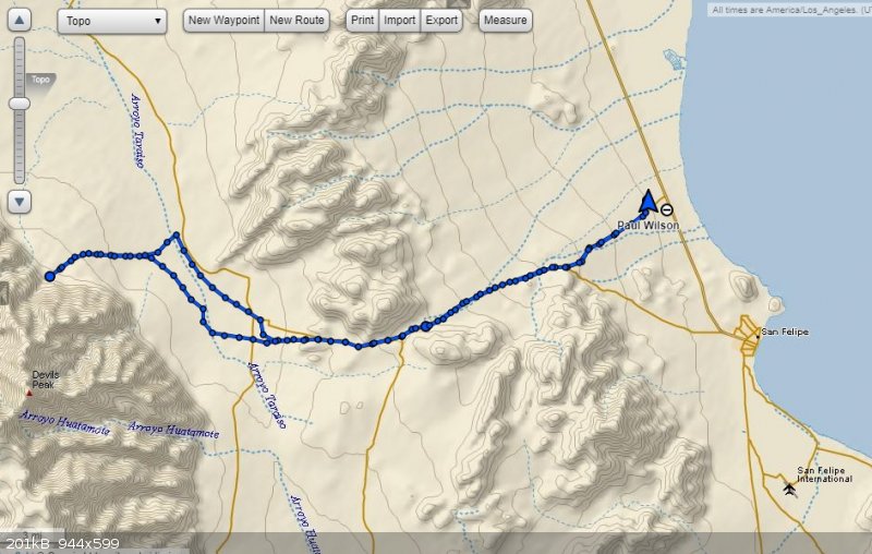
Here is todays trip from home to the entrance of canyon Dilabilito
|
|
|
rich t
Nomad
Posts: 102
Registered: 4-18-2016
Member Is Offline
|
|
Paul, How do you like using the inreach as a GPS vs stand alone GPS'S?
|
|
|
PaulW
Ultra Nomad
Posts: 3004
Registered: 5-21-2013
Member Is Offline
|
|
Not great because of lack of detail for the map.
I am using Lowrance for Baja and Inreach and ORUX for the US and
I find the Earthmate map which is required for Inreach to lack detail It is much better for the US compared to Lowrance.
ORUX allows nice big tablet like Earthmate) and has the ability to load custom maps. It holds great promise.
In any event the ability to send custom messages with Inreach will will trump all others. combined with a real GPS.
|
|
|
rich t
Nomad
Posts: 102
Registered: 4-18-2016
Member Is Offline
|
|
Thanks for the info, our Fire Dept. was thinking about getting the inreach and using it to replace our GPS's and I had heard the GPS aspect was not
very good, wanted to verify it from a real user.
|
|
|
BajaBlanca
Select Nomad
Posts: 13165
Registered: 10-28-2008
Location: La Bocana, BCS
Member Is Offline
|
|
That is a very neat looking mapped route.
|
|
|
David K
Honored Nomad
Posts: 64476
Registered: 8-30-2002
Location: San Diego County
Member Is Offline
Mood: Have Baja Fever
|
|
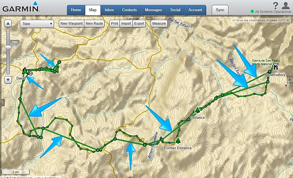
Paul, I did exactly what you listed... input the date range for a single day's travel, select Track Points with the others turned off...
Here is my track point (only) map for 24 hours starting October 14, 8:05 am: Camp near La Corona to the observatory to Meling to El Coyote towards
Mike's to by brake fail point, then back to El Coyote:
Still the straight, fly-over lines. Advise, please. They seem to connect the slightly larger circles?

|
|
|
PaulW
Ultra Nomad
Posts: 3004
Registered: 5-21-2013
Member Is Offline
|
|
Quote: Originally posted by David K  | Paul, I did exactly what you listed... input the date range for a single day's travel, select Track Points with the others turned off...
Here is my track point (only) map for 24 hours starting October 14, 8:05 am: Camp near La Corona to the observatory to Meling to El Coyote towards
Mike's to by brake fail point, then back to El Coyote:
Still the straight, fly-over lines. Advise, please. They seem to connect the slightly larger circles?
====== =======
Let me explain further
My new settings for future trips
Inreach settings, tracking:
choose send 10 minutes, and log 1 sec.
The result is more points.
You always get straight lines between points so more points mean less straight lines or invisible lines. Even tho the trip I posted had less points
than above it was good enough for my slow driving. New settings above will be even better. Fast driving means points are further apart and more
straight lines to connect the points.
You cannot go back to an older trip and create points, so you must do the Inreach setup before your trip then Sync. Then after the trip make the Map
settings (on your account) to agree with Inreach. I like to set my Map set up first then change my Inreach settings then Sync, then drive.
Keep your Inreach plugged in at all times because with the settings above you will have a short battery life.
If one was going hiking on battery then much fewer points and longer send would be appropriate.
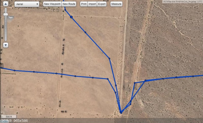
So here is a picture if I zoom way in on the trip to Dilabito. Note that straight lines are present and small dots are track points and big dots are
send dots.
 |
|
|
|
PaulW
Ultra Nomad
Posts: 3004
Registered: 5-21-2013
Member Is Offline
|
|
PS no micky mouse power from your stock vehicle. Power must be on always not just when your key is on. All my cars had to be rewired to provide direct
poser from the battery.
|
|
|
David K
Honored Nomad
Posts: 64476
Registered: 8-30-2002
Location: San Diego County
Member Is Offline
Mood: Have Baja Fever
|
|
You are not understanding me... Please look at the map I posted... I was driving on the road and not flying. The points along the road are fine, it is
the addition straight lines connecting random, further apart points... as if a drone was also recording and hopping ahead short-cutting. Look at the
map. See the road drive and then also see several straight lines in addition?
|
|
|
PaulW
Ultra Nomad
Posts: 3004
Registered: 5-21-2013
Member Is Offline
|
|
When you took the trip tell me your setup
Inreach settings, tracking:
send xx minutes, and log xx sec??
|
|
|
David K
Honored Nomad
Posts: 64476
Registered: 8-30-2002
Location: San Diego County
Member Is Offline
Mood: Have Baja Fever
|
|
| Quote: Originally posted by PaulW | When you took the trip tell me your setup
Inreach settings, tracking:
send xx minutes, and log xx sec?? |
Exactly the same, and it wasn't shut off.
I set the map above for the one day I went to the observatory.
My camp was near the new entrance, drove to the observatory, then back and on down to El Coyote and beyond then ended at El Coyote.
1-minute log interval, 10-minute send interval. Why the additional flyover straight lines is the mystery. They are random, too... connecting distant
points sometimes and 10 min. points others, and again, sometimes.
Blue arrows pointing to some of the straight track lines that I did not travel on:
[Edited on 11-9-2017 by David K]
|
|
|
PaulW
Ultra Nomad
Posts: 3004
Registered: 5-21-2013
Member Is Offline
|
|
The only thing I can think of is did you sync before and after the trip?
The instructions I found said it is required.
|
|
|
David K
Honored Nomad
Posts: 64476
Registered: 8-30-2002
Location: San Diego County
Member Is Offline
Mood: Have Baja Fever
|
|
| Quote: Originally posted by PaulW | The only thing I can think of is did you sync before and after the trip?
The instructions I found said it is required. |
I sync before and after each trip (and many other times as well). How would not syncing add these straight lines, anyway?
|
|
|
PaulW
Ultra Nomad
Posts: 3004
Registered: 5-21-2013
Member Is Offline
|
|
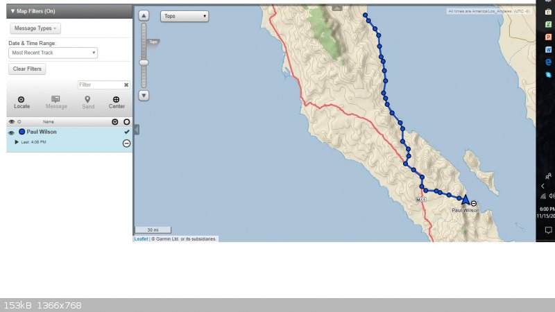
Today trip
Recent trip - today. No stupid straight lines. Just lines connecting the track points. No difference when I zoom way in.
|
|
|
David K
Honored Nomad
Posts: 64476
Registered: 8-30-2002
Location: San Diego County
Member Is Offline
Mood: Have Baja Fever
|
|
The track of the road I was on is complete, no loss of satellite. Note from my map above that the many straight lines (pointed out) are parallel to
the actual driven track and that was all in one 24 hour period. The additional (straight) lines were auto added with no obvious reason for why.
Thanks for any suggestions!
|
|
|
David K
Honored Nomad
Posts: 64476
Registered: 8-30-2002
Location: San Diego County
Member Is Offline
Mood: Have Baja Fever
|
|
From Garmin, finally got a reply that had to actually do with my issue (I got previous replies that did not apply):
Hello David,
Are you making sure to Start your tracking when you are hiking and Stop it when you are done? If you leave tracking on all the time it will always
connect all tracks.
I'm not sure you will be able to delete just the portions of "flyover" lines as you call them. You can look in the track summary and see if the
segment is available to delete otherwise you will be unable to do what you want with past tracks but going forward if you Start/Stop tracking
appropriately you should not have issues.
|
|
|
mtgoat666
Select Nomad
Posts: 17280
Registered: 9-16-2006
Location: San Diego
Member Is Offline
Mood: Hot n spicy
|
|
| Quote: Originally posted by David K | From Garmin, finally got a reply that had to actually do with my issue (I got previous replies that did not apply):
Hello David,
Are you making sure to Start your tracking when you are hiking and Stop it when you are done? If you leave tracking on all the time it will always
connect all tracks.
I'm not sure you will be able to delete just the portions of "flyover" lines as you call them. You can look in the track summary and see if the
segment is available to delete otherwise you will be unable to do what you want with past tracks but going forward if you Start/Stop tracking
appropriately you should not have issues.
|
doesn't garmin software/interface let you edit tracks, add or delete points?
Woke!
“...ask not what your country can do for you – ask what you can do for your country.” “My fellow citizens of the world: ask not what America
will do for you, but what together we can do for the freedom of man.”
Prefered gender pronoun: the royal we
|
|
|
PaulW
Ultra Nomad
Posts: 3004
Registered: 5-21-2013
Member Is Offline
|
|
Not sure about Garmin because I always use trackmaker and delete works fine.
Inreach allows exporting the track points to the GPX format from the map screen and I go from there. I think I already said that.
|
|
|
PaulW
Ultra Nomad
Posts: 3004
Registered: 5-21-2013
Member Is Offline
|
|
Very frustrating. I am getting the 10 minute points and not getting the 1 second track points. My settings are 10 min and 1 sec. I start with sync
with power off and with stop tracking all give the same result. Track before start and no sync and with Sync
If I remember correctly David you got both 10 min and 1 sec is that correct?
|
|
|
David K
Honored Nomad
Posts: 64476
Registered: 8-30-2002
Location: San Diego County
Member Is Offline
Mood: Have Baja Fever
|
|
1 minute, not 1 second. Yes.
|
|
|
| Pages:
1
2 |


