| Pages:
1
2
3
4 |
David K
Honored Nomad

Posts: 64479
Registered: 8-30-2002
Location: San Diego County
Member Is Offline
Mood: Have Baja Fever
|
|
Creating Custom Baja Maps 101: Progress, and results added
Hi guys, I am just experimenting with different ways to make maps and different maps to use. Seems tough to get a map to show only what you want and
not a lot of extra stuff and not a lot of erroneous detail, such as incorrect place names, etc.
In 1974, Tom Miller used the early NASA satellite black and white images to custom make roadmaps for his 'The Baja Book' guidebook series. While his
placement of the roads wasn't always spot on, it served his need.
If you guys don't mind to indulge me with this project, I am going to see if I can use available computer editing and see if it works well enough to
be of use in a possible guide. Feedback welcome!
I may not get very far with any of these, but maybe one of you has a good idea you would care to share! Yes, I have been suggested to use Google Maps.
Maybe I am slow to figure it out, but there are many layers to those maps I don't want to clutter up what I want to show... basically the main roads
plus side trips I am featuring in the new guide. Plus, I would want to add or change names on their map.
I think I will test on the part of Baja I have spent most of my years camping and exploring around, San Felipe to Puertecitos and inland to the San
Pedro Mártir.
I have done the first three steps...
Step 1: Capture satellite image
Step 2: Crop and enhance
Step 3: Add (some) place names
Next, I need to figure how to add road lines and other symbols (campos, ranchos, mines, peaks, etc.).
First attempt:
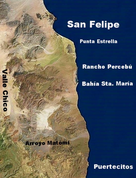
Note: I already see that the map doesn't include enough of Valle Chico to show the Sierra canyons, plus the text font is too big. As I said, this is a
test! Thank you!!
[Edited on 12-11-2017 by David K]
|
|
|
PaulW
Ultra Nomad
Posts: 3005
Registered: 5-21-2013
Member Is Offline
|
|
David what you want to do do is what we all do with our GPS mapping stuff.
Garmin has free maps for the world. Download an install on your device, phone, tablet, GPS, etc. Then add the custom details you want/need. Maps can
be even can be installed on your pc to allow picking and choosing specific required areas of interest. Lots of education and time is required to get
up to speed.
There are also pay for maps that probably are even better than the free ones. A starting place would be "Open street maps".
You need a collection of Garmin software to do all this. "Mapsource", "Basecamp" and others specific to the map you choose and the device you are
using to create the detail.
My fastest way would is to load GPS tracks onto GE the make a screen shot and use "Paint" to add text and symbols. Pretty crude but functional. Get
your GPS tracks from Your Inreach tracks and edit them to get rid of the straight lines. I use "Trackmaker" for that task.
Have fun.
|
|
|
David K
Honored Nomad
Posts: 64479
Registered: 8-30-2002
Location: San Diego County
Member Is Offline
Mood: Have Baja Fever
|
|
This is to do on my desktop, not any mobile device. Thank you for any help!
|
|
|
mtgoat666
Select Nomad
Posts: 17291
Registered: 9-16-2006
Location: San Diego
Member Is Offline
Mood: Hot n spicy
|
|
GE can do basics. But poor graphic choices, cant adjust fonts.
Suggest you also consider QGIS (free open source) or ArcMap (ESRI $$).
Whatever you do, you will probably want to output graphics from GIS program, then edit in a graphics program like adobe Illustrator.
Woke!
“...ask not what your country can do for you – ask what you can do for your country.” “My fellow citizens of the world: ask not what America
will do for you, but what together we can do for the freedom of man.”
Prefered gender pronoun: the royal we
|
|
|
JZ
Elite Nomad
Posts: 9226
Registered: 10-3-2003
Member Is Offline
|
|
Fiverr bud. Don't try to do it on your own. Get an idea of what you want. Maybe even reach out to a local designer to get their ideas.
Then farm it out. The amount of talent on Fiverr is unbelievable and super cheap.
Anything you want. Voice over, video editing, photo editing, graphic design, copy writing, you name it.
A professional will do much better work then you can and faster. You need to be the expert, project owner, review the work. Let the guy in India be
the graphics talent.
https://www.fiverr.com/
[Edited on 11-14-2017 by JZ]
|
|
|
PaulW
Ultra Nomad
Posts: 3005
Registered: 5-21-2013
Member Is Offline
|
|
==== ==
All the things I mentioned can be done an a pc. The software mentioned are for a PC.
GE can result in some pretty good maps if you can fine a good editing software. "paint" is just my way. For sure GE alone wont cut it.
|
|
|
David K
Honored Nomad
Posts: 64479
Registered: 8-30-2002
Location: San Diego County
Member Is Offline
Mood: Have Baja Fever
|
|
Thanks Paul and Goat for some input I will explore.
I guess that issue is I want to do this soon without having to take a 'college course' first (lol). Maybe I am just feeling worn out after 20,000
miles driving all over Baja this year!?
You see the space map I was able to make easily above (using Flash Earth and Photobucket)? Flash Earth might be better than Google Earth for me
because there isn't already stuff added in?
Well, the next step is adding a line or parallel lines to show roads. Maybe in Paint? I will try!
JZ, this is something that I want to produce and not farm out to India, but thank you still!
I greatly appreciate constructive suggestions and your patience with me as I feel a bit maxed out! 
|
|
|
norte
Super Nomad
Posts: 1163
Registered: 10-8-2008
Member Is Offline
|
|
Sometimes easy is not the best way. Especially if you want to build a guide that is marketable. Maybe you should take the suggestion to outsource
it.
[Edited on 11-14-2017 by norte]
|
|
|
David K
Honored Nomad
Posts: 64479
Registered: 8-30-2002
Location: San Diego County
Member Is Offline
Mood: Have Baja Fever
|
|
That will be up to the publisher. I was just hoping to create something a level up from hand drawn, which I have done for most of my life...
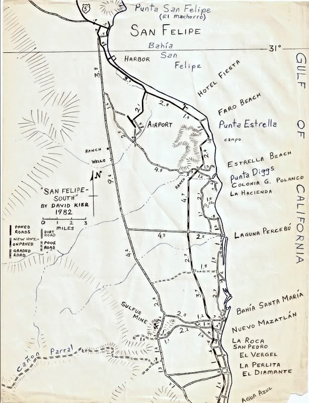
Some of the best or more user-friendly Baja maps were hand-drawn, from before the computer age:
1962 Gulick Maps:
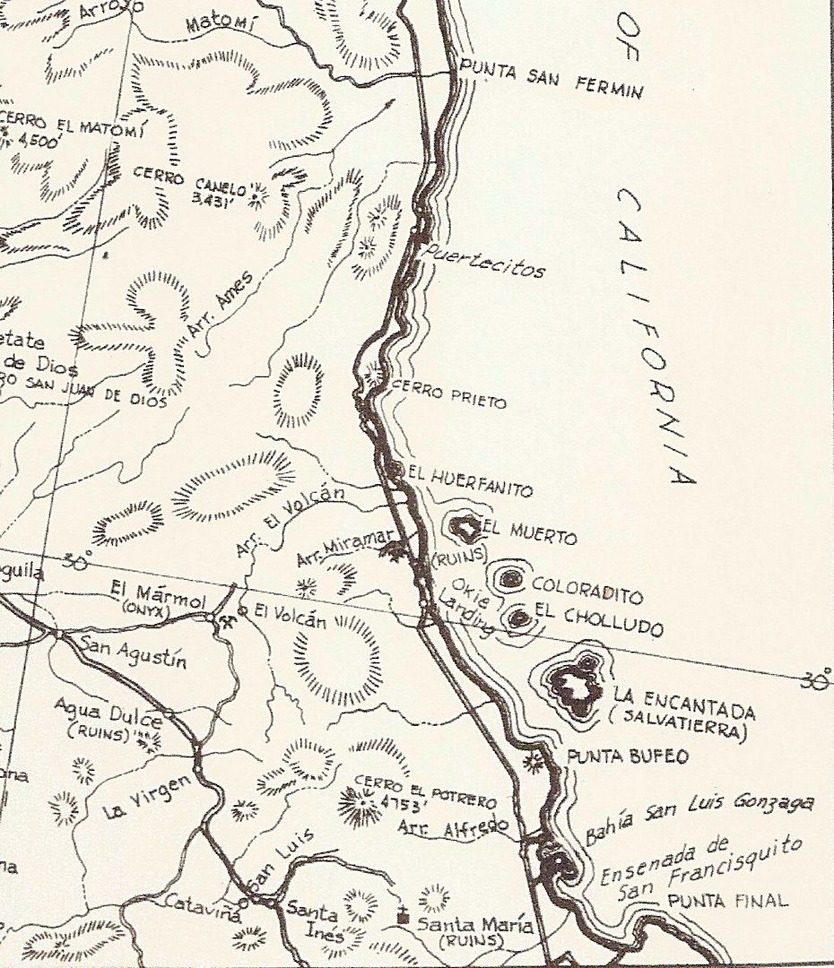
1970 Cross Maps:
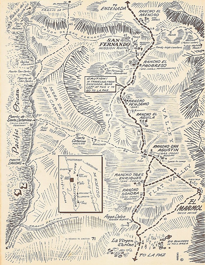 ] ]
1982 'David K' Maps:
|
|
|
JZ
Elite Nomad
Posts: 9226
Registered: 10-3-2003
Member Is Offline
|
|
It's not just India, ppl from all over the world, including the US.
End result would be much better.
|
|
|
Archie
Nomad
Posts: 163
Registered: 4-23-2012
Member Is Offline
|
|
I use QGIS, there's a plugin that lets you use GE, Bing, USGS, NASA and other satellite based imagery as background.

I usually create my routes on GE or download from my gps my tracks and waypoints, then import to QGIS all the stuff to create my maps.
It has a its own map designer to print or export in any commercial format, you can add almost any feature you may need on the map, and you can edit
almost anything.
I've found it very useful, even more than ArcMap, which by the way, it's not available anymore.
Another bonus, its that there's available (usually for free) almost any information you may need, from power lines, soil types, vegetation, roads,
geological, hydrological, and many many more.
|
|
|
David K
Honored Nomad
Posts: 64479
Registered: 8-30-2002
Location: San Diego County
Member Is Offline
Mood: Have Baja Fever
|
|
Thank you Archie.
I actually want very simple data to appear on the map. Readers can use it to see the relative positions of points to each other. The road log has
plenty of detail.
I will search for QGIS!
Gracias!
|
|
|
Archie
Nomad
Posts: 163
Registered: 4-23-2012
Member Is Offline
|
|
Cool 
Any GIS software can be a bit overwhelming, if you don't need that much power, then GE can be your best bet.
I guess you already know how to edit a track or route, and how to change the icon for the waypoints.
In GE Pro you can create a custom map for printing or export, it will display only the layers you have selected.
If you want to give it a try, go to File, then Save as and select Save image, you'll have something like this:

In the box on the upper right that says "Legend", you can click on it and edit the names of the features displayed on the map.
Its way more simple than a GIS map, you can select if you want to have a only a scale bar, the compass, the box with the features of the selected
layers and a box with an editable title and description.

Goat was correct in terms of that you can't edit some things, like the font, but you can change the color and the size. Also you can select the
resolution of your map.

I have some files with most of the data (roads, towns, POI) of Baja California and Baja Sur, if you need something very specific, just ask.
[Edited on 11-15-2017 by Archie]
[Edited on 11-15-2017 by Archie]
|
|
|
AKgringo
Elite Nomad
Posts: 5805
Registered: 9-20-2014
Location: Anchorage, AK (no mas!)
Member Is Online
Mood: Retireded
|
|
"...if you need something very specific, just ask."
David, that is usually your line! I think you have found a new best friend!
[Edited on 11-15-2017 by AKgringo]
If you are not living on the edge, you are taking up too much space!
"Could do better if he tried!" Report card comments from most of my grade school teachers. Sadly, still true!
|
|
|
David K
Honored Nomad
Posts: 64479
Registered: 8-30-2002
Location: San Diego County
Member Is Offline
Mood: Have Baja Fever
|
|
Thanks AK, having Baja Nomad friends is a good thing!
Archie, I am following your steps, but when I click on the Legend box, a pencil image appears and a blank, edit box pops up down on the map. There is
no list of items to edit, as your image shows?
Perhaps we can take this to email or u2u?
|
|
|
David K
Honored Nomad
Posts: 64479
Registered: 8-30-2002
Location: San Diego County
Member Is Offline
Mood: Have Baja Fever
|
|
Just an update... with help from Nomads (John M in particular), and many hours of trying... I think I can create maps that will work with the
roadguide.
I want maps to be accurate, to show the true coastline, the true location of roads, and one that I can pick what to show on it.
There are many many roads, but for the sake of clarity, I only want to show roads in the guide or mentioned in the guide... Same is true of campos and
other sites. In the San Felipe area are dozens and dozens of 'campos'. However, they are mostly private home developments are not usually a place for
vacationing campers to set up. As the guide is to assist travelers to Baja, only campos that cater to camping are shown.
I found a mapping site that allows me to use satellite images that I can pencil over roads I have been on or are in the guide and then switch to a
plain map with some topography but few names (that often do not reflect the actual place name). The roadguide has all the mileages and kilometer
markers for the roads. These maps are more to give an overall view of where they are in relation to each other when using the guide and not a
stand-alone map for navigation. The guide is the navigation source... and the maps help to see the area the guide covers, as were the maps in the
Lower California Guidebook.
This is not finished or refined but shows what I was trying to do. Thank you John M for assisting me (I needed help with icons and other tools for
making this)! StuckSucks has also offered some ideas, too.
In this edit, I have kilometer markers along roads that have them at key locations. I use simply K but if less than 10, I use Km. This to help the
smaller figures stand out as much as the others.
I had to splice two maps together. Does anyone have a simple method to eliminate the thin white line where the two meet? I used the colored line
drawing tool to color in the ocean and roads. If there is a way to mate up two images instead, that would be better??
Thank you for your interest in this project!
Oh, did I read that the Morelia/Saltito/Valle Chico road (Km. 181) was getting paved since I was there last? How far is the paving going? I can easily
change part of it to a paved road.
I am pretty happy that after all the time trying to create something I want short of hand drawing it, this may work!
[Edited on 12-19-2017 by David K]
|
|
|
TMW
Select Nomad
Posts: 10659
Registered: 9-1-2003
Location: Bakersfield, CA
Member Is Offline
|
|
That looks pretty good David.
When I was down there the end of Oct the pavement put down was only a couple of miles. I don't remember how far the prep work was done.
|
|
|
PaulW
Ultra Nomad
Posts: 3005
Registered: 5-21-2013
Member Is Offline
|
|
Morelia road has tar base part way to the power line Still has the orange thing so people wont drive on the stuff. New road grade is done with road
base to the 2nd culvert. Nothing after that.
DK, Your map is excellent
|
|
|
David K
Honored Nomad
Posts: 64479
Registered: 8-30-2002
Location: San Diego County
Member Is Offline
Mood: Have Baja Fever
|
|
Thank you!
I will pave a couple miles of that road in the next edit.
Baja Angel and I are in the movie theater waiting for Dust 2 Glory to start!
|
|
|
mtgoat666
Select Nomad
Posts: 17291
Registered: 9-16-2006
Location: San Diego
Member Is Offline
Mood: Hot n spicy
|
|
cool.
what map software/program are you using?
Woke!
“...ask not what your country can do for you – ask what you can do for your country.” “My fellow citizens of the world: ask not what America
will do for you, but what together we can do for the freedom of man.”
Prefered gender pronoun: the royal we
|
|
|
| Pages:
1
2
3
4 |


