| Pages:
1
2
3
4 |
BajaTed
Senior Nomad

Posts: 859
Registered: 5-2-2010
Location: Bajamar
Member Is Offline
|
|
If you have MS Office.
Paste your Sat/Map pictures in a blank MS Visio template and edit to your hearts desire with fonts, arrows,etc.
Place the finished product in a blank MS powerpoint slide for presentations or publish.
Standard manner used in most consulting firms
Es Todo Bueno
|
|
|
David K
Honored Nomad
Posts: 64476
Registered: 8-30-2002
Location: San Diego County
Member Is Offline
Mood: Have Baja Fever
|
|
ArcGIS for first steps, then Word for additional edits.
I will see if I can figure out this Visio program that Ted mentioned...
|
|
|
mtgoat666
Select Nomad
Posts: 17282
Registered: 9-16-2006
Location: San Diego
Member Is Offline
Mood: Hot n spicy
|
|
Quote: Originally posted by David K  |
ArcGIS for first steps, then Word for additional edits.
I will see if I can figure out this Visio program that Ted mentioned... |
Arcgis is the best for what you want. Though very expensive!
Woke!
“...ask not what your country can do for you – ask what you can do for your country.” “My fellow citizens of the world: ask not what America
will do for you, but what together we can do for the freedom of man.”
Prefered gender pronoun: the royal we
|
|
|
David K
Honored Nomad
Posts: 64476
Registered: 8-30-2002
Location: San Diego County
Member Is Offline
Mood: Have Baja Fever
|
|
I am using a free version. Maybe that is why there are so few things I can add and why I need to use Word to add more?
|
|
|
David K
Honored Nomad
Posts: 64476
Registered: 8-30-2002
Location: San Diego County
Member Is Offline
Mood: Have Baja Fever
|
|
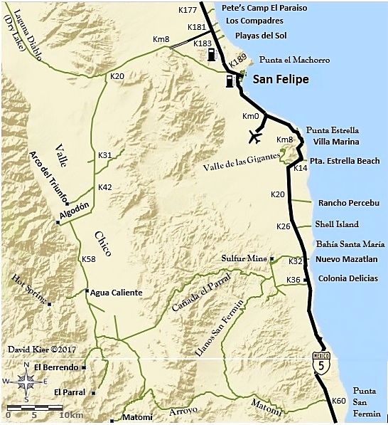
San Felipe area map edit...
OK, so I added gas pumps and a jet plane (for the airport)... plus a copyright note and date ©, a couple other little things.
I think I will now work on my trip from Cd. Constitucion to Mission San Luis Gonzaga, La Pasion, Dolores overlook and on to San Evaristo!
As these take some time and effort... I plan to make maps only of the areas where a visual addition to the road guide contents would be a real boost.
I may keep on doing more and more... but, I do need to do other things!
To keep me drawing maps and writing: contact me for my books, tour guide service, travel planning, or irrigation systems and repairs (in N. San Diego
County)! 
[Edited on 12-15-2017 by David K]
|
|
|
David K
Honored Nomad
Posts: 64476
Registered: 8-30-2002
Location: San Diego County
Member Is Offline
Mood: Have Baja Fever
|
|
Ciudad Constitución to San Evaristo and 3 missions.
Today's map project...
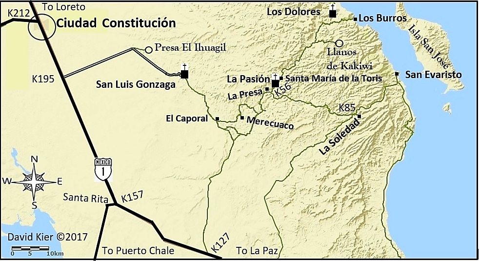
This is the first test run... I see a couple things to fix already, lol! The only Pemex stations in this area are at Constitución, so I don't think I
will stuff a pump icon in the city circle. These maps are to help visualize where the roads mentioned in my road guide are in relation to each other
and do not intend to show all that is there... the road guide does that well enough. Also, in addition to the road into San Luis Gonzaga from Hwy. 1
being a well-graded road, the road passing La Presa to La Soledad (with a couple kilometer markers along it) is also well-graded... I just didn't want
to fill the maps with too much extra detail. It gets too busy to be easy to look at at some point.
|
|
|
David K
Honored Nomad
Posts: 64476
Registered: 8-30-2002
Location: San Diego County
Member Is Offline
Mood: Have Baja Fever
|
|
Tijuana to El Tigre
Update:
A revised version of the Tijuana Area Map:
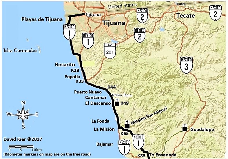
[Edited on 12-15-2017 by David K]
|
|
|
David K
Honored Nomad
Posts: 64476
Registered: 8-30-2002
Location: San Diego County
Member Is Offline
Mood: Have Baja Fever
|
|
Ensenada/Santo Tomás area map:
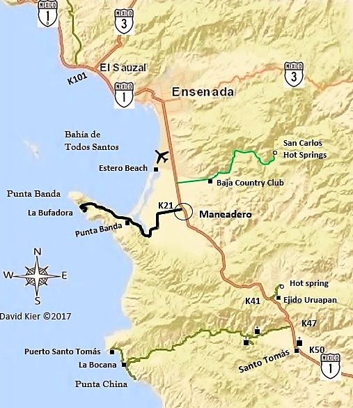
Some improvements/additions...
[Edited on 12-27-2017 by David K]

|
|
|
David K
Honored Nomad
Posts: 64476
Registered: 8-30-2002
Location: San Diego County
Member Is Offline
Mood: Have Baja Fever
|
|
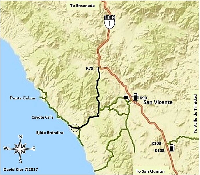
Some edits...
[Edited on 12-27-2017 by David K]

|
|
|
MMc
Super Nomad
Posts: 1679
Registered: 6-29-2011
Member Is Offline
Mood: Current
|
|
The hypocrisy of you copyrighting your work, while posting other's copyright protected work is astounding. Not surprising, just astounding.
,
| Quote: Originally posted by David K | OK, so I added gas pumps and a jet plane (for the airport)... plus a copyright note and date ©, a couple other little things.
I think I will now work on my trip from Cd. Constitucion to Mission San Luis Gonzaga, La Pasion, Dolores overlook and on to San Evaristo!
As these take some time and effort... I plan to make maps only of the areas where a visual addition to the road guide contents would be a real boost.
I may keep on doing more and more... but, I do need to do other things!
To keep me drawing maps and writing: contact me for my books, tour guide service, travel planning, or irrigation systems and repairs (in N. San Diego
County)!
Latest version San Felipe Region:
 |
"Never teach a pig to sing it frustrates you and annoys the pig" - W.C.Fields
|
|
|
MMc
Super Nomad
Posts: 1679
Registered: 6-29-2011
Member Is Offline
Mood: Current
|
|
Both the AAA map and Almanac have a copyright on them. The Almanac even states that "No part of the publication may be reproduced or transmitted,
Mechanically or electronically, including camera, photocopying,digital scanner or any data storage or retrieval system unless approved in writing from
the publisher."
I have stayed off this thread as I dislike maps being posted here. I beleive that Info should be shared person to person, but what do I know.
https://en.wikipedia.org/wiki/Copyright_infringement
"Never teach a pig to sing it frustrates you and annoys the pig" - W.C.Fields
|
|
|
PaulW
Ultra Nomad
Posts: 3005
Registered: 5-21-2013
Member Is Offline
|
|
MMc, What you said id true, but the source material is not copy protected and is available for download free directly from the Mexican government. The
author of the Almanac adds very little content to the source material. David and I have been using this original content for our own purposes for
years. That content cannot be copy protected unless the Mexican government does it. Not a likely thing to happen.
The AAA maps are copy protected and cannot be used for profit. just like the Almanac. For profit is the key word. That statement (Not for profit) has
been thru the courts and there is no conflict.
|
|
|
MMc
Super Nomad
Posts: 1679
Registered: 6-29-2011
Member Is Offline
Mood: Current
|
|
I am very familiar with IP law in America.
I just see it as funny and hypocritical that DK is copywriting it.
Profit isn't completely the issue with copyright, it is damages, but this just going down the IP law rabbit hole. I am done here.
"Never teach a pig to sing it frustrates you and annoys the pig" - W.C.Fields
|
|
|
David K
Honored Nomad
Posts: 64476
Registered: 8-30-2002
Location: San Diego County
Member Is Offline
Mood: Have Baja Fever
|
|
1) I am not using the Almanac or AAA map, but an online map making site FOR MAKING MAPS.
2) THESE MAPS I AM MAKING ARE FREE... You don't even pay to look at Baja Nomad, either... all free. No "for profit" here. For loss, maybe!!
3) How is sharing a map in person noble but not with Baja friends here on the Internet? I can help or entertain more Baja loving people on Nomad than
I ever could in person.
4) I am sharing here to get input on ways to IMPROVE the maps for EVERYONE.
5) Once again, I am not selling them, they are right here for you all to enjoy and give me ideas about.
6) You don't want to see my maps? Don't look at them... the thread topic says what is in here. No accidental map viewing possible! LOL
|
|
|
David K
Honored Nomad
Posts: 64476
Registered: 8-30-2002
Location: San Diego County
Member Is Offline
Mood: Have Baja Fever
|
|
San Pedro Mártir Area
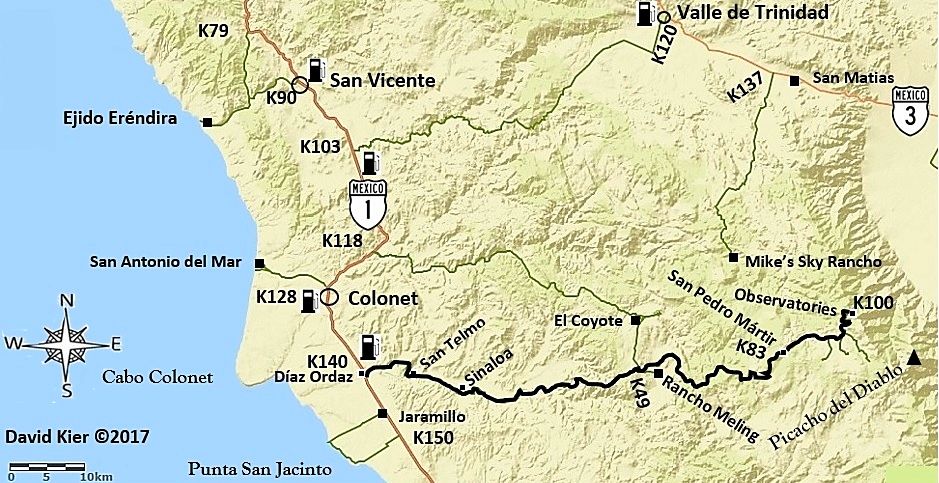
This map is for the observatory highway (black line) and other area roads described in the roadguide.
I have also been editing the other maps I have shared here making improvement and John M has been a big help creating icons for the map (highway
signs, gas pumps, jet planes, missions, etc.).
The actual drawing in of roads I am including and placing icons and text for names and km. markers, etc. takes up to 8 hours per map, so far.
Believe me, using someone else's maps would be a whole lot easier!
|
|
|
StuckSucks
Super Nomad
Posts: 2305
Registered: 10-17-2013
Member Is Offline
|
|
How to keep fellow cartographers honest: Trap street
|
|
|
geoffff
Senior Nomad
Posts: 643
Registered: 1-15-2009
Member Is Offline
|
|
Hey David, I love your maps!
You're not actually "drawing" the roads by hand, are you? I would assume you could import GPS tracks from your travels.
-- Geoff
|
|
|
David K
Honored Nomad
Posts: 64476
Registered: 8-30-2002
Location: San Diego County
Member Is Offline
Mood: Have Baja Fever
|
|
| Quote: Originally posted by geoffff |
Hey David, I love your maps!
You're not actually "drawing" the roads by hand, are you? I would assume you could import GPS tracks from your travels.
-- Geoff |
I am drawing in the roads you see by hand (using a mouse) with the exception of Federal Highways, which are on the base map. I draw over the satellite
image on the roads I drove and want to include on the map. Then I convert the satellite map to the base map I am using and the roads I drew in also
transfer. It is a lot of work, but getting a bit easier as I work out the process. I am down to about 4 hours per map from 8.
I am working on El Rosario to Catavña now... but will take a break to watch the new Star Wars movie with Elizabeth, my son, and his fiancé.
|
|
|
David K
Honored Nomad
Posts: 64476
Registered: 8-30-2002
Location: San Diego County
Member Is Offline
Mood: Have Baja Fever
|
|
First version El Rosario to Cataviña
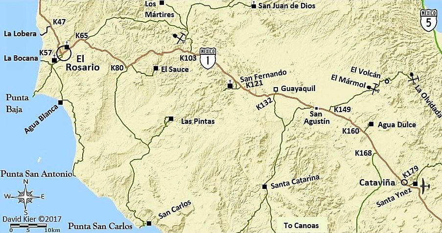
Thanks to John M for creating the cool mine and airplane symbols!
|
|
|
TMW
Select Nomad
Posts: 10659
Registered: 9-1-2003
Location: Bakersfield, CA
Member Is Offline
|
|
David on the San Felipe map above you show several K numbers on the west side. Did you calculate them yourself or are there KM signs posted along the
way? Also what is at K58?
|
|
|
| Pages:
1
2
3
4 |


