| Pages:
1
2
3
4 |
Udo
Elite Nomad

Posts: 6321
Registered: 4-26-2008
Location: Black Hills, SD/Ensenada/San Felipe
Member Is Offline
Mood: TEQUILA!
|
|
I gotta throw in my dos centavos here:
Superb effort DK, and excellent maps. Graham MacIntosh spent a few days at my house in Ensenada this week, and some of our discussion topic was
southern Baja. We used the Baja Almanac a lot.
Your name was mentioned a number of times during our information exchange.
Udo
Youth is wasted on the young!
|
|
|
David K
Honored Nomad
Posts: 64476
Registered: 8-30-2002
Location: San Diego County
Member Is Offline
Mood: Have Baja Fever
|
|
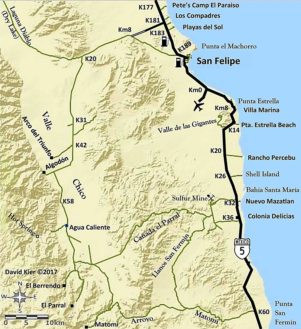
Quote: Originally posted by TMW  | | David on the San Felipe map above you show several K numbers on the west side. Did you calculate them yourself or are there KM signs posted along the
way? Also what is at K58? |
Hi Tom,
Yes, those are the actual location of highway kilometer markers, as close to exact as possible with a map of such large scale.
I place them at important road junctions or points that are mentioned in the road log from the guide. In the guide, I use more exact points, like if
the point is half a kilometer past a marker, I will label that point as Km.XX.5. On the map, however, I will just say Km.XX and place it just before
the point... The idea is that you can glance at a map and see what kilometer marker is close to the point you want to find.
As for Km. 58 in Valle Chico, that just happened to be the final kilometer marker along the road and it is a half kilometer north of that abandoned
farm with the elevated water tank (east side of road). I think some maps called it Linda Vista?
The maps are not stand-alone but are made specifically to use with my road logs as a visual aid to where you are in relation to other places and other
roads. Details on the map are matched with what is in the road log and very little else, to keep the maps easy to use.
Thank you for your interest.
|
|
|
David K
Honored Nomad
Posts: 64476
Registered: 8-30-2002
Location: San Diego County
Member Is Offline
Mood: Have Baja Fever
|
|
| Quote: Originally posted by Udo | I gotta throw in my dos centavos here:
Superb effort DK, and excellent maps. Graham MacIntosh spent a few days at my house in Ensenada this week, and some of our discussion topic was
southern Baja. We used the Baja Almanac a lot.
Your name was mentioned a number of times during our information exchange. |
Thank you, Udo,
I have known Graham personally since we met in 1990 at one of his early slide shows... My wife was very pregnant and a bit uncomfortable, but we
wanted to hear and see Graham. My daughter was born the next day!
When Graham was doing the writing of his second book, Journey with a Baja Burro, I acted as his 'Internet secretary' passing info and comments between
him and the Amigos de Baja forum members. We have gone together to various Baja functions 10-15 years ago, as well.
Graham is a very enjoyable lecturer and talented Baja authority. The English accent is just frosting on the cake!
Happy Holidays to you and Jana!
|
|
|
TacoFeliz
Nomad
Posts: 265
Registered: 7-22-2005
Location: Here
Member Is Offline
Mood: Exploratory
|
|
Really nice work David! Looking forward to seeing where all this leads.
Jay
|
|
|
David K
Honored Nomad
Posts: 64476
Registered: 8-30-2002
Location: San Diego County
Member Is Offline
Mood: Have Baja Fever
|
|
Thanks, Jay!
It has been almost a year since I began this project for Baja Bound Insurance... 7 expeditions, each lasting from 6-14 days... nearly 20,000 miles of
driving all over Baja in 2017... and then putting it all on paper (or on screen). Making these maps is the final raw work before it all goes together.
Editing is so key. I am getting great help from Nomads like John M, with good eyes and guidebook writing experience. The author of the final auto club
Baja guidebook is having lunch with me today as he has been giving me feedback too. He loves Baja very much and it was very sad when the Auto Club of
Southern California ended their 90 years of giving us so many Baja books and maps!
I just made some fine tuning to the San Felipe area map:
Edit: Taco Felix did a great job removing the splice line, thank you!
[Edited on 12-19-2017 by David K]
|
|
|
PaulW
Ultra Nomad
Posts: 3005
Registered: 5-21-2013
Member Is Offline
|
|
David,
It might be a good idea to come up with a way to mark the KM on the way to Algodon, because nobody will be able to find any KM markers. Maybe
something like Italics or Prens?
Good work - keep it up.
|
|
|
David K
Honored Nomad
Posts: 64476
Registered: 8-30-2002
Location: San Diego County
Member Is Offline
Mood: Have Baja Fever
|
|
| Quote: Originally posted by PaulW | David,
It might be a good idea to come up with a way to mark the KM on the way to Algodon, because nobody will be able to find any KM markers. Maybe
something like Italics or Prens?
Good work - keep it up. |
I added them on the map because they were there. The log includes them with miles.
The road log uses miles where kilometer posts are missing or inconsistent since the majority of users of it have vehicles that are reading miles.
On the graded roads that have some kilometer markers, they are included in the guide along with the odometer miles log.
Here is a sample of the road log to Valle Chico:
0.0 Miles: Highway 5 at Km. 181, north of San Felipe at the Colonia Morelia road. There are some kilometer posts are along this road.
4.3 (Km. 7+) El Dorado Ranch resident road (from Km. 178.5) junction. This was once known as the ‘Zoo Road’ as it began where a curio store sold
carved-wood animals on Highway 5, a ‘zoo’ of animals.
5.1 (Km. 8.5) Join the original Ensenada-San Felipe road (from or to Km. 189+).
12.5 Cattle guard.
12.8 (Km. 20.5+) Fork. Right (west) to Diablo Dry Lake (original road to Ensenada, signed ‘Colonia San Pedro Mártir’). Log continues, using the
left fork, south to Matomí.
19.5 (Km. 31.5) Fork. Right (west) to Rancho El Cajon. Continue going south taking the left fork for Valle Chico and Matomí.
Baja California’s highest peak, Picacho del Diablo can be seen throughout the region.
24.6 Junction. Continue straight/south. The road to the east from here is often used for racing going back to San Felipe.
25.9 Cattle guard.
26.0 (Km. 42) Road right (west) goes to Arco del Triunfo, a drug rehab center.
29.6 Cattle guard.
31.5 Crossroad. Ahead (west) for Rancho Algodón and the old road north along the base of the mountain. Turn left (south) for Agua Caliente, El
Berrendo, and Matomí.
|
|
|
David K
Honored Nomad
Posts: 64476
Registered: 8-30-2002
Location: San Diego County
Member Is Offline
Mood: Have Baja Fever
|
|
Here's the next one...
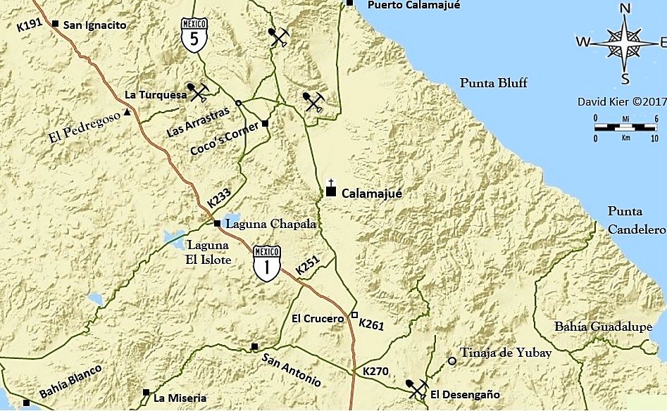
Notice I put in the new Hwy. 5 route that bypasses Coco's Corner.
|
|
|
David K
Honored Nomad
Posts: 64476
Registered: 8-30-2002
Location: San Diego County
Member Is Offline
Mood: Have Baja Fever
|
|
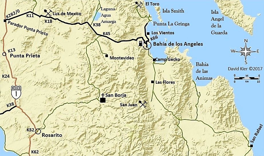
There are several steps...
Selecting the overall area to show.
Drawing in all the dirt or paved roads I want to include. In this case, all roads that are in the road guide's road logs or mentioned in the road
guide.
[The base map only has Highway 1 and nothing else, in this zone at this scale. I had to draw in the L.A. Bay highway as well as all the unpaved roads]
So, I think when I get back to this, I will thicken the line for the L.A. Bay highway, and make it black, to differentiate from the unpaved roads.
I also need to add the Highway 1 sign icon.
I think I won't try and squeeze in airplanes at Punta Prieta and L.A. Bay?
Maybe a gas pump at L.A. Bay?
Thanks for your feedback and the assistance via email and u2u, amigos!
[Edited on 12-19-2017 by David K]
|
|
|
PaulW
Ultra Nomad
Posts: 3005
Registered: 5-21-2013
Member Is Offline
|
|
Just an observation
If you had made a GPS track for your travels the effort would have been hugely less intensive.
I like your final product
|
|
|
David K
Honored Nomad
Posts: 64476
Registered: 8-30-2002
Location: San Diego County
Member Is Offline
Mood: Have Baja Fever
|
|
| Quote: Originally posted by PaulW | Just an observation
If you had made a GPS track for your travels the effort would have been hugely less intensive.
I like your final product |
Thanks, Paul. I did make GPS tracks and that is why I was so disappointed in the InReach map adding straight lines in many places that I could not get
a answer on how to remove them from the map.
In my 2017 trip reports, I included many of the track maps. They helped me know where I was driving and I simply drew them in over the satellite base
map before converting to the terrain map I am using here.
|
|
|
David K
Honored Nomad
Posts: 64476
Registered: 8-30-2002
Location: San Diego County
Member Is Offline
Mood: Have Baja Fever
|
|
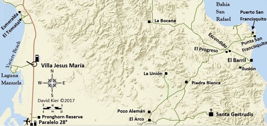
Latest version: Paved roads into L.A. Bay, La Gringa, Santa Rosalillita; Gas Pump; Larger mission icon.
|
|
|
David K
Honored Nomad
Posts: 64476
Registered: 8-30-2002
Location: San Diego County
Member Is Offline
Mood: Have Baja Fever
|
|
The steps...
Since this is a How To Make Maps Q & A thread and Nomads have been super with help, let me see if I can visualize the steps. Maybe MORE Nomads
will begin making maps and help others find a Baja paradise and improve the lives of those in Baja who benefit from the visitors who come to Baja.
OK Step 1 is to pick a region of Baja. So far, I have done two scales as you can see from the scale bars on the maps. One is 6 km. bar and allows
better detail if many roads or points are in the area of interest. The other is 10 km. and can cover from Pacific to Cortez or larger areas of Baja.
This is the scale I am doing more at.
The next map I will make will be from the bottom of my previous one, approx. Punta Rosarito on the Pacific and Pancho's San Rafael, on the gulf south
to the state border.
Here is the base map at 10 km. scale and basically it gives you the coastline, mountains, and Highway 1, almost nothing else. Maps are all oriented
with north at the top, but I add a compass rose because I think it is cool to have one on a map.
This is my base map, without enhancement, everything else you will see I add to it. I cropped the bottom of it at the state border and I removed a
small toolbar for changing the size of the map by coloring over it, if you have good color vision, you may see the slightly different shade of blue in
the upper left corner:
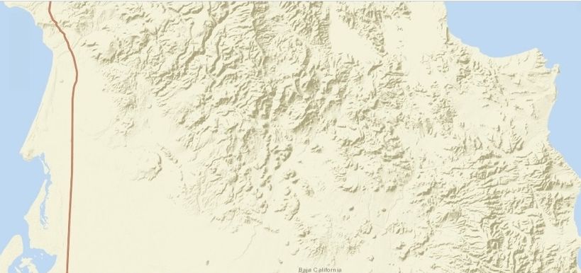
So, besides topography and the ocean/gulf only Highway 1 is shown and the state name along the border.
STEP 2
Add in the roads I want to show. These are roads I traveled this year that are being included in the Guide (exception is the Valle La Bocana road).
Other than Highway 1, all the roads are hand drawn in traced from the satellite image. The base map can be switched from the Road map to Satellite
image, then a pencil or line tool allows one to draw in the roads desired.
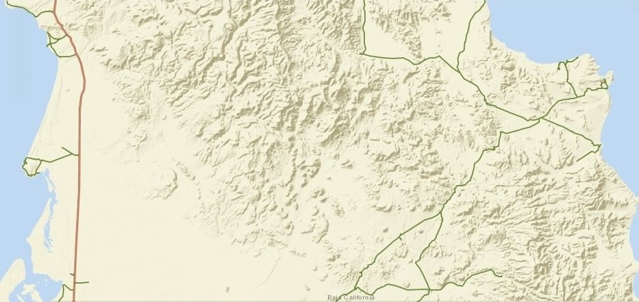
Next step (after a break, as I am exhausted and hungry) will be to add in icons for highway signs, gas pumps, airports, missions, the compass and
scale bar. I also then add in the place names and small black squares or circles for places on the map.
STEP 3: Add most of the rest! Names, Symbols, Icons, I even added a road I forget to earlier (to La Unión). I think I just need to add Km. markers
along Hwy. 1 and then enhance the image...
STEP 4: Add in the kilometer markers at the desired locations. Again, these additions are all done in Word. The text is added in using the Text Box:
Draw Text Box choice. The font size is adjusted if needed and generally, I make the font bold to be easier to read. For terrain/ocean names I use a
different font. The whole idea is to customize to fit the map.
Besides adding the km. marker points, I also noticed I needed to add a road out to the old Laguna Guerrero Negro salt dock.
Finally, I enhance the map colors in my Photobucket hosting Photo Editing feature....

I can always go back to the map, saved in Word, and add more.
The steps from Word to Nomad are numerous and perhaps there is a better way. This just how I figured out how, so if you want to do the same, maybe it
will help?
A) Get Base Map. I used ArcGIS and chose the base map "Streets" but flipped back to "Imagery" (satellite view) and edited with "Map Notes" to draw in
roads. Once done, I use Print Screen (on the keyboard) and then Paint, Paste, Save... convert PNG to JPEG, Save. Then go to Documents, Pictures, Edit,
Crop, Close File.
B) Open up Word and pick a blank sheet and the Insert, Picture (pick the maps I just saved in Pictures), and begin to add in icons, roads, text all
using Insert (Pictures, Shapes, Text Box).
C) When done, click on the map, click Format, click Corrections and fine tune the map image, if needed. Have the map (on Word) as large as the window
will allow without cutting the map off and then perform the Print/Paste operation again (Paint, Paste, Save... convert PNG to JPEG, Save. Then go to
Documents, Pictures, Edit, Crop, Close File).
Anyway, that is my method (for now) and if you want to try and make maps to show, I hope this tutorial will be of assistance. Feel free to email or
u2u me any questions.
[Edited on 12-20-2017 by David K]
|
|
|
David K
Honored Nomad
Posts: 64476
Registered: 8-30-2002
Location: San Diego County
Member Is Offline
Mood: Have Baja Fever
|
|
Edit with improved size scale bar
The scale bar was pretty tiny to see/use. A big thank you to Taco Felix for making a larger one to use...
John M has also been a super help with all the symbols/icons he has provided!
|
|
|
mtgoat666
Select Nomad
Posts: 17282
Registered: 9-16-2006
Location: San Diego
Member Is Online
Mood: Hot n spicy
|
|
| Quote: Originally posted by David K |
A) Get Base Map. I used ArcGIS and chose the base map "Streets" but flipped back to "Imagery" (satellite view) and edited with "Map Notes" to draw in
roads. Once done, I use Print Screen (on the keyboard) and then Paint, Paste, Save... convert PNG to JPEG, Save. Then go to Documents, Pictures, Edit,
Crop, Close File.
B) Open up Word and pick a blank sheet and the Insert, Picture (pick the maps I just saved in Pictures), and begin to add in icons, roads, text all
using Insert (Pictures, Shapes, Text Box).
C) When done, click on the map, click Format, click Corrections and fine tune the map image, if needed. Have the map (on Word) as large as the window
will allow without cutting the map off and then perform the Print/Paste operation again (Paint, Paste, Save... convert PNG to JPEG, Save. Then go to
Documents, Pictures, Edit, Crop, Close File).
Anyway, that is my method (for now) and if you want to try and make maps to show, I hope this tutorial will be of assistance. Feel free to email or
u2u me any questions.
[Edited on 12-20-2017 by David K] |
Word is a very poor graphics program.
You can do almost everything in Arcgis.
If uncomfortable with Arcgis, then export to Adobe Illustrator or MS Visio - they are pretty intuitive graphics programs.
Dont use Word for graphics!
Woke!
“...ask not what your country can do for you – ask what you can do for your country.” “My fellow citizens of the world: ask not what America
will do for you, but what together we can do for the freedom of man.”
Prefered gender pronoun: the royal we
|
|
|
DaliDali
Super Nomad
Posts: 1132
Registered: 4-21-2010
Location: BCS
Member Is Offline
|
|
| Quote: Originally posted by mtgoat666 |
Word is a very poor graphics program.
You can do almost everything in Arcgis.
If uncomfortable with Arcgis, then export to Adobe Illustrator or MS Visio - they are pretty intuitive graphics programs.
Dont use Word for graphics! |
Where are YOUR maps Goatly?
|
|
|
David K
Honored Nomad
Posts: 64476
Registered: 8-30-2002
Location: San Diego County
Member Is Offline
Mood: Have Baja Fever
|
|
ja ja ja...
I am using ArcGIS... That is the base map as I showed above. You can add lines and some basic stuff, but all that and more can be done on Word.
As for why I am using Word, it was shown to me as a way.
I need to work with as much free stuff as I can.
I only have limited Adobe, and Adobe Illustrator or other advanced programs require dinero. I am doing this map work on my own dime, and I have very
few dimes.
If you have any free methods for doing what I am doing more efficiently, please share the steps!
[Edited on 12-20-2017 by David K]
|
|
|
David K
Honored Nomad
Posts: 64476
Registered: 8-30-2002
Location: San Diego County
Member Is Offline
Mood: Have Baja Fever
|
|
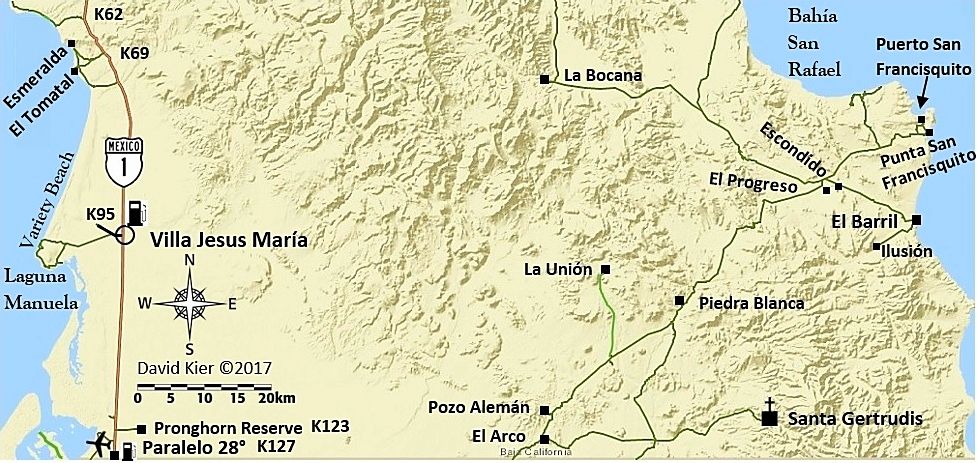
Here is today's map... so far>>>
[Edit, added "4WD" on two roads]
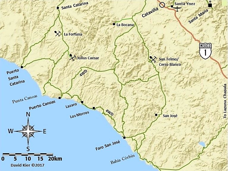
[Edited on 12-21-2017 by David K]
|
|
|
mtgoat666
Select Nomad
Posts: 17282
Registered: 9-16-2006
Location: San Diego
Member Is Online
Mood: Hot n spicy
|
|
Need to add notes and arrows for surf breaks, so guidebook is useful to surfers!
Perhaps Woody can mark up your map to illustrate breaks, campsites, etc 
Woke!
“...ask not what your country can do for you – ask what you can do for your country.” “My fellow citizens of the world: ask not what America
will do for you, but what together we can do for the freedom of man.”
Prefered gender pronoun: the royal we
|
|
|
David K
Honored Nomad
Posts: 64476
Registered: 8-30-2002
Location: San Diego County
Member Is Offline
Mood: Have Baja Fever
|
|
Nope, there are no surf breaks in Baja... only banditos, lost missions, and chupacabras!
|
|
|
| Pages:
1
2
3
4 |
|