| Pages:
1
2
3
4 |
4x4abc
Ultra Nomad

Posts: 4163
Registered: 4-24-2009
Location: La Paz, BCS
Member Is Offline
Mood: happy - always
|
|
David, do you have a reader for shp files?
since I am Mac based, I have limited options
Harald Pietschmann
|
|
|
David K
Honored Nomad
Posts: 64479
Registered: 8-30-2002
Location: San Diego County
Member Is Offline
Mood: Have Baja Fever
|
|
I guess not, as I don't know what that is?
I did get a u2u with a suggestion for a program... and I will play with that now.
|
|
|
Barry A.
Select Nomad
Posts: 10007
Registered: 11-30-2003
Location: Redding, Northern CA
Member Is Offline
Mood: optimistic
|
|
Excellent work, David. I applaud you!
QUESTION: Back in the old days ('50's and '60's) the "main road" (only road?) south from Diablo dry lake to Rancho Algodone ran along the base of the
Sierra SPM and was nothing more than a substantial dirt track but 2-wheel drive was fine most of the time. I notice that "road" is no longer on your
map, but you do make reference to it in your narrative, I think. Does that road no longer exist?
Quote: Originally posted by David K  |
Thanks, Jay!
It has been almost a year since I began this project for Baja Bound Insurance... 7 expeditions, each lasting from 6-14 days... nearly 20,000 miles of
driving all over Baja in 2017... and then putting it all on paper (or on screen). Making these maps is the final raw work before it all goes together.
Editing is so key. I am getting great help from Nomads like John M, with good eyes and guidebook writing experience. The author of the final auto club
Baja guidebook is having lunch with me today as he has been giving me feedback too. He loves Baja very much and it was very sad when the Auto Club of
Southern California ended their 90 years of giving us so many Baja books and maps!
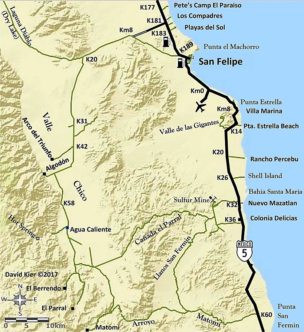
I just made some fine tuning to the San Felipe area map:
Edit: Taco Felix did a great job removing the splice line, thank you!
[Edited on 12-19-2017 by David K] |
|
|
|
StuckSucks
Super Nomad
Posts: 2306
Registered: 10-17-2013
Member Is Offline
|
|
| Quote: Originally posted by Barry A. |
QUESTION: Back in the old days ('50's and '60's) the "main road" (only road?) south from Diablo dry lake to Rancho Algodone ran along the base of the
Sierra SPM and was nothing more than a substantial dirt track but 2-wheel drive was fine most of the time. I notice that "road" is no longer on your
map, but you do make reference to it in your narrative, I think. Does that road no longer exist? |
You mean it ran more due south than passing thru Morelia Jct?
|
|
|
Barry A.
Select Nomad
Posts: 10007
Registered: 11-30-2003
Location: Redding, Northern CA
Member Is Offline
Mood: optimistic
|
|
| Quote: Originally posted by StuckSucks | | Quote: Originally posted by Barry A. |
QUESTION: Back in the old days ('50's and '60's) the "main road" (only road?) south from Diablo dry lake to Rancho Algodone ran along the base of the
Sierra SPM and was nothing more than a substantial dirt track but 2-wheel drive was fine most of the time. I notice that "road" is no longer on your
map, but you do make reference to it in your narrative, I think. Does that road no longer exist? |
You mean it ran more due south than passing thru Morelia Jct? |
Yes, Steve, and more west right along the base of the SPM. At that time, the Morelia road did not exist, as far as I know.
On Edit: The road I am talking about shows up clearly on the older editions of the BAJA ATLAS.
[Edited on 12-21-2017 by Barry A.]
|
|
|
StuckSucks
Super Nomad
Posts: 2306
Registered: 10-17-2013
Member Is Offline
|
|
| Quote: Originally posted by Barry A. | Yes, Steve, and more west right along the base of the SPM. At that time, the Morelia road did not exist, as far as I know.
On Edit: The road I am talking about shows up clearly on the older editions of the BAJA ATLAS.
|
Just looked at sat images on Google and YES! there is a road running along the west side of the valley, running thru El Cajon and south. Sections of
it appear to be in good shape, but there are some sections which look more like bush-whacking, especially around the mouths of canyons coming out of
the Sierra.
Need to add this road to the bucket list.
|
|
|
David K
Honored Nomad
Posts: 64479
Registered: 8-30-2002
Location: San Diego County
Member Is Offline
Mood: Have Baja Fever
|
|
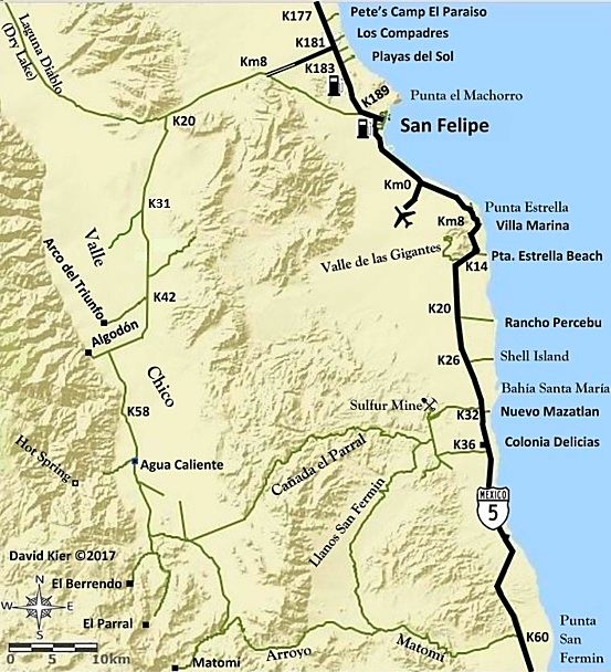
Yes Barry, it is there, along the base of the mountain... Now, a few cattle gates are across it and that requires a lot of opening and closing.
I last drove it from Algodon north to Diablo Dry Lake in 2004 when Nomad 'jide' and I explored the canyons from Parral north to Cajon.
Here, I just made this to show the old road on the west side of the valley. Algodón is at the lower left corner and Diablo Dry Lake is at the top...
EDIT: Thanks to your question, Barry... I found a mistake to fix! The road I showed as Km. 31 (El Cajon) is not! That will be resolved right away!
THIS IS (a good reason) WHY I SHARE MY WORK HERE...

OK, here is the corrected San Felipe Area Map:
[Edited on 12-21-2017 by David K]
|
|
|
PaulW
Ultra Nomad
Posts: 3005
Registered: 5-21-2013
Member Is Offline
|
|
As mentioned the west valley road is still in use. The north end before L Diablo is fenced and there is a go around slightly to the east then in into
the lake bed. I probably drive that road multiple times each winter season. The old road has some new jogs around to avoid a couple of ranchos. We
try to avoid the ranchos and all the cows.
Davids picture 2nd one up is pretty close, but without some of the detours I mentioned.
Meanwhile we have lost direct access to the canyon mouths south of Dilabito
From Dilabito going north one has to jog all the way east to the lake bed then north. Otherwise back track to El Cajon crossover road.
[Edited on 12-21-2017 by PaulW]
[Edited on 12-21-2017 by PaulW]
|
|
|
David K
Honored Nomad
Posts: 64479
Registered: 8-30-2002
Location: San Diego County
Member Is Offline
Mood: Have Baja Fever
|
|
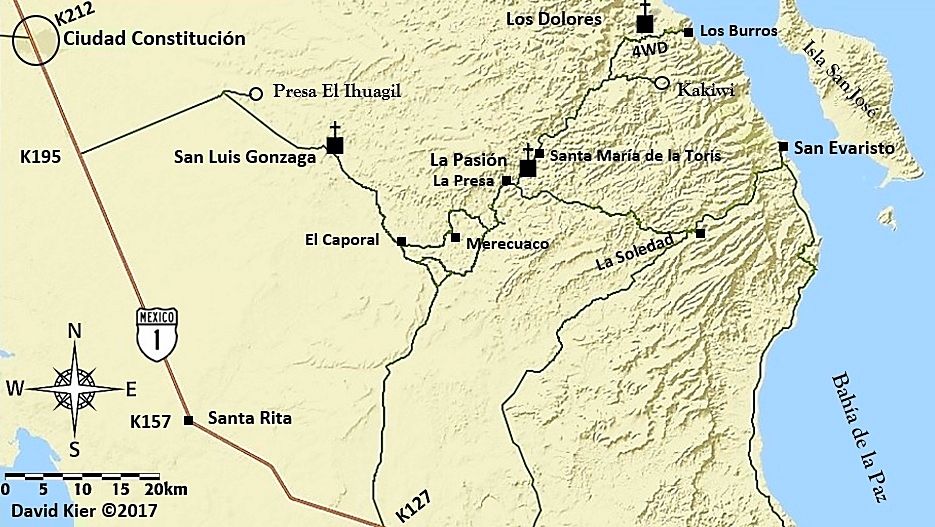
Merry Christmas
I just redid the Dolores area map (Cd. Constitución to San Evaristo):
After Christmas, I will be getting back to work on them.
[Edited on 12-25-2017 by David K]
|
|
|
David K
Honored Nomad
Posts: 64479
Registered: 8-30-2002
Location: San Diego County
Member Is Offline
Mood: Have Baja Fever
|
|
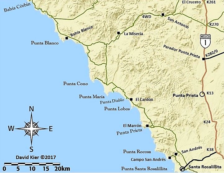
Back to work! South (7) Sisters Map
|
|
|
David K
Honored Nomad
Posts: 64479
Registered: 8-30-2002
Location: San Diego County
Member Is Offline
Mood: Have Baja Fever
|
|
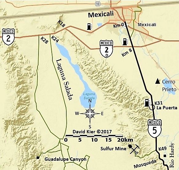
Before moving into Baja Sur, I needed to cover the Mexicali-San Felipe area a bit. Here is one of two maps (at least for the Hwy. 5 corridor and
Laguna Salada roads that are mentioned in the future guide.
This is the first draft... I may be adding to it or adjusting what I put on it...
|
|
|
David K
Honored Nomad
Posts: 64479
Registered: 8-30-2002
Location: San Diego County
Member Is Offline
Mood: Have Baja Fever
|
|
Today's work... just south of the previous. I think that's all I have for Baja Norte, at this time. Next... on to Baja Sur!

|
|
|
David K
Honored Nomad
Posts: 64479
Registered: 8-30-2002
Location: San Diego County
Member Is Offline
Mood: Have Baja Fever
|
|
I started a new thread for the Baja California Sur maps, that I began making today: http://forums.bajanomad.com/viewthread.php?tid=88595
I may make a thread as I touch up the Baja Norte maps, most have been shown in this thread, which I originally made to learn how to make the maps I
wanted. Thank you!
The new thread with the 25 first edition of these maps is posted on the Road Conditions forum: http://forums.bajanomad.com/viewthread.php?tid=88771
[Edited on 1-9-2018 by David K]
|
|
|
| Pages:
1
2
3
4 |


