Fatboy
Senior Nomad

Posts: 716
Registered: 6-28-2005
Member Is Offline
|
|
Questions from recent Rock-Pile hunt.
Spent 5 days hiking and camping in the area between Cerro Borrego and Arroyo Grande last week.
Hiked about 30 miles in the 5 days I was there and while there was no sign of the rock pile I did come across a couple of things that made wonder what
they were all about.
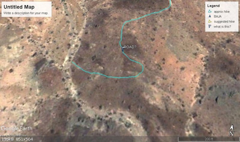
One was this lightly used road to nowhere. You can barely see it on google earth but it is clear from the hills across the creekbed and it looks like
it was made with a dozer and then never used.
First image is a google earth screen shot with just a placemarker on the road, while I roughly traced it on the second google earth image.
Also it seems google earth pro does screen shot different without the Coordinates on the page so here they are for the road....
31°27'58.43"N 115°18'37.62"W
|
|
|
Fatboy
Senior Nomad
Posts: 716
Registered: 6-28-2005
Member Is Offline
|
|
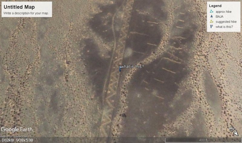
The second spot is here....
31°23'43.09"N 115°20'9.70"W
|
|
|
micah202
Super Nomad
Posts: 1615
Registered: 1-19-2011
Location: vancouver,BC
Member Is Offline
|
|
.
...that 2nd one is darn interesting by any measure,,, were you close to it? I'd be curious how there remains a distinctive pattern... for how long?
...without wear and weather obliterating it in parts. 
https://goo.gl/maps/pVDW9L9pGt72
[Edited on 11-16-2017 by BajaNomad]
|
|
|
TMW
Select Nomad
Posts: 10659
Registered: 9-1-2003
Location: Bakersfield, CA
Member Is Offline
|
|
The second spot is a run way that the government has trenched to prevent planes from landing. The area has been used by SCORE on a couple of the SF250
races.
|
|
|
Fatboy
Senior Nomad
Posts: 716
Registered: 6-28-2005
Member Is Offline
|
|
Quote: Originally posted by TMW  | | The second spot is a run way that the government has trenched to prevent planes from landing. The area has been used by SCORE on a couple of the SF250
races. |
Afraid it was going to be something boring like that.
The odd thing is the method they used to it. I will go to that actual spot this upcoming week.
The road in the first two is hard to see and seems to go no where and in a pretty remote spot.
|
|
|
Barry A.
Select Nomad
Posts: 10007
Registered: 11-30-2003
Location: Redding, Northern CA
Member Is Offline
Mood: optimistic
|
|
Does the faint road bypass some obstacle that was in the nearby large wash, perhaps?
|
|
|
David K
Honored Nomad
Posts: 64490
Registered: 8-30-2002
Location: San Diego County
Member Is Offline
Mood: Have Baja Fever
|
|
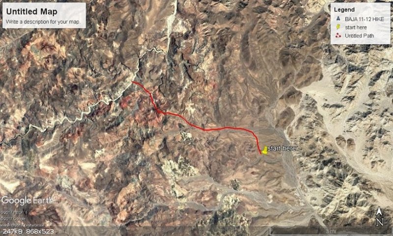
Can you show a high view of the track you hiked? Thanks for your interest in this mystery from the 1930s!
|
|
|
Fatboy
Senior Nomad
Posts: 716
Registered: 6-28-2005
Member Is Offline
|
|
The odd part of that faint roads is that it seems to end there in the wash, I did not walk the mesa top portion so not sure where it goes up on top
but I cannot see anything on google earth.
The bottom wash where it ends(?) would be a dead end, there appears to be no other way to get out of the wash in a vehicle except where the road is.
So the road seems to come from no where and then down into the wash and ends there.
|
|
|
Fatboy
Senior Nomad
Posts: 716
Registered: 6-28-2005
Member Is Offline
|
|
OK, not sure if this works.... Here are the KMZ google earth files for the hikes.
If it works, then the 3 labeled APPROX... are not actual tracks due to the fact that I either did not carry the gps on that hike, or I forgot to save
it afterwards.
Attachment: approx hike 2.kmz (7kB)
This file has been downloaded 212 times
Attachment: Approx hike part 1.kmz (4kB)
This file has been downloaded 170 times
Attachment: approx hike part 2.kmz (8kB)
This file has been downloaded 188 times
Attachment: BAJA 11-12 HIKE part 1.kmz (21kB)
This file has been downloaded 190 times
Attachment: BAJA 11-12 HIKE.kmz (55kB)
This file has been downloaded 174 times
Attachment: BAJA 11-13 HIKE OUT.kmz (22kB)
This file has been downloaded 176 times
Attachment: BAJA 11-13 HIKE IN.kmz (29kB)
This file has been downloaded 193 times
|
|
|
Fatboy
Senior Nomad
Posts: 716
Registered: 6-28-2005
Member Is Offline
|
|
hmmmm that seems to work so here are the KMZ Google earth files from my hikes in April
Attachment: h1.kmz (13kB)
This file has been downloaded 196 times
Attachment: h2.kmz (42kB)
This file has been downloaded 168 times
Attachment: h3.kmz (20kB)
This file has been downloaded 240 times
Attachment: h4.kmz (14kB)
This file has been downloaded 182 times
[Edited on 11-16-2017 by Fatboy]
Attachment: h5 guess.kmz (4kB)
This file has been downloaded 187 times
Attachment: h6.kmz (18kB)
This file has been downloaded 185 times
Attachment: h7.kmz (41kB)
This file has been downloaded 178 times
|
|
|
David K
Honored Nomad
Posts: 64490
Registered: 8-30-2002
Location: San Diego County
Member Is Offline
Mood: Have Baja Fever
|
|
Thank you.
Where your hike lines begin, was that from a point you could drive to?
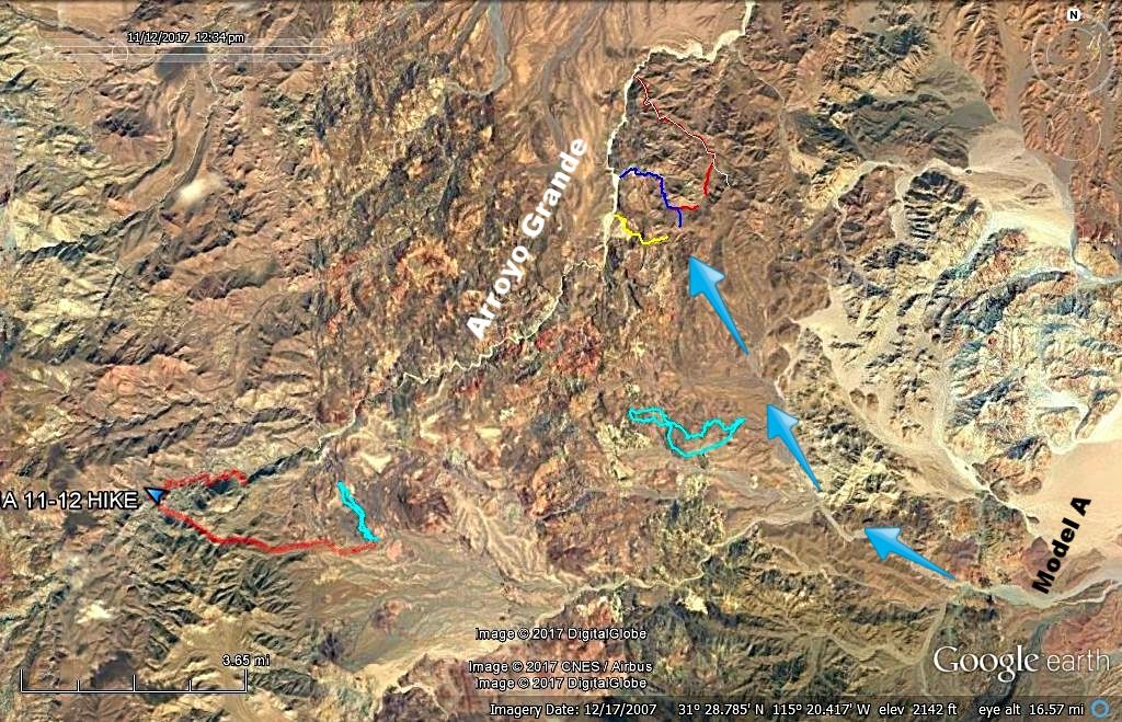
I added your tracks to this map that I have shown my original idea of where the Model A was parked and blue arrows of my idea of where Walter and
friend hiked on Day 1. The thin colored lines (north part of the map) are my idea of possible arroyos leading down to Arroyo Grande where Henderson
camped. It was on Day 1, going down the west-flowing arroyo that he found the 'rock pile'. We have searched the Arroyo Grande end of a few such
arroyos and all seemed impossible to hike, as there were dry waterfalls or such preventing easy travel. By all means, no Spanish soldiers on horseback
traveled them taking Melchior's body!
Again, I was trying to follow Walter's directions carefully in that he hiked all morning to reach the divide of the Sierra Pinta. He then went steeply
down the west flowing ravine into Arroyo Grande. 1/4 to 1/3 down from the divide, in the west flowing ravine, was a knob of level land where the
rock-pile was erected. He hiked on Day 2 up the arroyo and then returned to the Model A from the base of Borrego Mountain. You recent hikes may
represent his return voyage route to the Model A?
Walter told Choral Pepper if she were flying north-northeast from Borrego Mountain (towards today's gold mine by Hwy. 5) that she should (begin to?)
look down about 5 miles north of Borrego (Arrajal) to the west flowing canyons of the Sierra Pinta. He felt that knob and rock pile should be easy to
spot.
Happy hunting amigos... Take LOT's of photos if you find it!
|
|
|
bajaric
Senior Nomad
Posts: 604
Registered: 2-2-2015
Member Is Offline
|
|
Wow. that is a remote area where few people have trekked, that is, who have lived to tell the tale -- ha ha
My guess would be that it may be an old road that lead to a mine or prospect. The connecting road would have followed the arroyos towards the east
and long since been washed out. Did you hike up to the top? The links connect to google maps and worked for me but then when I tried to close it
wanted to save to a special google file, they keep track, you know...
On the topic of Diaz, I was reading an excellent book called California an Illustrated History by T.H. Watkins which is an large picture coffee table
type book, and it said he was killed (After crossing the Colorado River and traveling in the area south of the Salton Sink) when impaled on his lance
when attempting to spear a rabbit, as they were subsisting on foraged food on the journey back towards San Miguel de Culican.
OK so on the same topic of strange phenomenon seen from above, when looking at satellite images a couple of time I have seen an area of parallel
trenches, about 20 - 30 feet apart. I have seen this to the north of the Ronoso area and also to the south of El Alamo, anyone have an idea what
these are? I'm thinking drip irrigation oh well never mind don't want to go there --

[Edited on 11-16-2017 by bajaric]
|
|
|
David K
Honored Nomad
Posts: 64490
Registered: 8-30-2002
Location: San Diego County
Member Is Offline
Mood: Have Baja Fever
|
|
Early American writers were unaware of the boiling mud pots south of Mexicali (Cerro Prieto), it would seem? They only knew of the ones by the Salton
Sea, so they put Diaz that far north.
In either case, it still gives him the fame for being the first Spaniard to walk to California vs. arriving by ship from Mexico.
When Captain Diaz read the letter from Alarcón days before (left in a bottle) in the Colorado Delta or lower river, it released Diaz from his first
duty, to supply or join ship's crew in support of Coronado. Now, Melchior Diaz was free to explore the west side of the river.
Soon after the encounter with the volcanic lake of boiling mud, Melchior was annoyed by a dog chasing the sheep brought along on the voyage and threw
his lance, missing the dog. His horse threw the captain or couldn't be stopped before he fell upon the lance, piercing his body.
This is where the two versions of the story split. One version says his troop took him back across the river where he died somewhere in Sonora. The
other says his troop continued south in hopes of finding Alarcón's ships (taking on fresh water at San Felipe, perhaps?).
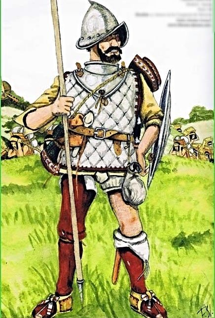
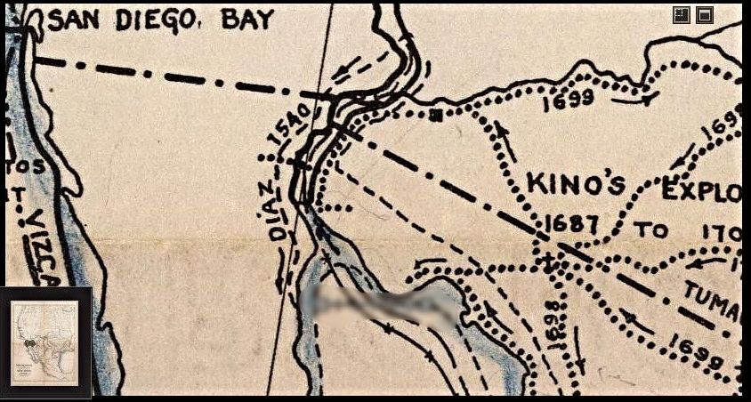
DIAZ 1540-1541 Voyage
|
|
|
yumawill
Nomad
Posts: 103
Registered: 10-11-2016
Member Is Offline
|
|
You fool! You're standing on the runway. How are the Ailens going to land with you there?
|
|
|
Fatboy
Senior Nomad
Posts: 716
Registered: 6-28-2005
Member Is Offline
|
|
| Quote: Originally posted by David K | Thank you.
Where your hike lines begin, was that from a point you could drive to?
I added your tracks to this map that I have shown my original idea of where the Model A was parked and blue arrows of my idea of where Walter and
friend hiked on Day 1.
You recent hikes may represent his return voyage route to the Model A?
Take LOT's of photos if you find it! |
Yes, all my hikes started from camps that I drove to.
Your comment about their return path is intriguing.
I am heading down tomorrow and going to revisit some of those areas.
Problem is terrain, reviewing my gps tracks it seems that any straight line distance on a map is at least 30% longer in reality.
Also that area you believed he parked at and walked to Arroyo Grande is some of the roughest country.
So here is my possible hike area for the next couple of days.
Attachment: possible hike.kmz (2kB)
This file has been downloaded 159 times
|
|
|
David K
Honored Nomad
Posts: 64490
Registered: 8-30-2002
Location: San Diego County
Member Is Offline
Mood: Have Baja Fever
|
|
Perfect! I will be with you in spirit!
|
|
|


