| Pages:
1
2
3 |
leo_jb
Newbie
Posts: 19
Registered: 10-28-2015
Member Is Offline
|
|
San Ignacio to Mulege
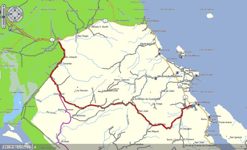
Taking a motorcycle trip to Baja in January with a few friends. We're all pretty decent riders with a fair amount of Baja experience, riding
relatively small dual-sport bikes. I'm trying to put together an alternate route between San Ignacio and Mulege. Pieced one together using my 2017
Cartographia E-32 map, but I know enough not to rely on the map in out-of-the-way places. Anyone have any experience with the attached route? Or a
recommended alternate?
|
|
|
David K
Honored Nomad

Posts: 64476
Registered: 8-30-2002
Location: San Diego County
Member Is Offline
Mood: Have Baja Fever
|
|
Please let us know how you do if you do go!
I was up at Mission Guadalupe, three months ago, and noted where that road meets the mission road. It was unsigned and only ranches nearby may use it.
It is just 1/2 mile from the Las Tunas & San Ignacio junction to the mission driveway. It should be seen if places built in 1720 interest you!
Here's more:https://www.bajabound.com/bajaadventures/bajatravel/mission_guadalupe.php
You might search Nomad for posts from 'TMW'. Here is a recent report on that road that goes via Rancho Las Tunas:
In May 2016: http://forums.bajanomad.com/viewthread.php?tid=83006
[Edited on 11-21-2017 by David K]
|
|
|
motoged
Elite Nomad
Posts: 6481
Registered: 7-31-2006
Location: Kamloops, BC
Member Is Offline
Mood: Gettin' Better
|
|
A bunch of us did it 6 years ago....take lots of water and travel light....there were some ridge passes consisting of grapefruit/ basketball-sized
rocks as well as flood ravaged arroyo roads that were wicked....
I say go for it....others will perhaps have more current intel...
DT Bushpilot and I were on 690's....next time I would take the 450....wouldn't touch it on a KLR or similar weight bike....
Good road up top (2011):


[Edited on 11-21-2017 by motoged]
Don't believe everything you think....
|
|
|
woody with a view
PITA Nomad
Posts: 15937
Registered: 11-8-2004
Location: Looking at the Coronado Islands
Member Is Offline
Mood: Everchangin'
|
|
Where’s the basketball’s Ged?
|
|
|
motoged
Elite Nomad
Posts: 6481
Registered: 7-31-2006
Location: Kamloops, BC
Member Is Offline
Mood: Gettin' Better
|
|
Woody,
I said that was the "good" road... the killer pass came after the
pics above.... the killer pass came after the
pics above....
Too busy sweating and grunting on the hard parts....
It's not like fishing where you are lounging on a boat drinking beer and holding up some smelly fish you just caught by surprise thinking it was
having another snack....
Do you have pics of the gnarliest wave you caught????
Huh....do ya????? 
Don't believe everything you think....
|
|
|
Desertbull
Senior Nomad
Posts: 558
Registered: 8-27-2003
Member Is Offline
|
|
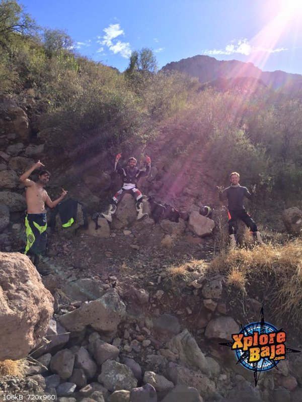
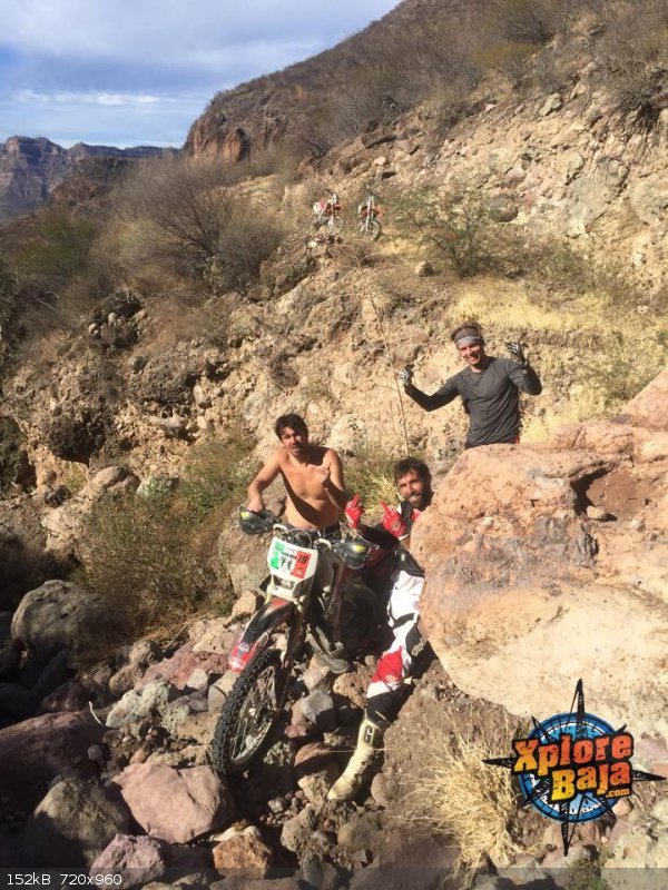
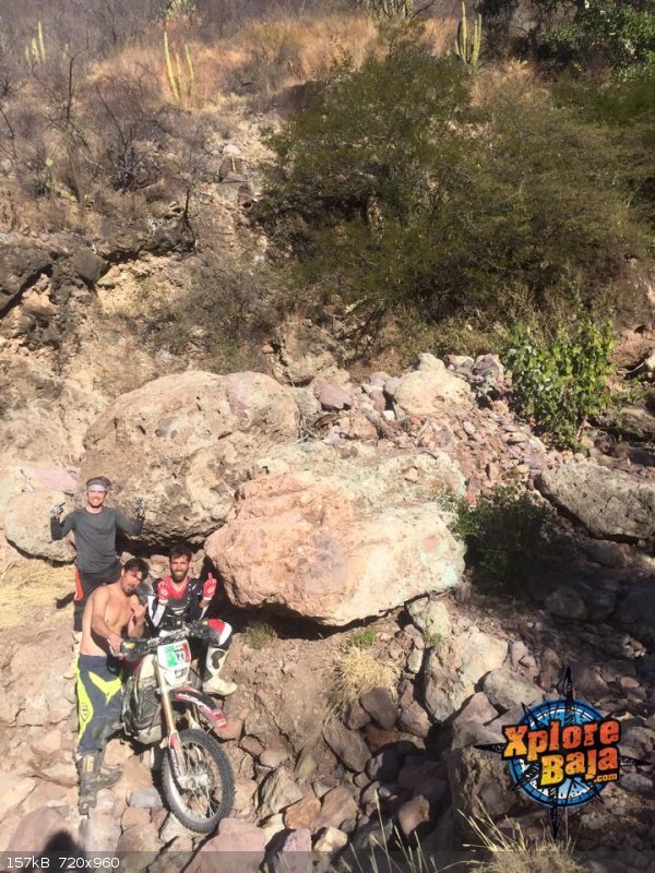
We did it last January but from San Juanico-Ballena Rd towards Mulege and left DOWNHILL route near Mision Guadelupe ... 15 hours for 4 A riders in top
physical condition on 450's ... the trail is not just gone but massive size boulders have come off the mountain and blocked several different canyons
.. a lot of hike-a-moto and building some rock bridges to push motos across ... gnarly to say the least. We had the chase truck move from Mision
Guadelupe turn and go to the other side at El Patrocinio and we still beat them there ... got to El Patracinio at 10 pm and onto San Ignacio. 
DREAM IT! PLAN IT! LIVE IT!
|
|
|
mtgoat666
Select Nomad
Posts: 17282
Registered: 9-16-2006
Location: San Diego
Member Is Offline
Mood: Hot n spicy
|
|
Quote: Originally posted by Desertbull  | We did it last January but from San Juanico-Ballena Rd towards Mulege and left DOWNHILL route near Mision Guadelupe ... 15 hours for 4 A riders in top
physical condition on 450's ... the trail is not just gone but massive size boulders have come off the mountain and blocked several different canyons
.. a lot of hike-a-moto and building some rock bridges to push motos across ... gnarly to say the least. We had the chase truck move from Mision
Guadelupe turn and go to the other side at El Patrocinio and we still beat them there ... got to El Patracinio at 10 pm and onto San Ignacio.
|
Every picture is you guys flipping the bird.
Classy!
Thank you for confirming our prejudices about knuckledraggers
Woke!
“...ask not what your country can do for you – ask what you can do for your country.” “My fellow citizens of the world: ask not what America
will do for you, but what together we can do for the freedom of man.”
Prefered gender pronoun: the royal we
|
|
|
TMW
Select Nomad
Posts: 10659
Registered: 9-1-2003
Location: Bakersfield, CA
Member Is Offline
|
|
I had originally put together a route based on info that BajaBlanca got from the rancher at Las Tunas just west of the Mission Guadalupe ruins.
According to the rancher only horses could get thru from his ranch to where the road is good.
Having said that, Cameron Steele has went thru on one of his motorcycle rides to Cabo, the one where the bikes fell out of the boat into the sea at
Mulege. Also Desert Bull ran chase for 3 or 4 motorcycle guys a couple of years ago and posted some pictures here on Nomads where they got thru,
pretty rough. They went thru at Rancho San Juan de la Pila and I believe the really rough part was from La Pila to Rancho San Marcos where they had to
carry the bikes over rocks.
The route I wanted to follow went down to El Patrocino then east picking up BajaBlancas route at Los Patos and Santa Ana as shown on the almanac.
I'll look thru and see what I have. John M also had the route by BajaBlanca traced on the almanac. He may be able to post it.
|
|
|
TMW
Select Nomad
Posts: 10659
Registered: 9-1-2003
Location: Bakersfield, CA
Member Is Offline
|
|
I see Desert Bull already posted his trip info, thanks Tim.
|
|
|
motoged
Elite Nomad
Posts: 6481
Registered: 7-31-2006
Location: Kamloops, BC
Member Is Offline
Mood: Gettin' Better
|
|
| Quote: Originally posted by mtgoat666 |
Every picture is you guys flipping the bird.
Classy!
Thank you for confirming our prejudices about knuckledraggers |
Goat,
Don't take the finger personally....unless it fits
....for the inner crowd, it is the ADVRider salute....
Don't believe everything you think....
|
|
|
TMW
Select Nomad
Posts: 10659
Registered: 9-1-2003
Location: Bakersfield, CA
Member Is Offline
|
|
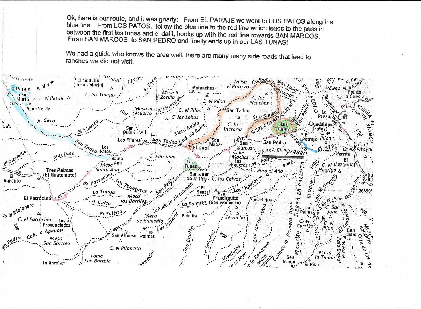
Here is the route that BajaBlanca took to Rancho Las Tunas in 2014.
Her description of the route is at the top. Note this route bypasses Rancho San Juan de la Pila. I think it would be easier to go to El Patrocino then
east and pick up her route. I believe they were visiting ranches as they went along and that is why they started where they did. She can better answer
that.
|
|
|
woody with a view
PITA Nomad
Posts: 15937
Registered: 11-8-2004
Location: Looking at the Coronado Islands
Member Is Offline
Mood: Everchangin'
|
|
Funny you should ask!
http://s1250.photobucket.com/user/MasOlas/media/Salsi312-10-...
|
|
|
TMW
Select Nomad
Posts: 10659
Registered: 9-1-2003
Location: Bakersfield, CA
Member Is Offline
|
|
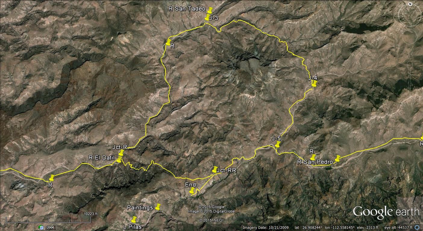
Here is a Google Earth image of the area she mentions of a pass. R. San Marcos would be somewhere between Jct RR and J-5.
[Edited on 11-21-2017 by TMW]
|
|
|
motoged
Elite Nomad
Posts: 6481
Registered: 7-31-2006
Location: Kamloops, BC
Member Is Offline
Mood: Gettin' Better
|
|
No pic....pay yer bills....
Don't believe everything you think....
|
|
|
woody with a view
PITA Nomad
Posts: 15937
Registered: 11-8-2004
Location: Looking at the Coronado Islands
Member Is Offline
Mood: Everchangin'
|
|
I’m the ant! Only guy in the water @ Salsipuedes 1983 or 84. The shark wouldnt bite and the bee wouldnt sting.

|
|
|
4x4abc
Ultra Nomad
Posts: 4163
Registered: 4-24-2009
Location: La Paz, BCS
Member Is Offline
Mood: happy - always
|
|
| Quote: Originally posted by TMW | Here is a Google Earth image of the area she mentions of a pass. R. San Marcos would be somewhere between Jct RR and J-5.
[Edited on 11-21-2017 by TMW] |
Tom,
what you have marked as San Pedro is actually San marcos
Harald Pietschmann
|
|
|
BajaBlanca
Select Nomad
Posts: 13165
Registered: 10-28-2008
Location: La Bocana, BCS
Member Is Offline
|
|
Desertbull -those pics make my stomach turn! Those are some nasty boulders.
Our trip was amazing and scary and if you want a guide, my student Alexis with his family is heading out there sometime like Dec. 20th - one day
after my xmas party for the college scholarship kids which he is coming to.
|
|
|
BajaBlanca
Select Nomad
Posts: 13165
Registered: 10-28-2008
Location: La Bocana, BCS
Member Is Offline
|
|
Alexis's family lives at Las Tunas, the last or almost last rancho.
|
|
|
David K
Honored Nomad
Posts: 64476
Registered: 8-30-2002
Location: San Diego County
Member Is Offline
Mood: Have Baja Fever
|
|
The boulders in Tim's photos is the road between Guadalupe and San José de Magdalena. That was the 'good' road to the mission before the storms of
2014 or so took it out.
|
|
|
TMW
Select Nomad
Posts: 10659
Registered: 9-1-2003
Location: Bakersfield, CA
Member Is Offline
|
|
| Quote: Originally posted by 4x4abc | | Quote: Originally posted by TMW | Here is a Google Earth image of the area she mentions of a pass. R. San Marcos would be somewhere between Jct RR and J-5.
[Edited on 11-21-2017 by TMW] |
Tom,
what you have marked as San Pedro is actually San marcos |
Thanks Harald, when I did that image I think I was following the almanac and GE and trying to match the ranches along the way. I would like to do that
route just to see it and what the bad area past R. Las Tunas looks like now.
Three or four years ago Rudy and a few of us went to San Juan de la Pila and stayed the night. The couple there were very friendly and the man took us
to see the paintings in two locations. He said there was more to see but we were limited in time. The road past their place was wiped out a couple of
years before we went there.
|
|
|
| Pages:
1
2
3 |


