| Pages:
1
2
3 |
MulegeAL
Nomad

Posts: 298
Registered: 8-25-2009
Location: PDX/Mulege
Member Is Offline
|
|
I hope to check out the "southerly" route east from El Datil this winter.
Will update assuming I come back alive. May need a co-rider, not really any one else here in Mulege crazy enough to go try these blown out pasos
anymore, 'cept me.
|
|
|
BajaBlanca
Select Nomad
Posts: 13165
Registered: 10-28-2008
Location: La Bocana, BCS
Member Is Offline
|
|
Go with Alexis and his family. If you want to coordinate, I can get details on when they are heading over. I am pretty sure it will be the 20th
Dec. or next day.
|
|
|
Desertbull
Senior Nomad
Posts: 558
Registered: 8-27-2003
Member Is Offline
|
|
Ya Baja Blanca, we used to drive trucks through all those roads before that massive storm wiped it all out, we always brought goodies (food, drinks,
tools, leather, kitchen utensils, etc. for the ranches, I've had some of my most amazing nights camped with families sharing everything we had in our
trucks with them. Truly the most amazing people I've met are the families in the backcountry. luv luv luv
DREAM IT! PLAN IT! LIVE IT!
|
|
|
David K
Honored Nomad
Posts: 64476
Registered: 8-30-2002
Location: San Diego County
Member Is Offline
Mood: Have Baja Fever
|
|
Quote: Originally posted by Desertbull  | Ya Baja Blanca, we used to drive trucks through all those roads before that massive storm wiped it all out, we always brought goodies (food, drinks,
tools, leather, kitchen utensils, etc. for the ranches, I've had some of my most amazing nights camped with families sharing everything we had in our
trucks with them. Truly the most amazing people I've met are the families in the backcountry. luv luv luv
|
So very cool!
|
|
|
PaulW
Ultra Nomad
Posts: 3005
Registered: 5-21-2013
Member Is Offline
|
|
Yup. Back in the day we drove an F350 with camper following that general route. Even then it was a very big deal. Barely passable. Had a nice visit
with a local rancher along the way.
|
|
|
motoged
Elite Nomad
Posts: 6481
Registered: 7-31-2006
Location: Kamloops, BC
Member Is Offline
Mood: Gettin' Better
|
|
| Quote: Originally posted by MulegeAL | I hope to check out the "southerly" route east from El Datil this winter.
Will update assuming I come back alive. May need a co-rider, not really any one else here in Mulege crazy enough to go try these blown out pasos
anymore, 'cept me. |
Hola, Al....
I am weathering the frozen wastelands up north this winter....but hope to be down next year with my 450 for several months....Dec-Feb.
If you survive your scouting this year, I would do some exploring with you....
Day rides or a loop? 
Don't believe everything you think....
|
|
|
MulegeAL
Nomad
Posts: 298
Registered: 8-25-2009
Location: PDX/Mulege
Member Is Offline
|
|
BB, thanks for the info, it will be decided by the calendar next month as I'm pretty sure I'll be crossing back in on the 16th or 17th with a big slow
load in tow. But my moto stuff is staged and ready: lube thy chain, load and go.
Given schedule, timing, communication hassles, may be best for me to try east to west over the pass at mission guadelupe, I haven't done that climb
for a couple of hurricanes, roll a few rocks out of the way. And meet up there somewhere, double back to Mulege. I think the worst of it is east of
El Datil, was really tough to ride through there. Locals stopped driving the pass road after storm Paul, I only see mule/burro tracks now.
September storm did the area no favors whatsoever, some ranchers just N/NE of there are bailing because the roads are so bad, gas mucho pesos, hard to
make a living, kids don't want to live there when they grow up, etc.
Ged,
I thought global warming had eased your situation by now! Bring a light bike with sticky tires for our blown out paso punishment rides down here!
|
|
|
captain.olives
Newbie
Posts: 24
Registered: 11-13-2009
Location: NorCal
Member Is Offline
|
|
Thanks Bajabull, Bajablanca and everyone else for the great info. Leo, I am sure you are thinking the same as I right now. If it took some young A
guys on 450s as long as it did to make it through, I think we should route even our younger fast guys down through Arroyo San Raymundo. I know I am
not attempting that with bags strapped to my bike if I have to ride the rest of the week.
There is fun and a challenge, then there is trip killing energy drain days even if we could make it before dark (doubtful as we are older and moving
slower than young guys like BajaBull). Maybe we head up to San Marcos from Mulege on the rest day to check it out.
Are any of the paths SE of El Patrocino rideable all the way to San Jose de Gracia? Thinking of alternative fun routes for average experienced riders
From San Ignacio over the mesas to Arroyo San Raymundo (La Balena - Muluge route). Something more challenging than the high road to Scorpion Bay.
Al and others, come have a beer or two with us in Mulege. Just walk up to anyone and tell them CJ said you would buy me a beer. Thanks for everyones
input thus far.
|
|
|
TMW
Select Nomad
Posts: 10659
Registered: 9-1-2003
Location: Bakersfield, CA
Member Is Offline
|
|
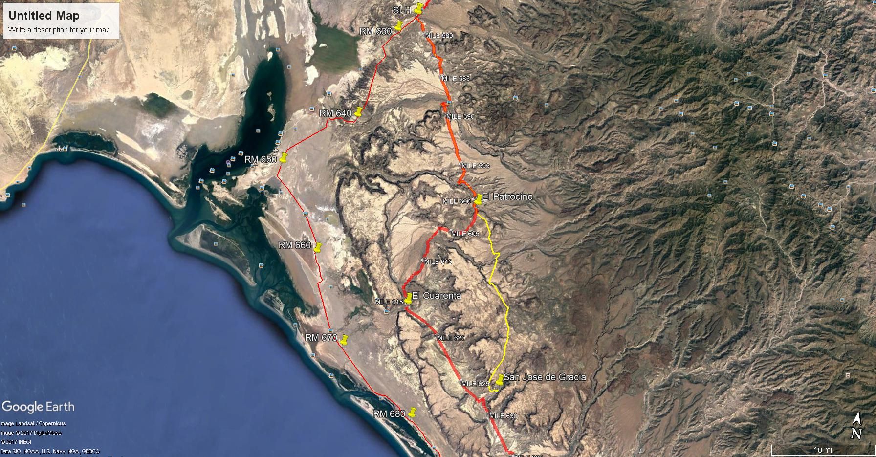
In 2010 and 2012 during the Baja 1000 SCORE ran a section from just north of El Patrocino to Rancho El Cuarenta. I ran it in my GMC and I think it
follows along Arroyo el Quemado as shown in the almanac.
Here is a Google Earth image with the 2017 1000 on the left and the 2010 1000 in the middle. The right yellow line is a route I traced on GE from San
Jose de Gracia to El Patrocino and on to the hwy.
|
|
|
motoged
Elite Nomad
Posts: 6481
Registered: 7-31-2006
Location: Kamloops, BC
Member Is Offline
Mood: Gettin' Better
|
|
| Quote: Originally posted by MulegeAL |
.......
Ged,
I thought global warming had eased your situation by now! Bring a light bike with sticky tires for our blown out paso punishment rides down here!
|
Al,
I use double-sided Gorilla tape for back tire for Guadalupe Canyon type terrain.....will you have your drone pilot along to make sure the events are
kept for posterity
Global warming just hit here today....11' C. here today....so I am out on the 690 for a ride before the second wave of snowstorms are upon us.....the
Pineapple Express is bringing Hawaiian warmth and moisture up this way....
Have a Stinky Burger for me at El Candil.....and say hello to Richard (Willy Airstream) when you can.
Don't believe everything you think....
|
|
|
MulegeAL
Nomad
Posts: 298
Registered: 8-25-2009
Location: PDX/Mulege
Member Is Offline
|
|
CaptO, sounds good! La Ballena east to Mulege is still there, expect 30+ miles of rock and sand on the west end, and water in the vados. From
therein is just bad road.
I may get only one chance to scam my drone driver into the mission area, doubtful for the drop in to the blown out pass towards San Jose de M. That
has become a real tough out, with 50/50 chance of back!
[Edited on 11-23-2017 by MulegeAL]
|
|
|
leo_jb
Newbie
Posts: 19
Registered: 10-28-2015
Member Is Offline
|
|
| Quote: Originally posted by BajaBlanca | | Go with Alexis and his family. If you want to coordinate, I can get details on when they are heading over. I am pretty sure it will be the 20th
Dec. or next day. |
When are you planning on this? We will be riding the week of January 28.
|
|
|
leo_jb
Newbie
Posts: 19
Registered: 10-28-2015
Member Is Offline
|
|
| Quote: Originally posted by MulegeAL | CaptO, sounds good! La Ballena east to Mulege is still there, expect 30+ miles of rock and sand on the west end, and water in the vados. From
therein is just bad road.
I may get only one chance to scam my drone driver into the mission area, doubtful for the drop in to the blown out pass towards San Jose de M. That
has become a real tough out, with 50/50 chance of back!
[Edited on 11-23-2017 by MulegeAL] |
Sounds like this is the route you are referring to (lower route in magenta)? You think it is still doable?
[Edited on 11-24-2017 by leo_jb]
|
|
|
leo_jb
Newbie
Posts: 19
Registered: 10-28-2015
Member Is Offline
|
|
Belay that. Just realized that is more or less our "usual" route from Mulege to Scorpion Bay.
|
|
|
leo_jb
Newbie
Posts: 19
Registered: 10-28-2015
Member Is Offline
|
|
| Quote: Originally posted by Desertbull | We did it last January but from San Juanico-Ballena Rd towards Mulege and left DOWNHILL route near Mision Guadelupe ... 15 hours for 4 A riders in top
physical condition on 450's ... the trail is not just gone but massive size boulders have come off the mountain and blocked several different canyons
.. a lot of hike-a-moto and building some rock bridges to push motos across ... gnarly to say the least. We had the chase truck move from Mision
Guadelupe turn and go to the other side at El Patrocinio and we still beat them there ... got to El Patracinio at 10 pm and onto San Ignacio. 
|
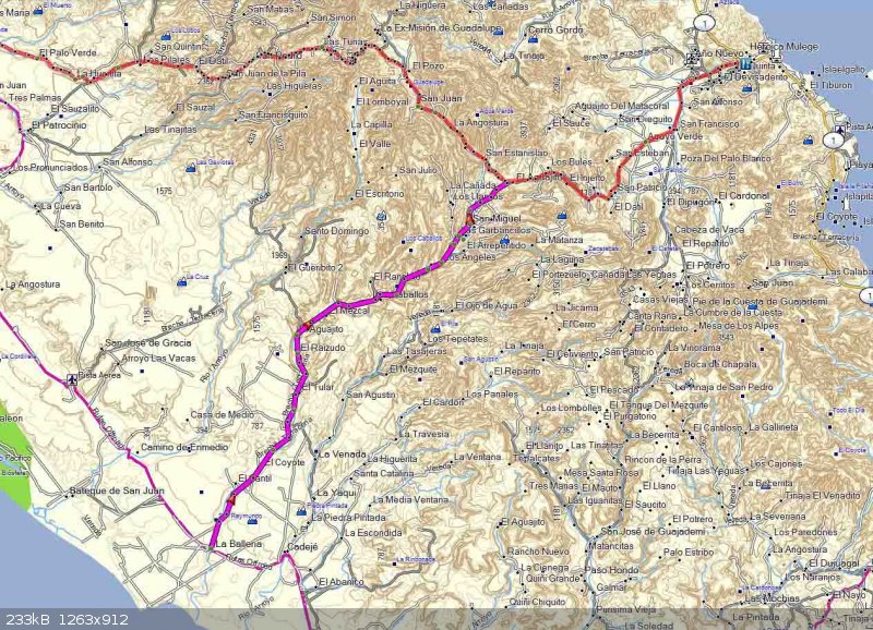
DesertBull - sounds like I wouldn't want to retrace your route, but I can't figure out which way you went. Did you head north at Aguajito and try to
connect around San juan de la Pila? E32 doesn't even show that road going through (Green route on attached)

|
|
|
MulegeAL
Nomad
Posts: 298
Registered: 8-25-2009
Location: PDX/Mulege
Member Is Offline
|
|
leo, correcto mundo on usual route, is OK.
PS: I tried to connect south from El Datil area to your green line route in '04 (5 or 6 hurricanes ago) and it was no go.
I think the only fighting chance is through El Datil, the box canyon above it, and whatever lies beyond that DesertBull hammered through on. Needs
more daylight than December allows up there.
And I just want to add: motos make possible trips into these places and spaces that are next to impossible with any other form of mechanized travel.
It is not just the rugged challenging terrain that attracts, it is the amazing people who live in these remote areas, who are so generous with what
little they have, and have been so good and friendly towards me and my travelling pals.
It is a vanishing way of life that I am lucky to be a small transient part of of. It is those amazing people that motivate me to return to these very
remote ranchos, where almost nobody speaks any English, yet we seem to get along fine.
And that is why I will keep busting my butt to get in there, even if its for a short while, though I have seen them almost in tears when I said I must
return to town and cannot stay the night. Remotest baja is still amazing, for a while longer.
[Edited on 11-25-2017 by MulegeAL]
|
|
|
Tomas Tierra
Super Nomad
Posts: 1281
Registered: 3-23-2005
Location: oxnard, ca
Member Is Offline
Mood: Tengo Flojera
|
|
| Quote: Originally posted by Desertbull | Ya Baja Blanca, we used to drive trucks through all those roads before that massive storm wiped it all out, we always brought goodies (food, drinks,
tools, leather, kitchen utensils, etc. for the ranches, I've had some of my most amazing nights camped with families sharing everything we had in our
trucks with them. Truly the most amazing people I've met are the families in the backcountry. luv luv luv
|
Awesome!!!!!!!
|
|
|
David K
Honored Nomad
Posts: 64476
Registered: 8-30-2002
Location: San Diego County
Member Is Offline
Mood: Have Baja Fever
|
|
Bump for Dmitriy.
|
|
|
leo_jb
Newbie
Posts: 19
Registered: 10-28-2015
Member Is Offline
|
|
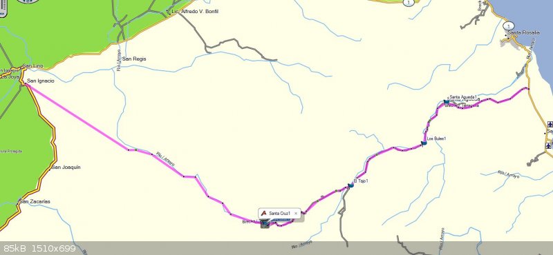
How about this one? SE out of San Ignacio to Santa Cruz, then NE through El Tajo and Los Brules to Hwy 1 just south of Santa Rosalia. Anyone have
any current knowledge about this route?
|
|
|
gueribo
Nomad
Posts: 458
Registered: 10-16-2014
Member Is Offline
|
|
I'm a bit late to the thread . . . curious if there have been any repairs to the road from San José de Magdalena to Mission Guadalupe. A friend will
be traveling down this spring and hopes to do (what we call) the "Guadalupe Loop" (Mulegé to San Estanislao to Ex-Mission Guadalupe to San José de
Magdalena and back to Hwy 1). Sounds like it may still be washed out.
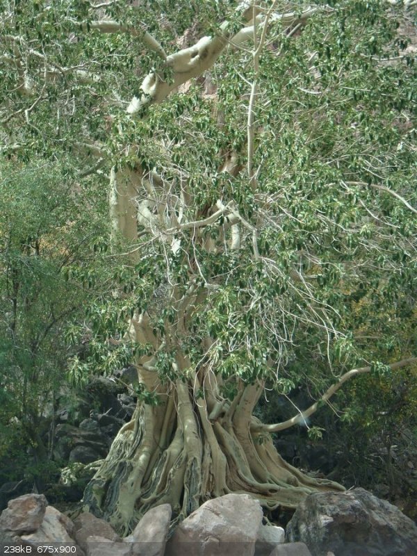
There are so many beautiful places in Baja, but that wild winding stretch between Mission Guadalupe and San José de Magdalena ranks among my
favorites. The terrain is rugged and beautiful--the canyons and wild fig...
|
|
|
| Pages:
1
2
3 |


