| Pages:
1
2 |
Proper
Newbie
Posts: 10
Registered: 11-30-2017
Member Is Offline
|
|
Trail Riding near Ensenada Dirt Bikes
Hello!
I'm in search of dirt biking trails near Ensenada or on the North Western side of Baja. My Girlfriend and I are planning our first trip to Baja and
are eager to get some riding in while we are there.
We're beginner/intermediate riders and will be bringing our bikes with us as opposed to riding down from SoCal.
Any ideas would be much appreciated! Looking forward to our first visit! 
|
|
|
ehall
Super Nomad

Posts: 1906
Registered: 3-29-2014
Location: Buckeye, Az
Member Is Offline
Mood: It's 5 o'clock somewhere
|
|
You would have better luck a little east of Tecate at Rancho Santa Veronica. Lots of trails start right at the hotel. Big race this weekend so trails
should be very easy to locate after that. Touchy area, don't trespass and please leave the gates as you found them. Probably be able to hook up with
some other riders also.
|
|
|
David K
Honored Nomad
Posts: 64478
Registered: 8-30-2002
Location: San Diego County
Member Is Offline
Mood: Have Baja Fever
|
|
Do you have a map or an idea of how far out you want to ride? Most roads in Baja are dirt roads.
Going east from Ensenada, explore roads off Hwy 3 to San Felipe and see gold mines, hot springs, pine forests...
Going south from Ensenada take roads west from Hwy 1 on the way to San Quintin and follow the Pacific Coast. Maybe stay at Coyote Cals near Ejido
Eréndira?
Need maps?
[Edited on 11-30-2017 by David K]
|
|
|
Proper
Newbie
Posts: 10
Registered: 11-30-2017
Member Is Offline
|
|
| Quote: |
You would have better luck a little east of Tecate at Rancho Santa Veronica. Lots of trails start right at the hotel. Big race this weekend so trails
should be very easy to locate after that. Touchy area, don't trespass and please leave the gates as you found them. Probably be able to hook up with
some other riders also.
|
Thanks Ehall. Any idea if it is okay to ride CA Green Sticker (non plated) bike in these areas legally?
|
|
|
Proper
Newbie
Posts: 10
Registered: 11-30-2017
Member Is Offline
|
|
Thanks for the reply David.
| Quote: |
Do you have a map or an idea of how far out you want to ride? Most roads in Baja are dirt roads.
|
We don't have maps yet. I'm hoping to find this info on this forum 
| Quote: |
Going east from Ensenada, explore roads off Hwy 3 to San Felipe and see gold mines, hot springs, pine forests...
|
This sounds incredible! We're used to riding trails in California with clear signage etc, so I'm a bit concerned about getting lost while exploring.
I'm very interested in any maps you can point to or other advice/info experienced riders of the area have.
Thank you
|
|
|
Proper
Newbie
Posts: 10
Registered: 11-30-2017
Member Is Offline
|
|
| Quote: |
how far out you want to ride?
|
We need to stick to rides that don't require oversized gas tanks, as our bikes are not equipped with that. Ideally, we'd like to be able to ride out
and back in a couple hours, though if there are places to get petrol along the way, a full day of riding isn't out of the question.
|
|
|
David K
Honored Nomad
Posts: 64478
Registered: 8-30-2002
Location: San Diego County
Member Is Offline
Mood: Have Baja Fever
|
|
OK, amigo... petrol is called gasolina in Mexico, unlike Spain.
Roads are not well signed... some are, but you do not rely on signs for navigation on dirt roads in Baja.
You must get a GPS device with Baja topo maps loaded on, there is just no question of that being what you want to do. There are a few different
choices here is one map that can be downloaded into a GPS: http://www.lbmaps.com/
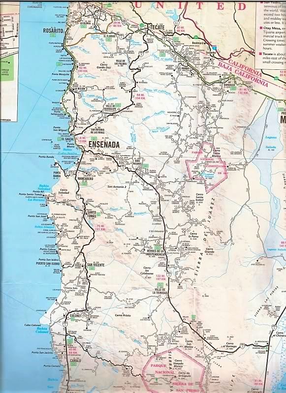
For a general visual of the road network out from Ensenada:
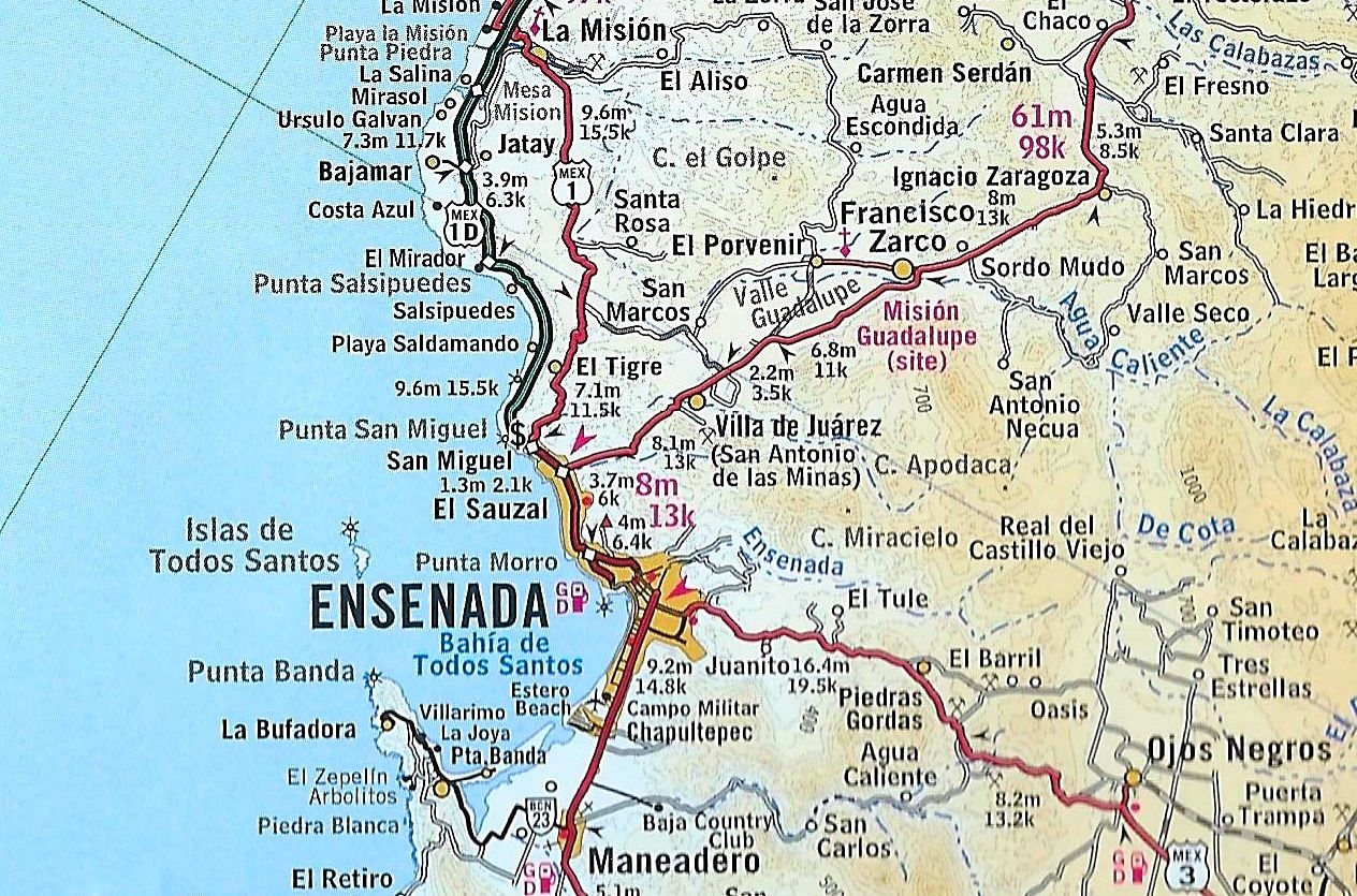
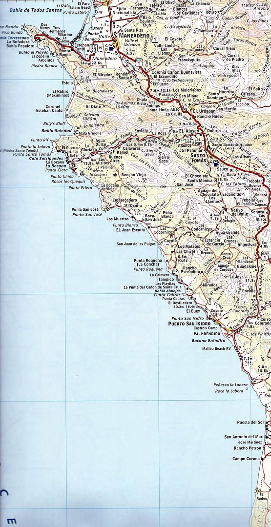
The 2010 Auto Club map is easy to use and has mileages along every road on the map... they just don't show all the roads...
Close up:
|
|
|
DanO
Super Nomad
Posts: 1923
Registered: 8-26-2003
Location: Not far from the Pacific
Member Is Offline
|
|
You will find no signage offroad, but you should have no issues getting lost if you just stick with the graded dirt roads shown on the maps David
posted. GPS is still a good idea and pretty cheap these days. Not sure what your fuel range is, but south of Ensenada the roads from Santo Tomas to
La Bocana or to Punta San Jose/Punta Cabras are fun and easy rides. Watch for oncoming vehicles, farm equipment, livestock, and dogs (some of them
love to chase bikes), and be careful around blind corners.
\"Without deviation from the norm, progress is not possible.\" -- Frank Zappa
|
|
|
Proper
Newbie
Posts: 10
Registered: 11-30-2017
Member Is Offline
|
|
David K, thanks for the info!
Where can we ride a non-plated dirt bike?
|
|
|
David K
Honored Nomad
Posts: 64478
Registered: 8-30-2002
Location: San Diego County
Member Is Offline
Mood: Have Baja Fever
|
|
Where-ever you want and not mess with locked gates.
Closed gates are okay to open (and reclose behind you) as they are for livestock control. Only if it is posted to keep out (No Hay Paso) are you not
welcome.
Driving to Mission Guadalupe (west of Mulegé), I had to open and close 4 gates... twice (going in and coming out).
|
|
|
Proper
Newbie
Posts: 10
Registered: 11-30-2017
Member Is Offline
|
|
| Quote: |
You will find no signage offroad, but you should have no issues getting lost if you just stick with the graded dirt roads shown on the maps David
posted. GPS is still a good idea and pretty cheap these days. Not sure what your fuel range is, but south of Ensenada the roads from Santo Tomas to La
Bocana or to Punta San Jose/Punta Cabras are fun and easy rides. Watch for oncoming vehicles, farm equipment, livestock, and dogs (some of them love
to chase bikes), and be careful around blind corners.
|
Thanks DanO. I appreciate the info. I have a stock 2 gallon tank. Will look into a GPS and get those maps. Any other recommendations are welcome.
|
|
|
JZ
Elite Nomad
Posts: 9225
Registered: 10-3-2003
Member Is Online
|
|
Yes, you can run a non-plated dirt bike. You need the registration when you cross. They will check it against your vin.
Run a GPS app on your phone. They have all the bigger dirt roads already and you can add custom ones you make from Google Earth or someone gives you.
Back Country Navigator is the best, but only works on Android. MotionX is very good and works on Apple.
I have hundreds of miles of Baja mapped out in central and Southern Baja that I can share, but not where you are talking. Most of them I hand created
by zooming into Google Earth. You should study the area you are going to ride on GE. Preferably with a large monitor.
I run Back Country Navigator on my phone and mount it on the handle bar. We just rode for 12 days from Loreto to La Paz. You want an app like this
for sure.
[Edited on 12-1-2017 by JZ]
|
|
|
JZ
Elite Nomad
Posts: 9225
Registered: 10-3-2003
Member Is Online
|
|
Here is the mount I use: https://www.amazon.com/gp/product/B01HUEZ7SS/ref=od_aui_deta...
|
|
|
bajatrailrider
Super Nomad
Posts: 2423
Registered: 1-24-2015
Location: Mexico
Member Is Offline
Mood: Happy
|
|
Coyote Cals South of Ensenada on the beach good trails and dirt roads.
|
|
|
Proper
Newbie
Posts: 10
Registered: 11-30-2017
Member Is Offline
|
|
| Quote: |
Yes, you can run a non-plated dirt bike. You need the registration when you cross. They will check it against your vin.
Run a GPS app on your phone. They have all the bigger dirt roads already and you can add custom ones you make from Google Earth or someone gives you.
Back Country Navigator is the best, but only works on Android. MotionX is very good and works on Apple.
I have hundreds of miles of Baja mapped out in central and Southern Baja that I can share, but not where you are talking. Most of them I hand created
by zooming into Google Earth. You should study the area you are going to ride on GE. Preferably with a large monitor.
I run Back Country Navigator on my phone and mount it on the handle bar. We just rode for 12 days from Loreto to La Paz. You want an app like this for
sure.
|
Thanks for all the info JZ!
|
|
|
Proper
Newbie
Posts: 10
Registered: 11-30-2017
Member Is Offline
|
|
Thanks for the recommendation!
|
|
|
bajaguy
Elite Nomad
Posts: 9247
Registered: 9-16-2003
Location: Carson City, NV/Ensenada - Baja Country Club
Member Is Offline
Mood: must be 5 O'clock somewhere in Baja
|
|
Insurance
If you don't have a SPOT, get one
https://www.findmespot.com/en/index.php?cid=100
|
|
|
JZ
Elite Nomad
Posts: 9225
Registered: 10-3-2003
Member Is Online
|
|
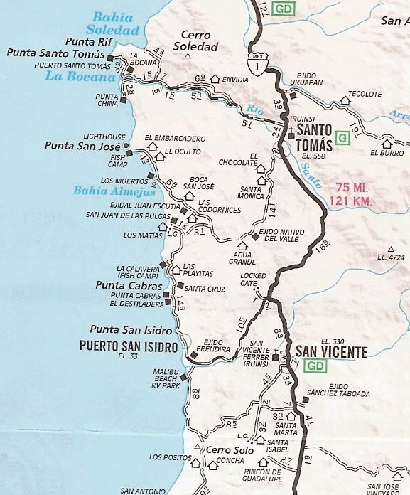
This is where I would suggest you go. Looks like beautiful riding along the coast.
@bajatrailrider, can you ride along the coast from Ensenada all the way to Cals? Looks like it on GE.
[Edited on 12-2-2017 by JZ]
|
|
|
bajatrailrider
Super Nomad
Posts: 2423
Registered: 1-24-2015
Location: Mexico
Member Is Offline
Mood: Happy
|
|
Quote: Originally posted by JZ  |
This is where I would suggest you go. Looks like beautiful riding along the coast.
@bajatrailrider, can you ride along the coast from Ensenada all the way to Cals? Looks like it on GE.
[Edited on 12-2-2017 by JZ] |
Only if you want to do missing link trail Expert only even then you may have to push bike JAAAAAA.
|
|
|
JZ
Elite Nomad
Posts: 9225
Registered: 10-3-2003
Member Is Online
|
|
Ok, I just read your September thread on that. Did you do the November ride?
Where can you jump down to the coast above Cals that avoids the really difficult stuff?
|
|
|
| Pages:
1
2 |