| Pages:
1
2 |
JZ
Elite Nomad

Posts: 9226
Registered: 10-3-2003
Member Is Offline
|
|
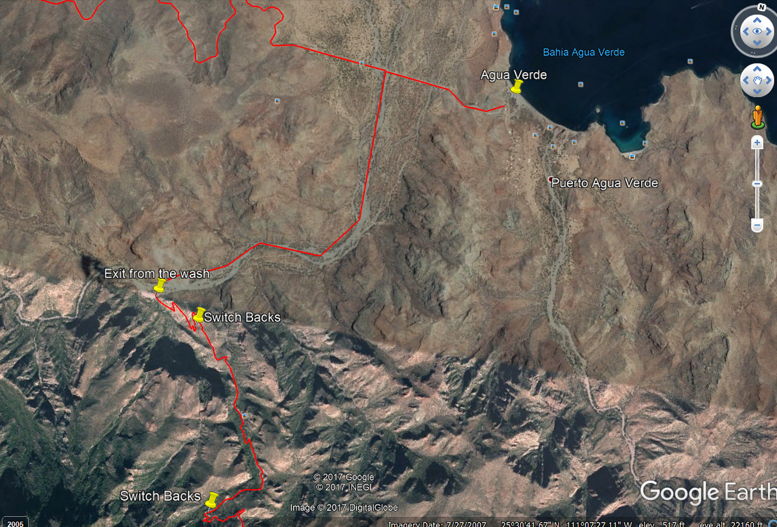
Can someone show me the route out of Agua Verde
That goes through the canyon? I think I have it mapped out once you hit the climb up and the switch backs. But no 100% sure on the first couple mile
out.
I see where the wash goes up. I gave it a short ride and it was really rocky. Could do it on a bike, but would be tough in a truck. So not sure
that's the right way?
[Edited on 12-4-2017 by JZ]
|
|
|
TMW
Select Nomad
Posts: 10659
Registered: 9-1-2003
Location: Bakersfield, CA
Member Is Offline
|
|
The turn off to the arroyo from the main road is at 25-30.94x111-05.09.
The road out of the wash and up the mountain is at
25-29.68x111-05.98. Once you start up the mountain the road is good to Constitucion. Great view at you go up the mtn.
|
|
|
JZ
Elite Nomad
Posts: 9226
Registered: 10-3-2003
Member Is Offline
|
|
Quote: Originally posted by TMW  | The turn off to the arroyo from the main road is at 25-30.94x111-05.09.
The road out of the wash and up the mountain is at
25-29.68x111-05.98. Once you start up the mountain the road is good to Constitucion. Great view at you go up the mtn. |
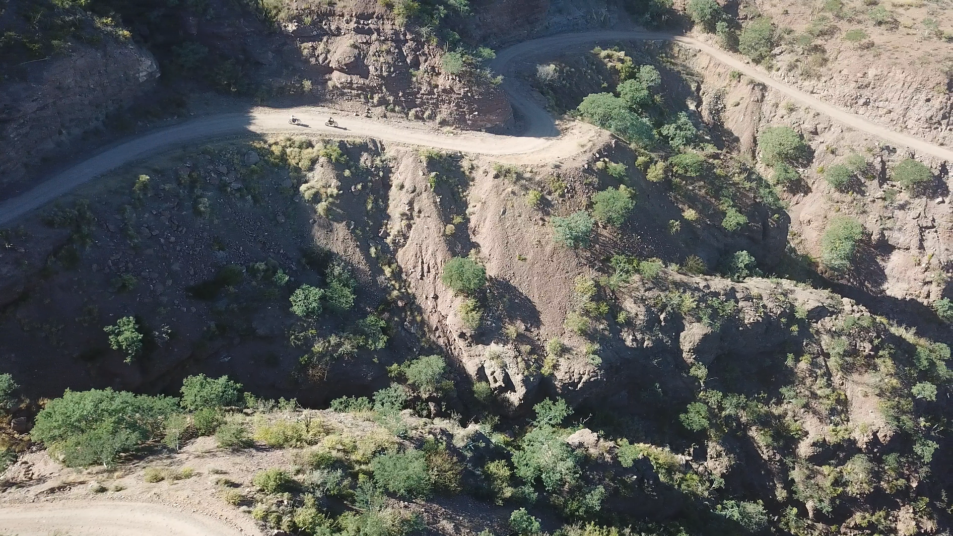
Perfect, that matches exactly what I have. I'm going go back and look at the wash again. It's only 2 miles until the turn up the mountain.
Pic I took riding down into AV two weeks ago.
[Edited on 12-4-2017 by JZ]
|
|
|
StuckSucks
Super Nomad
Posts: 2305
Registered: 10-17-2013
Member Is Offline
|
|
https://goo.gl/maps/s2iUrrx1gCz
|
|
|
JZ
Elite Nomad
Posts: 9226
Registered: 10-3-2003
Member Is Offline
|
|
Gonna be at that spot in 2 weeks and give it a go riding up the canyon.
[Edited on 12-4-2017 by JZ]
|
|
|
TMW
Select Nomad
Posts: 10659
Registered: 9-1-2003
Location: Bakersfield, CA
Member Is Offline
|
|
StuckSucks your readings are in degrees, minutes, seconds, is that what you normally use? Mine are in the standard GPS form of degrees and decimal
minutes, same spot.
|
|
|
JZ
Elite Nomad
Posts: 9226
Registered: 10-3-2003
Member Is Offline
|
|
| Quote: Originally posted by TMW | | StuckSucks your readings are in degrees, minutes, seconds, is that what you normally use? Mine are in the standard GPS form of degrees and decimal
minutes, same spot. |
I changed the option in GE to be degress and decimal mins, but it still stays at degrees, mins, secs. Need to figure out what is going on.
|
|
|
TMW
Select Nomad
Posts: 10659
Registered: 9-1-2003
Location: Bakersfield, CA
Member Is Offline
|
|
Did you remember to click OK after changing it?
|
|
|
JZ
Elite Nomad
Posts: 9226
Registered: 10-3-2003
Member Is Offline
|
|
I got it working. It was probably working last night, but I was drinking a couple beers and didn't realize it.
|
|
|
Tomas Tierra
Super Nomad
Posts: 1281
Registered: 3-23-2005
Location: oxnard, ca
Member Is Offline
Mood: Tengo Flojera
|
|
| Quote: Originally posted by JZ | | Quote: Originally posted by TMW | The turn off to the arroyo from the main road is at 25-30.94x111-05.09.
The road out of the wash and up the mountain is at
25-29.68x111-05.98. Once you start up the mountain the road is good to Constitucion. Great view at you go up the mtn. |
Perfect, that matches exactly what I have. I'm going go back and look at the wash again. It's only 2 miles until the turn up the mountain.
Pic I took riding down into AV two weeks ago.
[Edited on 12-4-2017 by JZ] |
That first part in the arroyo is by far the worst part of the whole thing.. Once you get on the up hill/switchbacks, it's not bad. I know they have
had a few decent rains since I went through in April, but it was just worked with at that point and in excellent condition.. Once you get up on top
it's kinda Ho hum.
Suerte!
Fwiw, I was n a mostly stock 05 tundra with a four wheel camper on the back..no prob.
TT
|
|
|
JZ
Elite Nomad
Posts: 9226
Registered: 10-3-2003
Member Is Offline
|
|
| Quote: Originally posted by Tomas Tierra |
That first part in the arroyo is by far the worst part of the whole thing.. Once you get on the up hill/switchbacks, it's not bad. I know they have
had a few decent rains since I went through in April, but it was just worked with at that point and in excellent condition.. Once you get up on top
it's kinda Ho hum.
Suerte!
Fwiw, I was n a mostly stock 05 tundra with a four wheel camper on the back..no prob.
TT |
Thx, thinking we are just gonna ride up it with the bikes and then come back down. Have a huge ride into San Evaristo 2 days later, so gonna save up
for that.
Will video the ride up.
|
|
|
Tomas Tierra
Super Nomad
Posts: 1281
Registered: 3-23-2005
Location: oxnard, ca
Member Is Offline
Mood: Tengo Flojera
|
|
| Quote: Originally posted by JZ | | Quote: Originally posted by Tomas Tierra |
That first part in the arroyo is by far the worst part of the whole thing.. Once you get on the up hill/switchbacks, it's not bad. I know they have
had a few decent rains since I went through in April, but it was just worked with at that point and in excellent condition.. Once you get up on top
it's kinda Ho hum.
Suerte!
Fwiw, I was n a mostly stock 05 tundra with a four wheel camper on the back..no prob.
TT |
Thx, thinking we are just gonna ride up it with the bikes and then come back down. Have a huge ride into San Evaristo 2 days later, so gonna save up
for that.
Will video the ride up.
|
There is some sort of structure/house right before you start up the grade.. We didn't see it until we were up quite a ways. May be worth a sniff..
It would be worth it to go to San Jose de la Noria and check it out. Couple nice ranchos and some water.. Turn around there and head back. You could
burn it pretty good on the bikes once you get on top..
Look forward to the video! I have some pretty good vid from April.. I put some up on TB, can't figure it out here..
TT
Have fun
|
|
|
JZ
Elite Nomad
Posts: 9226
Registered: 10-3-2003
Member Is Offline
|
|
So we rode up. Yeah, no truck is getting through there for a long while. Not far from the beginning of the climb up the canyon the road is washed
out with a rock slide.
Rocky for the next mile or two after that. One big patch, and then you hit a gate near the top. 500 feet past the gate is another slide. We stopped
there as that one looked like a mess.
From the turn off the main road just before Agua Verde until the top of the canyon we probably rode over 10K rocks. It was a rough 4-5 miles.
|
|
|
Desertbull
Senior Nomad
Posts: 558
Registered: 8-27-2003
Member Is Offline
|
|
We tried to go down in a capable truck last month ... no go big wash out into a canyon like you mentioned. Motos picked their way through...thanks for
the update sounds like its still the same, which is surprising because the local ranchers use that road a lot back and forth. Gracias.
| Quote: Originally posted by JZ | So we rode up. Yeah, no truck is getting through there for a long while. Not far from the beginning of the climb up the canyon the road is washed
out with a rock slide.
Rocky for the next mile or two after that. One big patch, and then you hit a gate near the top. 500 feet past the gate is another slide. We stopped
there as that one looked like a mess.
From the turn off the main road just before Agua Verde until the top of the canyon we probably rode over 10K rocks. It was a rough 4-5 miles.
|
DREAM IT! PLAN IT! LIVE IT!
|
|
|
TMW
Select Nomad
Posts: 10659
Registered: 9-1-2003
Location: Bakersfield, CA
Member Is Offline
|
|
That is a real bummer. That was such a neat drive. I hope they get it fixed soon.
|
|
|
Tomas Tierra
Super Nomad
Posts: 1281
Registered: 3-23-2005
Location: oxnard, ca
Member Is Offline
Mood: Tengo Flojera
|
|
| Quote: Originally posted by JZ | So we rode up. Yeah, no truck is getting through there for a long while. Not far from the beginning of the climb up the canyon the road is washed
out with a rock slide.
Rocky for the next mile or two after that. One big patch, and then you hit a gate near the top. 500 feet past the gate is another slide. We stopped
there as that one looked like a mess.
From the turn off the main road just before Agua Verde until the top of the canyon we probably rode over 10K rocks. It was a rough 4-5 miles.
|
Thanks for reporting back JZ.. Glad you guys made it safely. Beautiful up there, I feel fortunate to have been able to drive that last April. To bad
for the locals who use that road.. They had put a bunch of effort into fixing it nicely before we went.
TT
|
|
|
BigBearRider
Super Nomad
Posts: 1299
Registered: 4-30-2015
Location: Big Bear, Punta Chivato, and Cabo
Member Is Offline
Mood: 
|
|
I talked to someone who recently turned around on a moto as the road was too bad. I wish I could remember more. (The other week, I struggled to
remember where I had ceviche for lunch a few days prior. It came to me after a few days...)
|
|
|
StuckSucks
Super Nomad
Posts: 2305
Registered: 10-17-2013
Member Is Offline
|
|
| Quote: Originally posted by TMW | | StuckSucks your readings are in degrees, minutes, seconds, is that what you normally use? Mine are in the standard GPS form of degrees and decimal
minutes, same spot. |
I'm a little late to the party, but I deal with lat/lons for my job about 1000 times a day -- I work in digital degrees, eg: 25.494667, -111.099667
separated by a comma, sans degree symbol.
|
|
|
TMW
Select Nomad
Posts: 10659
Registered: 9-1-2003
Location: Bakersfield, CA
Member Is Offline
|
|
| Quote: Originally posted by Tomas Tierra |
There is some sort of structure/house right before you start up the grade.. We didn't see it until we were up quite a ways. May be worth a sniff..
It would be worth it to go to San Jose de la Noria and check it out. Couple nice ranchos and some water.. Turn around there and head back. You could
burn it pretty good on the bikes once you get on top..
Look forward to the video! I have some pretty good vid from April.. I put some up on TB, can't figure it out here..
TT
Have fun
|
It's a shed of sorts, abandoned or maybe a covered pen for animals. I stopped there the last time we went down the mtn.
|
|
|
Fernweh
Nomad
Posts: 444
Registered: 2-24-2011
Location: Centenario, BCS
Member Is Offline
|
|
So the back road into Agua Verde is still a mess, I take it.
No go for my 2x4 truck with bald tires?
Any recent update....por favor
|
|
|
| Pages:
1
2 |


