| Pages:
1
2
3
..
5 |
David K
Honored Nomad

Posts: 64480
Registered: 8-30-2002
Location: San Diego County
Member Is Offline
Mood: Have Baja Fever
|
|
Creating Custom Maps II: Baja California Sur
The other thread was getting a bit long and had a lot of help and experimentation as I tried to find a way to make maps for the road guide that could
be done on my computer and show just those places mentioned in the guide without too many extra distractions.
As I stated in the other thread, I found an online service for map making that provided the base (showing the coastline, mountains, and Highway 1)
without much else that was either wrong (the case with many online maps) or there was no way to easily add items to it.
These maps are to help one see where the locations are in relation to each other so the road guide will be clearer for the user to visualize where
they are.
I am sharing my work with my Nomad amigos for feedback, ideas of how or what could make them better, and on the chance, you guys may get some
entertainment or use from them. Only Highway 1 came with the base map, all other roads, all symbols, all names were added by me, using satellite
images for accurate placement. These maps are made for education and enjoyment.
After I touch up or change the Baja Norte maps posted in the other thread, I may repost them in a fresh thread for easier viewing.
Thank you!
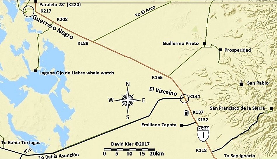
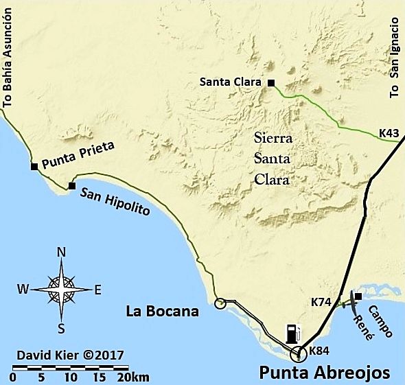
Today's work (so far): Vizcaíno Area...
|
|
|
4x4abc
Ultra Nomad
Posts: 4163
Registered: 4-24-2009
Location: La Paz, BCS
Member Is Offline
Mood: happy - always
|
|
in your previous map you showed Paraleo 28 at k 127 - now you show it at k 200.
Harald Pietschmann
|
|
|
4x4abc
Ultra Nomad
Posts: 4163
Registered: 4-24-2009
Location: La Paz, BCS
Member Is Offline
Mood: happy - always
|
|
as all signs along the highways in Baja show km 149 (for example) - why would you shorten it to k 149 and confuse people you intend to help
Harald Pietschmann
|
|
|
David K
Honored Nomad
Posts: 64480
Registered: 8-30-2002
Location: San Diego County
Member Is Offline
Mood: Have Baja Fever
|
|
Good eye Harald... except it is 220. It is BOTH 127 and 220!
Southbound in Baja Norte, it is Km. 127 and this map ends at that point:
Once you are on the south side of the Eagle (State Border), the kilometer markers change from southbound (getting bigger going south) to northbound
(getting smaller going south). It is Km. 220 and declines to Santa Rosalia (Km. 0).
|
|
|
David K
Honored Nomad
Posts: 64480
Registered: 8-30-2002
Location: San Diego County
Member Is Offline
Mood: Have Baja Fever
|
|
Quote: Originally posted by 4x4abc  | | as all signs along the highways in Baja show km 149 (for example) - why would you shorten it to k 149 and confuse people you intend to help
|
To keep the numbers as short as possible.
I really hope that a figure next to the highway saying K181 along with other suck K figures is clearly seen as being kilometer markers, as that is
what is in the guide text. Remember, these maps are supporting the guide (which does have it as Km. 181, by-the-way).
If I were making maps that have no guide text with them, I would include a legend to explain the abbreviations. N on the compass is North, but I hope
that doesn't need explaining. Until your comment, I would not dream that K with a number, along a Mexican highway, would need clarification.
If I make a general legend for the maps, I will show an example and say that K... is a kilometer marker.
Thank you, Harald! Happy New Year. I hope your leg is doing better!!
|
|
|
David K
Honored Nomad
Posts: 64480
Registered: 8-30-2002
Location: San Diego County
Member Is Offline
Mood: Have Baja Fever
|
|
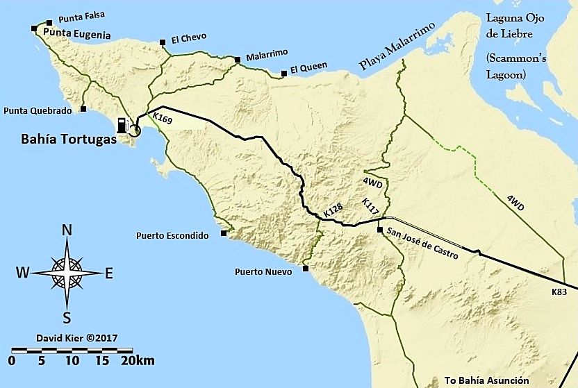
Bahía Tortugas Area
This morning's work (began last night)...
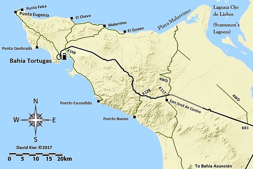
Edited with an addition, San José de Castro!
[Edited on 12-29-2017 by David K]
|
|
|
Special Ed
Newbie
Posts: 15
Registered: 9-20-2017
Member Is Offline
|
|
Love these maps, just moved to TJ and I can't wait to explore these areas for the first time this spring! Gracias David!
|
|
|
David K
Honored Nomad
Posts: 64480
Registered: 8-30-2002
Location: San Diego County
Member Is Offline
Mood: Have Baja Fever
|
|
| Quote: Originally posted by Special Ed | | Love these maps, just moved to TJ and I can't wait to explore these areas for the first time this spring! Gracias David! |
Welcome to Nomad and thank you for your reply!
Until the Baja Bound Road Guide is available, please see my 2017 Trip Reports (numbered 1-7) for many of the photos and road details... in the Nomad
Trip Reports Forum: http://forums.bajanomad.com/forumdisplay.php?fid=50
|
|
|
David K
Honored Nomad
Posts: 64480
Registered: 8-30-2002
Location: San Diego County
Member Is Offline
Mood: Have Baja Fever
|
|
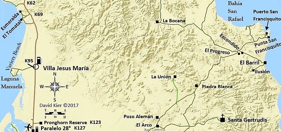
Next;
|
|
|
TMW
Select Nomad
Posts: 10659
Registered: 9-1-2003
Location: Bakersfield, CA
Member Is Offline
|
|
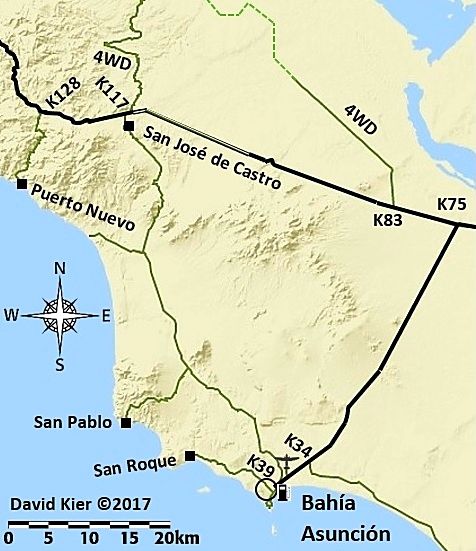
David why do you not show the pipeline road from K83 complete to the Malarrimo road?
|
|
|
David K
Honored Nomad
Posts: 64480
Registered: 8-30-2002
Location: San Diego County
Member Is Offline
Mood: Have Baja Fever
|
|
Next...
|
|
|
David K
Honored Nomad
Posts: 64480
Registered: 8-30-2002
Location: San Diego County
Member Is Offline
Mood: Have Baja Fever
|
|
I included it because it is mentioned in the guide as a possible alternate route to reach Malarrimo Beach. I did not drive it but I know some who
have, so I show it. However, the satellite image I am using to draw in the roads shows it vanishing under the sand dunes. If you or any Nomad have
driven it recently, I will be comfortable in connecting that gap... easy to do. I also could show it as a dashed line... maybe a good option?
Thank you... This is the input I appreciate!
DONE:
[Edited on 12-30-2017 by David K]
|
|
|
TMW
Select Nomad
Posts: 10659
Registered: 9-1-2003
Location: Bakersfield, CA
Member Is Offline
|
|
No I have not driven it, I had planned to on an upcoming trip. Dash lines sound like a good ideal.
|
|
|
David K
Honored Nomad
Posts: 64480
Registered: 8-30-2002
Location: San Diego County
Member Is Offline
Mood: Have Baja Fever
|
|
Final map for today!
Have a look, let me know what I could add (or take away).
Happy New Year!
Thanks to Mt.Goat666 noticing the error, the whale camp name has been edited to Pachico's.
[Edited on 12-30-2017 by David K]
|
|
|
David K
Honored Nomad
Posts: 64480
Registered: 8-30-2002
Location: San Diego County
Member Is Offline
Mood: Have Baja Fever
|
|
| Quote: Originally posted by TMW | | No I have not driven it, I had planned to on an upcoming trip. Dash lines sound like a good ideal. |
Harald sent me the track line of the road and I was able to then spot it on my satellite map making program... very faint, but it changed directions
as you see on the dashed line and that is why I lost it.
|
|
|
mtgoat666
Select Nomad
Posts: 17295
Registered: 9-16-2006
Location: San Diego
Member Is Offline
Mood: Hot n spicy
|
|
When did Pachico’s change their name to Pancho’s?
Woke!
“...ask not what your country can do for you – ask what you can do for your country.” “My fellow citizens of the world: ask not what America
will do for you, but what together we can do for the freedom of man.”
Prefered gender pronoun: the royal we
|
|
|
mtgoat666
Select Nomad
Posts: 17295
Registered: 9-16-2006
Location: San Diego
Member Is Offline
Mood: Hot n spicy
|
|
| Quote: Originally posted by David K | | I wrote down the name off the sign. All the campos were closed for summer when I was there. I chatted with a caretaker at Kuyima.
|
You better go back and read the signs again 
Woke!
“...ask not what your country can do for you – ask what you can do for your country.” “My fellow citizens of the world: ask not what America
will do for you, but what together we can do for the freedom of man.”
Prefered gender pronoun: the royal we
|
|
|
mtgoat666
Select Nomad
Posts: 17295
Registered: 9-16-2006
Location: San Diego
Member Is Offline
Mood: Hot n spicy
|
|
| Quote: Originally posted by David K | This is why I am running these maps here, so any mistakes can be found. I did post the name Pancho's in my trip report last August with no corrections
mentioned.
In any case, thank you goat! |
I did not know you were seeking review of maps, until now,...
Suggest you avoid asking gringos for reviews. You will get more useful reviews if you send maps to locals for review.
Btw, on subject map, you don’t show the inland road that runs over and east of cuarenta Mesa. But, like I said, send map to a local for a more
informative review, they know way more than us tourists....
Woke!
“...ask not what your country can do for you – ask what you can do for your country.” “My fellow citizens of the world: ask not what America
will do for you, but what together we can do for the freedom of man.”
Prefered gender pronoun: the royal we
|
|
|
David K
Honored Nomad
Posts: 64480
Registered: 8-30-2002
Location: San Diego County
Member Is Offline
Mood: Have Baja Fever
|
|
The Cuarenta road is there but the map ends just south of the split between that road and the Salina road.
From the very start, I made it clear I appreciated feedback to help make the maps better. I made the roadguide so I am making the maps to show the
roads I traveled and others I noted or mentioned in the guide text.
As for 'locals' contributing, they have when I ask them questions about their facility. As the map and guide are for visitors who read English and
have vehicles that register miles, I don't know how much more they can provide? Being that I began traveling in Baja since 1965 and driving myself
there since 1974, I think I am qualified to write about driving in Baja and seeing the interesting sites most locals have never been to. I lived in
California for 60 years but am not qualified to write about it simply because I am a "local". On the other hand, I have traveled and researched Baja
California extensively as it is the place that I have the greatest passion for.
|
|
|
MulegeAL
Nomad
Posts: 298
Registered: 8-25-2009
Location: PDX/Mulege
Member Is Offline
|
|
DK,
Does your road guide have info on road conditions such as high clearance, sand, etc? I have traveled most of your "little green lines" (as it is my
passion as well) and know maps are just a place to start with being prepared.
My concern is that these maps will wind up as screen dump printouts in rental cars, and maps can't show all the data for a green line adventure.
Maybe more dashed green lines would help where there are rough steep passes or lots of washouts like on the middle "road" east of the El Datil Salina
road. Bailout info is hard-won, not sure how to show that, maybe in your guide. The green lines in my locale have taken another beating from storms
and have even more rocks and ruts than last season.
I still see travelers in the interior with nothing more than AAA map and they were having a good time/came out alive.
Last month I ran copy of the Almanac for two bicycle riders who had no idea of the topography ahead, only a waypoint list and something on a solar
powered GPS. They were asking me if they could find water to filter in the Comondus routes.
Nice maps, keep them coming, thanks!
|
|
|
| Pages:
1
2
3
..
5 |


