| Pages:
1
2
3
4
5 |
Udo
Elite Nomad

Posts: 6321
Registered: 4-26-2008
Location: Black Hills, SD/Ensenada/San Felipe
Member Is Offline
Mood: TEQUILA!
|
|
Happiest of New Year's David!
I wanted to thank you for the designation of 4WD on your custom maps. It really helps in determining future adventure in the off-road challenges of
Baja.
Udo
Youth is wasted on the young!
|
|
|
David K
Honored Nomad
Posts: 64479
Registered: 8-30-2002
Location: San Diego County
Member Is Online
Mood: Have Baja Fever
|
|
Happy New Year to you too!
While I would probably recommend everyone have a 4WD vehicle who leaves the pavement in Baja, the reality that in dry weather one rarely NEEDS 4WD to
travel most dirt roads.
I will put 4WD next to roads that had places where 4WD made the drive either possible or a whole lot safer. In some cases the extra ground clearance
of a 4WD is needed because of rocks or ruts, but not the traction.
Obviously, a bulldozer or grader can make a bad 4WD road passable in 2WD or a flash flood can make a good graded road need 4WD. So, these are
suggestions or recommendations. Driving skill has a whole lot to do with needing 4WD or ground clearance.
I am sure glad to hear from Nomads as I can taylor these maps based on your comments.
I bet I will eventually add mileages to them. Not necessarily for the guidebook but for posts on Nomad.
|
|
|
4x4abc
Ultra Nomad
Posts: 4163
Registered: 4-24-2009
Location: La Paz, BCS
Member Is Online
Mood: happy - always
|
|
what is K37 for?
Harald Pietschmann
|
|
|
mtgoat666
Select Nomad
Posts: 17295
Registered: 9-16-2006
Location: San Diego
Member Is Offline
Mood: Hot n spicy
|
|
Quote: Originally posted by David K  | Happy New Year to you too!
While I would probably recommend everyone have a 4WD vehicle who leaves the pavement in Baja, the reality that in dry weather one rarely NEEDS 4WD to
travel most dirt roads.
I will put 4WD next to roads that had places where 4WD made the drive either possible or a whole lot safer. In some cases the extra ground clearance
of a 4WD is needed because of rocks or ruts, but not the traction.
Obviously, a bulldozer or grader can make a bad 4WD road passable in 2WD or a flash flood can make a good graded road need 4WD. So, these are
suggestions or recommendations. Driving skill has a whole lot to do with needing 4WD or ground clearance.
I am sure glad to hear from Nomads as I can taylor these maps based on your comments.
I bet I will eventually add mileages to them. Not necessarily for the guidebook but for posts on Nomad.
|
Dk,
The most common way to draw maps is to use different line types for road type.
For conventional line types, see forest service maps.
You may be better off with 3 line types: paved, unpaved/maintained, unpaved/not maintained.
Woke!
“...ask not what your country can do for you – ask what you can do for your country.” “My fellow citizens of the world: ask not what America
will do for you, but what together we can do for the freedom of man.”
Prefered gender pronoun: the royal we
|
|
|
David K
Honored Nomad
Posts: 64479
Registered: 8-30-2002
Location: San Diego County
Member Is Online
Mood: Have Baja Fever
|
|
It is where the highway crosses Arroyo La Purísima... that is in the road log and showing it on the map helps see the direction the kilometer markers
are running on that road, if just glancing at the map.
Again, the maps are connected to the road logs in the guide... so I know they may not be totally clear when looked at without the guide text. I am
only putting the actual kilometer points on the map, so you will see that marker when you pass that point. Many of the points in the road log are
between kilometer markers. If I have a marker for that point on the map, it will be a whole number and put just above or below the map point.
-----------------------------------------------------------------------------------------------------------
Mtgoat666:
Yes, I would love to show three or more road types. I did try to do that on my earlier ones and if the road is being paved, I show it as two parallel
lines (see the road to La Bocana from Abreojos, for example).
However, the choices I have do make that VERY difficult to do. One problem is the Arc base map only has the one single line for me to trace over
satellite images of roads I want to show. Only Hwy. 1 is on the base map. All other paved or dirt roads, I need to trace over then I switch the base
map from satellite to the one you see above that shows the mountains, etc.
When I paste the base map over to Word to add everything else, I need to redraw over the paved roads (other than Hwy. 1) and adjust the color and
width. If I want parallel lines for dirt roads or dashed lines for poor roads, then the trace line drawn on Arc is also there and a real mess to try
and draw over or erase with a color the same as the map surface. To not draw in the roads on the base map would mean roads I add over on Word may not
be exactly placed right and I would have to switch back and forth between windows to try and draw in the road where it is. I did that on the road to
Mission Santa María, and that was no fun to do!
Ideally: solid thick black lines for paved roads, parallel thin lines for dirt roads, cross lines inside the parallel lines for graded roads, dashed
parallel lines for poor roads.
Until I learn how to do that, the guide will describe the roads... beyond where I put 4WD on the map in a few places.
Thank you for the observations.
[Edited on 1-1-2018 by David K]
|
|
|
David K
Honored Nomad
Posts: 64479
Registered: 8-30-2002
Location: San Diego County
Member Is Online
Mood: Have Baja Fever
|
|
Today's Work
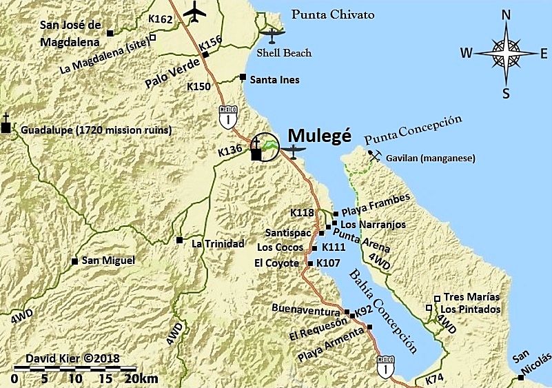
After I made this, I noticed I forgot to include a gas pump icon by Mulegé. If you guys see anything else that needs addressing, I won't do the
add-on until later... Thank you!
|
|
|
David K
Honored Nomad
Posts: 64479
Registered: 8-30-2002
Location: San Diego County
Member Is Online
Mood: Have Baja Fever
|
|
Here's a revised map I had made early on, of the roads to the missions and beyond from Cd. Constitución to San Evaristo...
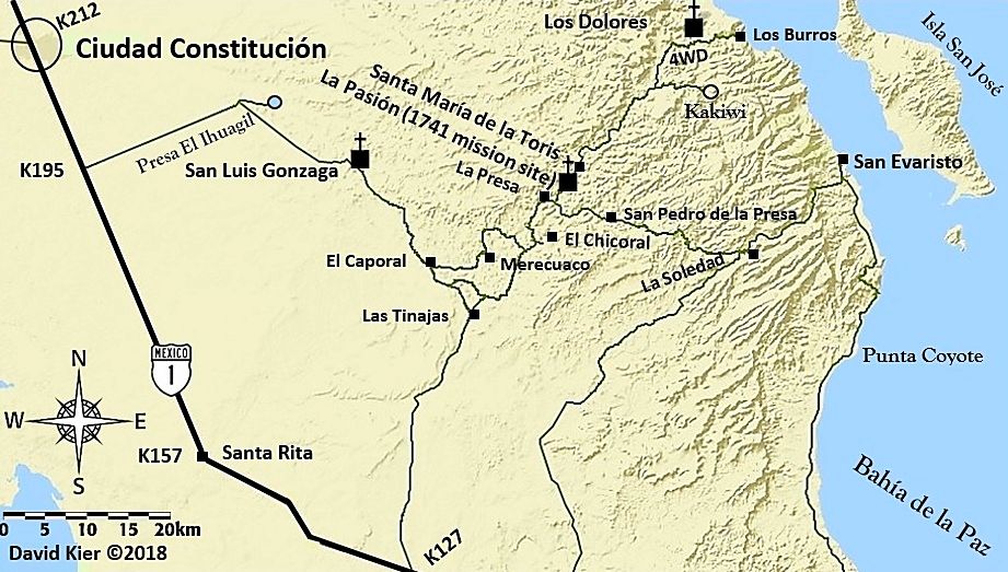
I decided to thicken up Highway 1 and make it black to stand out from the base version.
|
|
|
MulegeAL
Nomad
Posts: 298
Registered: 8-25-2009
Location: PDX/Mulege
Member Is Offline
|
|
| Quote: Originally posted by David K |
After I made this, I noticed I forgot to include a gas pump icon by Mulegé. If you guys see anything else that needs addressing, I won't do the
add-on until later... Thank you! |
DK,
Happy New Map!
The green line going south (towards Paso Hondo) where you show the 4WD symbol: that section is impassible, not even "dotted green line". The
destroyed section starts at the bottom of the Chuparossa canyon on the north side of the pass and continues up almost to the pass.
I went up there, walked up a half mile beyond where I could barely climb with my good bike. The local rancho guys park at the corral at the bottom
and ride in with mules, walking them through the worst sections. Had tailgate Nescafé with them and discussed the area.
The next pass to the south is also impassible, the one just north of rancho Guajademi. I haven't seen that myself for 3 seasons, but I have no reason
to doubt the advice of local rancho guys.
Suggest milage be suffixed as "MM" >> Mexico Miles! They are way longer than USA miles!
|
|
|
David K
Honored Nomad
Posts: 64479
Registered: 8-30-2002
Location: San Diego County
Member Is Online
Mood: Have Baja Fever
|
|
Good morning Al,
Thanks for that. I thought Kurt G drove his Explorer over it not too long ago?
EDIT: His trip was in 2012. The rains of 2014 and after sure did a number on the roads, such as the one from San Jose de Magdalena up to Mission
Guadalupe.
So, the road south of La Trinidad where it climbs the mountain is gone and not likely to be fixed anytime soon, eh?
Kurt's Trip on that road (I added some extra spacing):
Trip Report/road log San Isidro-Mulege Mountain Route 3/22/2012
For reference our vehicle is a 2000 Explorer stock Bauer Ed. with 255/70/16 Michelin street tires run at about 22#.
The report is a mileage log and includes GPS data and elevation for key points. The log is as accurate as Garmin and Ford's odometer could provide.
Mile Zero is starting North from San Isidro at 26.12.866x112.01.577.
Excellent road to Purisima Vieja at mile 12.3 then to Paso Hondo at mile 15.4. Both are oasis villages with some great scenery.
Mile 17.8-Springs and ponds on left.
Mile 18.3-Small village.
Mile 21.2-water crossing/palms and on to Buenos Aires at mile 25.9.
Mile 29.1-Agua Grande
Mile 32.2. 26.32.962x112.06.834. Elev.2100. Sign: El Llano straight, Guajadami to the right. Go straight.
From here the road is steep and rocky with a lot of erosion. Low range used to the top of high plateau at Mile 36.7. Elev. 3350 at
26.35.899x112.07.222.
Mile 37. Incredible views of deep gorge on right. Continue to climb to:
Mile 39.1. 26.37.146x112.06.743. Elev. 3765. High point overlooking the broad expanse of El Llano below. This is where the road ended when I attempted
this route some 15 years ago. The descending cuesta was the most difficult of the entire trip. Steep, sometimes narrow and off camber and rough eroded
rock with lots of loose stuff. This is an area to use extreme caution. We crept down in low range, 1st gear to arrive in the flats of El Llano at:
Mile 40.6. 26.37.786x112.07.153. Elev. 2616. At this point we met a rancher with a Ford F350 4wd and a cattle rack who had 3-4 cattle loaded. We told
him we were going to Mulege and he said he was as well. That gave us a better feeling about actually completing the trip since I didn't feel we could
climb back up that previous cuesta or at least really didn't want to attempt it. He confirmed that that plateau is El Llano. As we started up the next
grade we saw him starting behind us. A rough ride for those cows! The road continues up and down a bit before a gate at the top of the final cuesta
at:
Mile 43.1. 26.39.029x112.08.07. Elev. 3429. Now down the cuesta, steep and rough but not nearly as bad as the earlier one. There has been traffic up
and down this area since we were on it and turned back a few months ago. I think we could now go up this one ok.
Mile 46.2. 26.40.320x112.07.130. elev. 1346. This position is right by the ranch at the bottom of the cuesta. Rancho El Llanito, I believe. It is
relatively new. This is the important coordinate for anyone doing this trip north to south since it is not shown on the maps and in my experience the
Baja Atlas and other maps are only an approximation of the roads in this area. From this point you are on the road that goes straight to Mulege.
There are occasional roads that come in from both side notably at Mile 50.8 which has a sign pointing to Rcho El Llanito. I believe the other fork
here leads to the area of El Potrero and El Batiqui and the appropriately named Pia de la Cuesta Guajadami. I have motorcycled in that area but not
since the hurricanes changed some of the roads a few years ago. Note that I have not called this the Guajadami Road since it splits off from the old
mission route and is generally to the west of it. Continue straight into Mulege arriving at Hwy 1 (icehouse road junction) at MILE 67.3. This trip
took about 6 hours so an average speed of about 10 mph. Thanks to Mulegena for the trip report on Baja Nomads that inspired us to do this trip. The
scenery was wonderful although I would still rank the San Juan de la Pila road as the slightly more spectacular but I am really splitting hairs on
that call. Do them both and tell me what you think!
Kurt and Kathy, March 22, 2012
I blotted out the road up the mountain and beyond...
[Edited on 1-2-2018 by David K]
|
|
|
MulegeAL
Nomad
Posts: 298
Registered: 8-25-2009
Location: PDX/Mulege
Member Is Offline
|
|
DK,
Thanks for posting up that old report, brings back memories (good and bad!)
2012 is before Hurc Paul did that road in for good. I did it with my neighbor about that time, last time I have done the whole route, S to N.
There used to be a Ford pickup in the valley there, and that screws with my head. I think it was left there, or there is another way in and out that
I do not know of.
It's so near, yet so far, hence my interest in getting back in there before (or when) I die! And there are other interesting places there that are
worth a day hike with a machete to access.
I am thinking access may be possible from the south, but it will be a project to get in there and north past rancho Guajadami.
|
|
|
David K
Honored Nomad
Posts: 64479
Registered: 8-30-2002
Location: San Diego County
Member Is Online
Mood: Have Baja Fever
|
|
Did my edit of the map meet with your approval to show the road not going through? I very much appreciate the feedback. I have made 3 base maps to
cover La Paz to Cabo, so I will soon have those ready. Not sure if I need more of Baja Sur illustrated in maps, but they would be San Ignacio to near
Punta Chivato, Loreto to Cd. Constitucion, Mag Bay. Stay tuned!
|
|
|
KurtG
Super Nomad
Posts: 1201
Registered: 1-27-2004
Location: California Central Coast
Member Is Offline
Mood: Press On Regardless!!
|
|
David,
Fun to see that trip report from almost 6 years ago. It is spectacular country back there and I am glad we were able to take advantage of the short
time that the road was doable, at least for our rig. There were a couple of times that I had doubts about being on that route by ourselves but it
worked out. That old Explorer is still going strong at over 300k miles and will be back in Baja Sur in a couple of months.
Kurt
edit: David, I have good pics of that trip. If you would like to see/use them I can put them on disc or a thumb drive and send them to you.
[Edited on 1-3-2018 by KurtG]
|
|
|
MulegeAL
Nomad
Posts: 298
Registered: 8-25-2009
Location: PDX/Mulege
Member Is Offline
|
|
DK,
Your edit looks good to me! The sign/junction mentioned in Kurt's report at mile 32.2 is likely as far as one can get these days, and a fair ending
for your map. Maybe a bit farther, or off to the east to the rancho Guajademi. That may be more detail than you want to show.
Too bad, as the canyon view he mentions farther up at m37 is spectacular.
I went back into my files. Last time I was at that junction was Feb 15, 2014, and we went all the way through back to Mulege. The grades at the
passes were very difficult and eroded. We had serious brake problems on my pal's buggy going down. That was over a year after hurricane Paul. So it
was the next hurricane that took out the passes.
Hope to get back in there this year and "find the end of the road."
|
|
|
David K
Honored Nomad
Posts: 64479
Registered: 8-30-2002
Location: San Diego County
Member Is Online
Mood: Have Baja Fever
|
|
Great to hear, Al...
Hi Kurt, thanks for your popping in!
If the road is not passable it may be a cruel tease to show the photos? LOL
I have maps to work on for the Baja Bound Road Guide... so that will keep me occupied for a bit... just taking a break!
|
|
|
4x4abc
Ultra Nomad
Posts: 4163
Registered: 4-24-2009
Location: La Paz, BCS
Member Is Online
Mood: happy - always
|
|
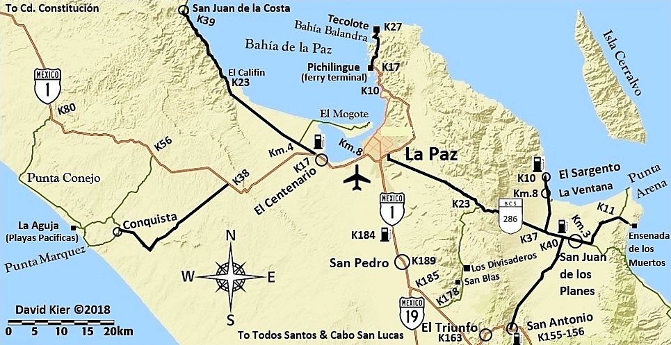
El Califia = Califin
Los Divasaderos = Los Divisaderos
Ensenada de los Muertos = Ensenada de los Sueños
El Magote = El Mogote
Harald Pietschmann
|
|
|
David K
Honored Nomad
Posts: 64479
Registered: 8-30-2002
Location: San Diego County
Member Is Online
Mood: Have Baja Fever
|
|
Great Harald... thank you!
I got an email from Rob with many of those comments. Mogote spelling was indeed my error! I used my ears and not my eyes!
As for Divisaderos, that is the historic (1962) and current (2009) Almanac and last (2010) AAA spelling. So, a typo I will fix!
Califin, got it! That is what my notes say, too.
Los Sueños is a marketing name. Los Muertos is the historic name and I am the history nut... There was nothing much of interest at the Los Sueños
site... all the action was at the boat landing, restaurant, and the old ore loading dock of Ensenada de los Muertos.
Thank you!!
[Edited on 1-4-2018 by David K]
|
|
|
4x4abc
Ultra Nomad
Posts: 4163
Registered: 4-24-2009
Location: La Paz, BCS
Member Is Online
Mood: happy - always
|
|
what is the base software you use for your maps (the landscape background)?
Harald Pietschmann
|
|
|
David K
Honored Nomad
Posts: 64479
Registered: 8-30-2002
Location: San Diego County
Member Is Online
Mood: Have Baja Fever
|
|
La Paz Area with edits, thanks to rob and 4x4abc
|
|
|
David K
Honored Nomad
Posts: 64479
Registered: 8-30-2002
Location: San Diego County
Member Is Online
Mood: Have Baja Fever
|
|
Earlier (in the How to make maps 101 thread) I showed all the steps and even named the mapping website I get the base (terrain) map from.
Here again, are the steps I have been doing... takes me about a day per map, depends on the amount of detail...
Step 1 is to pick a region of Baja. So far, I have done two scales as you can see from the scale bars on the maps. One is 6 km. bar and allows better
detail if many roads or points are in the area of interest. The other is 10 km. and can cover from Pacific to Cortez or larger areas of Baja. This is
the scale I am doing more at.
The next map I will make will be from the bottom of my previous one, approx. Punta Rosarito on the Pacific and Pancho's San Rafael, on the gulf south
to the state border.
Here is the base map at 10 km. scale and basically it gives you the coastline, mountains, and Highway 1, almost nothing else. Maps are all oriented
with north at the top, but I add a compass rose because I think it is cool to have one on a map.
This is my base map, without enhancement, everything else you will see I add to it. I cropped the bottom of it at the state border and I removed a
small toolbar for changing the size of the map by coloring over it, if you have good color vision, you may see the slightly different shade of blue in
the upper left corner:
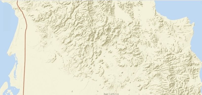
So, besides topography and the ocean/gulf only Highway 1 is shown and the state name along the border.
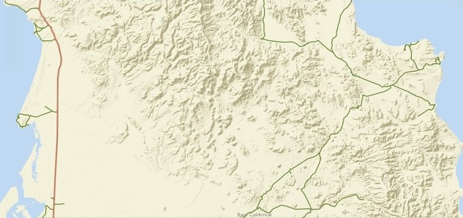
STEP 2
Add in the roads I want to show. These are roads I traveled this year that are being included in the Guide (exception is the Valle La Bocana road).
Other than Highway 1, all the roads are hand drawn in traced from the satellite image. The base map can be switched from the Road map to Satellite
image, then a pencil or line tool allows one to draw in the roads desired.
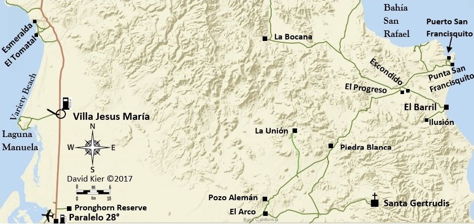
Next step (after a break, as I am exhausted and hungry) will be to add in icons for highway signs, gas pumps, airports, missions, the compass and
scale bar. I also then add in the place names and small black squares or circles for places on the map.
STEP 3: Add most of the rest! Names, Symbols, Icons, I even added a road I forget to earlier (to La Unión). I think I just need to add Km. markers
along Hwy. 1 and then enhance the image...
STEP 4: Add in the kilometer markers at the desired locations. Again, these additions are all done in Word. The text is added in using the Text Box:
Draw Text Box choice. The font size is adjusted if needed and generally, I make the font bold to be easier to read. For terrain/ocean names I use a
different font. The whole idea is to customize to fit the map.
Besides adding the km. marker points, I also noticed I needed to add a road out to the old Laguna Guerrero Negro salt dock.
Finally, I enhance the map colors in my Photobucket hosting Photo Editing feature.
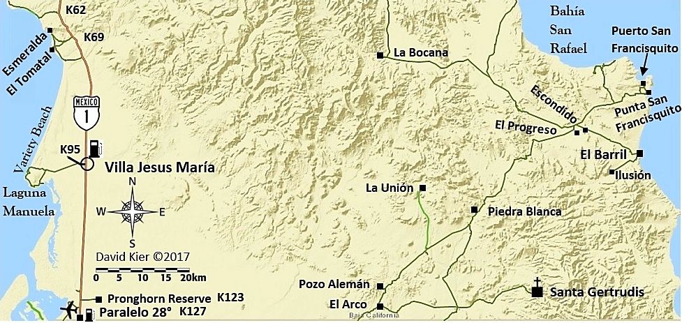
I can always go back to the map, saved in Word, and add more.
The steps from Word to Nomad are numerous and perhaps there is a better way. This just how I figured out how, so if you want to do the same, maybe it
will help?
A) Get Base Map. I used ArcGIS and chose the base map "Streets" but flipped back to "Imagery" (satellite view) and edited with "Map Notes" to draw in
roads. Once done, I use Print Screen (on the keyboard) and then Paint, Paste, Save... convert PNG to JPEG, Save. Then go to Documents, Pictures, Edit,
Crop, Close File.
B) Open up Word and pick a blank sheet and the Insert, Picture (pick the maps I just saved in Pictures), and begin to add in icons, roads, text all
using Insert (Pictures, Shapes, Text Box).
C) When done, click on the map, click Format, click Corrections and fine tune the map image, if needed. Have the map (on Word) as large as the window
will allow without cutting the map off and then perform the Print/Paste operation again (Paint, Paste, Save... convert PNG to JPEG, Save. Then go to
Documents, Pictures, Edit, Crop, Close File).
Anyway, that is my method (for now) and if you want to try and make maps to show, I hope this tutorial will be of assistance. Feel free to email or
u2u me any questions.
[Edited on 1-5-2018 by David K]
|
|
|
advrider
Super Nomad
Posts: 1847
Registered: 10-2-2015
Member Is Offline
|
|
Love these maps, I like them with the mileage like you did on the first one. What about just making the numbers smaller? Could these maps and the KM
page that you made be pinned at the top of one of the pages to make it easier to find at a later date?
|
|
|
| Pages:
1
2
3
4
5 |
|


