| Pages:
1
2
3
4
5 |
David K
Honored Nomad

Posts: 64479
Registered: 8-30-2002
Location: San Diego County
Member Is Offline
Mood: Have Baja Fever
|
|
Thanks advrider!
When the maps are done, refined, and you guys find all my silly errors, I will do a new post with them all... or, you can get the Baja Bound Book when
it's (if it's) published.
|
|
|
David K
Honored Nomad
Posts: 64479
Registered: 8-30-2002
Location: San Diego County
Member Is Offline
Mood: Have Baja Fever
|
|
OK, well... having refined my work using these 'caveman methods' on the computer (yes, I have heard Photoshop is a whole lot easier, etc.)... Here is
my new version of the Gonzaga Bay area map. Which was one of my first areas to do over a month ago... Please, your reviews:
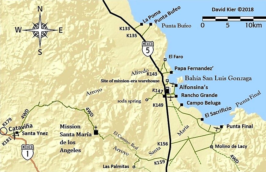
Remember, what is on the map is limited by what is mentioned in the roadguide. Mileages along the dirt roads are in the roadguide so as to not clutter
up the map too much. The maps are to complement the roadguide so the reader can "see" where places in the guide text are, in relation to other places.
I hope to have newer samples of the roadguide for you to see soon, following all the editing since the previous version I have shared here.
|
|
|
David K
Honored Nomad
Posts: 64479
Registered: 8-30-2002
Location: San Diego County
Member Is Offline
Mood: Have Baja Fever
|
|
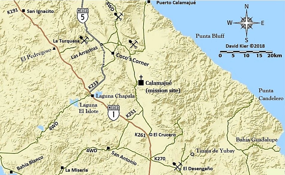
Here's another remake of an earlier map... that goes just south of the above map of Gonzaga Bay... including the new Highway 5 route:
|
|
|
David K
Honored Nomad
Posts: 64479
Registered: 8-30-2002
Location: San Diego County
Member Is Offline
Mood: Have Baja Fever
|
|
Once I finish the maps down the peninsula I want to have for the guide, I think I will do another set of them for Baja Nomads and other amigos with
mileages on selected dirt roads... as I know how all of us Baja map nerds enjoy the Auto Club (and some roads in the Almanac) maps that have the
mileages included.
I have two more maps to make to cover La Paz to Cabo and I may make ones to include San Ignacio to Santa Rosalía and the San Quintín area, both
places are not covered by the ones I have made so far.
Viva Baja everyone!
|
|
|
David K
Honored Nomad
Posts: 64479
Registered: 8-30-2002
Location: San Diego County
Member Is Offline
Mood: Have Baja Fever
|
|
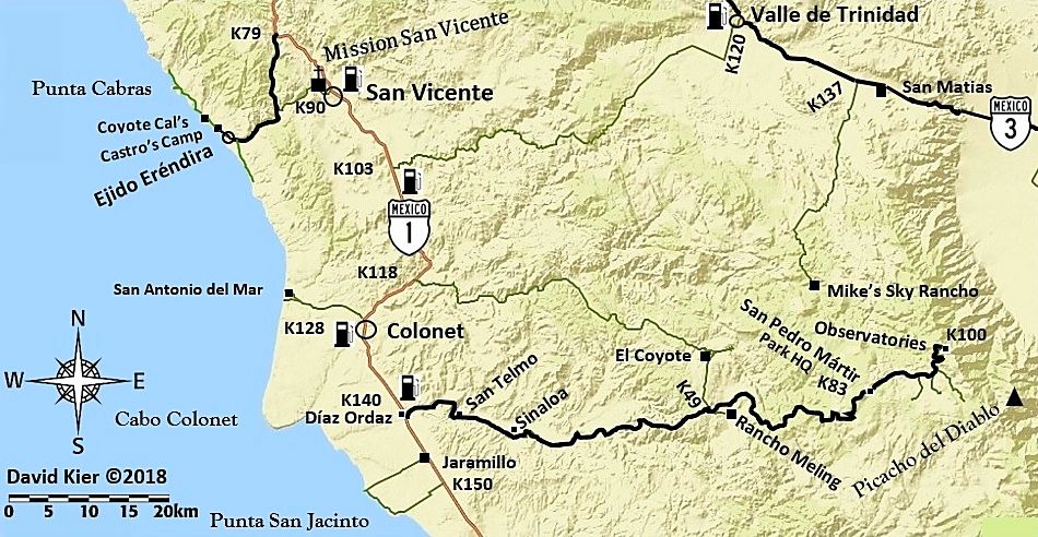
Ok, I have gone over all the previous maps I have made, done touch-ups and additions... here is the San Pedro Mártir area one with the upgrades...
Now, I will get back and do the last two going to Cabo. I just had to upgrade all the ones I made already before continuing.
|
|
|
David K
Honored Nomad
Posts: 64479
Registered: 8-30-2002
Location: San Diego County
Member Is Offline
Mood: Have Baja Fever
|
|
Okay, back to Baja Sur!
The next area, south of La Paz that show roads I was on last August or have mentioned in my roadguide... Feedback is welcome! Did I make any typos or
brain farts with names? Thank you!
One more to go for the peninsula and then maybe a couple more fill in maps, if I think they are needed.
When you see the guide, it works well without maps. However, I love maps and a Baja book should always have maps, IMO! They help you to see where you
are in proximity to other places.
|
|
|
MulegeAL
Nomad
Posts: 298
Registered: 8-25-2009
Location: PDX/Mulege
Member Is Offline
|
|
DK,
Nice maps, thanks. Can't come to publication soon enough.
Last evening I was commenting on GPS tracks some visiting riders had on smartphones. The data and tracks they were using around here show 4 rideable
through-routes out of the western valley, when in reality there is only one now, due to hurricane damage.
They had been balked by the impassible road damage south of San Jose de Magdelena towards the Guadelupe mission and had to backtrack out, so they were
ready to listen to local advice.
There is something about a displayed GPS track that travelers want to believe is real, maybe because they are so convenient to use when they are
right.
|
|
|
David K
Honored Nomad
Posts: 64479
Registered: 8-30-2002
Location: San Diego County
Member Is Offline
Mood: Have Baja Fever
|
|
Yes Al, gps tracks, maps, and guidebooks are only really accurate the day they are made and natural or human activity can quickly change everything!
|
|
|
StuckSucks
Super Nomad
Posts: 2306
Registered: 10-17-2013
Member Is Offline
|
|
Quote: Originally posted by MulegeAL  | | They had been balked by the impassible road damage south of San Jose de Magdelena towards the Guadelupe mission and had to backtrack out, so they were
ready to listen to local advice. |
Isn't this where either Darwin or Common Sense wins? The GPS is a magical tool, but you also have to balance that data with your street smarts.
|
|
|
advrider
Super Nomad
Posts: 1847
Registered: 10-2-2015
Member Is Offline
|
|
I'm guessing the missing section of the 4WD road going East past Mission Santa Maria turning to the El Camino Real and then coming out near KM159 is
where the Bill Nichole's trail ran/runs? Has anyone been able to ride it in recent years? I read an old report on here of someone running it years
back but wondered if it still existed? Maps are looking good!
|
|
|
advrider
Super Nomad
Posts: 1847
Registered: 10-2-2015
Member Is Offline
|
|
I agree with GPS tracks as a guide, not as the holly grail! If the tracks turn from two track to a goat trail and then down a raging river bed,
chances are something has changed! I use them a lot, but if I haven't ridding a track I always keep my eyes and options open. There are some good
stories of people driving into lakes and rivers following tracks!
|
|
|
PaulW
Ultra Nomad
Posts: 3005
Registered: 5-21-2013
Member Is Offline
|
|
How about the 18 wheeler - big tractor and a 53' trailer - tried to go over Engineer Pass in Colorado. He got hung up on the first turn and it took a
week to get him back to Silverton. He said his GPS told him it was a good road.
|
|
|
David K
Honored Nomad
Posts: 64479
Registered: 8-30-2002
Location: San Diego County
Member Is Offline
Mood: Have Baja Fever
|
|
| Quote: Originally posted by advrider | | I'm guessing the missing section of the 4WD road going East past Mission Santa Maria turning to the El Camino Real and then coming out near KM159 is
where the Bill Nichole's trail ran/runs? Has anyone been able to ride it in recent years? I read an old report on here of someone running it years
back but wondered if it still existed? Maps are looking good! |
The El Camino Real from just east of Mission Santa María to the desert near Gonzaga Bay is only for hikers or very good mules! It was too dangerous
for Graham's mule back in 1997, however. It is not a Bill Nichols Trail m/c trail.
One motorcyclist has proven to me to have made it (long ago) from Gonzaga to the mission and back on ECR, and that was Kevin Ward (Dust to Glory
producer, Baja racer). I think it is also 'normal' to say Malcolm Smith has also done it.
You can expect to dump your ride and have a burnt clutch if you try... great harm may come as you are next to the steep canyon side for many parts of
the trail!
|
|
|
David K
Honored Nomad
Posts: 64479
Registered: 8-30-2002
Location: San Diego County
Member Is Offline
Mood: Have Baja Fever
|
|
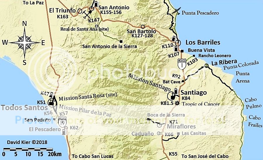
Los Cabos Map!
Have a look amigos... let me know if what I have included seem correct.
The whole San Lucas-San José corridor is a big zoo/ city. I did show three places you can access the beach.. the rest is hotels, condos, and you are
lucky if you can see the water from the highway now!
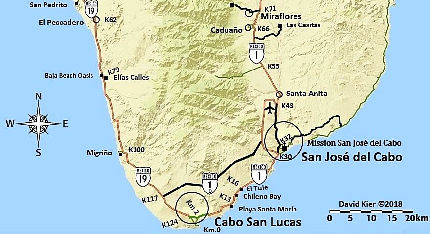
Yes, that is the Naranjos Road at K55 and I am not showing it crossing the mountains because it has been plagued by constant rain damage and I think
it is just wiser to not make it look like any kind of shortcut.
Here is what I have in my road log:
Km. 54.5 The Los Naranjos Road. A sometimes-challenging route over the top of the mountains to the Pacific side, it is frequently
damaged by summer storms.
[Edited on 1-9-2018 by David K]
|
|
|
4x4abc
Ultra Nomad
Posts: 4163
Registered: 4-24-2009
Location: La Paz, BCS
Member Is Offline
Mood: happy - always
|
|
I have hiked the missionary trail to Santa Maria many times. I have seen MC tracks on it on occasion. Did not think it was too difficult for MCs. I
have a strong suspicion that Arturo Gross worked this trail. No other part of the camino real north or south is in as good shape as this one.
Harald Pietschmann
|
|
|
David K
Honored Nomad
Posts: 64479
Registered: 8-30-2002
Location: San Diego County
Member Is Offline
Mood: Have Baja Fever
|
|
| Quote: Originally posted by 4x4abc | | I have hiked the missionary trail to Santa Maria many times. I have seen MC tracks on it on occasion. Did not think it was too difficult for MCs. I
have a strong suspicion that Arturo Gross worked this trail. No other part of the camino real north or south is in as good shape as this one.
|
Arturo Grosso and Dick Daggett are both responsible for many mine supply roads between Gonzaga and Chapala/ Calamajué. Their trails were more of
wagon roads, however.
I am not sure if the goat trail size ECR being discussed here along the cliffside is anything more than the mission trail built sometime after the
Franciscans arrived. Serra used the Jesuit (Indian) trail, in the canyon, and that climbed out on what we have been calling the Indian Trail (goes up
from the canyon bottom by the pretty oasis many take photos at).
It was so bad and dangerous for pack animals he instructed a new trail be made... and that is the one up on the ridgeline. Also, Serra had the cargo
trail made which is north of the mission valley. It was used for establishing San Fernando mission... and then by the Dominicans for their California
missions (El Rosario and beyond).
|
|
|
advrider
Super Nomad
Posts: 1847
Registered: 10-2-2015
Member Is Offline
|
|
Ward, that was the account I read about on here... Not sure I would want to ride it as much as I like a challenge! I was thinking more along the lines
of hiking. Does anyone know of any moto's running it after Ward?
|
|
|
David K
Honored Nomad
Posts: 64479
Registered: 8-30-2002
Location: San Diego County
Member Is Offline
Mood: Have Baja Fever
|
|
Quads (side-by-sides?), but it is very skinny in spots!
|
|
|
advrider
Super Nomad
Posts: 1847
Registered: 10-2-2015
Member Is Offline
|
|
I've got a few choices, well built jeep scrambler, SXS and a few bikes, but I'm wondering how long of a hike from the end of the road? Is there still
a single track that motos are taking?
[Edited on 1-9-2018 by advrider]
|
|
|
David K
Honored Nomad
Posts: 64479
Registered: 8-30-2002
Location: San Diego County
Member Is Offline
Mood: Have Baja Fever
|
|
Ok... maybe a thread on the Gonzaga Bay area El Camino Real is warranted? You can see much of it on the latest satellite images, too!
Emerson (from Mexicali) and his friends tried to hike it, but ran short of time and turned back. The same thing happened to my son and me in 2003...
Got about 2/3 of the way to the mission.
|
|
|
| Pages:
1
2
3
4
5 |


