| Pages:
1
..
3
4
5 |
TMW
Select Nomad

Posts: 10659
Registered: 9-1-2003
Location: Bakersfield, CA
Member Is Offline
|
|
David on your map of Gonzaga Bay you show a 4WD road lower right from Molino de Lacy as a dashed line. On the next map you show it as a solid line.
|
|
|
David K
Honored Nomad
Posts: 64478
Registered: 8-30-2002
Location: San Diego County
Member Is Offline
Mood: Have Baja Fever
|
|
Yes, the two were made at different times and I have been trying different ways to show roads. The Gonzaga area map is also at a closer-in (larger)
scale than the others. So, while I have been trying to standardize all twenty-something maps I have made, each one is still unique and individual, but
more so with the Gonzaga map.
Thank you for the question.
|
|
|
4x4abc
Ultra Nomad
Posts: 4163
Registered: 4-24-2009
Location: La Paz, BCS
Member Is Offline
Mood: happy - always
|
|
the 4WD road out of Molino de Lacy should be a dashed line - it is quite rough for a 4x4
Harald Pietschmann
|
|
|
4x4abc
Ultra Nomad
Posts: 4163
Registered: 4-24-2009
Location: La Paz, BCS
Member Is Offline
Mood: happy - always
|
|
Quote: Originally posted by David K  | Ok... maybe a thread on the Gonzaga Bay area El Camino Real is warranted? You can see much of it on the latest satellite images, too!
Emerson (from Mexicali) and his friends tried to hike it, but ran short of time and turned back. The same thing happened to my son and me in 2003...
Got about 2/3 of the way to the mission. |
the old Indian trail in the Arroyo Santa Maria from where the road turns left to Las Palmitas to Mission Santa Maria is a solid 8 hour hike. Tough in
some spots. Add an hour if you don't know the easier mesa sections in the canyon. Add 2 hours if you miss the climb out of the canyon at
29°43'0.81"N, 114°31'11.13"W. The beautiful pool at 29°42'52.22"N, 114°31'29.64"W will make you turn around if you are not a good cliff climber.
The Camino Real over the ridge line is an easy hike. On average a 10% grade up as well as down. About 7 miles. Usuallay takes me 3 to 4 hours.
Harald Pietschmann
|
|
|
David K
Honored Nomad
Posts: 64478
Registered: 8-30-2002
Location: San Diego County
Member Is Offline
Mood: Have Baja Fever
|
|
It is:
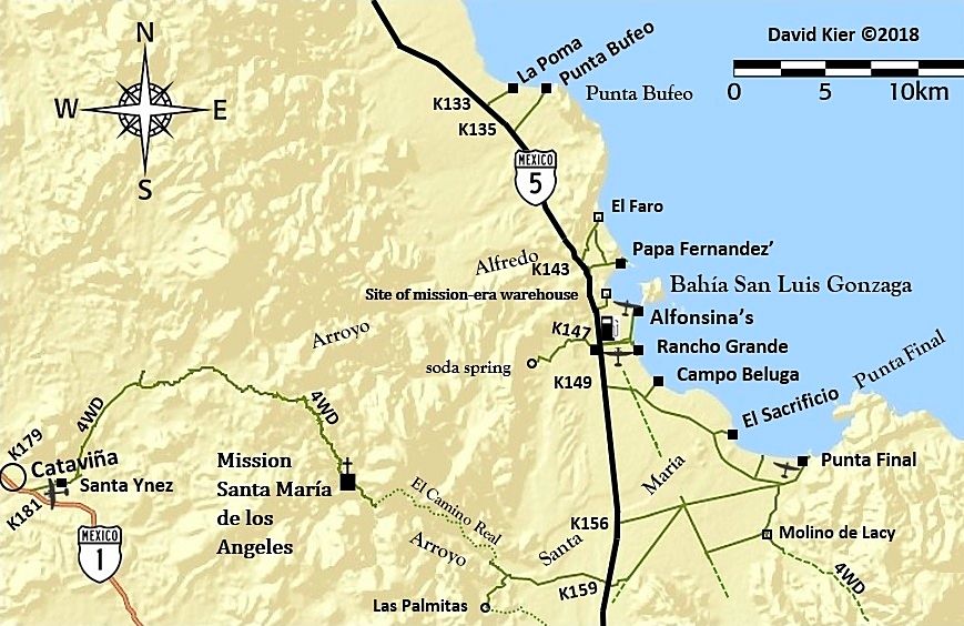
I didn't treat the same road further south the same, but did put 4WD next to it by the Pioneer Mine.
|
|
|
David K
Honored Nomad
Posts: 64478
Registered: 8-30-2002
Location: San Diego County
Member Is Offline
Mood: Have Baja Fever
|
|
The 25 maps in their first edition are posted in the Road Conditions forum: http://forums.bajanomad.com/viewthread.php?tid=88771
|
|
|
marv sherrill
Nomad
Posts: 456
Registered: 11-18-2003
Member Is Offline
|
|
David - will these be available in AAA type maps - all one piece? They are really nice and distinct!
|
|
|
David K
Honored Nomad
Posts: 64478
Registered: 8-30-2002
Location: San Diego County
Member Is Offline
Mood: Have Baja Fever
|
|
Hi Marv, my plan is that they will be inside the Baja Bound Road Guide to supplement my road logs. The maps are not very stand alone without mileage
figures on the dirt roads, in my opinion. The maps don't even show all of Baja, just some areas I think they are most useful. San Quintín, Santa
Rosalía, Puertecitos, Magdalena Bay are some places I have not (yet) made a map to show.
If you go to the thread were the maps all are now, I outline my idea for that.
Thank you for your comments!
I still miss the Baja Calendar you made for so many years, very much!
Here is where the maps are all together, now: http://forums.bajanomad.com/viewthread.php?tid=88771
|
|
|
steekers
Nomad
Posts: 255
Registered: 12-4-2007
Member Is Offline
|
|
| Quote: Originally posted by David K | OK, well... having refined my work using these 'caveman methods' on the computer (yes, I have heard Photoshop is a whole lot easier, etc.)... Here is
my new version of the Gonzaga Bay area map. Which was one of my first areas to do over a month ago... Please, your reviews:
Remember, what is on the map is limited by what is mentioned in the roadguide. Mileages along the dirt roads are in the roadguide so as to not clutter
up the map too much. The maps are to complement the roadguide so the reader can "see" where places in the guide text are, in relation to other places.
I hope to have newer samples of the roadguide for you to see soon, following all the editing since the previous version I have shared here.
|
David: Using Google Earth on an IPad, I notice the name "Oasis Santa Maria o Pozo la Escuadra" in green font and don't see it on your map. This
watering hole is quite the place for swimming but looks like a hike is needed. If you click on the green type and open up the photos, you see some
jeeps as if they made it all the way from Hwy 5 wash entry. Seems rather impossible for those jeeps to climb over the boulders.
|
|
|
David K
Honored Nomad
Posts: 64478
Registered: 8-30-2002
Location: San Diego County
Member Is Offline
Mood: Have Baja Fever
|
|
The road going west at Km. 159 is the access to Pozo Escuadra from Hwy. 5. You can drive to where the solid line ends on my map (and the El Camino
Real heads north)... Hike up the canyon the ~2-3 miles to that oasis.
I didn't hike all the way... When I found a pool big enough, that's where I took a dip! >>>

We arrive at the Santa Maria 'river' where it disappears beneath the sands.

Year-round refreshment in the lower Santa Maria canyon. The surrounding barren desert gives no clue to the quantity of water found here.
You can also get to Pozo Escuadra from Mission Santa María by using the washed out road to the canyon rim look-out, then hiking down the "Indian
Trail" (also the first El Camino Real route 1767-1769). See the aerial photo I took of it in 1999:

It isn't in my road guide because no road goes to it and it is best done on a backpacking adventure. There are other pools with palms along Arroyo
Santa María, too.
|
|
|
| Pages:
1
..
3
4
5 |


