| Pages:
1
2
3
4
5 |
David K
Honored Nomad

Posts: 64478
Registered: 8-30-2002
Location: San Diego County
Member Is Offline
Mood: Have Baja Fever
|
|
Quote: Originally posted by MulegeAL  | DK,
Does your road guide have info on road conditions such as high clearance, sand, etc? I have traveled most of your "little green lines" (as it is my
passion as well) and know maps are just a place to start with being prepared.
My concern is that these maps will wind up as screen dump printouts in rental cars, and maps can't show all the data for a green line adventure.
Maybe more dashed green lines would help where there are rough steep passes or lots of washouts like on the middle "road" east of the El Datil Salina
road. Bailout info is hard-won, not sure how to show that, maybe in your guide. The green lines in my locale have taken another beating from storms
and have even more rocks and ruts than last season.
I still see travelers in the interior with nothing more than AAA map and they were having a good time/came out alive.
Last month I ran copy of the Almanac for two bicycle riders who had no idea of the topography ahead, only a waypoint list and something on a solar
powered GPS. They were asking me if they could find water to filter in the Comondus routes.
Nice maps, keep them coming, thanks! |
Hi Al,
The maps are not the guide, but are to show what roads and places are in the guide, to better orient the reader.
The guidebook is written to describe the road and places along it or at the end of it. The guide is a preview of what one may find if the road is
driven. Too many zoom down Highway 1 (or 5) with an end destination in mind without know that a whole world of adventure and beauty is off on one of
the many roads most have no idea go to. I have been guilty of passing by many roads to get to my destination. Producing the guide, I traveled these
side roads for the first time to see what was at the end and I share that as well as the many places I have been to before.
The guide is a road log using kilometer markers along roads that have them, and the odometer on roads that don't. Photos of locations are included and
now, I am working on the maps to give some visual aid to show the reader where these roads are in relation to each other.
Perhaps I will post a sample of the road log someday soon? It is basically finished and has been copy-edited by more than one Baja author.
If you read my Baja Bound newsletter articles, you get a hint of some of the road log info. I wrote about the drive up to Mission Guadalupe (west from
Mulegé), recently. See the Nomad Baja Travel Articles forum:http://forums.bajanomad.com/forumdisplay.php?fid=45
The maps have a "4WD" note along any roads I consider it prudent to have four-wheel drive because of deep ruts, steep grades, silt beds, etc.
There is still lots to be done and I enjoy the opportunity to improve on what I have done so far. Thank you.
EDIT: Here are a couple sample pages from the San Felipe to Punta San Francisquito chapter (this is an early draft, it may have been edited more):

[Edited on 12-30-2017 by David K]
|
|
|
4x4abc
Ultra Nomad
Posts: 4163
Registered: 4-24-2009
Location: La Paz, BCS
Member Is Offline
Mood: happy - always
|
|
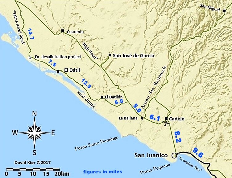
where is cuarenta Mesa?
Harald Pietschmann
|
|
|
David K
Honored Nomad
Posts: 64478
Registered: 8-30-2002
Location: San Diego County
Member Is Offline
Mood: Have Baja Fever
|
|
Not on the San Ignacio map, above... It could be added into the San Juanico map.
However, as I mentioned, these maps are to illustrate roads and places mentioned in the guide. To flood too much detail into these maps could render
them less than effective. The Cuarenta Mesa is not in my guide... but the Salina Mesa is (at least that is what the topo map calls the mesa north of
Rancho Cuarenta).
Rancho Cuarenta is in the next map...
|
|
|
David K
Honored Nomad
Posts: 64478
Registered: 8-30-2002
Location: San Diego County
Member Is Offline
Mood: Have Baja Fever
|
|
Would anyone like to see mileage figures next to the roads (the ones I logged)? I could do a test and see how that looks. It will either enrich the
map or clutter it up. Some of the maps have a lot of points so I wouldn't add mileages to them. However, it may be odd to have mileages only on some
maps...
|
|
|
John M
Super Nomad
Posts: 1906
Registered: 9-3-2003
Location: California High Desert
Member Is Offline
|
|
clutter
It will add clutter - and as you've said a number of times, the maps are meant to be used with the log (Guide) anyway - so there you have the
mileages. If you do go for a test look, make the numbers in some off the wall color. - Then will you have to label it in Kms. or Miles?
John M
|
|
|
David K
Honored Nomad
Posts: 64478
Registered: 8-30-2002
Location: San Diego County
Member Is Offline
Mood: Have Baja Fever
|
|
| Quote: Originally posted by John M | It will add clutter - and as you've said a number of times, the maps are meant to be used with the log (Guide) anyway - so there you have the
mileages. If you do go for a test look, make the numbers in some off the wall color. - Then will you have to label it in Kms. or Miles?
John M |
Valid point. A printed Guide will likely be in black & white, so colors won't do a thing. Fonts can, however. The only thing in kilometers are the
posts on highways... all the dirt roads have odometer mileages. If a dirt road has kilometer posts, then I include them as a reference point with the
mileage figures.
The auto club maps were great because they had mileages along every road shown... and they got the location spelling correct (lol)!
The Almanac has both miles (11.3m) and kilometers (18.2k) on selected roads. Did 4x4abc send a letter to Landon for using k and not Km. ?? 
|
|
|
David K
Honored Nomad
Posts: 64478
Registered: 8-30-2002
Location: San Diego County
Member Is Offline
Mood: Have Baja Fever
|
|
| Quote: Originally posted by John M | It will add clutter - and as you've said a number of times, the maps are meant to be used with the log (Guide) anyway - so there you have the
mileages. If you do go for a test look, make the numbers in some off the wall color. - Then will you have to label it in Kms. or Miles?
John M |
What I can do, is for future Baja Nomad posts, and not the Guide, is have maps with miles along the roads in question. I can easily edit the map on
Photo bucket with miles in bright red or blue along roads.
|
|
|
David K
Honored Nomad
Posts: 64478
Registered: 8-30-2002
Location: San Diego County
Member Is Offline
Mood: Have Baja Fever
|
|
Just an experiment... yes, the font size is not the same.
|
|
|
4x4abc
Ultra Nomad
Posts: 4163
Registered: 4-24-2009
Location: La Paz, BCS
Member Is Offline
Mood: happy - always
|
|
I like the miles along the road
still don't know where cuarenta Mesa is
Harald Pietschmann
|
|
|
mtgoat666
Select Nomad
Posts: 17288
Registered: 9-16-2006
Location: San Diego
Member Is Offline
Mood: Hot n spicy
|
|
It is where the treasure is hidden. Ssshhhhhhhhh!
Woke!
“...ask not what your country can do for you – ask what you can do for your country.” “My fellow citizens of the world: ask not what America
will do for you, but what together we can do for the freedom of man.”
Prefered gender pronoun: the royal we
|
|
|
MulegeAL
Nomad
Posts: 298
Registered: 8-25-2009
Location: PDX/Mulege
Member Is Offline
|
|
DK,
Thanks for the edit, I think that is fantastic stuff!
But,... Oh man, you need to go do the "High road" section again. It is soo bad! Many many washouts. We were in 4WD for a few twisty moondust
sections.
And Rancho Cuarenta, what a hoot! I missed the "highway" gate just outside the rancho, drove into the rancho. The old guy pulls out his 4 language
nota asking for pesos, doesn't say a word. I gave him 100P and he opened the gate!
But that road is seriously messed up. Dashed green line IMHO!
Edit:
The so called shortcut over the hill to Cadje...the climbs and descent over that mesa are 4wd. The rest of it is just rough! Possible deep water
hole at the Raymundo side depending on the season.
[Edited on 12-31-2017 by MulegeAL]
|
|
|
David K
Honored Nomad
Posts: 64478
Registered: 8-30-2002
Location: San Diego County
Member Is Offline
Mood: Have Baja Fever
|
|
Thanks for the road notes. I was wondering if I should add '4WD' to the east road to Mulegé via San Miguel. I drove the east half last summer going
to Mission Guadalupe.
I did not drive the high road other than the part with mileage notes. Where I did, it was wonderful. Exactly where did it go to hell... near Cuarenta?
It sure appeared to be the main 'highway' and more used than the Salina road.
[Edited on 12-31-2017 by David K]
|
|
|
MulegeAL
Nomad
Posts: 298
Registered: 8-25-2009
Location: PDX/Mulege
Member Is Offline
|
|
I agree, the sections where you show blue milage figures are no big problema.
The part we found roughest was from about La Salatilla drainage north almost all the way to rancho Cuarenta. Flooding washed out the road bed at
almost all the minor arroyos, forcing detours off the road that were moondust holes.
We were driving a lifted F250 4WD van on 33 BFGs, plowed the drop ins and climb outs with the hitch steel on a few of them. Doable, but can't
recommend as "Subaru-safe" route due to clearance requirements.
The "straight section north of Cuarenta along the flank of the mesa was overgrown with brush and trees, fold in the mirrors, expect to buff out the
sides of your ride from bushwacking.
Re: the San Raymundo route: not sure what to advise. This route get driven every day by 2WD locals and a few tourists, as it shows on the AAA map.
Lots more arroyo rock last couple of years. If dry, is long and rough 2WD, if wet, the climbs will be problematic 4WD.
Last season I encountered 3 young guys riding through on mountain bikes. Two were doing OK, the 3rd was having no fun at all, they were having to
push their loaded bikes through the sand then ride the arroyo rocks in the hot sun. To each his own I guess!
I went up to the Guadelupe junction last week, the west side has a lot more water than the east side at this point in time. Will report back when I
ride through to Cadeje/San J next couple of weeks, need more daylight in the day!
|
|
|
AKgringo
Elite Nomad
Posts: 5805
Registered: 9-20-2014
Location: Anchorage, AK (no mas!)
Member Is Offline
Mood: Retireded
|
|
Arroyo San Raymundo
It has been a year since I drove that route from Mulege to San Juanico, but unless there has been some road construction in the mean time, it does not
deserve the solid green road status!
It appears that instead of many crossings to graded roads on high ground next to the arroyo, they just bulldozed a trail right up the drainage. It
was slow, and brutal in my little 4x4 with 225/75/15 tires.
The only time I needed four wheel drive was when I got high centered on a rock trying to avoid an extra deep crossing, but clearance was a problem in
quite a few spots.
It could be better, or worse by now, but as of last Thanksgiving the western end of that route was no fun!
edit; I don't want to get too far off track with this post. If this is not the right time and place for feedback, send a U2U and I will delete this.
[Edited on 12-31-2017 by AKgringo]
If you are not living on the edge, you are taking up too much space!
"Could do better if he tried!" Report card comments from most of my grade school teachers. Sadly, still true!
|
|
|
David K
Honored Nomad
Posts: 64478
Registered: 8-30-2002
Location: San Diego County
Member Is Offline
Mood: Have Baja Fever
|
|
Thank you, MulegeAl and AKgringo. I think I will add a 4WD note on the San Raymundo road... Better safe than sorry!
As for the high road, I am sure surprised as the sections north and south of the Salina road junctions were a dirt highway and very well graded. If
you didn't know to go through El Dátil, there is nothing to alert you to not use the high road. It seemed (last August) that the main traffic flow
goes that way and the El Dátil route is a local fish camp road and not the preferred north/south road???
Happy New Year!
|
|
|
MulegeAL
Nomad
Posts: 298
Registered: 8-25-2009
Location: PDX/Mulege
Member Is Offline
|
|
DK,
Hard to judge at the Salina road junction based on wear marks. Farther up we stayed with the high road as the locals we were following peeled off To
El Patrocino. I asked the locals about the road to El P and they said it was OK. They were driving a classic beat up Ford Ranger, loaded.
So naturally we took the other way that was washed out!
Last season we saw lots of traffic on the low road, we were camped just north of El Datil. IMHO, if it's not wet, that is the way to go. If it was
wet, I'd try the route through El Patrocino next time.
I concur with AK's assessment of the San Raymundo route. It's hard for me to stay up on the pegs for the long arroyo rock sections. The fast easy
dirt sections that were there for most of that road 10/12 years ago are long gone.
I started taking the "shortcut" over the mesa to Cadeje a few years ago, but it is now way rough too. Still great fun (for me), and it puts me close
to rancho pals up towards La Vinorama.
I just went through my forks, the back roads here unscrewed the damper rod on one side, so the bars were jumping up and down as much as my front
wheel!
|
|
|
TMW
Select Nomad
Posts: 10659
Registered: 9-1-2003
Location: Bakersfield, CA
Member Is Offline
|
|
Maybe the road is better maintained to San Jose de Gracia but not thru to El Cuarenta and further north. The Last time I was at El Cuarenta Martin
said the road north was in very bad shape and told us to go west where we could pick up the road north of El Datil and we did.
|
|
|
David K
Honored Nomad
Posts: 64478
Registered: 8-30-2002
Location: San Diego County
Member Is Offline
Mood: Have Baja Fever
|
|
San Juanico Map-2
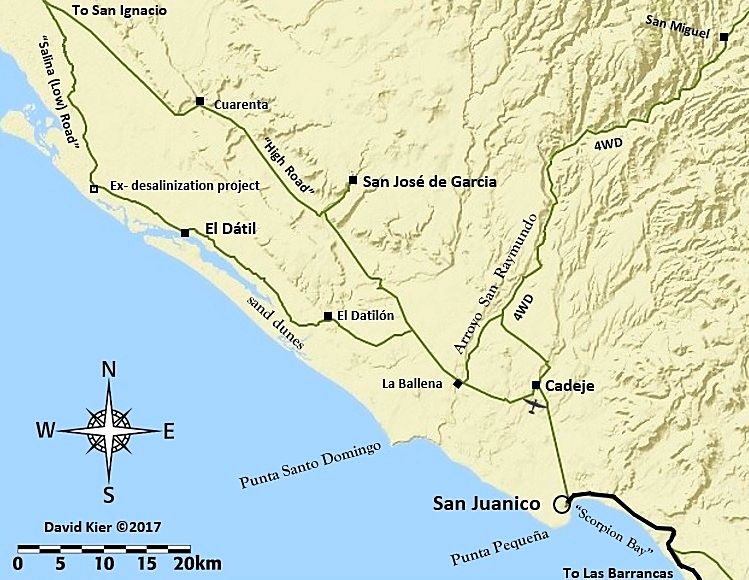
OK, I added 4WD on the San Raymundo road and To San Ignacio and Las Barrancas on the edges, for those routes. Also, made the airplane icon smaller and
touched up the paved road some.
|
|
|
David K
Honored Nomad
Posts: 64478
Registered: 8-30-2002
Location: San Diego County
Member Is Offline
Mood: Have Baja Fever
|
|
Thanks guys...
I think I am done with this one... As I did not drive the El Patrocinio road I am hesitant to show the road from there to Cuarenta. I am showing the
roads that I am because they were either driven and logged by me or I mentioned them in the guide. While I would love to show more, that may just
confuse the easy-to-read map view for the guide? IF I ever do the next Baja Almanac, then I want to know all these roads you have traveled and I want
to travel, too.
Happy New Year!
I will be making the next map while most of you are at parties! My esposa is visiting her mother in Henderson and hopes to see the fireworks above
Vegas tonight. I am home with our cats!

|
|
|
David K
Honored Nomad
Posts: 64478
Registered: 8-30-2002
Location: San Diego County
Member Is Offline
Mood: Have Baja Fever
|
|
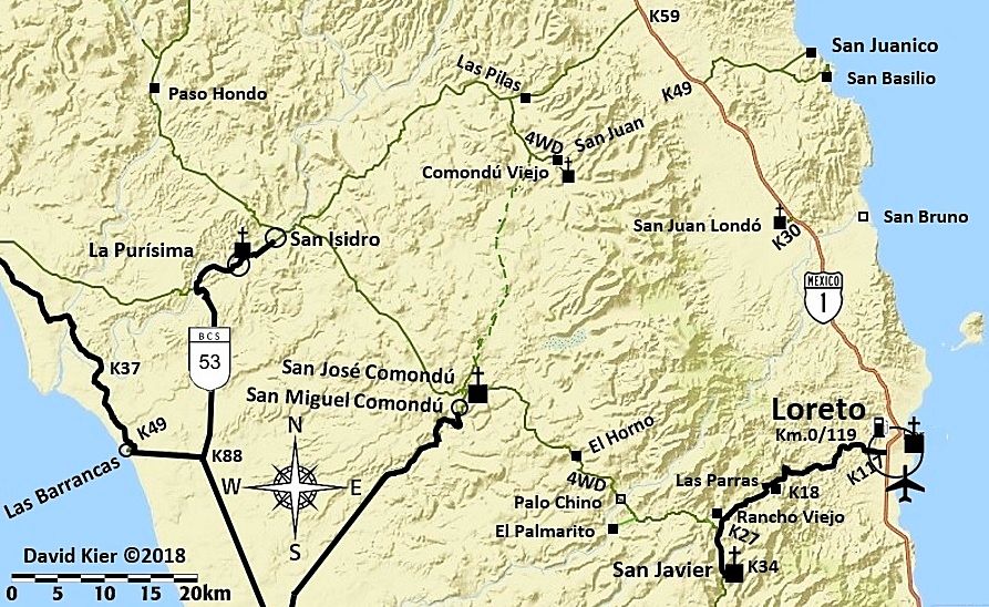
First Map of 2018
Happy New Year!
|
|
|
| Pages:
1
2
3
4
5 |


