| Pages:
1
2
3 |
Mjd78
Junior Nomad

Posts: 27
Registered: 1-2-2018
Member Is Offline
|
|
La Rumorosa road used in Licence to Kill
Hi all, I’m a James Bond fan and license to kill is one of my favorite movies. It was filmed in 1988 along the rumorosa pass, which apparently was
rerouted and reconstructed right around then. The movie was shot on the old part of the highway. I’m going to do the drive in about a month, and
wanted to know if anyone knew which road they used and how I could access it. I also am fascinated by this road and want to learn more about it...when
it was built, renovated, where the original portions were that were bypassed...etc. Any information anyone has would be greatly appreciated. Thanks a
ton!
|
|
|
StuckSucks
Super Nomad
Posts: 2375
Registered: 10-17-2013
Location: Pacific Plate
Member Is Offline
|
|
Is this it? The tanker truck scene? The truck looks like the old Pemex paint scheme. The rocks look about right ...
|
|
|
mtgoat666
Platinum Nomad
Posts: 20790
Registered: 9-16-2006
Location: San Diego
Member Is Offline
Mood: Hot n spicy
|
|
Quote: Originally posted by Mjd78  | | Hi all, I’m a James Bond fan and license to kill is one of my favorite movies. It was filmed in 1988 along the rumorosa pass, which apparently was
rerouted and reconstructed right around then. The movie was shot on the old part of the highway. I’m going to do the drive in about a month, and
wanted to know if anyone knew which road they used and how I could access it. I also am fascinated by this road and want to learn more about it...when
it was built, renovated, where the original portions were that were bypassed...etc. Any information anyone has would be greatly appreciated. Thanks a
ton! |
License to ill, way better than license to kill 
If you like chick flicks, titanic was filmed over the hill is Rosarito 
Use google earth to see the rumorosa grade.
But seriously,....David K has been collecting baja road construction notes since 1967, he will along shortly to share photos of he and his suby on the
road in 1978. He probably has a photo album of his dad driving the old jeep wagoner down rumorosa grade, photos from long before Timothy dalton was
born.
Woke!
Hands off!
“Por el bien de todos, primero los pobres.”
“...ask not what your country can do for you – ask what you can do for your country.” “My fellow citizens of the world: ask not what America
will do for you, but what together we can do for the freedom of man.”
Pronoun: the royal we
|
|
|
gnukid
Ultra Nomad
Posts: 4411
Registered: 7-2-2006
Member Is Offline
|
|
We can't tell you cause its a secret
|
|
|
DavidT
Nomad
Posts: 494
Registered: 4-9-2005
Member Is Offline
|
|
Never thought I'd see a Beastie Boys reference on BajaNomad.

David
Not one shred of evidence supports the notion that life is serious.
|
|
|
Mjd78
Junior Nomad
Posts: 27
Registered: 1-2-2018
Member Is Offline
|
|
Ya it looks like the ashpLt becomes a dirt road. And license to Ill is a rad record! I’ll play it when I go there! 🤙🏻
|
|
|
Mjd78
Junior Nomad
Posts: 27
Registered: 1-2-2018
Member Is Offline
|
|
That’s it. It’s supposed to be filmed on an abandoned part of the highway
|
|
|
TMW
Select Nomad
Posts: 10659
Registered: 9-1-2003
Location: Bakersfield, CA
Member Is Offline
|
|
The original paved road is what is now the down hill side. It was both up hill and down hill two lanes before the new section was built going up hill.
Of course the original dirt road may be the old dirt road just to the south that is still usable and has been used by SCORE in some of the Baja 500
and 1000 races.
I read a paper several years ago that told all the details of how and when the paved road was built. I think it was in a newsletter that Discover Baja
put out. A very interesting read.
|
|
|
Mjd78
Junior Nomad
Posts: 27
Registered: 1-2-2018
Member Is Offline
|
|
| Quote: Originally posted by TMW | The original paved road is what is now the down hill side. It was both up hill and down hill two lanes before the new section was built going up hill.
Of course the original dirt road may be the old dirt road just to the south that is still usable and has been used by SCORE in some of the Baja 500
and 1000 races.
I read a paper several years ago that told all the details of how and when the paved road was built. I think it was in a newsletter that Discover Baja
put out. A very interesting read. |
That sounds like a very interesting read. So the eastbound lanes are the original roads...good to know. Thanks for the info.
|
|
|
Maderita
Senior Nomad
Posts: 695
Registered: 12-14-2008
Location: San Diego
Member Is Offline
|
|
It appears that License to Kill was filmed on what was at the time a free 'libre" road. It was all asphalt, two lanes. Notorious for fatal accidents.
The canyon below was littered with the remains of cars and trucks which had gone over the edge.
"Rumorosa grade" is a common name for Cuesta de Cantú or Cantú Grade, named for a former governor of the territory of Baja California.
La Rumorosa was called "Alaska" many decades ago.
Looks to me that most of the filming was at the higher elevations with domes and huge granitic boulders, elevation 3,000'+.
The new toll highway ("cuota") is now Mex Highway 2D. The free road was Mex 2 and no longer exists between La Rumorosa and the desert.
https://en.wikipedia.org/wiki/Mexican_Federal_Highway_2D
When in the area, you might check out Casa de Piedra and its "mirador" (viewpoint). Park 1/4 mile east of the toll booth (caseta de cobro) on the east
end of La Rumorosa. It's easy to miss, so go slow. There may be some banner/flags. Drive in a steep driveway or park next to the highway. My friend
Alfredo Vizcarra owns it and charges a few pesos entrance fee. Nice picnic spot.
Or lunch at Cabana del Abuelo, on the free road west side of town, next door to the Pemex station.
An interesting side trip is Vallecitos natural park which has Native American cave paintings. West of La Rumorosa on the cuota, exit at KM68, drive
north on graded dirt road approx 1/2 mile. Entrance is a couple dollars with safe parking. A self-guided loop trail takes approx. 45 minutes. 2 hours
if you relax and take a lot of photos.
[Edited on 1-3-2018 by Maderita]
|
|
|
ehall
Super Nomad
Posts: 1906
Registered: 3-29-2014
Location: Buckeye, Az
Member Is Offline
Mood: It's 5 o'clock somewhere
|
|
| Quote: Originally posted by mtgoat666 |
But seriously,....David K has been collecting baja road construction notes since 1967, he will along shortly to share photos of he and his suby on the
road in 1978. He probably has a photo album of his dad driving the old jeep wagoner down rumorosa grade, photos from long before Timothy dalton was
born. |
Why are you such a dick?
|
|
|
Mjd78
Junior Nomad
Posts: 27
Registered: 1-2-2018
Member Is Offline
|
|
| Quote: Originally posted by Maderita | It appears that License to Kill was filmed on what was at the time a free 'libre" road. It was all asphalt, two lanes. Notorious for fatal accidents.
The canyon below was littered with the remains of cars and trucks which had gone over the edge.
"Rumorosa grade" is a common name for Cuesta de Cantú or Cantú Grade, named for a former governor of the territory of Baja California.
La Rumorosa was called "Alaska" many decades ago.
Looks to me that most of the filming was at the higher elevations with domes and huge granitic boulders, elevation 3,000'+.
The new toll highway ("cuota") is now Mex Highway 2D. The free road was Mex 2 and no longer exists between La Rumorosa and the desert.
https://en.wikipedia.org/wiki/Mexican_Federal_Highway_2D
When in the area, you might check out Casa de Piedra and its "mirador" (viewpoint). Park 1/4 mile east of the toll booth (caseta de cobro) on the east
end of La Rumorosa. It's easy to miss, so go slow. There may be some banner/flags. Drive in a steep driveway or park next to the highway. My friend
Alfredo Vizcarra owns it and charges a few pesos entrance fee. Nice picnic spot.
Or lunch at Cabana del Abuelo, on the free road west side of town, next door to the Pemex station.
An interesting side trip is Vallecitos natural park which has Native American cave paintings. West of La Rumorosa on the cuota, exit at KM68, drive
north on graded dirt road approx 1/2 mile. Entrance is a couple dollars with safe parking. A self-guided loop trail takes approx. 45 minutes. 2 hours
if you relax and take a lot of photos.
[Edited on 1-3-2018 by Maderita] |
Wow,thsnks?! So there’s no access to the free road (old highway 2)? Is there no turn off to that road? I’m going to follow all your suggestions,
sound like it would add on to my trip!
|
|
|
AKgringo
Elite Nomad
Posts: 6325
Registered: 9-20-2014
Location: Anchorage, AK (no mas!)
Member Is Offline
Mood: Retireded
|
|
I have used the "libremente" from Tecate to La Rumorosa, but I headed south from there to Laguna Hanson. I am pretty sure that there is no paved free
road down the mountain from there, but there are several connections to the toll road between the pass and Ensenada.
Where would you be coming from, Mexicali, or Tecate? I am interested in finding the dirt road up the pass from Mexicali, but I don't know where it
intersects with hwy 2 at the top.
I drove the toll road from the intersection with hwy 5 to Tecate last December. The spectacular climb was somewhat marred by pea soup fog on the top
third of the mountain!
If you are not living on the edge, you are taking up too much space!
"Could do better if he tried!" Report card comments from most of my grade school teachers. Sadly, still true!
|
|
|
Mjd78
Junior Nomad
Posts: 27
Registered: 1-2-2018
Member Is Offline
|
|
| Quote: Originally posted by AKgringo | I have used the "libremente" from Tecate to La Rumorosa, but I headed south from there to Laguna Hanson. I am pretty sure that there is no paved free
road down the mountain from there, but there are several connections to the toll road between the pass and Ensenada.
Where would you be coming from, Mexicali, or Tecate? I am interested in finding the dirt road up the pass from Mexicali, but I don't know where it
intersects with hwy 2 at the top.
I drove the toll road from the intersection with hwy 5 to Tecate last December. The spectacular climb was somewhat marred by pea soup fog on the top
third of the
mountain! |
I’m coming from Tecate and doing a day or two of exploring. I have a suv with 4wd and want to go a little off the beaten path.
|
|
|
StuckSucks
Super Nomad
Posts: 2375
Registered: 10-17-2013
Location: Pacific Plate
Member Is Offline
|
|
| Quote: Originally posted by Mjd78 | | I’m coming from Tecate and doing a day or two of exploring. I have a suv with 4wd and want to go a little off the beaten path.
|
Here's your "off the beaten path" route -- how about taking the old dirt Rumorosa Road down the hill?
|
|
|
Maderita
Senior Nomad
Posts: 695
Registered: 12-14-2008
Location: San Diego
Member Is Offline
|
|
Another side trip is to drive south from La Rumorosa to the Parque Nacional at Laguna Hanson (small scenic lake), approx 38 miles of dirt road. 2WD
except during and after winter storms. Elevations between 4,000' and 6,000' into the pine forests and granite crags of the Sierra de Juárez.
Perhaps visit Rancho el Topo, a working cattle ranch. Horseback riding is available at a reasonable price. Ricardo Sandoval is fluent in English and
welcomes visitors. A well-signed turnoff is just beyond the KM35 marker on that road.
https://www.facebook.com/RanchoElTopoSierraDeJuarez/
|
|
|
Maderita
Senior Nomad
Posts: 695
Registered: 12-14-2008
Location: San Diego
Member Is Offline
|
|
| Quote: Originally posted by AKgringo |
I am interested in finding the dirt road up the pass from Mexicali, but I don't know where it intersects with hwy 2 at the top.
|
AKgringo,
As I recall from 15 or 20 years ago, the dirt road leads to La Rumorosa. Going from La Rumorosa toward the desert, it's somewhat a maze of dirt roads.
You could probably just pick a general compass direction. Or preview it on Google Earth to plot your route.
[Edited on 1-3-2018 by Maderita]
|
|
|
Mjd78
Junior Nomad
Posts: 27
Registered: 1-2-2018
Member Is Offline
|
|
| Quote: Originally posted by StuckSucks | | Quote: Originally posted by Mjd78 | | I’m coming from Tecate and doing a day or two of exploring. I have a suv with 4wd and want to go a little off the beaten path.
|
Here's your "off the beaten path" route -- how about taking the old dirt Rumorosa Road down the hill?
 |
Yes! That looks awesome. How do I get there? I looked at google maps and there looks like a few different route, but I can’t trace them all the way
down the grade
|
|
|
David K
Honored Nomad
Posts: 65478
Registered: 8-30-2002
Location: San Diego County
Member Is Offline
Mood: Have Baja Fever
|
|
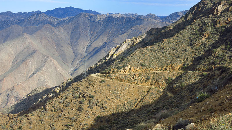
Use Google Earth to pre-plan your access. We were at La Rumorosa rest stop (just southwest of the toll gate) as Baja 1000 pre-runners were heading for
the dirt grade down the mountain passed by on the paved street alongside the highway rest stop bathroom building...
This photo is of the original Hwy. 2 heading to the Cantu Grade from La Rumorosa as seen from the rest stop... Nov. 2008.
In the 1960s, we did drive Hwy. 2 up the grade, once... never again on the old paved road. Many Mexicans back in the day would cross into the United
States at Calexico and drive U.S. Hwy. 80 (which became Interstate 8) and cross back at Tijuana until the current 4-lane highway in Mexico was
completed. That was before hours-long border waits became the norm after 9-11-2001.
|
|
|
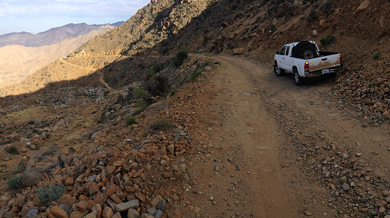
StuckSucks
Super Nomad
Posts: 2375
Registered: 10-17-2013
Location: Pacific Plate
Member Is Offline
|
|
| Quote: Originally posted by Mjd78 |
Yes! That looks awesome. How do I get there? I looked at google maps and there looks like a few different route, but I can’t trace them all the way
down the grade |
La Rumorosa Google Maps
If you have problems with high anxiety (thanks, Mel Brooks), you might want to avoid this road. In my Tacoma, several of the switchbacks required
multi-point turns. Drop down the switchbacks into the arroyo, then follow it to the toll road at the bottom. If you want, you can easily join the toll
road near the military checkpoint/new Pemex station.
|
|
|
| Pages:
1
2
3 |


