| Pages:
1
2
3 |
Mjd78
Junior Nomad

Posts: 27
Registered: 1-2-2018
Member Is Offline
|
|
Quote: Originally posted by StuckSucks  | | Quote: Originally posted by Mjd78 | | I’m coming from Tecate and doing a day or two of exploring. I have a suv with 4wd and want to go a little off the beaten path.
|
Here's your "off the beaten path" route -- how about taking the old dirt Rumorosa Road down the hill?
 |
Yes! That looks awesome. How do I get there? I looked at google maps and there looks like a few different route, but I can’t trace them all the way
down the grade
|
|
|
David K
Honored Nomad
Posts: 64479
Registered: 8-30-2002
Location: San Diego County
Member Is Offline
Mood: Have Baja Fever
|
|
Great map Stuck! If you zoom in at the Hwy. 2 symbol by the toll booth you can see how old highway 2 swung away to the edge of the mountain (my photo
above)... and out-of-sight it swings back north and is soon covered over by the new highway. The new highway downhill side seems to be built over the
old Highway 2 roadbed.
|
|
|
Mjd78
Junior Nomad
Posts: 27
Registered: 1-2-2018
Member Is Offline
|
|
| Quote: Originally posted by StuckSucks | | Quote: Originally posted by Mjd78 |
Yes! That looks awesome. How do I get there? I looked at google maps and there looks like a few different route, but I can’t trace them all the way
down the grade |
La Rumorosa Google Maps
If you have problems with high anxiety (thanks, Mel Brooks), you might want to avoid this road. In my Tacoma, several of the switchbacks required
multi-point turns. Drop down the switchbacks into the arroyo, then follow it to the toll road at the bottom. If you want, you can easily join the toll
road near the military checkpoint/new Pemex station. |
Luckily I don’t get animus too easily, although i am a very careful driver. Is that road unpacked most of the way down? It looks like it is paved at
the top for a few miles before it looops back to the toll road and then there are dirt roads everywhere
|
|
|
StuckSucks
Super Nomad
Posts: 2305
Registered: 10-17-2013
Member Is Offline
|
|
| Quote: Originally posted by Mjd78 | | Is that road unpacked most of the way down? It looks like it is paved at the top for a few miles before it looops back to the toll road and then there
are dirt roads everywhere |
The dirt road down has nothing to do with the toll road. Once you leave the town of Rumorosa, the road is a single track road, hard pack, with varying
degrees of rocks. The road is narrow, so few places to pass should you see other traffic.
|
|
|
Mjd78
Junior Nomad
Posts: 27
Registered: 1-2-2018
Member Is Offline
|
|
| Quote: Originally posted by Mjd78 | | Quote: Originally posted by StuckSucks | | Quote: Originally posted by Mjd78 |
Yes! That looks awesome. How do I get there? I looked at google maps and there looks like a few different route, but I can’t trace them all the way
down the grade |
La Rumorosa Google Maps
If you have problems with high anxiety (thanks, Mel Brooks), you might want to avoid this road. In my Tacoma, several of the switchbacks required
multi-point turns. Drop down the switchbacks into the arroyo, then follow it to the toll road at the bottom. If you want, you can easily join the toll
road near the military checkpoint/new Pemex station. |
Luckily I don’t get anxious too easily, although i am a very careful driver. Is that road unpaved most of the way down? It looks like it is paved at
the top for a few miles before it looops back to the toll road and then there are dirt roads everywhere |
Thank you for highlighting that route!
[Edited on 1-3-2018 by Mjd78]
|
|
|
Mjd78
Junior Nomad
Posts: 27
Registered: 1-2-2018
Member Is Offline
|
|
| Quote: Originally posted by Maderita | Another side trip is to drive south from La Rumorosa to the Parque Nacional at Laguna Hanson (small scenic lake), approx 38 miles of dirt road. 2WD
except during and after winter storms. Elevations between 4,000' and 6,000' into the pine forests and granite crags of the Sierra de Juárez.
Perhaps visit Rancho el Topo, a working cattle ranch. Horseback riding is available at a reasonable price. Ricardo Sandoval is fluent in English and
welcomes visitors. A well-signed turnoff is just beyond the KM35 marker on that road.
https://www.facebook.com/RanchoElTopoSierraDeJuarez/ |
Thank you for all your suggestions! I’ll add those on my list in addition to trying to find the road where License to Kill was filmed!!
|
|
|
Mjd78
Junior Nomad
Posts: 27
Registered: 1-2-2018
Member Is Offline
|
|
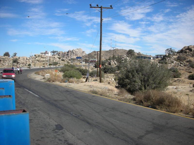
| Quote: Originally posted by David K | Use Google Earth to pre-plan your access. We were at La Rumorosa rest stop (just southwest of the toll gate) as Baja 1000 pre-runners were heading for
the dirt grade down the mountain passed by on the paved street alongside the highway rest stop bathroom building...
This photo is of the original Hwy. 2 heading to the Cantu Grade from La Rumorosa as seen from the rest stop... Nov. 2008.
In the 1960s, we did drive Hwy. 2 up the grade, once... never again on the old paved road. Many Mexicans back in the day would cross into the United
States at Calexico and drive U.S. Hwy. 80 (which became Interstate 8) and cross back at Tijuana until the current 4-lane highway in Mexico was
completed. That was before hours-long border waits became the norm after 9-11-2001. |
So it was that much crazier before? I know it was a two lane highway and that trucks could slow things down, but it sounds like the same road that
exists now was (eastbound) is the same road that was used before, only I’m sure the road was narrower with less guard failed, sharper turns and had
oncoming traffic. The licence to Kill documentary said that they used part of the road that was bypassed because it was the most dangerous part, where
apparently a majority of the cars would fall and the part they thought was haunted. I don’t know how much of what they said in the documentary is
true or if they are embellishing, but they thought part of the toll highway was rerouted from the old highway in at least one spot.
|
|
|
David K
Honored Nomad
Posts: 64479
Registered: 8-30-2002
Location: San Diego County
Member Is Offline
Mood: Have Baja Fever
|
|
Well, if it is still there, then you will see it on satellite images. I just noticed that just around the corner from my photo the old road seem to go
right into the downhill lanes of the new road... As you can see the grade up and using a different route than the grade down, now.
Perhaps, they closed the downhill grade for filming? I just don't see any other paved roads going down the mountain beside the new highway.
|
|
|
Mjd78
Junior Nomad
Posts: 27
Registered: 1-2-2018
Member Is Offline
|
|
| Quote: Originally posted by David K | Well, if it is still there, then you will see it on satellite images. I just noticed that just around the corner from my photo the old road seem to go
right into the downhill lanes of the new road... As you can see the grade up and using a different route than the grade down, now.
Perhaps, they closed the downhill grade for filming? I just don't see any other paved roads going down the mountain beside the new highway.
|
I agree. Thanks for all your help. Looks like quite an adventure!
|
|
|
Mjd78
Junior Nomad
Posts: 27
Registered: 1-2-2018
Member Is Offline
|
|
| Quote: Originally posted by StuckSucks | | Quote: Originally posted by Mjd78 | | Is that road unpacked most of the way down? It looks like it is paved at the top for a few miles before it looops back to the toll road and then there
are dirt roads everywhere |
The dirt road down has nothing to do with the toll road. Once you leave the town of Rumorosa, the road is a single track road, hard pack, with varying
degrees of rocks. The road is narrow, so few places to pass should you see other traffic. |
Is that road where all the accidents occurred? That road looks pretty crazy but adventurous
|
|
|
David K
Honored Nomad
Posts: 64479
Registered: 8-30-2002
Location: San Diego County
Member Is Offline
Mood: Have Baja Fever
|
|
All the accidents were on the original paved Hwy. 2 road, replaced by the divided (2 lanes up/2 lanes down) toll highway... There are still MANY
accidents on it... primarily cargo trucks going over the side!
|
|
|
TMW
Select Nomad
Posts: 10659
Registered: 9-1-2003
Location: Bakersfield, CA
Member Is Offline
|
|
The turn off for the dirt road down the mountain is at
32-33.13x116-02.51

Bear right onto the dirt road down 32-33.13x116-01.99

[Edited on 1-3-2018 by TMW]
|
|
|
Mjd78
Junior Nomad
Posts: 27
Registered: 1-2-2018
Member Is Offline
|
|
| Quote: Originally posted by David K | | All the accidents were on the original paved Hwy. 2 road, replaced by the divided (2 lanes up/2 lanes down) toll highway... There are still MANY
accidents on it... primarily cargo trucks going over the side! |
That’s nuts! How does this road compare to the 8 east of Jacumba in the us? I take that to work about once a week from San Diego. Beautiful drive.
|
|
|
David K
Honored Nomad
Posts: 64479
Registered: 8-30-2002
Location: San Diego County
Member Is Offline
Mood: Have Baja Fever
|
|
Not even close... but compared to the 2 lane road it replaced 2-D is much better... as you can pass all the slow trucks.
I-8 is high-speed freeway top to bottom.
2-D has several sharp turns, and being 2-lanes in each direction, allows you to cut across for the curves IF the lane is free. Now, it is fine for all
cars to use... and I use it a lot since I only cross at Tecate and usually use Hwy. 5 in Baja for getting south/north.. so I must use 2-D to get from
Hwy. 5 over to Tecate the fastest.
|
|
|
ehall
Super Nomad
Posts: 1906
Registered: 3-29-2014
Location: Buckeye, Az
Member Is Offline
Mood: It's 5 o'clock somewhere
|
|
Lots of videos on youtube. Mostly street bikes.
|
|
|
Mjd78
Junior Nomad
Posts: 27
Registered: 1-2-2018
Member Is Offline
|
|
| Quote: Originally posted by TMW | The turn off for the dirt road down the mountain is at
32-33.13x116-02.51
Bear right onto the dirt road down 32-33.13x116-01.99
[Edited on 1-3-2018 by TMW] |
Thanks a lot!
|
|
|
PaulW
Ultra Nomad
Posts: 3005
Registered: 5-21-2013
Member Is Offline
|
|
Use care there is now a big rock blocking the way. Three rigs went down one had fender damage. The other two spotted and made it clear.
|
|
|
Mjd78
Junior Nomad
Posts: 27
Registered: 1-2-2018
Member Is Offline
|
|
| Quote: Originally posted by PaulW | | Use care there is now a big rock blocking the way. Three rigs went down one had fender damage. The other two spotted and made it clear.
|
I will, if I can’t get on the toll road from there, I’ll at least take the dirt roads for a little as I explore
|
|
|
StuckSucks
Super Nomad
Posts: 2305
Registered: 10-17-2013
Member Is Offline
|
|
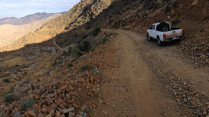
Here's what some of dirt Rumorosa looks like -- not a good place to get complacent.
|
|
|
mtgoat666
Select Nomad
Posts: 17290
Registered: 9-16-2006
Location: San Diego
Member Is Online
Mood: Hot n spicy
|
|
Don’t worry about impassable old roads, you wont miss much if you can’t drive them, the scenery/topography is similar on paved road.
If you want to have a real adventure and see what everyone misses, then park along the highway or old road, amongst the boulder piles, and
hike/scramble up a peak or ridge — the views are much more spectacular if you get high above the road atop the ridges and peaks — people on the
road got no idea what they are missing. This is a good time of year to hike when weather is cool.
Woke!
“...ask not what your country can do for you – ask what you can do for your country.” “My fellow citizens of the world: ask not what America
will do for you, but what together we can do for the freedom of man.”
Prefered gender pronoun: the royal we
|
|
|
| Pages:
1
2
3 |


