WideAngleWandering
Nomad

Posts: 390
Registered: 3-13-2012
Location: US-Based but traveling
Member Is Offline
|
|
Baja 2018 Cactus-Whales-Tecate Roadtrip Questions
Howdy all,
We're leaving next week for our annual baja roadtrip. We've got two vehicles (a newish Jeep SUV and an older diesel Land Cruiser), 5 people, and 1
small dog. Halfway through the Jeep (with dog and 3 of the group) will turn back and two of us will wander some more.
Here's our rough plan and questions. We'll probably wing it / deviate quite a bit along the way. Still, I like to plan a route in my head. Half the
fun is thinking about the trip.
Day 1 - cross in TJ and overnight in Ensenada.
Day 2 - One night in Cañón de Guadalupe. I usually shy away from this spot, even though it's awesome, because the high prices, glamping, and
weird history of how they took it over. But I've got a couple people with me who've never been there so we'll probably go and enjoy the pools.
Is the Oasis the best bet to camp?
Day 3 - Party on the San Felipe malecón. Is Danny Clamato still in business?
Day 4 - Drive south and camp a night at Punta Final. Worth it to do a bit of shore fishing here or elsewhere? What would I
bring? I know how to cast lures and entertain the fish with a spinning reel in a lake but never fished the ocean.
Day 5 - Drive to Ojo de Liebre for whale watching with Shari via Coco's and the Calamajue wash / arroyo trail. How's the trail this
year? I don't expect any trouble with either vehicle.
Day 7 - Camp along Bahia Concepcion. Not sure where yet. I have some GPS coordinates from a place we boondocked before and will probably head
there if it's quiet.
Day 8 - Adios to the Jeep and it's crew. Land Cruiser heads to San Ignacio.
Day 9 - Maybe more whales. I've never been to the lagoon at San Ignacio and I'm curious to see how the whales behave there.
Recommendations to stay near town or near Lagoon?
Day 10 - We start meandering north. First stop La Bocana. I've never stopped and have always meant to say hi to Blanca.
Recommendations on camping?
Day 12 - Ojo de Liebre again. Would have stayed longer on the way down but our Jeep friends were on a tighter schedule.
Day 14 - Punta Blanco or somewhere along the coast road for the 7 Sisters? Coco said great things about camping near Punta Blanco and the road
connecting hwy 1 to Punta Blanco and it's been circled on my map for a while. Recommendations for a beautiful remote spot to camp?
I promise not to disturb the surfers 
Day 16 - Playa La Gringa from Bahia de Los Angeles. I've never camped here.
Day 18 - Back to San Felipe via Chapala and Coco's. Warm shower.
Day 19 - Camp in the desert lake bed at Laguna Diablo. Get up early and watch the lunar eclipse. Last time I was here I had a bunch of fun
hanging out with the army guys. We gave them beer, they checked out my Land Cruiser and let me play with their Hummer. Maybe this year they'll let
me drive it and pop off a few rounds.
Day 20 - Cross in Mexicali and head back to the default world, with tacos and tecate in my belly and a happy thoughts of a wild and distant land
in my head.
Anybody on my route in need of anything? I can bring stuff from the states or pick things up along the way.
[Edited on 2018-1-7 by WideAngleWandering]
Traveling the Americas via my old land cruiser
|
|
|
David K
Honored Nomad
Posts: 64479
Registered: 8-30-2002
Location: San Diego County
Member Is Offline
Mood: Have Baja Fever
|
|
Wonderful list of places... but where is Baja Cactus (El Rosario) and Tecate fitting in (both in your subject title)?
With so many places, all I personally can offer is for you to look at my 7 trip reports of 2017, as I went to many of those places. They are all in
the Nomad Trip Reports forum, here: http://forums.bajanomad.com/forumdisplay.php?fid=50
|
|
|
WideAngleWandering
Nomad
Posts: 390
Registered: 3-13-2012
Location: US-Based but traveling
Member Is Offline
|
|
Edited the title to make it a bit more clear.
Cactus:
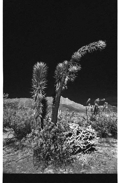
Cactus in the Valle de los Cirios by Wide-Angle Wandering, on Flickr
Whales:
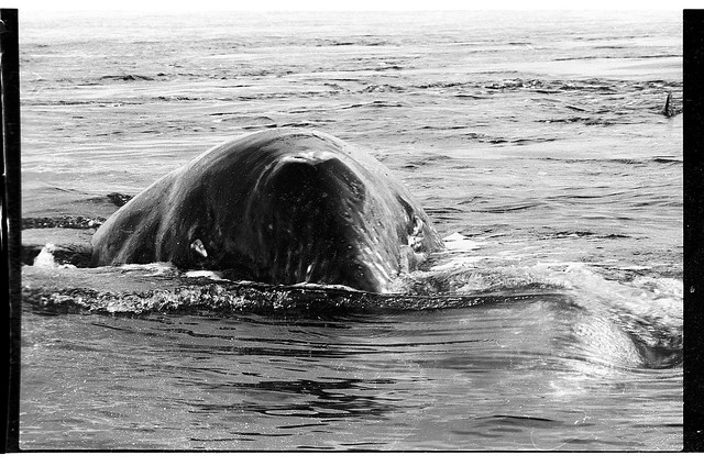
Coming Right For Us by Wide-Angle Wandering, on Flickr
Tecate:
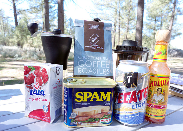
Breakfast by Wide-Angle Wandering, on Flickr

Traveling the Americas via my old land cruiser
|
|
|
David K
Honored Nomad
Posts: 64479
Registered: 8-30-2002
Location: San Diego County
Member Is Offline
Mood: Have Baja Fever
|
|
LOL, yes... good clarity now!
|
|
|
advrider
Super Nomad
Posts: 1847
Registered: 10-2-2015
Member Is Offline
|
|
#8- I have only stayed in town but always wondered about the cabins out at the coast where the whale watching is? I love the ride from El Arco back to
BOLA and I'm sure it would be an awesome drive, stop and have a beer with poncho....... Sounds like an awesome trip!
|
|
|
shari
Select Nomad
Posts: 13033
Registered: 3-10-2006
Location: bahia asuncion, baja sur
Member Is Offline
Mood: there is no reality except the one contained within us "Herman Hesse"
|
|
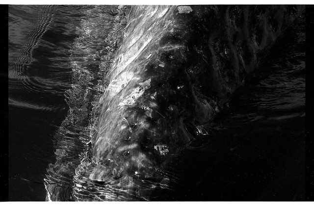
Oh that B&W of the calf's dimples is so amazing! Can't wait to chill with you guys.
Sirena will dial you into the hotsprings by Ensenada
.
|
|
|
WideAngleWandering
Nomad
Posts: 390
Registered: 3-13-2012
Location: US-Based but traveling
Member Is Offline
|
|
I have so many whale photos to share. Here's another from last year.
Grey Whale in Ojo de Liebre by Wide-Angle Wandering, on Flickr
The full Baja 2017 album: https://www.flickr.com/photos/wideanglewandering/albums/7215...
Traveling the Americas via my old land cruiser
|
|
|
TMW
Select Nomad
Posts: 10659
Registered: 9-1-2003
Location: Bakersfield, CA
Member Is Offline
|
|
["Day 14 - Punta Blanco or somewhere along the coast road for the 7 Sisters? Coco said great things about camping near Punta Blanco and the road
connecting hwy 1 to Punta Blanco and it's been circled on my map for a while. Recommendations for a beautiful remote spot to camp? I promise not to
disturb the surfers "]
Which road did Coco recommend using to get there? There is a rock outcropping at the mid-section and on the south side is a good place to camp. GPS
29-05.63x114-37.56
Check out this trip report.
http://forums.bajanomad.com/viewthread.php?tid=39975
There are two roads that go from Hwy 1 to Punta Blanco. KM 234 Near where you come out from Cocos at Laguna Chapala. It's fenced so check with the
Tire guy there or at the restaurant (blue bldg) on how to access it. Road is rough with lots of silt beds near the ocean. Go south as you near the
ocean. About 4 miles from hwy 1 is a dry lake and if it rains it may be covered with water. I'd be careful crossing with water on it. If you do cross
you want to go just to the right of a large black hill on the west side of the lake bed.
Best road is at KM252. Also silt beds after you come down the mountain. Be careful picking your lines. Go north as you near the ocean.
[Edited on 1-10-2018 by TMW]
|
|
|
WideAngleWandering
Nomad
Posts: 390
Registered: 3-13-2012
Location: US-Based but traveling
Member Is Offline
|
|
I can't remember the details, just that it was near the Laguna Chapala area. I figured I'd get better directions from him on this next trip, but your
layout may get me there. Thank you.
Traveling the Americas via my old land cruiser
|
|
|
David K
Honored Nomad
Posts: 64479
Registered: 8-30-2002
Location: San Diego County
Member Is Offline
Mood: Have Baja Fever
|
|
Quote: Originally posted by WideAngleWandering  | | I can't remember the details, just that it was near the Laguna Chapala area. I figured I'd get better directions from him on this next trip, but your
layout may get me there. Thank you. |
Use my maps to help visualize the roads... I have the nearest kilometer marker shown... The Km. 252 road via San Antonio and La Miseria is VERY BAD,
deeply rutted downhill 4WD grade when I traveled it last summer.
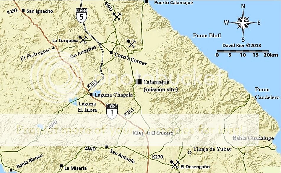
[Edited on 1-10-2018 by David K]
|
|
|
WideAngleWandering
Nomad
Posts: 390
Registered: 3-13-2012
Location: US-Based but traveling
Member Is Offline
|
|
Reasonable to traverse those either of those 4wd trails with a single vehicle? My 4wd is capable, I'm a decent driver, but I won't have a backup
vehicle on this leg.
Traveling the Americas via my old land cruiser
|
|
|
David K
Honored Nomad
Posts: 64479
Registered: 8-30-2002
Location: San Diego County
Member Is Offline
Mood: Have Baja Fever
|
|
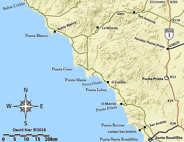
I did, last year... in a Tacoma. Having others along would be fun... but not mandatory with a good 4WD and experience. I drove the road from K270 to
the fork west of La Miseria, then south to the coast road, which I was on 2 days before.
[Edited on 1-10-2018 by David K]
|
|
|
AKgringo
Elite Nomad
Posts: 5805
Registered: 9-20-2014
Location: Anchorage, AK (no mas!)
Member Is Offline
Mood: Retireded
|
|
"Day 14" happens about what day on the calendar? Ski season has been a bust so far in the Donner Summit area, so I might as well be in Baja!
I have some significant mechanical problems to overcome before I head south, but would love to explore that area.
If you are not living on the edge, you are taking up too much space!
"Could do better if he tried!" Report card comments from most of my grade school teachers. Sadly, still true!
|
|
|
TMW
Select Nomad
Posts: 10659
Registered: 9-1-2003
Location: Bakersfield, CA
Member Is Offline
|
|
The road from either KM252 or KM270 would be the safest since there are ranches along the way. Some of the ranches are abandoned. This road is used by
the locals on a regular bases. The fish camp at Bahia Blanco is at the north end.
|
|
|
David K
Honored Nomad
Posts: 64479
Registered: 8-30-2002
Location: San Diego County
Member Is Offline
Mood: Have Baja Fever
|
|
| Quote: Originally posted by TMW | | The road from either KM252 or KM270 would be the safest since there are ranches along the way. Some of the ranches are abandoned. This road is used by
the locals on a regular bases. The fish camp at Bahia Blanco is at the north end. |
Tom, that l-o-n-g, deeply rutted grade down the mountain between San Antonio and La Miseria, was pretty bad last year. Other than San Antonio and La
Miseria (where I rescued the couple who were without food or transportation), I saw no other ranches other than a couple of very abandoned ones. The
lady at La Miseria said there has been nobody along the road in a couple of months (maybe that she saw or heard?).
|
|
|
TMW
Select Nomad
Posts: 10659
Registered: 9-1-2003
Location: Bakersfield, CA
Member Is Offline
|
|
At the Jct where the roads from KM252 and KM270 come together there is a white house that sets up on a hillside to the north. I have met the owner. I
really can't say he still lives there or not now as it's been a coup[le of years. The ranch you call La Miseria was called Las Palomas when I was
there and there are a couple of roads that bypassed the ranch, I just happened upon it because I kept going left at each jct to stay out of the silt
beds as I headed to the hwy. There is another ranch further west across the valley to the north from the jct called Cordornices. If I remember
correctly there are buildings there and cattle. It too may be abandoned with only the cattle roaming from the La Miseria ranch.
The road from Hwy 1 at KM 234 is very seldom used and is fenced along the hwy. As you come down the hill near the ocean there are many silt beds.
Before the fence at the hwy went up there were large trucks hauling beach rocks to sell. Maybe the fence was put up to stop them. Maybe the tire guy
at the Chapala Jct or the restaurant owner to the south would know.
|
|
|
David K
Honored Nomad
Posts: 64479
Registered: 8-30-2002
Location: San Diego County
Member Is Offline
Mood: Have Baja Fever
|
|
| Quote: Originally posted by TMW | At the Jct where the roads from KM252 and KM270 come together there is a white house that sets up on a hillside to the north. I have met the owner. I
really can't say he still lives there or not now as it's been a coup[le of years. The ranch you call La Miseria was called Las Palomas when I was
there and there are a couple of roads that bypassed the ranch, I just happened upon it because I kept going left at each jct to stay out of the silt
beds as I headed to the hwy. There is another ranch further west across the valley to the north from the jct called Cordornices. If I remember
correctly there are buildings there and cattle. It too may be abandoned with only the cattle roaming from the La Miseria ranch.
The road from Hwy 1 at KM 234 is very seldom used and is fenced along the hwy. As you come down the hill near the ocean there are many silt beds.
Before the fence at the hwy went up there were large trucks hauling beach rocks to sell. Maybe the fence was put up to stop them. Maybe the tire guy
at the Chapala Jct or the restaurant owner to the south would know.
|
I chatted with StuckSucks (Jim) about the Chapala (Km 234) to Coast road as he travels it for Cops Racing Team pit support. I was going to drive it on
my trip in the area but rescuing the couple at La Miseria foiled that plan. Jim told me it was passable in 2WD but borderline, and with silt, adding
the term "4WD" to it, on my map, seemed the wise thing to do.
La Miseria is pretty interesting as it has a hot tub and pool... You can see those on satellite images.
|
|
|
WideAngleWandering
Nomad
Posts: 390
Registered: 3-13-2012
Location: US-Based but traveling
Member Is Offline
|
|
Day 1 should have been today. Maybe it will be tomorrow. So much to do. Got to get packing.
Doing this in a new truck and I'm still working out the kinks.
Traveling the Americas via my old land cruiser
|
|
|


