| Pages:
1
2
3
4
5
6
..
9 |
David K
Honored Nomad

Posts: 64480
Registered: 8-30-2002
Location: San Diego County
Member Is Offline
Mood: Have Baja Fever
|
|
Quote: Originally posted by msulkers  | | Quote: Originally posted by David K | | Nope, I didn't travel Parque Constitucion 1857 until last August and these maps I produced after my 2017 trips. If and when I make another to include
the Laguna Hanson roads, I will add it to this page. I am just low on energy for such work at the moment... It takes a lot of work to make these maps!
|
We travelled this route, from La Rumarosa to Rancho la Ponderosa and then south to Laguna Hanson and then Ojos Negros from October 15-17th, 2019. Road
to Rancho la Ponderosa is good 2wd; the rancho is no longer open, but makes a good camp spot. The road from RLP south is generally good 2WD, but when
one comes to an obvious three way "Y", the centre route is signed as the route to Rancho El Topo and Parque Nacional Constitucion 1857.
This is not the most direct route, and involves a higher clearance, narrow alternative with some water damage that brings one out to Rancho El Topo.
At RET, we turned east to gain the original left fork and continued on good 2WD to Laguna Hanson. We did not encounter a single vehicle in over 70km
of backroad...
The park was deserted, but relatively well maintained. The parqueguardes didn't have annual passes available and no longer sell one night passes, so
we had to pay for three days (250$M) to stay for one night. There is water available at the parqueguarde camp, but it must be boiled...
Road out to Ojos Negros was solid, sporty washboard and took more than an hour in our loaded truck.
Can't wait for your guidebook, David K! |
Thanks... that belongs in a trip report here!
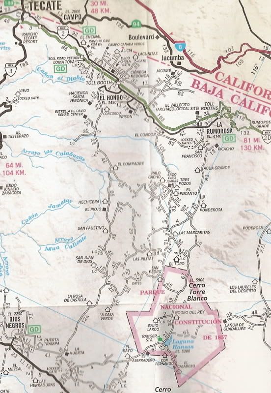
I traveled the main Laguna Hanson road from Hwy. 3 to Hwy. 2/ La Rumorosa in August 2018. This was after I made my 30 maps and I didn't know I was
going to be able to get Laguna Hanson into the road guide before that trip... so no map was created for the Sierra Juarez.
Here is my road log:
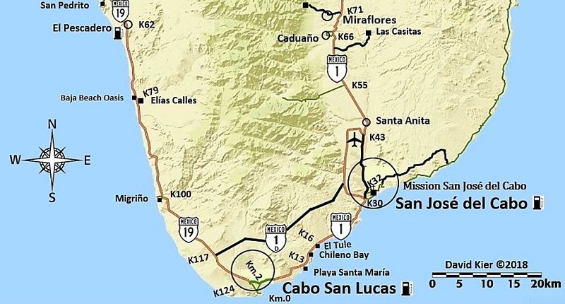
Mile 0.0 Highway 3 (Km. 54.5)
Mile 2.7 Fork left.
Mile 3.8 Fork right.
Mile 4.8 Oak trees.
Mile 5.2 Fork left. Elev. 4,000’.
Mile 11.2 Pine trees begin. Elev. 5,000’.
Mile 13.7 Rancho El Rayo.
Mile 15.1 Road southeast to Rancho La Botella. Cattle Guard crossing.
Mile 16.2 Aserradero an abandoned sawmill town with some tourist services. Food.
Mile 17.5 Cabins, market, food.
Mile 19.8 Laguna Hanson: park headquarters, cabins, daily use fee 64 pesos. Elev. 5,300’.
Road heads north passing by the lake which is shallow and often empty.
Mile 20.5 A Kilometer 60 sign facing north.
Mile 22.1 Road east to Rancho San Luis.
Mile 24.6 Rodeo del Rey, an abandoned hotel.
Mile 25.0 Road west to Rancho Bajío Largo.
Mile 35.6 Road west to Rancho El Topo.
Mile 40.4 Former mining area of La Milla.
Mile 41.4 Road northwest to El Condor. Elev. 4,900’
Mile 42.7 Road junction southwest from Las Margaritas.
Mile 45.6 Rancho Ponderosa road east. Tourist services offered.
Mile 48.7 Rancho Nuevo road east.
Mile 53.1 Inspection station.
Mile 55.1 Blacktop paved road.
Mile 55.4 Parques Los Potrillos and El Tesoro campgrounds.
Mile 57.5 Highway #2 (Km. 72), La Rumorosa. Mexicali is east and Tecate is west. The toll highway, Mexico 2-D can be accessed by turned west for a
short distance on Highway #2.
I have photos to go with the road log. You can see them in the Trip Reports section in TRIP #8.
Here are AAA and Baja Almanac maps covering that road:
New:

[Edited on 11-23-2020 by David K]
|
|
|
msulkers
Newbie
Posts: 9
Registered: 12-12-2016
Member Is Offline
|
|
Perfect! On the AAA map, just south of Rancho la Ponderosa, the three way "Y" is indicated. From Las Margaritas to Rancho El Topo, the middle road is
single width and has some water damage. There would be passing points in some of the arroyos.
Faster route would be the more easterly option, but the middle one was very scenic...
|
|
|
David K
Honored Nomad
Posts: 64480
Registered: 8-30-2002
Location: San Diego County
Member Is Offline
Mood: Have Baja Fever
|
|
| Quote: Originally posted by msulkers | Perfect! On the AAA map, just south of Rancho la Ponderosa, the three way "Y" is indicated. From Las Margaritas to Rancho El Topo, the middle road is
single width and has some water damage. There would be passing points in some of the arroyos.
Faster route would be the more easterly option, but the middle one was very scenic... |
For fun, let's compare my mileage figures with AAA (in bold), at the same points (or close)... Naturally, since AAA did their mapping
nearly 20 years ago, the road could have been realigned with new grading.
Mile 0.0 Highway 3 (Km. 54.5)
Mile 2.7 2.9 Fork left.
Mile 3.8 4.1 Fork right.
Mile 13.7 13.7 Rancho El Rayo.
Mile 19.8 20.4 Laguna Hanson: park headquarters, cabins, daily use fee 64 pesos. Elev. 5,300’.
Mile 22.1 22.5 Road east to Rancho San Luis.
Mile 25.0 25.4 Road west to Rancho Bajío Largo.
Mile 35.6 35.9 Road west to Rancho El Topo.
Mile 42.7 43.1 Road junction southwest from Las Margaritas.
Mile 45.6 45.9 Rancho Ponderosa road east. Tourist services offered.
Mile 57.5 57.9 Highway #2 (Km. 72), La Rumorosa. Mexicali is east and Tecate is west. The toll highway, Mexico 2-D can be accessed by
turned west for a short distance on Highway #2.
Not bad... mostly I was the same to .4 of AAA. Laguna Hanson point for me was the entrance gate and for AAA looks to be a road junction just past so
maybe why .6 difference there?
[Edited on 10-22-2019 by David K]
|
|
|
ehall
Super Nomad
Posts: 1906
Registered: 3-29-2014
Location: Buckeye, Az
Member Is Offline
Mood: It's 5 o'clock somewhere
|
|
Bump to the top for 2020. Thanks again DK , this makes for easy trip planning.
|
|
|
Barry A.
Select Nomad
Posts: 10007
Registered: 11-30-2003
Location: Redding, Northern CA
Member Is Offline
Mood: optimistic
|
|
This is really great, David. Probably because you have not explored the area yet, I did notice that a map of the east coast south of El Barril down
to Santa Rosalia appears to be missing. Some incredible country and coast along that stretch, and there are rudimentary "roads" accessing much of it.
That area has been hit with devastating flash-floods which have altered or destroyed many of the previous roads in this area.
|
|
|
Ken Cooke
Elite Nomad
Posts: 8921
Registered: 2-9-2004
Location: Riverside, CA
Member Is Offline
Mood: Black Trans Lives Matter
|
|
Will these maps be published? I saw me too of a Baja Bound Map? Is this the title of a book?
|
|
|
David K
Honored Nomad
Posts: 64480
Registered: 8-30-2002
Location: San Diego County
Member Is Offline
Mood: Have Baja Fever
|
|
| Quote: Originally posted by Barry A. | | This is really great, David. Probably because you have not explored the area yet, I did notice that a map of the east coast south of El Barril down
to Santa Rosalia appears to be missing. Some incredible country and coast along that stretch, and there are rudimentary "roads" accessing much of it.
That area has been hit with devastating flash-floods which have altered or destroyed many of the previous roads in this area.
|
Thanks for the nice words, Barry and Ed!
I made maps to show the area of Baja I was doing road logs of in 2017 for Baja Bound's future road guide. There are areas without roads or roads I
hadn't drove, so no map of those parts of Baja. South of El Barril being one of those areas. The other major area I did not make a map of, but had
started to, was the Sierra Juarez (Laguna Hanson region).
I was going to cover that area on my October 2017 trip (Trip #7) but I had a brake fail going to Mike's Sky Rancho from El Coyote, so I needed to turn
around. I was able to get back to cover Laguna Hanson roads in August of 2018 (Trip #8), but the map making did not get done with one more to cover
that area... It is VERY hard work and I didn't have any more energy.
The map making for the guide I did on my own, it was not requested and I was not being paid to make them.. I just thought the guide would work better
with the visual aid of maps. I first looked for maps already made I could use or edit but the ones from Google and other sources all had BAD
information on them I couldn't get rid of, such as wrong names for towns or highways. I had to make a map from scratch with just a satellite or
terrain base map.
I found one that only had the major federal highways and nothing much else. I then drew in all the dirt roads by switching to satellite view and
drawing a line over them then going back to the terrain map to save. I also had to add symbols for highways, airports, gas stations, mines, etc. John
M helped a lot with these symbols for me! Lots of work... but I am glad I did them!
Maybe before the first edition of the new guide is published, I will make the Sierra Juarez map?
*) Yes, the release date is by this summer, the maps will likely be in the book.
*) I don't understand: "me too of a Baja Bound Map"?
*) The book may be called the 'Baja Bound Road Guide' but that is not set in stone.
|
|
|
Ken Cooke
Elite Nomad
Posts: 8921
Registered: 2-9-2004
Location: Riverside, CA
Member Is Offline
Mood: Black Trans Lives Matter
|
|
Thanks for answering my questions. One of which I did not ask correctly due to auto correction having it's own input.
This will be helpful as Baja has gone through some changes since the days of the Baja Almanac. I also prefer a printed, non-virtual medium as a
counterpart to the ubiquitous Gaia that I hope to one day also run alongside my Android apps.
|
|
|
David K
Honored Nomad
Posts: 64480
Registered: 8-30-2002
Location: San Diego County
Member Is Offline
Mood: Have Baja Fever
|
|
When we can't drive Baja, then looking at maps of Baja can help with virtual travel!
|
|
|
MontyF
Junior Nomad
Posts: 25
Registered: 3-21-2004
Member Is Offline
|
|
thank you David for all the work and enthusiasm you have committed.
I know I will use these maps in the future and would definitely be interested in a published version.
|
|
|
David K
Honored Nomad
Posts: 64480
Registered: 8-30-2002
Location: San Diego County
Member Is Offline
Mood: Have Baja Fever
|
|
| Quote: Originally posted by MontyF | thank you David for all the work and enthusiasm you have committed.
I know I will use these maps in the future and would definitely be interested in a published version.
|
Very kind of you to say so! Welcome to Baja Nomad, too.
The publishing of them was to take place for release this summer...
Alas, no doubt that the Coronavirus will delay that...
[Edited on 4-16-2020 by David K]
|
|
|
4x4abc
Ultra Nomad
Posts: 4163
Registered: 4-24-2009
Location: La Paz, BCS
Member Is Offline
Mood: happy - always
|
|
do it every day
keep finding great stuff
found the Enterprise

Attachment: MESA ENTERPRISE.kmz (814B)
This file has been downloaded 260 times
Harald Pietschmann
|
|
|
David K
Honored Nomad
Posts: 64480
Registered: 8-30-2002
Location: San Diego County
Member Is Offline
Mood: Have Baja Fever
|
|
Just a heads-up.
Photobucket (where most of my maps and images are hosted for forum posting) is being difficult (again) and these maps and other images may vanish
temporarily...
I have been using lately, www.PostImages.org as a very easy way to share photos and maps, resized to 800 pixels, to fit on Nomad without stretching the page sideways. I
will put the maps back up using that service, if needed.
I was being prepared for a Photobucket meltdown but my images have been ok even when other Nomads have lost theirs or experienced blurred/ watermarked
additions.
Sadly, even PostImages.org added a pay level to maintain sharpest quality that used to be standard for free. Nothing stays the same, as they say!
|
|
|
David K
Honored Nomad
Posts: 64480
Registered: 8-30-2002
Location: San Diego County
Member Is Offline
Mood: Have Baja Fever
|
|
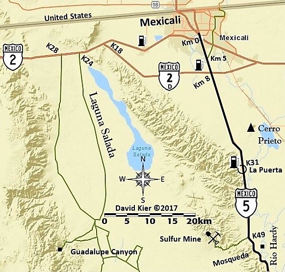
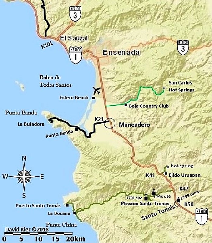
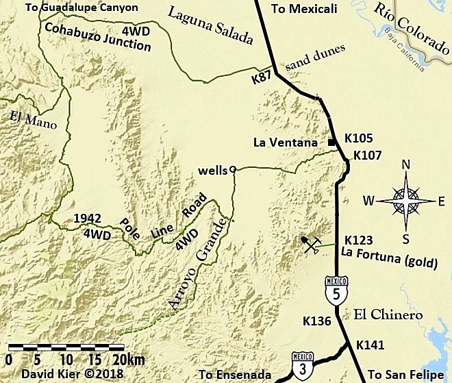
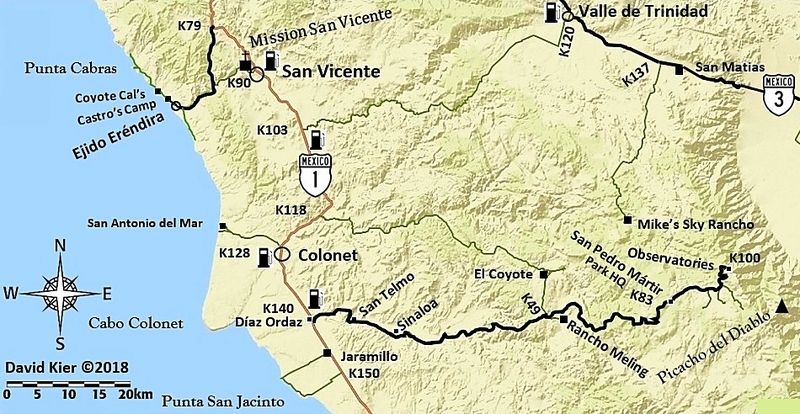
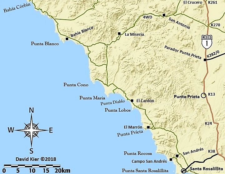
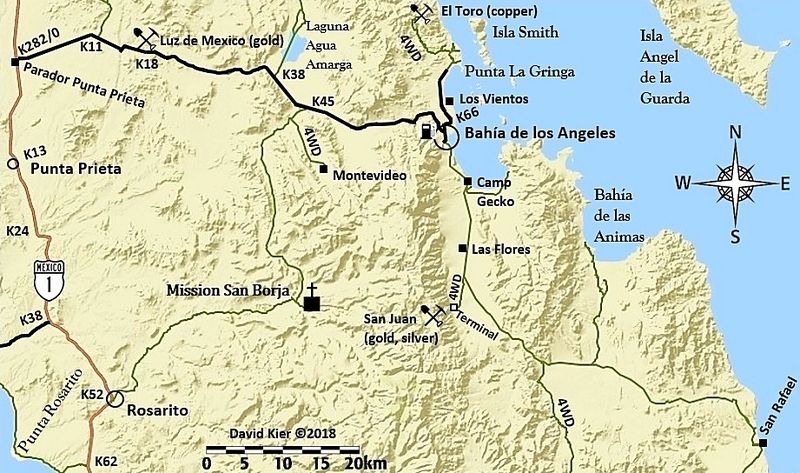
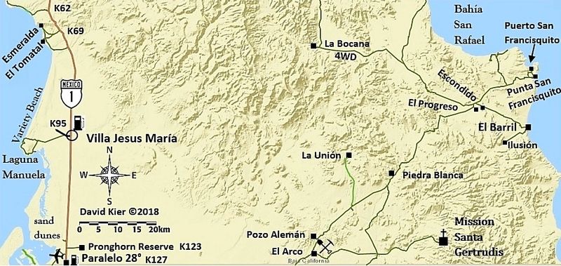
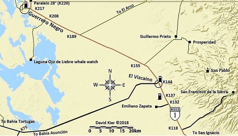
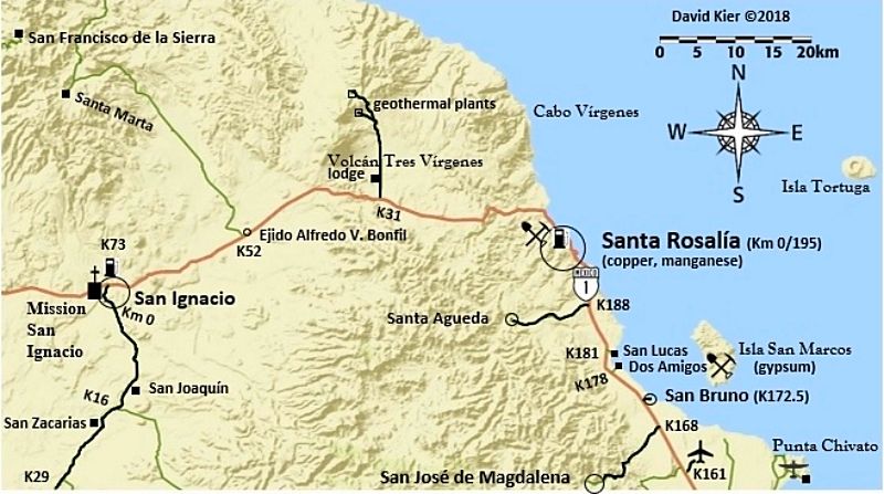
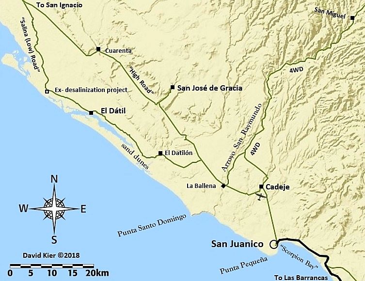
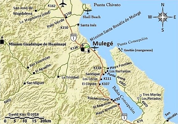
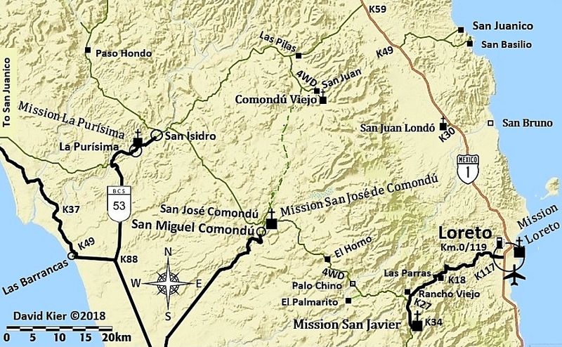
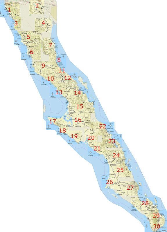
My 31 Baja Maps hosted on PostImages.org
Map 1
Map 2 (new)
Map 3
Map 4
Map 5
Map 6
Map 7
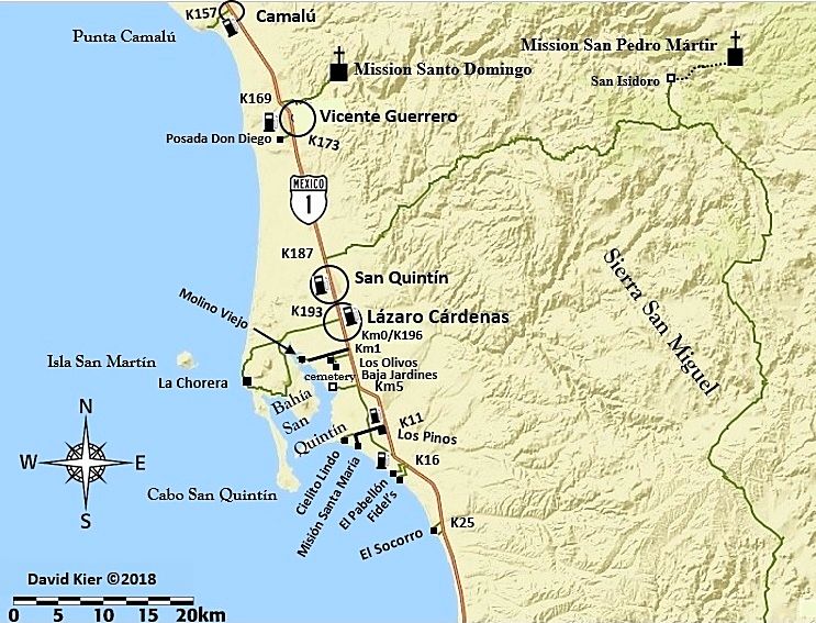
Map 8
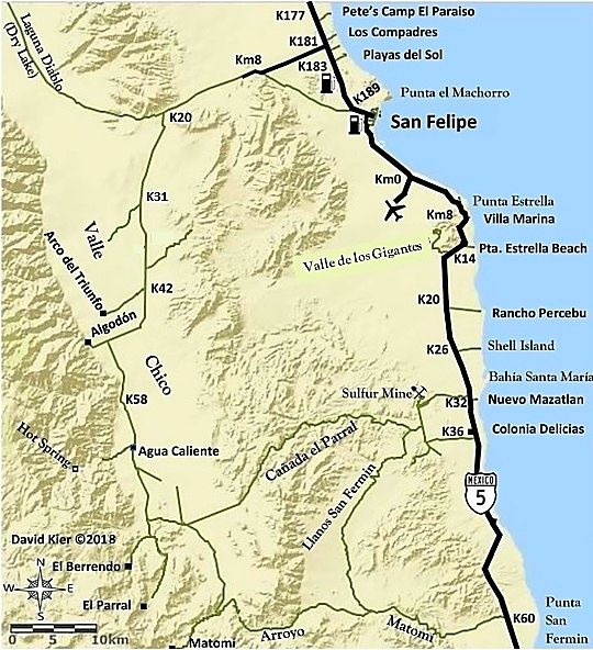
Map 9
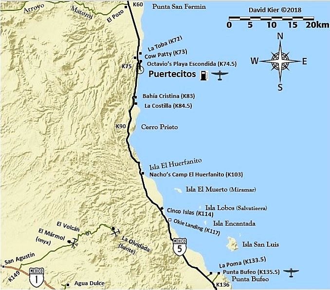
Map 10
Map 11
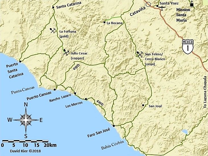
Map 12
Map 13
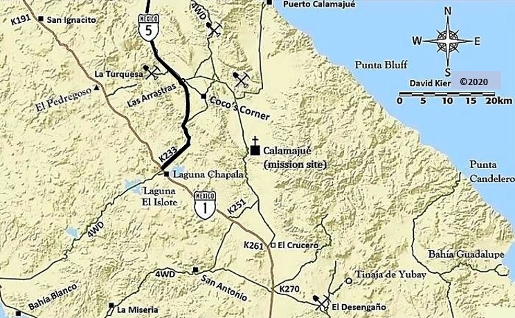
Map 13-A (kilometer markers added)
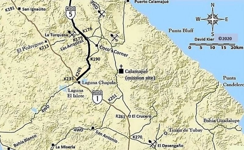
Map 14
Map 15
Map 16
Map 17
Map 18
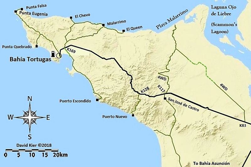
Map 19
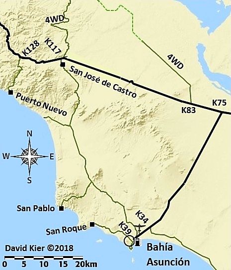
Map 20
Map 21
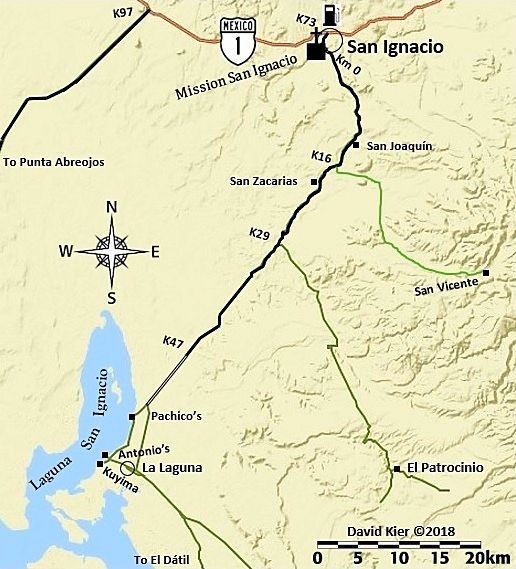
Map 22
Map 23
Map 24
Map 25
Map 26
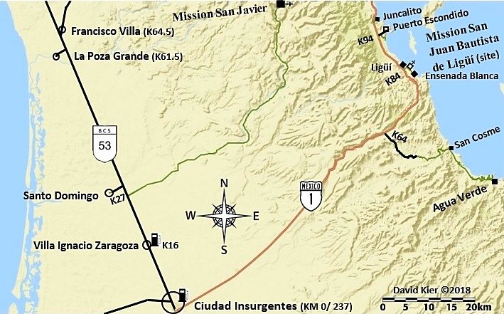
Map 27

Map 28
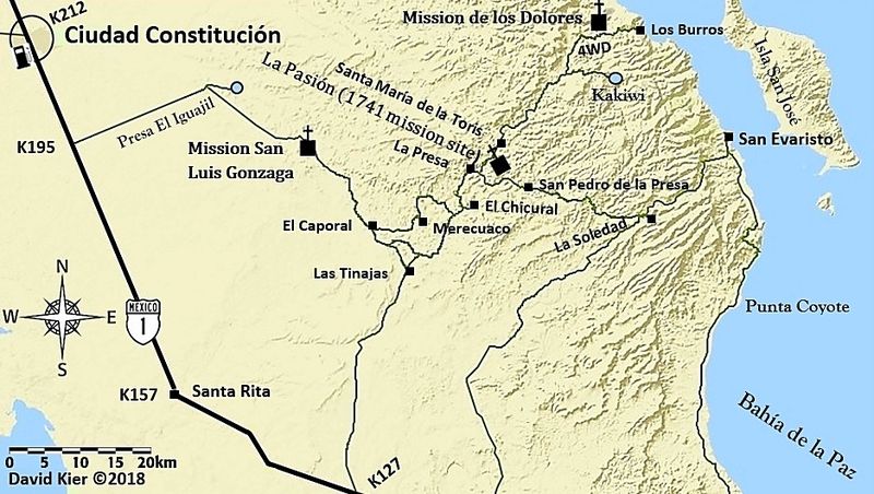
Map 29
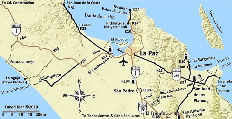
Map 30
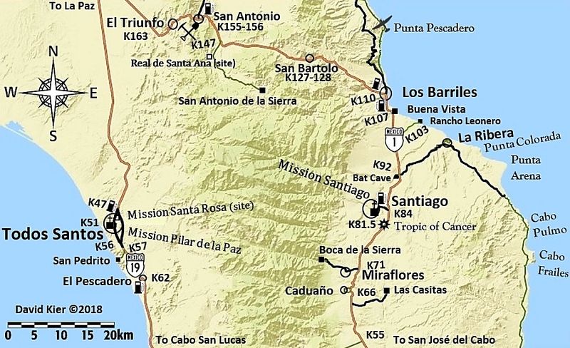
Map 31
[Edited on 12-1-2020 by David K]
[Edited on 1-28-2021 by David K]
|
|
|
David K
Honored Nomad
Posts: 64480
Registered: 8-30-2002
Location: San Diego County
Member Is Offline
Mood: Have Baja Fever
|
|
Baja Nomads are welcome to copy my 2018 maps for your private use. I welcome updates you find. I know that the road between Punta Abreojos and La
Bocana is now paved. I have edited Hwy. 5 to show the paving being completed earlier this year.
The possible Kilometer note additions on the newest Hwy. 5 paving:
K176 La Turquesa Mine Rd.
K180 Las Arrastras (bridge)
K190 just south of the south (old) road to Coco's
K201 End of Hwy. 5 at Hwy. 1
|
|
|
geoffff
Senior Nomad
Posts: 643
Registered: 1-15-2009
Member Is Offline
|
|
I love your maps, David! I decided I want to print them as a big wall map so I can highlight where I've been and see where I need to explore.
Here is a combo map I stitched together with all 30 of your maps, as well as an index with your map numbers. Click for big versions.
|
|
|
David K
Honored Nomad
Posts: 64480
Registered: 8-30-2002
Location: San Diego County
Member Is Offline
Mood: Have Baja Fever
|
|
WOW!!!  
Thanks, so cool!
|
|
|
Mr. Bills
Nomad
Posts: 189
Registered: 9-10-2019
Location: Area Code 530
Member Is Offline
|
|
So cool in fact that I'd love a copy of the files if available.
I tried "stitching" David's maps together and failed miserably.
|
|
|
David K
Honored Nomad
Posts: 64480
Registered: 8-30-2002
Location: San Diego County
Member Is Offline
Mood: Have Baja Fever
|
|
Indeed a lot of work from Geoff!
The problem with stitching the maps together is that each map was made to show a certain region, independently... While the scale is the same for
several, some were more detailed (larger scale) such as around Gonzaga Bay. To match up with the smaller scale maps, the larger ones needed to shrink
in size. That is why the text at Gonzaga Bay is so reduced compared to the other maps.
I was going to produce the map for the Sierra Juárez (Laguna Hanson roads)... but I just got exhausted and took a break. Now, unless I find the base
map I started, my map source (Arc GIS) no longer offers the same base map!
|
|
|
mtgoat666
Select Nomad
Posts: 17302
Registered: 9-16-2006
Location: San Diego
Member Is Offline
Mood: Hot n spicy
|
|
| Quote: Originally posted by David K | Indeed a lot of work from Geoff!
The problem with stitching the maps together is that each map was made to show a certain region, independently... While the scale is the same for
several, some were more detailed (larger scale) such as around Gonzaga Bay. To match up with the smaller scale maps, the larger ones needed to shrink
in size. That is why the text at Gonzaga Bay is so reduced compared to the other maps.
I was going to produce the map for the Sierra Juárez (Laguna Hanson roads)... but I just got exhausted and took a break. Now, unless I find the base
map I started, my map source (Arc GIS) no longer offers the same base map! |
Your maps are in arcgis, so just reformat, add new base layer, and print full penninsula map.
Woke!
“...ask not what your country can do for you – ask what you can do for your country.” “My fellow citizens of the world: ask not what America
will do for you, but what together we can do for the freedom of man.”
Prefered gender pronoun: the royal we
|
|
|
| Pages:
1
2
3
4
5
6
..
9 |


