| Pages:
1
..
3
4
5
6
7
..
9 |
David K
Honored Nomad

Posts: 64480
Registered: 8-30-2002
Location: San Diego County
Member Is Offline
Mood: Have Baja Fever
|
|
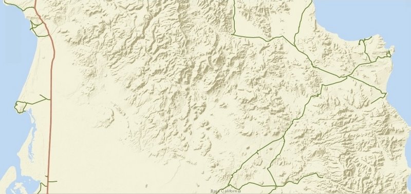
The base layer I originally used is no longer offered. The remaining base maps are all full of place names that don't compute and/or don't show
topography as well. I am very fussy when it comes to maps!
PS I am working on a new Baja map book for another publisher, so be happy that a replacement for the Baja Almanac or something similar is in the
works!
|
|
|
geoffff
Senior Nomad
Posts: 643
Registered: 1-15-2009
Member Is Offline
|
|
Quote: Originally posted by Mr. Bills  | So cool in fact that I'd love a copy of the files if available.
I tried "stitching" David's maps together and failed miserably. |
Hi Mr Bills, if you click on the image I posted, you'll get redirected to the large-size image. Here is the URL in any case: http://octopup.org/img/misc/forums/bajanomad/maps/o/Baja--Da...
If you are interested in my Photoshop file, I can send you that directly.
It wasn't too much work for me. I've gotten fast at this. It took me about 1-2 minutes per map - so about an hour total.
|
|
|
Mr. Bills
Nomad
Posts: 189
Registered: 9-10-2019
Location: Area Code 530
Member Is Offline
|
|
Thanks, the resolution is better now.
No need for the Photoshop file. I wouldn't know what to do with it.
Do you have a url for the image with the map numbers?
I think I might like to blow it up to 11 x14, laminate it, and tape it to the wall of my van so I can visualize my next adventure.
Assuming Covid-19 lets me have a next adventure.
|
|
|
geoffff
Senior Nomad
Posts: 643
Registered: 1-15-2009
Member Is Offline
|
|
This is the large image with page numbers: http://octopup.org/img/misc/forums/bajanomad/maps/o/Baja--Da...
And here is a version I tried with boxes around the maps too (Generated with OziExplorer), but the boxes didn't turn out perfect: http://octopup.org/img/misc/forums/bajanomad/maps/o/Baja--Da...
|
|
|
geoffff
Senior Nomad
Posts: 643
Registered: 1-15-2009
Member Is Offline
|
|
| Quote: Originally posted by David K | | The base layer I originally used is no longer offered. The remaining base maps are all full of place names that don't compute and/or don't show
topography as well. I am very fussy when it comes to maps! |
Yeah that sucks that they pulled the rug out from under you. ...
World Ocean Base doesn't have any words, and could probably be tweaked to look almost like your maps with some color adjustments in Photoshop: http://www.arcgis.com/home/webmap/viewer.html?url=http%3A%2F...
And there's their National Geographic layer - but some words would need removing: http://www.arcgis.com/home/webmap/viewer.html?url=http%3A%2F...
But long term, Open Street Maps with a hillshading overlay might be the way to go. You can get OSM maps rendered any way you like (no words).
[Edited on 11-12-2020 by geoffff]
|
|
|
Mr. Bills
Nomad
Posts: 189
Registered: 9-10-2019
Location: Area Code 530
Member Is Offline
|
|
Thanks for the links. The version with the boxes looks perfect to me.
|
|
|
David K
Honored Nomad
Posts: 64480
Registered: 8-30-2002
Location: San Diego County
Member Is Offline
Mood: Have Baja Fever
|
|
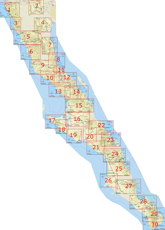
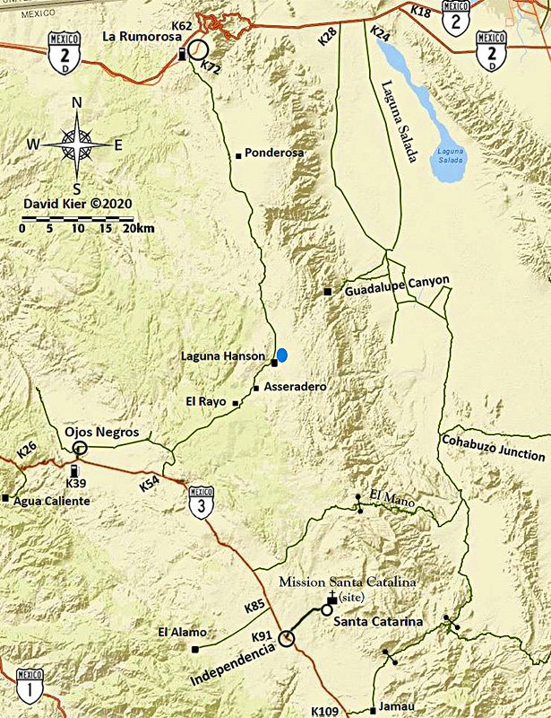
Geoff, any hope here...?
So, I found the two maps I had captured to make the Sierra Juárez/ Laguna Hanson regional map. This was the one map that is missing from my series to
cover the majority of roads.
Looks like I began working on them by adding the main dirt roads.
Two captures, labeled Sierra Juárez and Hwy. 3...
With just these saved images can I wonder if make the set complete? I used ArcGIS to draw in dirt roads by flipping to satellite image and back to the
base map. Maybe I have enough dirt roads?
I use Word to add place names and symbols.
==============================================================================
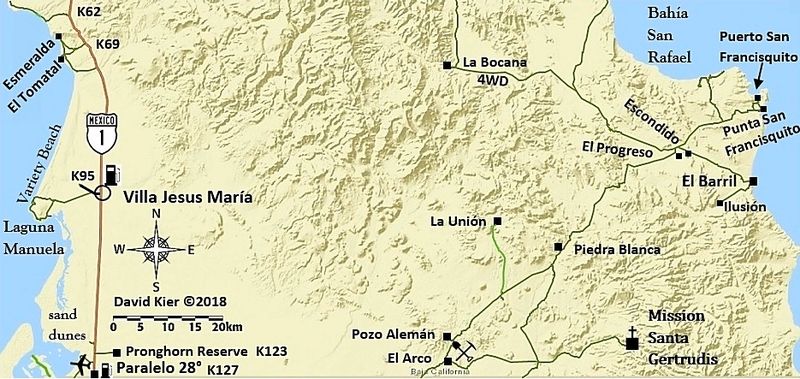
Here are some of the steps I made to create a map with editing out and adding to, using the El Arco map:
This is what I start with, only Hwy. 1 is shown, few or no names:
Using satellite image flipping to and drawing over, I add dirt roads I want to include.
Pasting onto a Word page, I add names and symbols...
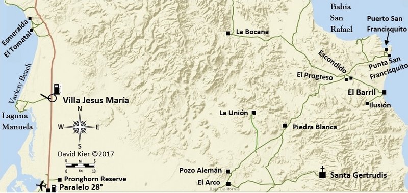
I then changed the kilometer scale and added Hwy. 1 logos, gas pumps, airplanes, mine symbols, mission symbols, etc. I also enhanced the image color
with a feature on Photobucket, (that is no longer the same)!
Tah dah...
|
|
|
geoffff
Senior Nomad
Posts: 643
Registered: 1-15-2009
Member Is Offline
|
|
For those who were wondering, David and I found a way to get back access to the base layer maps he was using.
|
|
|
David K
Honored Nomad
Posts: 64480
Registered: 8-30-2002
Location: San Diego County
Member Is Offline
Mood: Have Baja Fever
|
|
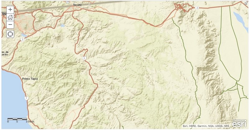
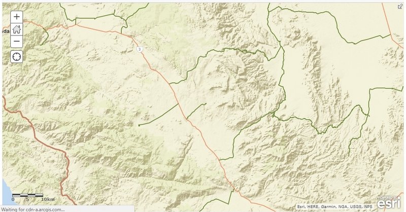
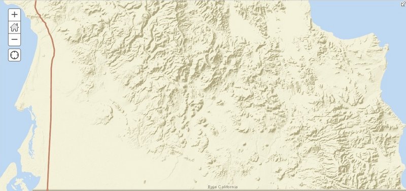
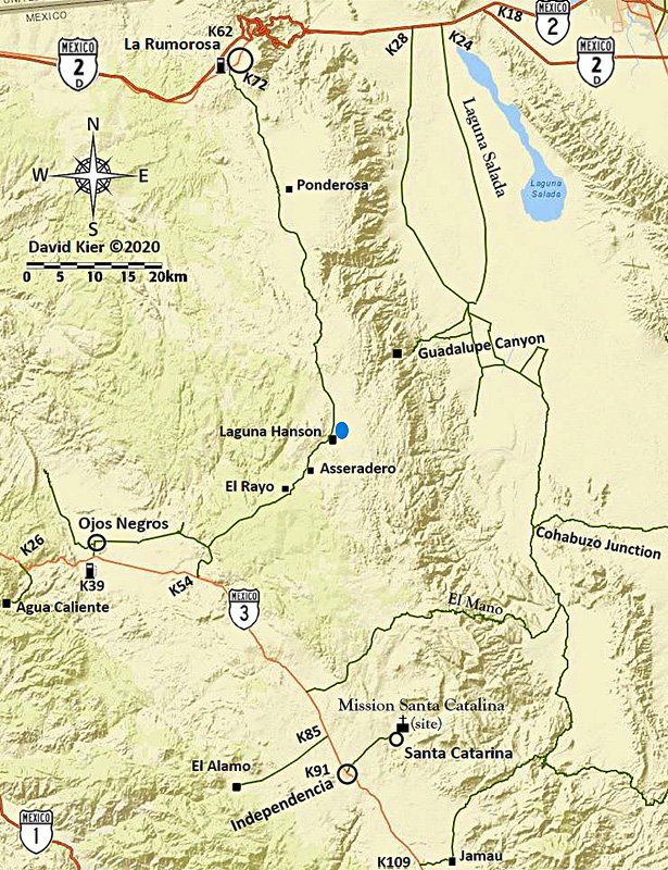
First draft 2020 Map #31 Sierra Juárez Region
Well, blowing the dust off my map work station and with support from geoffff for his knowledge of getting back a layer that had been removed from the
ArcGIS menu, I just been working the past 6 hours and think I may close...
Now, geoffff can enhance the image from this so it will resemble the other 30 maps.
Pre-enhancing version for your viewing entertainment!:
Enhanced by geoffff:
[Edited on 6-21-2021 by David K]
|
|
|
PaulW
Ultra Nomad
Posts: 3005
Registered: 5-21-2013
Member Is Offline
|
|
David, you need to mark a lock gate between Jamau and the junction of the old poll line track. The only access is for races, and then for that limited
time.
And for Mano there are two gates at a ranch, but most of the time they are unlocked. I suggest just showing "gate".
[Edited on 11-21-2020 by PaulW]
|
|
|
David K
Honored Nomad
Posts: 64480
Registered: 8-30-2002
Location: San Diego County
Member Is Offline
Mood: Have Baja Fever
|
|
| Quote: Originally posted by PaulW | David, you need to mark a lock gate between Jamau and the junction of the old poll line track. The only access is for races, and then for that limited
time.
And for Mano there are two gates at a ranch, but most of the time they are unlocked. I suggest just showing "gate".
[Edited on 11-21-2020 by PaulW] |
Thank you Paul...
The maps reflect roads I have traveled or that I mentioned in the guide to give guide users some orientation as to where these roads are in relation
to where they are.
The Pole line road gate was driven around on our 2015 trip after you or someone reported a go around, which is the line. I fear gates will continue to
be an issue preventing enjoyment of vast open lands and corralling people into tourist area, which is not healthy with Covid!
Since I elected to not include road logs for the dirt roads with gates you mentioned, I am not sure if adding them is needed?
Do you have the GPS for gates you think should be included? Maybe geoffff can help me add them?
Here is the enhanced map from geoffff... I may try and improve the line for Hwy. 3 :
|
|
|
PaulW
Ultra Nomad
Posts: 3005
Registered: 5-21-2013
Member Is Offline
|
|
Gates:
Mano: Two corral gates at Ranch. Locked years back. Now open.
31 49.249, -115 45.293 per GPS
Pole L R Locked gate:
31 37.7877, -115 35.154 per GPS
Pole L R Lock gate bypass: Cable, not passable
31 37.75, -115 35.19 Nearby on that track
Pole L R Fence gate:
31 38.099, -115 34.94 per GPS
Race Summit road gate: Forgot to make WP and I will not drive there because I cannot turn around due to big drop off.
31 35, -115 42 is close
|
|
|
David K
Honored Nomad
Posts: 64480
Registered: 8-30-2002
Location: San Diego County
Member Is Offline
Mood: Have Baja Fever
|
|
Thanks Paul... Geoffff is working on it now... I am not home currently.
|
|
|
mtgoat666
Select Nomad
Posts: 17302
Registered: 9-16-2006
Location: San Diego
Member Is Offline
Mood: Hot n spicy
|
|
| Quote: Originally posted by PaulW | David, you need to mark a lock gate between Jamau and the junction of the old poll line track. The only access is for races, and then for that limited
time.
And for Mano there are two gates at a ranch, but most of the time they are unlocked. I suggest just showing "gate".
[Edited on 11-21-2020 by PaulW] |
re gated private roads, suggest deleting the roads, as they are not public routes.
mapping convention for these types of maps is to show only public routes.
Woke!
“...ask not what your country can do for you – ask what you can do for your country.” “My fellow citizens of the world: ask not what America
will do for you, but what together we can do for the freedom of man.”
Prefered gender pronoun: the royal we
|
|
|
David K
Honored Nomad
Posts: 64480
Registered: 8-30-2002
Location: San Diego County
Member Is Offline
Mood: Have Baja Fever
|
|
Most gates are to control cattle movement not people movement.
|
|
|
David K
Honored Nomad
Posts: 64480
Registered: 8-30-2002
Location: San Diego County
Member Is Offline
Mood: Have Baja Fever
|
|
Gate symbols added plus Highway 3 darkened, etc.
Thanks Geoffff.
NOMADS: Feedback on the gates (Paul?)... please.
Paul, should the gate shown at the bottom of the Summit grade be on the road heading to Pole Line Road area rather than be on the road heading to
Cohabuzo Jcn.?
In 2015, there was a cattle gate we went through nearing the bottom of the summit as we were driving south from Cohabuzo Jcn. then the impassable iron
gate on the Pole Line Road at Arroyo Saiz requiring that detour.
Thanks!
|
|
|
PaulW
Ultra Nomad
Posts: 3005
Registered: 5-21-2013
Member Is Offline
|
|
| Quote: Originally posted by David K |
Gate symbols added plus Highway 3 darkened, etc.
Thanks Geoffff.
NOMADS: Feedback on the gates (Paul?)... please.
Paul, should the gate shown at the bottom of the Summit grade be on the road heading to Pole Line Road area rather than be on the road heading to
Cohabuzo Jcn.?
In 2015, there was a cattle gate we went through nearing the bottom of the summit as we were driving south from Cohabuzo Jcn. then the impassable iron
gate on the Pole Line Road at Arroyo Saiz requiring that detour.
Thanks! |
=== =
* Suggest moving the Iron PLR gate as shown in red
* Forget about the cable due to lack of detail in that area
* The cattle fence gate closer to Mano Jct is part of a fence line shown in red. In fact one has to pass thru two more fence gates along the ranchers
fence line when driving from Mano Jct up the toward the summit. The coords for the fence gate is where we pass thru to head N/S to access Enmedio or
Saiz the then to PLR.
* Is it possible to make the Mnao gate dashed or shaded to indicate it may be open as opposed to locked? Same comment about the fence gate just S of
Mano Jct.
Regarding the Mano trail the common track passes thru Indepencia and past the mission to the track you show. I have not driven Mano from Hwy3 as you
depict

|
|
|
David K
Honored Nomad
Posts: 64480
Registered: 8-30-2002
Location: San Diego County
Member Is Offline
Mood: Have Baja Fever
|
|
Hi Paul,
Thank you for your comments!
Yes, you show where the iron gate at the beginning of the original Pole Line Road run should be shown. I emailed geoffff to look and move the gate
symbol.
I don't think the Mano area cable gates need to be added and as I said before, this map is really for orientation while using the Baja Bound Road
Guide. I mention the Pole Line Road and the Guadalupe Canyon road but not the Mano Canyon road or the route I drove from Hwy. 3 to Mano that you
correctly say isn't the common road used.
I wanted folks to see there were routes over the mountain (that I personally drove) and to have a little more on the map.
The route I show from Hwy. 3 to Mano is one I drove in June 2003 after watching the Baja 500 near Hwy. 3 (Rancho Agua Blanca area). My son and I were
going on to meet with Ken Cooke and his Jeep posse in Guadalupe Canyon Hot Springs and I took the shortest route (some of it was the Baja 500 course
that year).
It was an easy drive for us in my 2001 Tacoma, and no gates anywhere to open on the road, but midway down Mano, where AAA maps showed a locked gate,
there was the posts and concrete but no closed or locked gate.
|
|
|
David K
Honored Nomad
Posts: 64480
Registered: 8-30-2002
Location: San Diego County
Member Is Offline
Mood: Have Baja Fever
|
|
Sierra Juárez Map (final edit)
With many thanks to geoffff... now featuring gates, the common way to Mano from Santa Catalina mission, and the "Compadre Trail"...
I will also renumber the maps so they make a logical key map. The newest map will be map 2, between 1 (Tijuana-Tecate) and 3 (Mexicali), rather than
Map 31.
[Edited on 11-23-2020 by David K]
|
|
|
PaulW
Ultra Nomad
Posts: 3005
Registered: 5-21-2013
Member Is Offline
|
|
Good job. I like the map now.
Having made further review of the Mano track I just realized I forgot about the Los Pinos gate. I do not think it was ever locked or closed.
For completeness here are the details
Los Pinos Ranch: 31 48.776, -115 46.326
Los Pinos Gate: 31 48.768, -115 46.448
Both from My GPS track
All the other ranches along/near the Mano track are on side roads and were not located on my tracks.
|
|
|
| Pages:
1
..
3
4
5
6
7
..
9 |


