| Pages:
1
2 |
David K
Honored Nomad

Posts: 64480
Registered: 8-30-2002
Location: San Diego County
Member Is Offline
Mood: Have Baja Fever
|
|
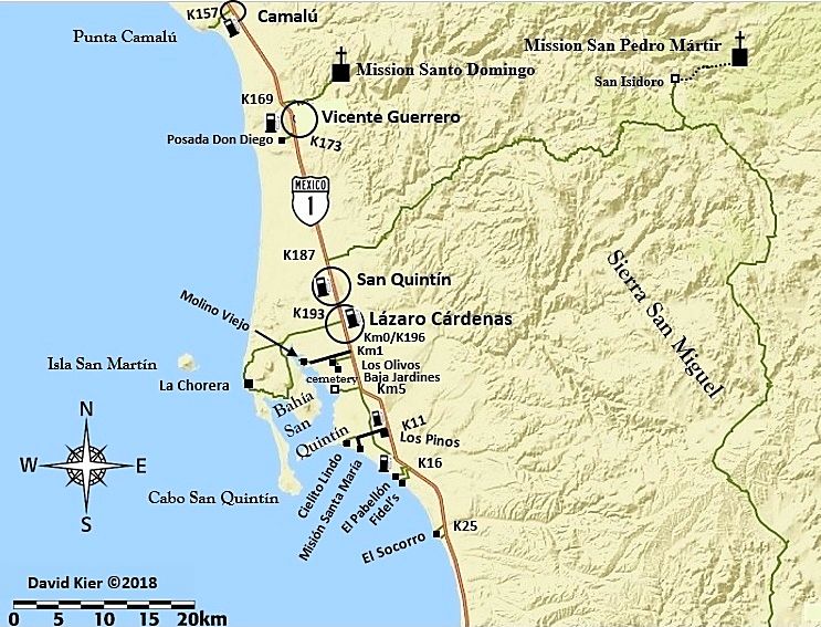
Newest 2018 Map: San Quintín Area
Please have a look and tell me if it flies for you.
I included the Sierra San Miguel mountain road, San Isidoro, etc. as TW and Squarecircle and other have been on it, and I would like to one day. I
limited some of the data, like gas stations (there are plenty in this section). I almost left out the Km markers as I thought it may get too busy.
[Edited on 5-1-2018 by David K]
|
|
|
bajaguy
Elite Nomad
Posts: 9247
Registered: 9-16-2003
Location: Carson City, NV/Ensenada - Baja Country Club
Member Is Offline
Mood: must be 5 O'clock somewhere in Baja
|
|
Put Parcela 12 on the map....it's a must see/eat location!!
|
|
|
David K
Honored Nomad
Posts: 64480
Registered: 8-30-2002
Location: San Diego County
Member Is Offline
Mood: Have Baja Fever
|
|
It is in the guide! 
Km. 16 El Pabellon (1.2 miles) Campground/RV Park (150 pesos). A popular restaurant, Parcela 12, is just ahead on the east side of
the highway.
|
|
|
4x4abc
Ultra Nomad
Posts: 4163
Registered: 4-24-2009
Location: La Paz, BCS
Member Is Offline
Mood: happy - always
|
|
no gas stations?
Harald Pietschmann
|
|
|
weebray
Super Nomad
Posts: 1094
Registered: 7-19-2010
Location: La Paz
Member Is Offline
Mood: lleno
|
|
Not to worry, plenty in the area and putting them in would only confuse the issue. I prefer the clean look. Personal favorites can be noted on your
own copy.
Every beautiful beach in the world needs a few condo towers - NOT.
|
|
|
David K
Honored Nomad
Posts: 64480
Registered: 8-30-2002
Location: San Diego County
Member Is Offline
Mood: Have Baja Fever
|
|
Gas stations added!
[Edited on 7-9-2018 by David K]
|
|
|
bajabuddha
Banned
Posts: 4024
Registered: 4-12-2013
Location: Baja New Mexico
Member Is Offline
Mood: Always cranky unless medicated
|
|
How about adding an 'inset' map of the greater San Quintin area only and have gas, hotels, etc. marked w/ turn-off km's? Kinda like City inset maps
in road atlases? Por que no?
I don't have a BUCKET LIST, but I do have a F***- IT LIST a mile long!
86 - 45*
|
|
|
David K
Honored Nomad
Posts: 64480
Registered: 8-30-2002
Location: San Diego County
Member Is Offline
Mood: Have Baja Fever
|
|
Quote: Originally posted by bajabuddha  | | How about adding an 'inset' map of the greater San Quintin area only and have gas, hotels, etc. marked w/ turn-off km's? Kinda like City inset maps
in road atlases? Por que no? |
That would be great for a stand-alone map, yes.
These maps are mated to the Guide so that readers of the Guide can have a quick and easy visual depiction of where they are compared to other places
noted in the Guide. I am showing these maps to all of you not for your enjoyment only, as they do go with the road logs I have made. But, to help me
make sure they are easy to see/understand, don't have incorrect data, and to make them the best possible. I already have a few things I see since
posting I will change.
There is/ will be, a Baja Bound on-line map in addition to these maps for the Guide. I have waypointed hotels and gas stations, campgrounds, points of
interest to be added to that map. I personally did not spend a lot of time looking for all motels, just ones that I spotted that I thought may be
useful to know about. I had a lot of ground to cover every day!
|
|
|
TMW
Select Nomad
Posts: 10659
Registered: 9-1-2003
Location: Bakersfield, CA
Member Is Offline
|
|
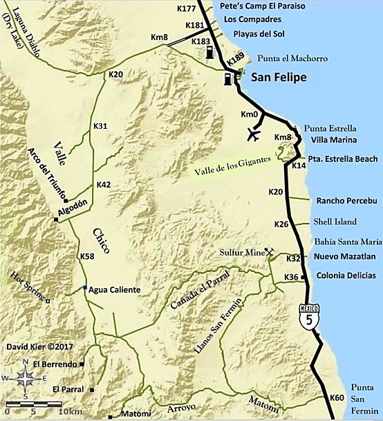
David you should add the road from K25 east to the road going down to K103.
|
|
|
David K
Honored Nomad
Posts: 64480
Registered: 8-30-2002
Location: San Diego County
Member Is Offline
Mood: Have Baja Fever
|
|
Hi Tom,
I did that road in 2005, found Petroglyph Park up there too. It was pretty bad then!
ADDED!
[Edited on 7-9-2018 by David K]
|
|
|
baronvonbob
Nomad
Posts: 196
Registered: 1-5-2010
Member Is Offline
|
|
No Pedregal?
|
|
|
David K
Honored Nomad
Posts: 64480
Registered: 8-30-2002
Location: San Diego County
Member Is Offline
Mood: Have Baja Fever
|
|
I saw no signs directing to Pedregal. Unless it is a camping area or has a motel or some other attraction to vacation travelers it is not shown.
Similar to why I don't include the dozens of 'campos' north and south of San Felipe that are private homes and not campgrounds.
Thank you for asking. If I did miss a place that should be included, do let me know so it could be added in a future update.
|
|
|
David K
Honored Nomad
Posts: 64480
Registered: 8-30-2002
Location: San Diego County
Member Is Offline
Mood: Have Baja Fever
|
|
San Quintín Map
OK, so I have moved a couple of the text lines, changed a size on some, added Sierra San Miguel to the map, and think it is easier to read now:
What say you?
The next map I have started today is the Puertecitos area (Arroyo Matomi to Punta Bufeo).
[Edited on 5-1-2018 by David K]
|
|
|
David K
Honored Nomad
Posts: 64480
Registered: 8-30-2002
Location: San Diego County
Member Is Offline
Mood: Have Baja Fever
|
|
Goes to show you that you can't have too many eyes looking at your work if you value accuracy!
In a final edit (well maybe final) edit of my manuscript, it was discovered I spelled a place with "las" when it should be a "los" (with Gigantes).
When I checked my notes, sure enough, I had it correct as los, but when typing, I used "las". That typo error transferred onto my San Felipe map (one
of the first I made)... So here is version 5 of the San Felipe Area map with Valle de los Gigantes!
Revised editionof this map...

[Edited on 7-12-2018 by David K]
|
|
|
4x4abc
Ultra Nomad
Posts: 4163
Registered: 4-24-2009
Location: La Paz, BCS
Member Is Offline
Mood: happy - always
|
|
about the Visita San Isidoro - the topo maps list it as San Isidro.
Which one is correct?
Google does not seem to know it at all
Harald Pietschmann
|
|
|
David K
Honored Nomad
Posts: 64480
Registered: 8-30-2002
Location: San Diego County
Member Is Offline
Mood: Have Baja Fever
|
|
Isidoro
You have my book, Harald: Page 160, and a photo of it from TW (TMW) is on page 216.
Edit:
I Googled "Visita San Isidoro", and got Nomad geoffff's post with the Almanac (which comes from Mexican topos) map showing 'Isidoro': http://octopup.org/baja2016/san-isidoro
[Edited on 7-9-2018 by David K]
|
|
|
David K
Honored Nomad
Posts: 64480
Registered: 8-30-2002
Location: San Diego County
Member Is Offline
Mood: Have Baja Fever
|
|
More:
It was named by Padre Juan Crespí [on the expedition from Loreto to San Diego], on April 4, 1769, which was the day of that saint. Crespí considered
it "an excellent spot for founding a good-sized mission."
Crespí spells it 'Ysidoro' but he also spells 'San Ygnacio' mission.
San Isidoro was the first place of several named by Crespí to survive to modern times.
The Saint: https://www.franciscanmedia.org/saint-isidore-of-seville/
[Edited on 7-9-2018 by David K]
|
|
|
4x4abc
Ultra Nomad
Posts: 4163
Registered: 4-24-2009
Location: La Paz, BCS
Member Is Offline
Mood: happy - always
|
|
Gracias, David!
Harald Pietschmann
|
|
|
David K
Honored Nomad
Posts: 64480
Registered: 8-30-2002
Location: San Diego County
Member Is Offline
Mood: Have Baja Fever
|
|
My pleasure! 
|
|
|
PaulW
Ultra Nomad
Posts: 3005
Registered: 5-21-2013
Member Is Offline
|
|
The road at K181 is paved to KM10. Past the dump road and around the curve
|
|
|
| Pages:
1
2 |


