| Pages:
1
2
3 |
chivatojoe
Junior Nomad

Posts: 99
Registered: 9-6-2007
Location: French Valley /Chivato/Asuncion
Member Is Offline
|
|
Mex 5 start of paving
Just drove down and back last week. They now have the first couple of miles of new road blocked off from the laguna chaparral Mex 1 side of the
construction. They are surveying ( laser road grader ) and blue topping the road base and a brand new asphalt batch plant complete with tanker of tar
is in place about 6 miles in. Looks like they will start paving from the Mex 1 side of things as the final and rough grading continues to the North.
New rock crushing plant set up to make final road base and most of the previous equipment site set ups are being moved and the last big mountain demo
is about to be completed. Actually have circumnavigated Coco's three times now and shaves off 2.3 to 2.5 miles of the 23.. and with other short cuts
drops the pavement to pavement run down to 18.1 miles. Will be a giant time saver. Mex 1 new pavement 10 miles North of BOLA turnoff helps with the
most severe pot holes but still need to be vigilant from Jesus Maria to Guerrero Negro as there are still tire eating holes that are sometimes
unavoidable. I'm thinking Coco should start a date of completion lottery just for fun and maybe raise a little beer money.
Soon those that have will be able to say " I remember when " as they cruise down the shinny new thoroughfare.
|
|
|
David K
Honored Nomad
Posts: 64480
Registered: 8-30-2002
Location: San Diego County
Member Is Offline
Mood: Have Baja Fever
|
|
Thank you for the report.
I was last on the Laguna Chapala to Gonzaga road in August and the new road was open and there was a bit a pavement over a bridge before reaching the
hills.
So, just to be clear... are you saying the Coco's Corner Bypass is open to traffic?
|
|
|
BooJumMan
Senior Nomad
Posts: 875
Registered: 8-11-2007
Location: San Diego
Member Is Offline
|
|
How exciting! Can't wait til they pave all of Baja so everything is much more accessible and easier to develop! 
In that pre-Google Earth and social media epoch, The Code was adhered to. It was based on a simple verity: if a locale had been transformational for
you, and you had put the hard yards in to get there and to learn it, to know it, why in god�s name would you broadcast the news, thus ruining the
future experience not only for yourself, but for future adventurers?
|
|
|
rts551
Elite Nomad
Posts: 6699
Registered: 9-5-2003
Member Is Offline
|
|
Quote: Originally posted by David K  | Thank you for the report.
I was last on the Laguna Chapala to Gonzaga road in August and the new road was open and there was a bit a pavement over a bridge before reaching the
hills.
So, just to be clear... are you saying the Coco's Corner Bypass is open to traffic? |
2 weeks ago it was only open if you jump the berm. It is ready for final and paving. I saw a "crew" chase down someone, read them the riot act, and
make them turn around. People were also trying to jump up on the lakebed road even though it was obviously closed with a finish grade on it.
glad to see tey have not taken the resources away from 5 to fix hwy 1.
|
|
|
bajagrouper
Senior Nomad
Posts: 964
Registered: 8-28-2003
Location: Rincon de Guayabitos, Nayarit, Mexico
Member Is Offline
Mood: happy and retired
|
|
I am coming across on the ferry from Mazatlan in mid February, I plan to drive up highway 5 to Mexicali, is there an exit off highway 1 so I can drive
this route? Thanks in advance...
I hear the whales song
|
|
|
mtnpop
Senior Nomad
Posts: 597
Registered: 9-8-2009
Location: Colorado/mulege
Member Is Offline
|
|
Can't miss it turn east at the tire store at Chapala, somewhere we have the km # filed....
we have friends coming thru in a few days so will get a new report again from them
This is good news for those of us that need to go east after exiting BAJA
Cuts off many hours and miles for us....
Common sense is a flower that doesn\'t grow in everyone\'s garden.....
A wise man once spoke nothing.....
Never kick a cow chip on a hot day!!
|
|
|
David K
Honored Nomad
Posts: 64480
Registered: 8-30-2002
Location: San Diego County
Member Is Offline
Mood: Have Baja Fever
|
|
| Quote: Originally posted by mtnpop | Can't miss it turn east at the tire store at Chapala, somewhere we have the km # filed....
we have friends coming thru in a few days so will get a new report again from them
This is good news for those of us that need to go east after exiting BAJA
Cuts off many hours and miles for us.... |
Km. 233+
See the Baja Nomad Kilometer Marker thread in this forum (Baja Road Conditions).
|
|
|
motoged
Elite Nomad
Posts: 6481
Registered: 7-31-2006
Location: Kamloops, BC
Member Is Offline
Mood: Gettin' Better
|
|
What.....no map? David....you are slipping.... 
Don't believe everything you think....
|
|
|
David K
Honored Nomad
Posts: 64480
Registered: 8-30-2002
Location: San Diego County
Member Is Offline
Mood: Have Baja Fever
|
|
Really?
A request for the Laguna Chapala Area Map?
Is this a trick???
|
|
|
motoged
Elite Nomad
Posts: 6481
Registered: 7-31-2006
Location: Kamloops, BC
Member Is Offline
Mood: Gettin' Better
|
|
David,
Bajagrouper asked above if there was an exit from Hwy 1 to 5....and as this topic has been beaten to death ....almost.... I thought that any response
would be a map rather than a reference to a mile marker (which may or may not exist/remain since last observation)....and you are usually helpful in
that regard....trying to inject some levity.....
I'm just a Bad Hombre in that regard....

Don't believe everything you think....
|
|
|
David K
Honored Nomad
Posts: 64480
Registered: 8-30-2002
Location: San Diego County
Member Is Offline
Mood: Have Baja Fever
|
|
|
|
|
David K
Honored Nomad
Posts: 64480
Registered: 8-30-2002
Location: San Diego County
Member Is Offline
Mood: Have Baja Fever
|
|
| Quote: Originally posted by bajagrouper | | I am coming across on the ferry from Mazatlan in mid February, I plan to drive up highway 5 to Mexicali, is there an exit off highway 1 so I can drive
this route? Thanks in advance... |
There is no 'exit' in the same sense as for a freeway. Highway 1 is simply a two-lane paved road in central Baja California. Highway 5 terminates at
Highway 1 (near Km. 233), at Laguna Chapala and runs all the way north to Mexicali. It is a wide roadbed going off to the right, as you are driving
north on Hwy. 1. There will be signs, they change... but this is just after passing the dry lake bed (on the right), Nuevo Chapala restaurant (on the
left) and is across from a tire shop (also on the left).
|
|
|
bajagrouper
Senior Nomad
Posts: 964
Registered: 8-28-2003
Location: Rincon de Guayabitos, Nayarit, Mexico
Member Is Offline
Mood: happy and retired
|
|
Thanks, I meant if there was a road ( dirt or paved ) it would be an exit.I have driven that route before but both times north to south but that was
1971 and 72, then you had to drive through a dry river bed and the "exit" on to highway 1 was a little further south. Since it is my 70th. Anniversary
of my first visit to Baja I thought I would like to see the changes to Highway 5...
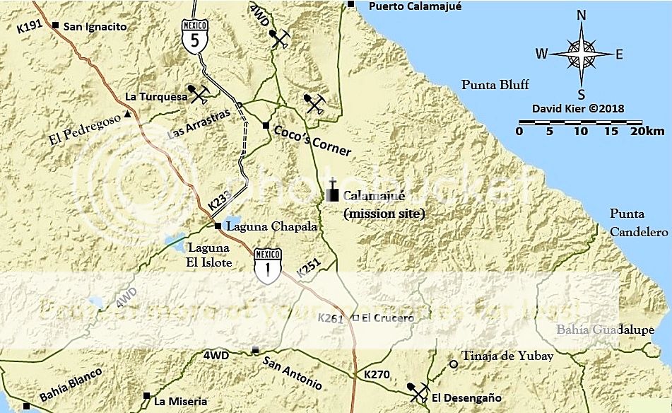
Thanks for the map, is the dotted section the part that is not complete yet, meaning do I go by coco's?
I hear the whales song
|
|
|
Sr.vienes
Nomad
Posts: 151
Registered: 7-23-2017
Member Is Offline
|
|
Holy cow grouper, I guess you really are a senior Nomad. 70th anniversary trip, it will be 2044 for mine. I guess i better start taking better care of
myself.
|
|
|
SuperScrappy
Newbie
Posts: 10
Registered: 2-7-2016
Member Is Offline
|
|
On our trip down we were able to drive the new road near Chapala but on our return trip they place big piles of material blocking that section of the
road. We came home over the weekend. We were able to cut across part of the mountain pass at kilometer 185 from the the Mex 1 end headed north (if
coming south it’s that Y- bend before headed towards Cocos). It cut out about 15-20 minutes of the dirt road drive. The only bad part is missing
Cocos. The first part that is most southerly is a single lane construction road not rough but take some dips slow. The other part of the pass is what
will be the new road, grated with some material one it and graded. Not sure how long it will be allowed as they are actively working on the road.
|
|
|
David K
Honored Nomad
Posts: 64480
Registered: 8-30-2002
Location: San Diego County
Member Is Offline
Mood: Have Baja Fever
|
|
| Quote: Originally posted by bajagrouper | Thanks, I meant if there was a road ( dirt or paved ) it would be an exit.I have driven that route before but both times north to south but that was
1971 and 72, then you had to drive through a dry river bed and the "exit" on to highway 1 was a little further south. Since it is my 70th. Anniversary
of my first visit to Baja I thought I would like to see the changes to Highway 5...
Thanks for the map, is the dotted section the part that is not complete yet, meaning do I go by coco's? |
That is super to hear, 70 years!
Yes, in 1972... even to 1983, the main route of "Hwy. 5" (or simply the Gulf Road) went through Calamajue Canyon to El Crucero and met the main
"transpeninsular" dirt road there (now Km. 261).
After 1973, there was a shortcut built so water trucks could get to Calamajué Canyon for highway construction water (now Km. 251). A sign used to
there that read "The Only Way to Gonzaga Bay".
There was a direct road from Laguna Chapala to the Gulf Route by Las Arrastras but it was so rough and steep, even 4x4s had a rough time. It was used
for the original Baja 500 races (1968-1973).
Yes, on my map, the parallel dashed lines are the new highway route, bypassing Coco's Corner.
[Edited on 1-24-2018 by David K]
|
|
|
PaulW
Ultra Nomad
Posts: 3005
Registered: 5-21-2013
Member Is Offline
|
|
As of 1/23/18 no new pavement. Same for almost a year. Looks like they are paving the bridges, probably to seal them from weather?
Could not use all of the new road grade because they were adding more road base and the equipment was impossible to pass by. Of course one should
still try to use the new road as much as is possible. They always have a get off place when you come to the construction. Sure is better than the
bypass road. Yes, you may have to back track a short distance to find the get off place.
Still numerous heavy equipment parked and not in use. Bulldozers were not working on the huge mountain that day.
|
|
|
David K
Honored Nomad
Posts: 64480
Registered: 8-30-2002
Location: San Diego County
Member Is Offline
Mood: Have Baja Fever
|
|
| Quote: Originally posted by PaulW | As of 1/23/18 no new pavement. Same for almost a year. Looks like they are paving the bridges, probably to seal them from weather?
Could not use all of the new road grade because they were adding more road base and the equipment was impossible to pass by. Of course one should
still try to use the new road as much as is possible. They always have a get off place when you come to the construction. Sure is better than the
bypass road. Yes, you may have to back track a short distance to find the get off place.
Still numerous heavy equipment parked and not in use. Bulldozers were not working on the huge mountain that day. |
Actually, it is the same for just over 4 years. On January 8, 2014, was the first report of the pavement reaching 20.5 km. south of Gonzaga bay Pemex.
Previous to 2014, the pavement additions have been averaging about 10 kms per year beginning in 2007 at Puertecitos. http://forums.bajanomad.com/viewthread.php?tid=77208
|
|
|
PaulW
Ultra Nomad
Posts: 3005
Registered: 5-21-2013
Member Is Offline
|
|
Last year the pavement extended from the big sign and the detour to the bypass road to just past the next bridge. The pavement has two layers on one
side and one layer of asphalt on the other. I should have recorded the extended distance. No new KM signs. I guess you missed my report last spring
that said the same thing.
At that time they also paved other bridges along the new road.
|
|
|
norte
Super Nomad
Posts: 1163
Registered: 10-8-2008
Member Is Offline
|
|
There is only one report that really counts. When will the paving be finished?
|
|
|
| Pages:
1
2
3 |


