| Pages:
1
2
3 |
David K
Honored Nomad

Posts: 64480
Registered: 8-30-2002
Location: San Diego County
Member Is Offline
Mood: Have Baja Fever
|
|
Quote: Originally posted by PaulW  | Last year the pavement extended from the big sign and the detour to the bypass road to just past the next bridge. The pavement has two layers on one
side and one layer of asphalt on the other. I should have recorded the extended distance. No new KM signs. I guess you missed my report last spring
that said the same thing.
At that time they also paved other bridges along the new road. |
Last August, I reported that about a mile of new pavement was possible to drive on when I was northbound, as the barriers were moved and I followed
another car. However, the southbound lane at the end of pavement (from Jan 2015) was still blocked forcing drivers onto the dirt, as before.
Once open, use the kilometer markers when noting the end of pavement since we all have different odometers or don't zero them at the Pemex
station/Rancho Grande market (just south of Km. 147). The final kilometer marker southbound was 167, and it was about 1/2 km. from the detour start.
If there are no new markers than the mileage from the final marker (Km. 167). I recently saw photos somewhere showing Km. markers along the unpaved
roadbed.
For about a year, they had higher kilometer markers but corrected them. The Pemex was by Km. 150 and the end of pavement was Km. 170... The 3 km.
error went north some distance, too. They were all fixed in 2016.
|
|
|
baja_gurl25
Newbie
Posts: 9
Registered: 1-26-2018
Member Is Offline
|
|
HI, I am new to this forum, I have really enjoyed learning more about baja on this site. I will be driving up from San Ignacio in February and was
hoping to take the 5 up to San Felipe then onward to mexicali. Was looking for any helpful tips for taking the 5. Thank you in advance....i know this
topic has been covered pretty heavily...just wanted an update on the roads. 
|
|
|
David K
Honored Nomad
Posts: 64480
Registered: 8-30-2002
Location: San Diego County
Member Is Offline
Mood: Have Baja Fever
|
|
| Quote: Originally posted by baja_gurl25 | | HI, I am new to this forum, I have really enjoyed learning more about baja on this site. I will be driving up from San Ignacio in February and was
hoping to take the 5 up to San Felipe then onward to mexicali. Was looking for any helpful tips for taking the 5. Thank you in advance....i know this
topic has been covered pretty heavily...just wanted an update on the roads.
|
Welcome to Nomad...
Be prepared to drive 20-23 dirt miles (maybe less) no matter what. The kind of car you are in and your experience of dirt road driving will be the
determining factors if it takes you under an hour or three hours to drive it. The road is passable to pretty much any car that doesn't have to stay on
pavement. It is an active construction zone, so delays are possible as big trucks and dozers are moving about.
|
|
|
baja_gurl25
Newbie
Posts: 9
Registered: 1-26-2018
Member Is Offline
|
|
Thanks so much. I am excited to explore baja.
|
|
|
David K
Honored Nomad
Posts: 64480
Registered: 8-30-2002
Location: San Diego County
Member Is Offline
Mood: Have Baja Fever
|
|
Do drive to see the bay at Alfonsina's restaurant Gonzaga Bay, km. 147, through security gate by gas station.
|
|
|
JZ
Elite Nomad
Posts: 9234
Registered: 10-3-2003
Member Is Offline
|
|
Went through about a month ago. It was 5-6pm or later at night. Crews were working away. Lots of activity. It was graded the best that I remember.
|
|
|
kbrauner
Newbie
Posts: 12
Registered: 3-5-2013
Member Is Offline
|
|
Lots of good information. (Thanks.)
Perhaps I haven't studied the input carefully enough, but ...
Is it faster to work one's way through the new construction (avoiding Coco's Corner) or is it faster to go via Coco's Corner?
Is it easier on one's vehicle to work one's way through the new construction (avoiding Coco's Corner) or is it easier on one's vehicle to go via
Coco's Corner? Put another way, which way would a Subaru Outback prefer?
Thanks.
[Edited on 2-12-2018 by kbrauner]
|
|
|
David K
Honored Nomad
Posts: 64480
Registered: 8-30-2002
Location: San Diego County
Member Is Offline
Mood: Have Baja Fever
|
|
Until the bypass is open, all traffic is through Coco's Corner. The road is drivable with most any automobile.
|
|
|
tobias
Nomad
Posts: 188
Registered: 1-10-2014
Member Is Offline
|
|
Actually I drove through a few weeks ago and it was ambiguous which way you were supposed to go.
I followed the signs and took the normal bypass and visited coco.
I talked to my Canadian friends and they did not go by cocos for the first time ever. They kept thinking the road they were on would dump them back on
the bypass but it did not.
Its not like it was.
|
|
|
PaulW
Ultra Nomad
Posts: 3005
Registered: 5-21-2013
Member Is Offline
|
|
Clarification: On David's map the dashed road does not exist. The contractor is literally moving mountains to create a road for that path. It will
take years before that road is finished.
As stated all traffic goes thru Coco's.
Regarding tobias's comment. What I do is use as much or the new road as possible. It becomes obvious where the contractor does not want you to drive.
Then take turn off and get back on the detour road. On a trip in November I drove the whole new road (except for a cut that was unfinished), then In
late Jan. I mostly had to use the detour.
|
|
|
chavycha
Nomad
Posts: 373
Registered: 1-20-2014
Member Is Offline
|
|
| Quote: Originally posted by PaulW | Clarification: On David's map the dashed road does not exist. The contractor is literally moving mountains to create a road for that path. It will
take years before that road is finished.
As stated all traffic goes thru Coco's. |
I guess we drove on an imaginary road over imaginary bridges on January 20th.
The bypass most definitely does exist. Bridges and most of the roadbed are complete.
|
|
|
chavycha
Nomad
Posts: 373
Registered: 1-20-2014
Member Is Offline
|
|
The only sketchy part was where the bypass rejoins (or exits, if northbound) the road to the SW of Coco's. There was about a 1/2 mile section where
they still have to blast before the road comes out on the Chapala lakebed. The road from the bypass back to the old road is not excellent, and pretty
steep if you don't have a higher-clearance vehicle.
[Edited on 2-13-2018 by chavycha]
|
|
|
rts551
Elite Nomad
Posts: 6699
Registered: 9-5-2003
Member Is Offline
|
|
They are trying to keep people off the bypass road. Saw the workers chase down a truck that had moved the barriers. As of 2 weeks ago they had
replaced the plastic barriers with boulders.
|
|
|
PaulW
Ultra Nomad
Posts: 3005
Registered: 5-21-2013
Member Is Offline
|
|
Strange comment???
For sure you were not on a bypass. You were on the new road. New road = new bridges not a bypass.
=============== =
| Quote: Originally posted by chavycha | | Quote: Originally posted by PaulW | Clarification: On David's map the dashed road does not exist. The contractor is literally moving mountains to create a road for that path. It will
take years before that road is finished.
As stated all traffic goes thru Coco's. |
I guess we drove on an imaginary road over imaginary bridges on January 20th.
The bypass most definitely does exist. Bridges and most of the roadbed are complete. |
|
|
|
chavycha
Nomad
Posts: 373
Registered: 1-20-2014
Member Is Offline
|
|
Hard of English much?
At least as of our drive three weeks ago, all traffic does not go through Coco's. You could go around, circumnavigate, or yes, even BYPASS Coco's on
the new roadbed. That new roadbed follows the dashed road on David's map and does not come closer than a couple miles to Coco's.
Comprendes?
|
|
|
David K
Honored Nomad
Posts: 64480
Registered: 8-30-2002
Location: San Diego County
Member Is Offline
Mood: Have Baja Fever
|
|
| Quote: Originally posted by PaulW | Clarification: On David's map the dashed road does not exist. The contractor is literally moving mountains to create a road for that path. It will
take years before that road is finished.
As stated all traffic goes thru Coco's.
Regarding tobias's comment. What I do is use as much or the new road as possible. It becomes obvious where the contractor does not want you to drive.
Then take turn off and get back on the detour road. On a trip in November I drove the whole new road (except for a cut that was unfinished), then In
late Jan. I mostly had to use the detour. |
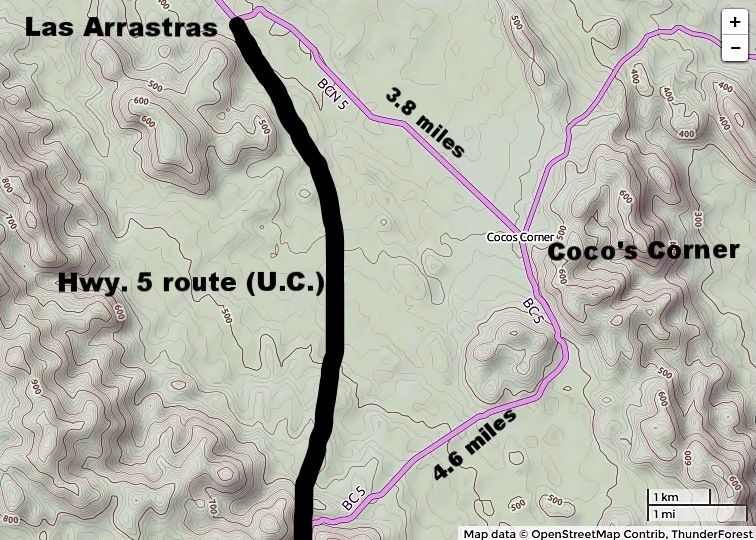
Paul, are you talking about some other dashed line? The new highway most certainly does bypass Coco's as I have shown... It continues straight south
at Las Arrastras to the canyon area. The old road (the current road) curves east at Las Arrastras then bends southward to Coco's Corner and soon after
turns west to the canyon area where it rejoins the new highway route.
Here's an earlier depiction I did once we saw the direction (and dust) of new construction, a couple years ago:
[Edited on 2-13-2018 by David K]
|
|
|
Whale-ista
Super Nomad
Posts: 2009
Registered: 2-18-2013
Location: San Diego
Member Is Offline
Mood: Sunny with chance of whales
|
|
Thanks for these updates. I'm considering this option, and would be curious to hear from those who have driven south from San Diego:
Is the time saved to avoid the coastal towns/cities on Hwy 1 worth the eastern drive to Hwy 5, starting from San Diego?
And would those who have done the drive recommend driving east on US Hwy 8, then cross south thru Mexicali?
Or is it faster/simpler to cross SB at Tecate, then head east and down La Rumorosa to avoid Mexicali crossing?
Finally: Is the mileage about the same once you connect with Hwy 1 @Laguna Chapala (need to plan for gas)?
Thanks for your recommendations!
\"Probably the airplanes will bring week-enders from Los Angeles before long, and the beautiful poor bedraggled old town will bloom with a
Floridian ugliness.\" (John Steinbeck, 1940, discussing the future of La Paz, BCS, Mexico)
|
|
|
David K
Honored Nomad
Posts: 64480
Registered: 8-30-2002
Location: San Diego County
Member Is Offline
Mood: Have Baja Fever
|
|
I am in San Marcos, so north county SD... I far prefer going I-8 to El Centro then south through Mexicali (this a bit faster than 98 directly to
Calexico from Ocotillo). It is a pretty straight run through Mexicali and well signed for San Felipe.
Tecate to south Mexicali is the next option... it is just longer and you have tolls to pay plus some city traffic in Tecate. The grade down is also
much twistier and slower than I-8 down.
I feel you save at least 2 hours in over-all driving to Baja Sur from San Diego just from avoiding the Ensenada cross-city nightmare and all the farm
town traffic Camalu to San Quintin South... the twisty road south of El Rosario (and the mountains around Santo Tomas). I do miss not going through El
Rosario however.
If I can, I will try and give you the documentation between the two routes... but last time I saw Google Maps plan a route, it picked the Mexicali/San
Felipe run over the Ensenada/San Quintin run if going to Laguna Chapala or beyond.
[Edited on 2-13-2018 by David K]
|
|
|
mtgoat666
Select Nomad
Posts: 17298
Registered: 9-16-2006
Location: San Diego
Member Is Offline
Mood: Hot n spicy
|
|
| Quote: Originally posted by Whale-ista | Thanks for these updates. I'm considering this option, and would be curious to hear from those who have driven south from San Diego:
Is the time saved to avoid the coastal towns/cities on Hwy 1 worth the eastern drive to Hwy 5, starting from San Diego?
And would those who have done the drive recommend driving east on US Hwy 8, then cross south thru Mexicali?
Or is it faster/simpler to cross SB at Tecate, then head east and down La Rumorosa to avoid Mexicali crossing?
Finally: Is the mileage about the same once you connect with Hwy 1 @Laguna Chapala (need to plan for gas)?
Thanks for your recommendations! |
from san diego, i think 5 is longer mileage but saves a few minutes over 1. but 1 has ensenada and catavina and pretty mountains, and 5 is a bit ugly
and often a bit too hot.
i do like the lighter traffic/wider lanes of 5.
I8 to mexicali is fastest way to 5.
i sometimes drive south on 1, and north on 5.
Woke!
“...ask not what your country can do for you – ask what you can do for your country.” “My fellow citizens of the world: ask not what America
will do for you, but what together we can do for the freedom of man.”
Prefered gender pronoun: the royal we
|
|
|
basautter
Senior Nomad
Posts: 862
Registered: 7-1-2013
Member Is Offline
|
|
Great info, will be passing through in April. 
|
|
|
| Pages:
1
2
3 |


