| Pages:
1
2
3 |
kbrauner
Newbie
Posts: 12
Registered: 3-5-2013
Member Is Offline
|
|
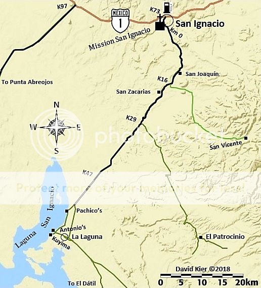
San Juanico / Scorpion Bay north to Laguna San Ignacio
Does anyone have semi-current information on either or both of the two roads from San Juanico / Scorpion Bay north to Laguna San Ignacio? I'm
interested in both the high road and the low road (through El Dátil).
|
|
|
David K
Honored Nomad

Posts: 64480
Registered: 8-30-2002
Location: San Diego County
Member Is Offline
Mood: Have Baja Fever
|
|
Please see my trip reports for 2017. I traveled over 11,000 miles in Baja and posted the details, maps, mileages in the Nomad Baja Trip Reports forum.
San Ignacio south was Trip #6, last August. It was easy, I drove the Salina route via El Datil.
|
|
|
David K
Honored Nomad
Posts: 64480
Registered: 8-30-2002
Location: San Diego County
Member Is Offline
Mood: Have Baja Fever
|
|
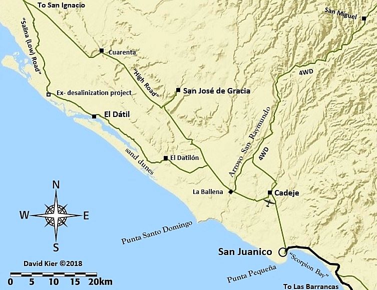
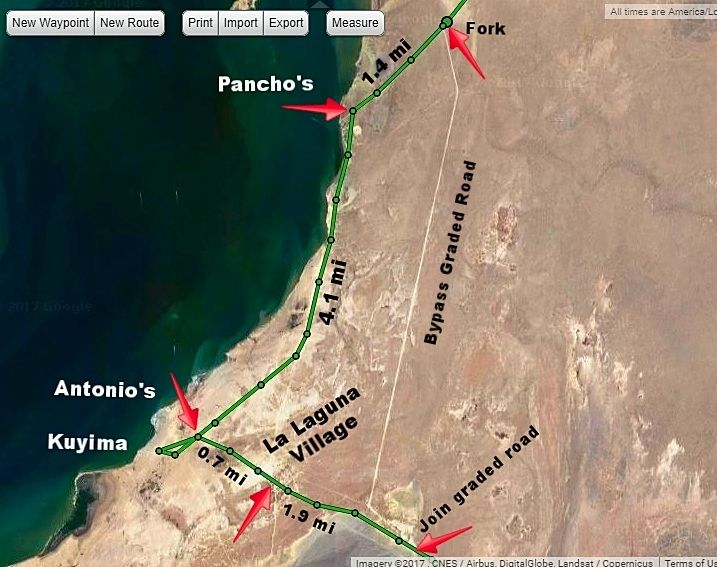
Here's my GPS track with mileages from San Juanico to El Datil:
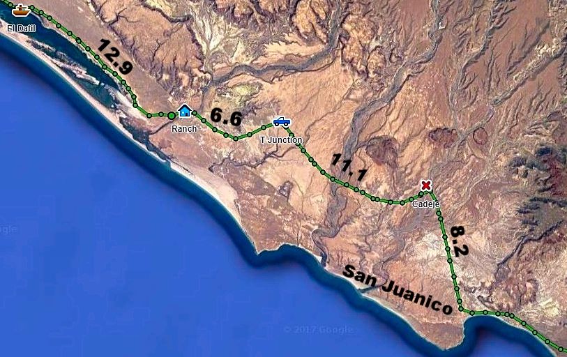
El Datil north to the junction with the high road:
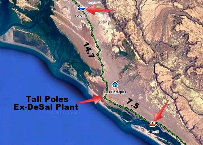
At Laguna San Ignacio:
----------------------------------------------------------------------------------------------------------------
|
|
|
TMW
Select Nomad
Posts: 10659
Registered: 9-1-2003
Location: Bakersfield, CA
Member Is Offline
|
|
The high road north of El Cuarenta has been damaged by rain from a couple of years ago. I have not heard of anyone getting thru in the last year or
two. Martin at the ranch told us to take the cut across rd to Los Batequis shown in Davids picture above. If anyone has been on it recently it would
have been Nomad Desertbull and bikers probably.
|
|
|
Desertbull
Senior Nomad
Posts: 558
Registered: 8-27-2003
Member Is Offline
|
|
The high road is passable, but slow going. Something like 50+ washouts which force you to go around, into, over, through, each of them one way or
another...from San Jose de Gracia the road is good as traffic to and from SJG is daily ... ... as listed on DK's map its named the High Road...the
other trail listed is called "The Salt Flats" and DK is missing a road which we call the "Sand Highway" and splits them in half ... many think the
Sand Highway is really a good road until we take them on the Salt Flats and run 60 mph all the way ... smoother then Mex Why 1 in Catavina.  Enjoy and get out and explore. Stop in San Juanico for a cold beer! Sit on the
beach and slow down. Life is good! Enjoy and get out and explore. Stop in San Juanico for a cold beer! Sit on the
beach and slow down. Life is good!
DREAM IT! PLAN IT! LIVE IT!
|
|
|
David K
Honored Nomad
Posts: 64480
Registered: 8-30-2002
Location: San Diego County
Member Is Offline
Mood: Have Baja Fever
|
|
Thanks Tim.
About where does this "Sand Highway" join in (on the north and south ends)? It is not shown, as I did not see or hear of it before my trip last
August, I was going by TW's notes before I let... not that I had the time to loop back over any more road that trip.
|
|
|
TMW
Select Nomad
Posts: 10659
Registered: 9-1-2003
Location: Bakersfield, CA
Member Is Offline
|
|
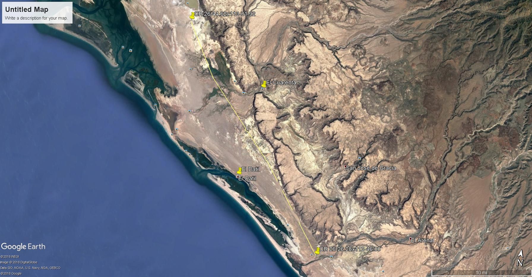
I traced a road between 26-44.62x113-01.92 on the north end. It's a split off the main road south of the split to El Datil. This center road rejoins
the main road from El Datil at 26-26.28x112-46.00. It appears to be a pretty straight road but I lost it in two sections in the bottom half. Google
Earth was dated Jan 2015.
Maybe this is the road Desertbull was talking about.
|
|
|
Tomas Tierra
Super Nomad
Posts: 1281
Registered: 3-23-2005
Location: oxnard, ca
Member Is Offline
Mood: Tengo Flojera
|
|
That middle road is woopty doo city. Prolly fun on a bike but no bueno in a truck, a real camper scrambler. However it ican be the only option
during/after rain. Better then when the sand is hard
I “heard” recently that the upper road is what “everybody” is using right now. Reputable source SJ local one month ago. FWIW
TT
|
|
|
Eatmorefish
Newbie
Posts: 2
Registered: 3-6-2018
Member Is Offline
|
|
Desertbull, when you say the road is good and traffic is daily to and from SJG, is that from the north or south? Also, what's your opinion on making
the trip, via the salt flats, w two wheel drive? A member of our small group has a vanagon. Thanks in advance.
|
|
|
David K
Honored Nomad
Posts: 64480
Registered: 8-30-2002
Location: San Diego County
Member Is Offline
Mood: Have Baja Fever
|
|
fwiw, since I used the salt flat road, let me advise to keep to the inland edge route (rather than the shorter, cross flats route). Perhaps not do
that way during full or new moon phases (for the tides) or after rain. The north end, near the fork with the high road was pretty rough washboard.
|
|
|
Desertbull
Senior Nomad
Posts: 558
Registered: 8-27-2003
Member Is Offline
|
|
if you have multiple vehicles and one is 4WD to give the other ones a short tow if they are stuck in the sand then yes, Vanagon good to go but only on
the low route .. the Vanagon will not make it thru the middle route aka Sand Highway .... like DK says if the full moon and tide flood the low route
might be tough on a Vanagon ... the locals do it daily but they have knowledge of ALL the routes ... even the low tidal route has 20 different
variations of connecting trails ... and the locals know them all.
Quote: Originally posted by Eatmorefish  | | Desertbull, when you say the road is good and traffic is daily to and from SJG, is that from the north or south? Also, what's your opinion on making
the trip, via the salt flats, w two wheel drive? A member of our small group has a vanagon. Thanks in advance. |
DREAM IT! PLAN IT! LIVE IT!
|
|
|
TheEL
Newbie
Posts: 9
Registered: 7-18-2017
Member Is Offline
|
|
Ive heard that the north high road is great right now. Only a few spots of moondust. I think I'm gonna go for it this week unless someone has some
newer info?
Last time I took the "sand highway." It was fine for me in an AWD van. Helped a guy get unstuck in his 2wd toyota sequoia. When we linked up with the
last of the salt flats it was smooth sailing until the very last one where we chose poorly and didn't go all the way to the side of the flat. I made
it through but my friend got high centered in his subaru outback. Digging him out was fun. yea... fun.
|
|
|
David K
Honored Nomad
Posts: 64480
Registered: 8-30-2002
Location: San Diego County
Member Is Offline
Mood: Have Baja Fever
|
|
| Quote: Originally posted by TheEL | Ive heard that the north high road is great right now. Only a few spots of moondust. I think I'm gonna go for it this week unless someone has some
newer info?
Last time I took the "sand highway." It was fine for me in an AWD van. Helped a guy get unstuck in his 2wd toyota sequoia. When we linked up with the
last of the salt flats it was smooth sailing until the very last one where we chose poorly and didn't go all the way to the side of the flat. I made
it through but my friend got high centered in his subaru outback. Digging him out was fun. yea... fun. |
It has been many months since the previous post to yours. Desert Bull has said recently the high road is now the preferred route as road graders had
made it very fast. When I went through the area 12 months ago, the high road had many reported washouts from floods and the Salina (low) road was
preferred. If one stays to the inland edge tracks and doesn't short-cut across on the straight tracks, you will miss mud holes. Your choice... the low
road is only a couple of miles longer than the high road... but best done in an SUV or truck, imo.
|
|
|
CarneAsada
Newbie
Posts: 3
Registered: 7-28-2019
Member Is Offline
|
|
High tides and the low road
I'm headed down to San Juanico for the first week in August. It looks like the tides are going to pretty high that week (6-7 foot high tides). Do
these kind of tides make the low road impassable?
|
|
|
David K
Honored Nomad
Posts: 64480
Registered: 8-30-2002
Location: San Diego County
Member Is Offline
Mood: Have Baja Fever
|
|
| Quote: Originally posted by CarneAsada | | I'm headed down to San Juanico for the first week in August. It looks like the tides are going to pretty high that week (6-7 foot high tides). Do
these kind of tides make the low road impassable? |
That is why there is a high road. It was re-graded after my trip 2 years ago when the low road was the only choice for most.
|
|
|
Mulege Canuck
Nomad
Posts: 386
Registered: 11-27-2016
Member Is Offline
|
|
Anyone done the north low road on the tidal flats to San Juanico lately?
|
|
|
AKgringo
Elite Nomad
Posts: 5809
Registered: 9-20-2014
Location: Anchorage, AK (no mas!)
Member Is Offline
Mood: Retireded
|
|
How soon are you planning to drive the flats? The reason I ask, is because we are just past a few day of full moon tides, and I have seen areas
flooded here in La Paz that are usually dry in normal tide cycles.
I drove from San Ignacio to San Juanico two weeks ago, but never got near the flats. I never found a need for putting the front axle to work, and did
not find any truly hateful stretches of wash board.
If you are not living on the edge, you are taking up too much space!
"Could do better if he tried!" Report card comments from most of my grade school teachers. Sadly, still true!
|
|
|
Bajazly
Senior Nomad
Posts: 992
Registered: 6-4-2015
Location: Goodbye Cali and Hello San Felipe
Member Is Offline
Mood: More Relaxed Everyday
|
|
Week between Christmas and New Years was stellar and I don't think they have had any weather down there to make it sloppy. In fact, we were there
after the rains in December and a lot of places we went were wet but the low road was fine.
Believing is religion - Knowing is science
Harald Pietschmann
"Get off the beaten path and memories, friends and new techniques are developed"
Bajazly, August 2019
|
|
|
Mulege Canuck
Nomad
Posts: 386
Registered: 11-27-2016
Member Is Offline
|
|
I am planning on heading that way on Feb 20 th. Tides will be lower then. I drove that route last year on the flats and it was an easy drive with
our camper.
Thanks for the information boys.
|
|
|
Mulege Canuck
Nomad
Posts: 386
Registered: 11-27-2016
Member Is Offline
|
|
Just got back from San Juanico to San Ignacio on the tidal low road.
The gravel road from San Juanico to the El Datil turnoff was washboard with a few rough sections they have not repaired yet. No big deal for a Taco
but was slow going with a F350 and camper.
Once on the salt flats the road was good but they have had some big tides there so make sure not to take any “Mexican shortcuts “ across the
flats. Stay close to the vegetation and all will be good. Met a guy in San Ignacio who got stuck pretty bad on the flats. Maybe he cheated a little
and got P-nched.
We stayed on the point past Camp El Delgadito. Not great spot for fishing but it is beautiful spot for kayaking at high tide with lots of bird life.

[Edited on 2-20-2020 by Mulege Canuck]
[Edited on 2-20-2020 by Mulege Canuck]
|
|
|
| Pages:
1
2
3 |


