BajaNomad
Not logged in [Login - Register]

Go To Bottom
Printable Version  
 Pages:  1    3
Author: Subject: 1971 AAA Baja Map (July 1971) for historical interest
David K
Honored Nomad
*********


Avatar


Posts: 64476
Registered: 8-30-2002
Location: San Diego County
Member Is Offline

Mood: Have Baja Fever

[*] posted on 2-8-2018 at 04:21 PM
1971 AAA Baja Map (July 1971) for historical interest


Before 1975 and sometime after the late 1960s, the AAA map (actually was the Auto Club of Southern California) had a large scale map of northern Baja and the smaller scale of the rest of Baja on the other side. That smaller scale was the same style map they had for all of Baja in the early 1960s and before.

I have 9 scans of this 1971 map provided by TW (TMW on Nomad).


The new (then) highway is not accurate south of Santiago nor was there a paved 6 mile road to Agua Caliente... just a couple quick observations.

If I missed an area you want to see or if you want me to zoom in on any area to see better... just ask!

I will scan the Sept. 1973 edition of the Baja map next...


"So Much Baja, So Little Time..."

See the NEW www.VivaBaja.com for maps, travel articles, links, trip photos, and more!
Baja Missions and History On Facebook: https://www.facebook.com/groups/bajamissions/
Camping, off-roading, Viva Baja discussion: https://www.facebook.com/groups/vivabaja


View user's profile Visit user's homepage
Mateo-Feo
Nomad
**


Posts: 101
Registered: 8-1-2012
Location: San diego
Member Is Offline

Mood: MuchoTakeitEasy

[*] posted on 2-9-2018 at 10:14 PM


Wow this is cool
View user's profile
Barry A.
Select Nomad
*******


Posts: 10007
Registered: 11-30-2003
Location: Redding, Northern CA
Member Is Offline

Mood: optimistic

[*] posted on 2-21-2018 at 01:08 PM


Quote: Originally posted by David K  
Quote: Originally posted by Mateo-Feo  
Wow this is cool


I think so, too! Like looking back in time.
Soon, I will put up the 1973 map that TW sent me. The Olympics have been distracting me! The '73 map shows the proposed or under construction route of the new highway.

Does anyone have the 1972 AAA Baja map?


(This new format has me totally confused. See another post below)

[Edited on 2-21-2018 by Barry A.]

[Edited on 2-21-2018 by Barry A.]
View user's profile
Hook
Elite Nomad
******


Posts: 9006
Registered: 3-13-2004
Location: Sonora
Member Is Offline

Mood: Inquisitive

[*] posted on 2-21-2018 at 01:17 PM


I never was on any of the unpaved sections of the transpeninsular hwy (though I was going down to Ensenada from '69 on), but I did drive the
hwy between Ensenada and San Felipe in '73, before it was completely paved. Seemed like it was only the section across Laguna Diablo that was still dirt.

My gal and I had lunch at Arnold's Cafe and drove all the way back to Ensenada in the same day!! We were blown away at the temp change (especially the water) between Ensenada and San Felipe.
View user's profile
Barry A.
Select Nomad
*******


Posts: 10007
Registered: 11-30-2003
Location: Redding, Northern CA
Member Is Offline

Mood: optimistic

[*] posted on 2-21-2018 at 01:21 PM


David----I have 3 Auto Club Baja maps that are so old I can't find any publishing date on them.

Also a 1963 "Kym's Guide" map of Baja.

Also a AAA map of Baja dated 1973, but it has a big trip tp Cabo plotted on it with red and black ink.

These are all my Aunt Becky McSheehy's Baja maps from way back when in the '40's, 50's, 60's and newer.

Also, AAA "Baja Log" books from 1959, 1963, l975, l979 and 1984, and beyond.

If interested send me an e-mail.

Barry
View user's profile
David K
Honored Nomad
*********


Avatar


Posts: 64476
Registered: 8-30-2002
Location: San Diego County
Member Is Offline

Mood: Have Baja Fever

[*] posted on 2-21-2018 at 03:46 PM


Quote: Originally posted by Hook  
I never was on any of the unpaved sections of the transpeninsular hwy (though I was going down to Ensenada from '69 on), but I did drive the
hwy between Ensenada and San Felipe in '73, before it was completely paved. Seemed like it was only the section across Laguna Diablo that was still dirt.

My gal and I had lunch at Arnold's Cafe and drove all the way back to Ensenada in the same day!! We were blown away at the temp change (especially the water) between Ensenada and San Felipe.


Indeed! Night and day difference.
The pavement out of Ensenada in November of 1973 ended just a few miles east of Ojos Negros. We camped there to watch the Baja 1000. In my Super 8 movie you can see the highway under construction as the racers were on the parallel dirt road. It wasn't until late 1977 or '78 did they reach Hwy. 5. It was first BC #16 before the Feds took over and gave it the same name as the Tecate to Ensenada highway, Mexico #3.


"So Much Baja, So Little Time..."

See the NEW www.VivaBaja.com for maps, travel articles, links, trip photos, and more!
Baja Missions and History On Facebook: https://www.facebook.com/groups/bajamissions/
Camping, off-roading, Viva Baja discussion: https://www.facebook.com/groups/vivabaja


View user's profile Visit user's homepage
sundance007
Newbie


Posts: 2
Registered: 2-22-2018
Member Is Offline


[*] posted on 2-22-2018 at 01:50 PM


Wow that is amazing. I would love to do the Baja 1000 someday. A bucketlist item.
View user's profile
David K
Honored Nomad
*********


Avatar


Posts: 64476
Registered: 8-30-2002
Location: San Diego County
Member Is Offline

Mood: Have Baja Fever

[*] posted on 2-22-2018 at 03:18 PM


Quote: Originally posted by sundance007  
Wow that is amazing. I would love to do the Baja 1000 someday. A bucketlist item.

Just get involved in someway. That Super 8 movie I filmed at 16. I began going to see the races many times after. In 1978 I was asked if I would hold a fire extinguisher at a pit during the Baja 500 and pretty soon I was a pit captain at various races. In 1979, I was invited to co-drive in the first Baja 1000 that Score ran to La Paz. Just be where you want to be in life, and it can happen!


"So Much Baja, So Little Time..."

See the NEW www.VivaBaja.com for maps, travel articles, links, trip photos, and more!
Baja Missions and History On Facebook: https://www.facebook.com/groups/bajamissions/
Camping, off-roading, Viva Baja discussion: https://www.facebook.com/groups/vivabaja


View user's profile Visit user's homepage
Cliffy
Senior Nomad
***


Posts: 983
Registered: 12-19-2013
Member Is Offline


[*] posted on 2-22-2018 at 05:09 PM


HEHE I still have my AAA map from the 70s buried somewhere.
It looks to like the racers were just coasting through the area slowly :-)


You chose your position in life today by what YOU did yesterday
View user's profile
BajaBlanca
Select Nomad
*******


Posts: 13165
Registered: 10-28-2008
Location: La Bocana, BCS
Member Is Offline


[*] posted on 2-22-2018 at 08:25 PM


La Bocana isn't even on that map! Holy smokes.

Very cool to look at older maps...thanks for sharing.


Come visit La Bocana


https://sites.google.com/view/bajabocanahotel/home

And always remember, life is not measured by the number of breaths we take, but by those moments that take our breath away.
View user's profile Visit user's homepage
AlanDavid90
Junior Nomad
*


Posts: 27
Registered: 11-12-2017
Member Is Offline


[*] posted on 5-23-2018 at 10:47 PM


Stunning Map of Baja in 1971
View user's profile
PaulW
Ultra Nomad
*****


Posts: 3004
Registered: 5-21-2013
Member Is Offline


[*] posted on 5-25-2018 at 06:57 AM


South of San Felipe there are two roads. The old Puerticitos road (OPR) and the current road closer to the Sea. What was the time period when the transition from OPR to the present road path?
Any old maps showing both?
A friend and resident for 40 years remembers driving south using OPR. I wonder if his memory is good?
View user's profile
David K
Honored Nomad
*********


Avatar


Posts: 64476
Registered: 8-30-2002
Location: San Diego County
Member Is Offline

Mood: Have Baja Fever

[*] posted on 5-25-2018 at 08:40 AM


Quote: Originally posted by PaulW  
South of San Felipe there are two roads. The old Puerticitos road (OPR) and the current road closer to the Sea. What was the time period when the transition from OPR to the present road path?
Any old maps showing both?
A friend and resident for 40 years remembers driving south using OPR. I wonder if his memory is good?


The new graded roadbed (future paved road) south from Punta Estrella was built in 1982 and could be driven just a ways beyond La Roca, about to La Perlita/ Agua Azul de Acapulco and bulldozer clearing was progressing south.

Paving came several years later, around 1990... and was so thin that by 1999 it was well deteriorated.

My map in 1980, before the new road:


Here is my 1982 map showing both:
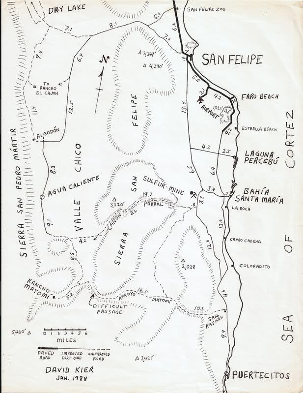


Jan. 1988:


Pavement progressed from the Hotel Fiesta to just beyond Punta Estrella (about where the Valle de los Gigantes is now)

----------------------------------------------------------------------------------------------------
AAA Before and after:

1978:


1987:


(my notes on the progress south of Puertecitos on the new graded road)

1989:


(The incorrectly showed paving to Percebu)

1990:


(They corrected the mistake from 1989 map paving to Percebu)

1996:


(Pavement reached Puertecitos)

2000:


(Pavement already vanishing near Puertecitos)

2001:


(More pavement gone)

2003:


2004:


2007:


(Road repaved to Puertecitos)


[Edited on 5-25-2018 by David K]


"So Much Baja, So Little Time..."

See the NEW www.VivaBaja.com for maps, travel articles, links, trip photos, and more!
Baja Missions and History On Facebook: https://www.facebook.com/groups/bajamissions/
Camping, off-roading, Viva Baja discussion: https://www.facebook.com/groups/vivabaja


View user's profile Visit user's homepage
TMW
Select Nomad
*******


Posts: 10659
Registered: 9-1-2003
Location: Bakersfield, CA
Member Is Offline


[*] posted on 5-25-2018 at 11:19 AM


The pavement to Puertecitos was completed in 1988. We ran the 1987 Baja 1000 which came out of Matomi wash onto the graded road. We ran the 1988 Baja 1000, same course, and when it came out of Matomi wash it was on new pavement. What a difference a year made but it was not to last since the pavement was so thin potholes soon developed.
View user's profile
basautter
Senior Nomad
***


Posts: 862
Registered: 7-1-2013
Member Is Offline


[*] posted on 5-25-2018 at 12:36 PM


Very cool! Thanks for sharing :light:
View user's profile
David K
Honored Nomad
*********


Avatar


Posts: 64476
Registered: 8-30-2002
Location: San Diego County
Member Is Offline

Mood: Have Baja Fever

[*] posted on 5-25-2018 at 03:24 PM


Quote: Originally posted by TMW  
The pavement to Puertecitos was completed in 1988. We ran the 1987 Baja 1000 which came out of Matomi wash onto the graded road. We ran the 1988 Baja 1000, same course, and when it came out of Matomi wash it was on new pavement. What a difference a year made but it was not to last since the pavement was so thin potholes soon developed.


It must have been really thin, indeed... because in January of 1988 it was dirt just past Punta Estrella, 40 miles from Puertecitos.

As I recall, the (lazy) government person who issued the check to the paving contractor simply flew over it to see if it was done and never took any core samples to see if the correct amount of asphalt was used. He obviously also didn't see how the road vados were not regraded for pavement speed (Oh Sh!@ Dips)! I heard that contractor was jailed. Not sure what happened to the lazy government person??


"So Much Baja, So Little Time..."

See the NEW www.VivaBaja.com for maps, travel articles, links, trip photos, and more!
Baja Missions and History On Facebook: https://www.facebook.com/groups/bajamissions/
Camping, off-roading, Viva Baja discussion: https://www.facebook.com/groups/vivabaja


View user's profile Visit user's homepage
TMW
Select Nomad
*******


Posts: 10659
Registered: 9-1-2003
Location: Bakersfield, CA
Member Is Offline


[*] posted on 5-25-2018 at 07:52 PM


There were places where the potholes were that the asphalt looked to be only 1/4 inch thick.
View user's profile
PaulW
Ultra Nomad
*****


Posts: 3004
Registered: 5-21-2013
Member Is Offline


[*] posted on 5-25-2018 at 09:50 PM


David all the maps on this thread have disappeared?
View user's profile
BajaBill74
Nomad
**


Posts: 253
Registered: 1-27-2014
Member Is Offline

Mood: Beyond Extatic!

[*] posted on 5-26-2018 at 08:18 AM


David, I find them "disappeared" too.


What I'm doing at work is so secret, even I don't know what I'm doing!

One should believe in God, because even Google doesn't know everything.
View user's profile Visit user's homepage
AKgringo
Elite Nomad
******


Posts: 5805
Registered: 9-20-2014
Location: Anchorage, AK (no mas!)
Member Is Offline

Mood: Retireded

[*] posted on 5-26-2018 at 08:49 AM


David, I can see the maps on this thread right now, but I just tried to view your trip report #2, and none of the photos come up for me!


If you are not living on the edge, you are taking up too much space!

"Could do better if he tried!" Report card comments from most of my grade school teachers. Sadly, still true!
View user's profile
 Pages:  1    3

  Go To Top


All Content Copyright 1997- Q87 International; All Rights Reserved.
Powered by XMB; XMB Forum Software © 2001-2014 The XMB Group


"If it were lush and rich, one could understand the pull, but it is fierce and hostile and sullen. The stone mountains pile up to the sky and there is little fresh water. But we know we must go back if we live, and we don't know why." - Steinbeck, Log from the Sea of Cortez


"People don't care how much you know, until they know how much you care." - Theodore Roosevelt


"You can easily judge the character of others by how they treat those who they think can do nothing for them or to them." - Malcolm Forbes


"Let others lead small lives, but not you. Let others argue over small things, but not you. Let others cry over small hurts, but not you. Let others leave their future in someone else's hands, but not you." - Jim Rohn


"The best way to get the right answer on the internet is not to ask a question; it's to post the wrong answer." - Cunningham's Law


Thank you to Baja Bound Mexico Insurance Services for your long-term support of the BajaNomad.com Forums site.


Emergency Baja Contacts Include:

Desert Hawks; El Rosario-based ambulance transport; Emergency #: (616) 103-0262