| Pages:
1
2
3 |
PaulW
Ultra Nomad

Posts: 3005
Registered: 5-21-2013
Member Is Offline
|
|
Images are coming and going. When I try to reply with my discussion of a single map - nothing when I preview.
Restart
Now no maps show up. Looks like a site problem???
|
|
|
PaulW
Ultra Nomad
Posts: 3005
Registered: 5-21-2013
Member Is Offline
|
|
Anyway without an image I have questions for David
* I really like your maps. How did you do your map making with all the mileage detail? Pretty accurate I might add.
* Regarding your '82? map that shows the detail of the Matomi area. I have had conversations with two old timers that said OPR entered Matomi from the
north then went east to where hwy 5 is now then continued south. Then later this route was discontinued to become what you show in the '82 map for
hwy 5. My question is there any thing older that can verify that route or is just fictional?
|
|
|
SFandH
Elite Nomad
Posts: 6925
Registered: 8-5-2011
Member Is Offline
|
|
The server the images are on isn't responding, at least right now.
http://s213.photobucket.com
100% packet loss on a ping.
|
|
|
AKgringo
Elite Nomad
Posts: 5807
Registered: 9-20-2014
Location: Anchorage, AK (no mas!)
Member Is Offline
Mood: Retireded
|
|
The issue seems to have been resolved. I just tried the Trip report #2 thread again, and all the photos are there!
If you are not living on the edge, you are taking up too much space!
"Could do better if he tried!" Report card comments from most of my grade school teachers. Sadly, still true!
|
|
|
David K
Honored Nomad
Posts: 64479
Registered: 8-30-2002
Location: San Diego County
Member Is Offline
Mood: Have Baja Fever
|
|
Quote: Originally posted by PaulW  | Anyway without an image I have questions for David
* I really like your maps. How did you do your map making with all the mileage detail? Pretty accurate I might add.
* Regarding your '82? map that shows the detail of the Matomi area. I have had conversations with two old timers that said OPR entered Matomi from the
north then went east to where hwy 5 is now then continued south. Then later this route was discontinued to become what you show in the '82 map for
hwy 5. My question is there any thing older that can verify that route or is just fictional? |
Hi Paul, I am away for the weekend but may get some info to you. Not sure what OPR is, but I can tell you I first visited Matomí in 1978, in from the
north and out to Puertecitos road in the arroyo. That was also the first year Score used Matomí for the 1000. It was difficult in the narrows but I
still got my Subaru through. I have been back many times and it was easy in 2001 to 2006 as sand covered the boulders. Last year was the first time I
couldn't pass through the narrows.
Edit: I have guessed OPR is Old Puertecitos Road. To answer you, it and the paved road are in the same location where it crossed Matomí. You can see
the old maps from Gulick to the AAA maps to see. The terrain allows not much other option unless you move closer to the sea.
As for my hand drawn maps, well that is my passion... Baja maps and the area south of San Felipe is where I have spent most of my Baja life at. I
drove the roads and recorded the mileage. I also drove the coast and recorded mileages and took sightings from various points to improve the accuracy.
I was 25 in 1982 and began drawing maps of the area when I was 10, in 1967. I have posted them here on Nomad, too.
[Edited on 5-26-2018 by David K]
|
|
|
BajaBill74
Nomad
Posts: 253
Registered: 1-27-2014
Member Is Offline
Mood: Beyond Extatic!
|
|
David, the pictures are 'disappearing" and "un-disappearing" when ever they feel like it. There must be an unknown reason for it.
What I'm doing at work is so secret, even I don't know what I'm doing!
One should believe in God, because even Google doesn't know everything.
|
|
|
David K
Honored Nomad
Posts: 64479
Registered: 8-30-2002
Location: San Diego County
Member Is Offline
Mood: Have Baja Fever
|
|
Paul, another proof that OPR and Hwy. 5 are in the same location across the Matomí arroyo valley is in Gulick & Gerhard's 1962 Lower California
Guidebook that describes Arroyo Matomí and the deep well just west of the road. That well is still just west of the highway. A ranch called San
Rafael was there since the 1970s. Today it is called El Pozo, at km. 60.5.
[Edited on 5-26-2018 by David K]
|
|
|
PaulW
Ultra Nomad
Posts: 3005
Registered: 5-21-2013
Member Is Offline
|
|
| Quote: Originally posted by David K | Paul, another proof that OPR and Hwy. 5 are in the same location across the Matomí arroyo valley is in Gulick & Gerhard's 1962 Lower California
Guidebook that describes Arroyo Matomí and the deep well just west of the road. That well is still just west of the highway. A ranch called San
Rafael was there since the 1970s. Today it is called El Pozo, at km. 60.5.
[Edited on 5-26-2018 by David K] |
========= ===
Thanks for the confirmation
I am now subscribed to this thread and will respond.
|
|
|
PaulW
Ultra Nomad
Posts: 3005
Registered: 5-21-2013
Member Is Offline
|
|
No question the any version of the road south passed next to the well at San Rafael just like Hwy 5 does now.
(Currently OPR hts Hwy 5 at ~Km51)
However, OPR going south passes Agua de Chale then there is a road going SW which goes around the hills to the west and enters Matomi about a mile or
2 west of San Rafael. These two old timers told me that that go around the hills road to the west was the first road south. I seriously doubt them
because Gulick implies the road was along the coast.
Gulick goes back to 1956. So -- can you find anything older?
|
|
|
David K
Honored Nomad
Posts: 64479
Registered: 8-30-2002
Location: San Diego County
Member Is Offline
Mood: Have Baja Fever
|
|
I may need to reread your post, but OPR was 4.8 miles west of Agua de Chale, it ran through the sulfur mine.
South of the sulfur mine, an old road went west over the Llanos de San Fermin to Arroyo Matomí and followed it back to OPR by that well.
This road has been used by Score many times, including last month.
It appears on many maps since Gulick included it, but never mentioned it in the guidebook.
I did see the unpublished first Gulick map of San Felipe south and indeed, before there was a direct to Puertecitos road, that Llanos de San Fermin
road was all he showed south of the sulfur mine.
|
|
|
PaulW
Ultra Nomad
Posts: 3005
Registered: 5-21-2013
Member Is Offline
|
|
Gulick has always shown the yellow road. Was the yellow road ever used before the coast road?

|
|
|
David K
Honored Nomad
Posts: 64479
Registered: 8-30-2002
Location: San Diego County
Member Is Offline
Mood: Have Baja Fever
|
|
Yes Paul, as I said in the last reply...
"I did see the unpublished first Gulick map of San Felipe south and indeed, before there was a direct to Puertecitos road, that Llanos de San Fermin
road was all he showed south of the sulfur mine."
The 1956 map in the guidebook shows the road south of San Felipe going to the sulfur mine then turning east to end at Agua de Chale. There was no map
showing the coast between San Felipe and Gonzaga Bay in the '56 book.
The 1958 map (an added map for San Felipe to Gonzaga) shows the Llanos de San Fermin road as well as the road going direct to Puertecitos (OPR) from
the sulfur mine. The guide mentioned that the camp at Puertecitos was established in 1957. Gulick's photos there in 1956 show nothing and in 1959 show
the first buildings where the cantina is.
|
|
|
TacoFeliz
Nomad
Posts: 265
Registered: 7-22-2005
Location: Here
Member Is Offline
Mood: Exploratory
|
|
Hi David -
I was surprised to see a road west from Mexico 1 directly to Punta Cabras on the AAA 1971 map. It still looks like it is intact today on Google Earth.
It's great to see the roads in use at that time. More to explore on future trips. Thanks for posting.
|
|
|
PaulW
Ultra Nomad
Posts: 3005
Registered: 5-21-2013
Member Is Offline
|
|
How about old maps that show driving paths in the San Felipe arroyos?
Azufre(Parral), Huatamote/Parral, Chanate, etc
|
|
|
PaulW
Ultra Nomad
Posts: 3005
Registered: 5-21-2013
Member Is Offline
|
|
Here is another
Some interesting mapping by Tom Tom. A popup offering mobile maps for free.
https://developer.tomtom.com/maps-sdk-web-js/functional-exam...
A quick look showed Motomi and they called “Arroyo El Rosario”. Anybody ever heard of that name?
And the old Hwy 5 thru Coco’s between new 5N to New 5S is labeled “Camino a Calamajue”
|
|
|
David K
Honored Nomad
Posts: 64479
Registered: 8-30-2002
Location: San Diego County
Member Is Offline
Mood: Have Baja Fever
|
|
This is their current map, not an old map. The calling Matomi arroyo, El Rosario, is just a stupid blunder by whoever made the map for them. If you go
pretty much west from Matomi you hit Arroyo el Rosario. The just did not separate the two.
The old road via Coco's is the road to Calamajué (both the Puerto de and the Misión de). So, that is correct. Nice they have the highway route
correct so soon.
|
|
|
David K
Honored Nomad
Posts: 64479
Registered: 8-30-2002
Location: San Diego County
Member Is Offline
Mood: Have Baja Fever
|
|
| Quote: Originally posted by PaulW | How about old maps that show driving paths in the San Felipe arroyos?
Azufre(Parral), Huatamote/Parral, Chanate, etc |
I was the the first to document the Azufre/ Parral road since it was shown on the 1971 Geological map of Baja Norte and mentioned in the 1967 edition
of Camping and Climbing in Baja. I finally found the route of the long-abandoned road in 1978. Friends traveling with me in my 4WD Subaru would keep
getting out to move rocks or debris. We could find the old road by seeing parallel grass (it was raining in December) as the water would puddle in the
slightly depressed soil from old tire tracks... and the grass would grow there, showing me the way! It was a big thrill to get through to Valle Chico
and see the Sierra San Pedro Mártir! We reached the valley road, a few miles north of Matomi Canyon and drove north to San Felipe.
I was recently in the Baja 1000 ('79) and thought Sal Fish might like to have another optional race route (instead of Matomi) to loop around in. Sal
thanked me and invited me to work with SCORE on mapping. I did not follow through on his kind offer.
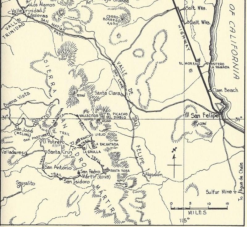
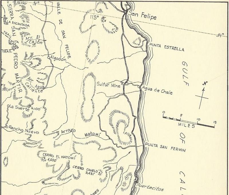
Here are some of my old maps of the roads south of San Felipe...
1980:
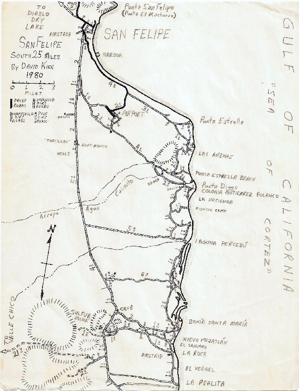
1982:
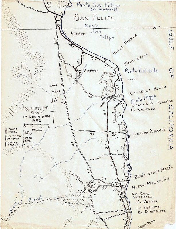
1982:
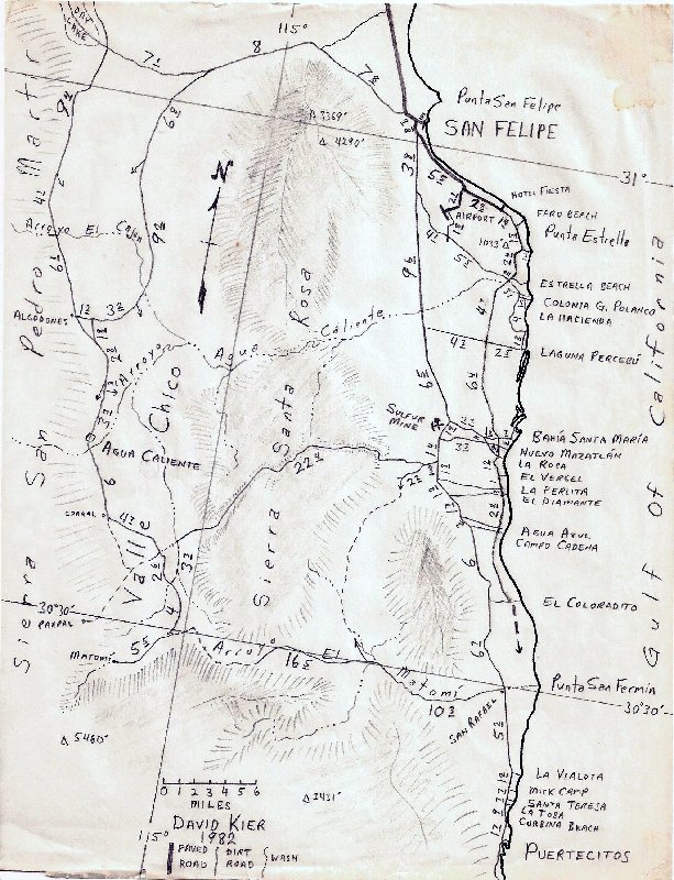
1988:
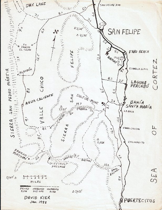
2004:

[Edited on 3-14-2020 by David K]
|
|
|
PaulW
Ultra Nomad
Posts: 3005
Registered: 5-21-2013
Member Is Offline
|
|
Now days from the south:
Matomi
Azufre leads west from the sulphur mine
Huatamote leads west from the Percebu area--(or Pancho's Place)
Chanate leads west from Punta Estrella and the airport
Amarillas leads west from the airport. (and dead ends in Hidden valley)
80 map.
Agua Caliente arroyo is probably Chanate?
The the unnamed one leading west from Percebu is probably Huatamote? Any history on that name as it ended up in the Almanac.
Agree Azufre should properly be called Parral, but the issue was to many Parral's. Therefore an new name was chosen by SCORE (Paul Fish). A naming
that Probably should not have been done IMO.
82 Agua Caliente again
Any incite how the name became Chanate? Been that way for a long time. Still not named in the Almanac
|
|
|
David K
Honored Nomad
Posts: 64479
Registered: 8-30-2002
Location: San Diego County
Member Is Offline
Mood: Have Baja Fever
|
|
I got the name Agua Caliente for that arroyo from maps available at the time... It was changed to Hauatmote on the topo maps/ Baja Almanac and later
editions of the AAA map.
See here the 1974 AAA map: Arroyo Agua Caliente:
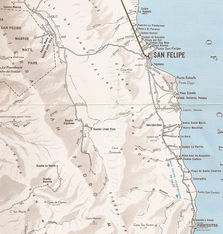
On the 1962 Gulick map, the only arroyo of the many branches that leads out to Punta Estrella is Arroyo Agua Caliente:

|
|
|
PaulW
Ultra Nomad
Posts: 3005
Registered: 5-21-2013
Member Is Offline
|
|
thanks
|
|
|
| Pages:
1
2
3 |